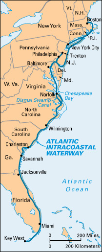
Atlantic Intracoastal Waterway is a sheltered water route used by boats along the Atlantic Coast of the United States. It consists of a series of rivers, estuaries, inland bays, sounds, and inlets, nearly all linked by canals.

United States Army engineers are continually dredging the 1,200-mile (1,930-kilometer) waterway. Its channel has a depth of 12 feet (3.7 meters) or more. Barges and small pleasure boats travel on the waterway. These vessels are exposed to the open ocean for only about 50 miles (80 kilometers) south from Boston, along the Rhode Island coast, and for a 37-mile (60-kilometer) stretch along the New Jersey coast. A canal extends from Philadelphia to Chesapeake Bay. The remainder of the waterway lies back from the shoreline, or is protected by islands and sand bars.
About 175 bridges cross the Atlantic Intracoastal Waterway. Twenty-two lighthouses help guide the vessels. Water locks lift and lower boats to different levels in the Dismal Swamp Canal in eastern Virginia and in eastern North Carolina.
A one-way voyage on the waterway takes about 10 days for small vessels. The trip presents scenery ranging from the busy shipping scenes at New York Harbor to the lonely wilderness along the Carolina coast and the colorful resorts in Florida. Many colonists in America founded settlements on streams and bays of the Atlantic seaboard. They were among the first to use the coastal and inland waterways for travel, trade, and communication along the coast.
