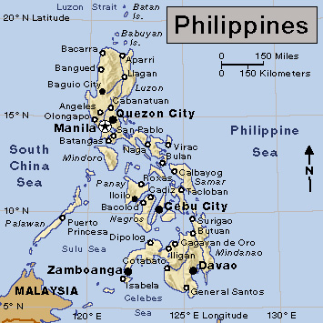
Manila (pop. 1,846,513; met. area pop. 13,484,462) is the capital of the Philippines and one of the country’s largest cities. The city is the economic, political, social, and educational center of the country. Manila also serves as the nation’s chief international port of entry for cargo and passengers. Manila is part of the National Capital Region (NCR) , one of 17 administrative regions in the Philippines. The NCR consists of the Manila metropolitan area, also known as Metro Manila.
Manila’s name combines two words of Filipino, the Philippines’ national language. May means there is, and nilad is a shrub that grew along the shores of the bay. Originally Maynilad, the name was shortened first to Maynila and later to Manila.
The city
Location.
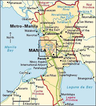
Manila lies along Manila Bay on the western shore of Luzon, the northernmost major island of the Philippines. The city occupies the low plain at the mouth of the Pasig River. The river enters the China Sea through a wide channel within Manila Bay. The river deposited silt on the plain. Much of the city stands on this bed of silt. Manila also occupies some land that has been reclaimed from the sea. The site is only a few meters above sea level. A large portion of Manila once stood on marshy ground. To the north of Manila are the cities of Caloocan and Navotas. To the northeast is Quezon City. To the east are San Juan and Mandaluyong. To the southeast are Pasay and Makati.
Manila has a humid, tropical climate. The warmest months are April and May. The coolest are January and February. The temperature varies slightly from month to month. The nights are generally mild due to the land and sea breezes. There are distinct wet and dry seasons. It is wet from May to December and dry from November to April. The wettest months are July and August. The Sierra Madre Mountains and the mountains of the Bataan Peninsula protect the city from typhoons west of Manila Bay. The sheltered harbor and the rich agricultural areas nearby make Manila an excellent port.
Description.
The American architect Daniel Burnham prepared the plan of the city in 1905 (see Burnham, Daniel Hudson). His plan called for the development of the waterfront and the creation of parks and parkways to provide recreation in every section of the city. The plan also called for the establishment of a street system that would provide direct and easy connection to every part of the city, the development of waterways for transportation, and the establishment of summer resorts.
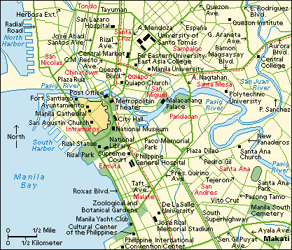
The city developed in a less orderly manner than Burnham had planned, however. The central business area grew up within the market complexes of the Quiapo and Santa Cruz districts. Most of the transport systems from the different parts of the city meet in these areas. The Pasig River divides the city into 16 administrative districts. The districts of Tondo, San Nicolas, Binondo, Santa Cruz, Quiapo, San Miguel, Santa Mesa, and Sampaloc are north of the river. Port Area, Intramuros, Ermita, Malate, Paco, Pandacan, San Andres, and Santa Ana are in the south. Each district (with the exception of Port Area) has its own commercial center, church, and schools.
North of the river, the districts of Quiapo, Santa Cruz, San Nicolas, and Binondo are the principal centers of trade and commerce. Many people live in Tondo. Tondo occupies the northern shore and is the port of entry for domestic vessels. San Miguel is the site of Malacañan Palace. The palace once served as the residence of Spanish and American governors general. It has also served as home to some Philippine presidents and remains the official residence.
Port Area occupies the southern shore of the Pasig as the river enters Manila Bay. It is the port of entry for international vessels. There are several universities in Sampaloc. They include the University of Santo Tomás, National University, the University of Manila, and the University of the East. Paco, Pandacan, and Santa Ana are middle-income residential areas. Ermita and Malate are the most expensive residential areas. They face Manila Bay. There are many hotels and embassies in this area, including the embassy of the United States.
People
Five hundred years ago, Manila was a string of villages beside Manila Bay. It eventually grew into a bustling metropolis. The city has attracted many migrants from different parts of the country who have come in search of employment, education, and trade. This caused a rapid increase in population, especially during the 1900’s.
Population.
Today, Manila has one of the world’s highest population densities (number of people per square mile). However, the distribution of inhabitants is uneven. Tondo is the most heavily populated district. Overall, the city’s population is young because of a high birth rate, large family size, and the influx of young adults seeking employment opportunities.
Manila has a varied population. The majority of the people are Filipinos, and a small percentage are Chinese. Other groups include Americans, Europeans, and people from mainland Asia.
Most of the people are Roman Catholics. Other religious groups include Protestants, Buddhists, and members of two national Christian churches, the Iglesia ni Cristo and the Aglipayans.
Archtecture and housing.
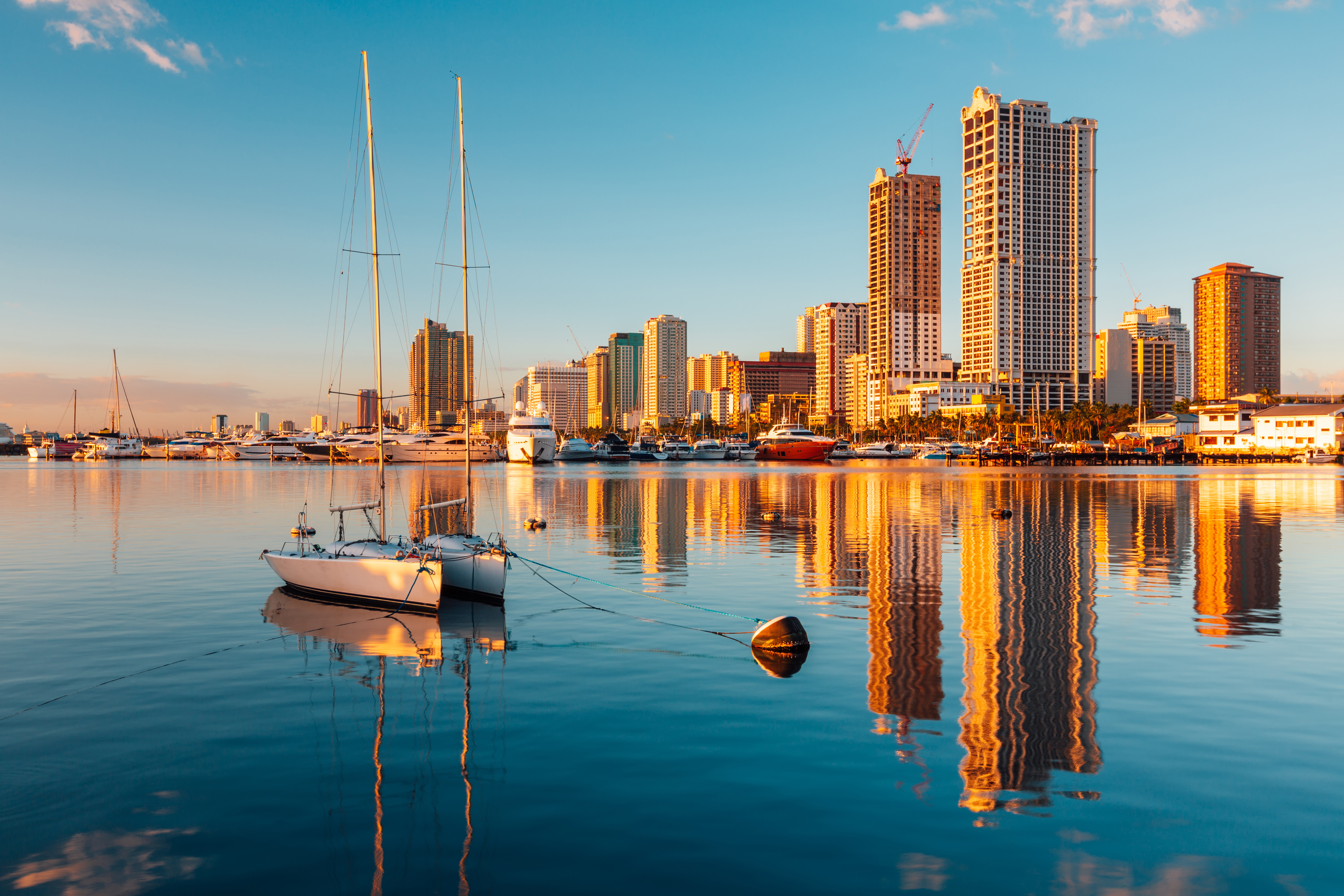
Manila’s buildings reflect its blend of cultural traditions, showing Malayan, Spanish, American, and Chinese influences. The residential houses in the districts of Ermita and Malate have Spanish and American styles of architecture. In downtown areas, impressive skyscrapers tower above the busy streets.
An acute housing problem exists. The majority of the people rent apartments or other homes, and some families own homes. The government provides housing loans for those who have the means to pay mortgages. The government has built housing to help the poor. However, the high cost of construction and the lack of space have resulted in many people living illegally on public land. Many people of limited means live in barong-barongs, shelters made of light materials with few modern conveniences. Barong-barongs are common in the heavily populated districts of Tondo and San Nicolas.
Education.
The city, with the help of the national government, provides free primary and secondary school education. There are also educational opportunities for children with disabilities, orphans, and adult students. The city maintains and runs the Pamantasang ng Lungsod ng Maynila (University of the City of Manila). Private educational institutions of higher learning are also available in Manila. Among these is the University of Santo Tomás, which was founded in 1611.
Cultural life and places to visit
The Cultural Center of the Philippines presents a wide variety of visual and performing arts, including painting and other artworks, concerts, plays, and dance performances. The center is located in a complex built on reclaimed land in Manila Bay. Among the major public buildings are the National Museum, which displays archaeological and natural history exhibits, and the National Library.
There are many recreational areas in Metro Manila. Rizal Park contains an open air theater, a playground, and a grandstand. The park also has a Japanese garden, a Chinese garden, and a long promenade along the shores of Manila Bay. The centerpiece of the park is a monument to the national hero José Rizal. Rizal was an early leader of the Philippine movement for political and social freedom from Spain. The Manila Zoological and Botanical Garden, the Paco Park, and the Mehan Garden are also located in the area. The Rizal Memorial Stadium and the Pope Pius XII Catholic Center provide sporting facilities. Private theaters, bowling alleys, and horse racetracks are also available.
Economy
Manila and its metropolitan area form the largest center of commerce, trade, and industry in the nation. The Asian Development Bank, which lends money to promote economic growth in Asia, has its headquarters in Manila. The headquarters of the Central Bank of the Philippines also is in the city. Commercial traders do business throughout the Philippines and with other countries. The city is an international port of entry. It lies on the air route and shipping lane from the United States to Asia. This location makes it a convenient distribution center for goods from different parts of the world. Most Philippine exports and imports pass through the ports of Manila.
Manufacturing
represents a small but significant part of the city’s economy. Leading industries produce beverages, chemicals, clothing, electronic products, machinery, processed foods, textiles, and tobacco products. Printing and publishing also contribute to the economy. Most factories are small. They are concentrated in the districts of Tondo, San Nicolas, Binondo, and Santa Cruz. There are heavier industries in Pandacan, Paco, and Santa Ana.
Service industries
employ the largest number of workers in Manila. Many people work in banking, communications, education, government, health care, real estate, sales, trade, and other such industries. Manila has some of the best health facilities in Asia. There are municipal hospitals and several health centers that offer free medical treatment for citizens. The national government also maintains hospitals in the city, including the Philippine General Hospital and the San Lazaro Hospital. Private hospitals and clinics are also available.
Transportation.
The main public transport is by jeepneys (decorated army jeeps), buses, and taxis. Bus services link Manila with northern and southern Luzon. Airlines use the nearby domestic and international airports. Philippine Airlines provides both domestic and international flights. The Philippine National Railways has its main terminal in Manila. It connects the city with other cities in Luzon. Traffic congestion is a major problem because of the rapid growth of the city and its population. The construction of the Manila Light Rail Transit and Manila Metro Rail Transit systems has provided some relief.
Manila is the Philippines’ busiest port for international and domestic shipping. The international port of entry is the South Harbour. The Customs House and several warehouses in South Harbour handle the loading and unloading of international goods. The North Harbour, in the district of Tondo, is the domestic port of entry. Many vessels from the Visayas and Mindanao islands enter Manila through the North Harbour.
Communication.
There are daily newspapers in both English and Filipino. The most important English dailies include The Manila Bulletin, The Philippine Star, and The Manila Times. Several radio broadcasting stations and television stations operate within Metro Manila.
Government
The city of Manila is part of the National Capital Region, which consists of the city’s metropolitan area. There are 16 cities and 1 municipality in Metro Manila. Each city or municipality has a mayor and legislative council elected by its people. The Metropolitan Manila Development Authority (MMDA) coordinates some services and developmental planning among the political units of the region. Manila and Quezon City are the largest of the cities.
Manila itself is governed by a mayor, a vice mayor, and a 36-member council. The voters of Manila elect all these officials. The mayor is the chief executive. Each city department has its own head. The City Council is in charge of legislative power and the levying of taxes. The Department of Justice supervises the prosecutor’s office. Metropolitan Trial Courts are under the supervision of the Supreme Court. There are six congressional districts. Each district has a member in the House of Representatives.
History
Manila and its bay have served as a trading port for more than a thousand years. Muslim traders began to visit some Philippine islands in the 1200’s. By the late 1500’s, some of the leaders and people in the Manila area had adopted Islam. When a Spanish expedition first visited the area in 1570, two Philippine Muslim rajahs, Soliman and Matanda, ruled an area of Manila south of the Pasig River. Rajah Lakandula ruled Tondo, then a separate village north of the river. The rich land around Manila attracted Miguel López de Legazpi, captain of the fifth Spanish expedition to the East. In 1571, the Spaniards conquered these rulers, and Legazpi founded a Spanish city at Manila.
Spanish rule.
Through a royal decree on June 10, 1574, King Philip II of Spain conferred on the City of Manila the title of Distinguished and Ever Loyal City. In 1595, Manila was declared the capital of the archipelago.
During Spanish rule, a wall enclosed the city, which was then known as Intramuros, or the Walled City. Outside the city were scattered villages. Each had its local chieftain and marketplace. The Spaniards founded several Roman Catholic churches, convents, and schools. The San Agustin Church in Intramuros, built between 1587 and 1607, is the oldest church in Manila. As the rule of the Spaniards grew stronger, they built churches and schools not only within the Walled City but also near the marketplaces outside. The churches and schools helped spread the Catholic faith. Manila then expanded outside the walls to take in the new churches. These early villages developed as centers of trade and settlement. Eventually, they became the present districts of Manila. 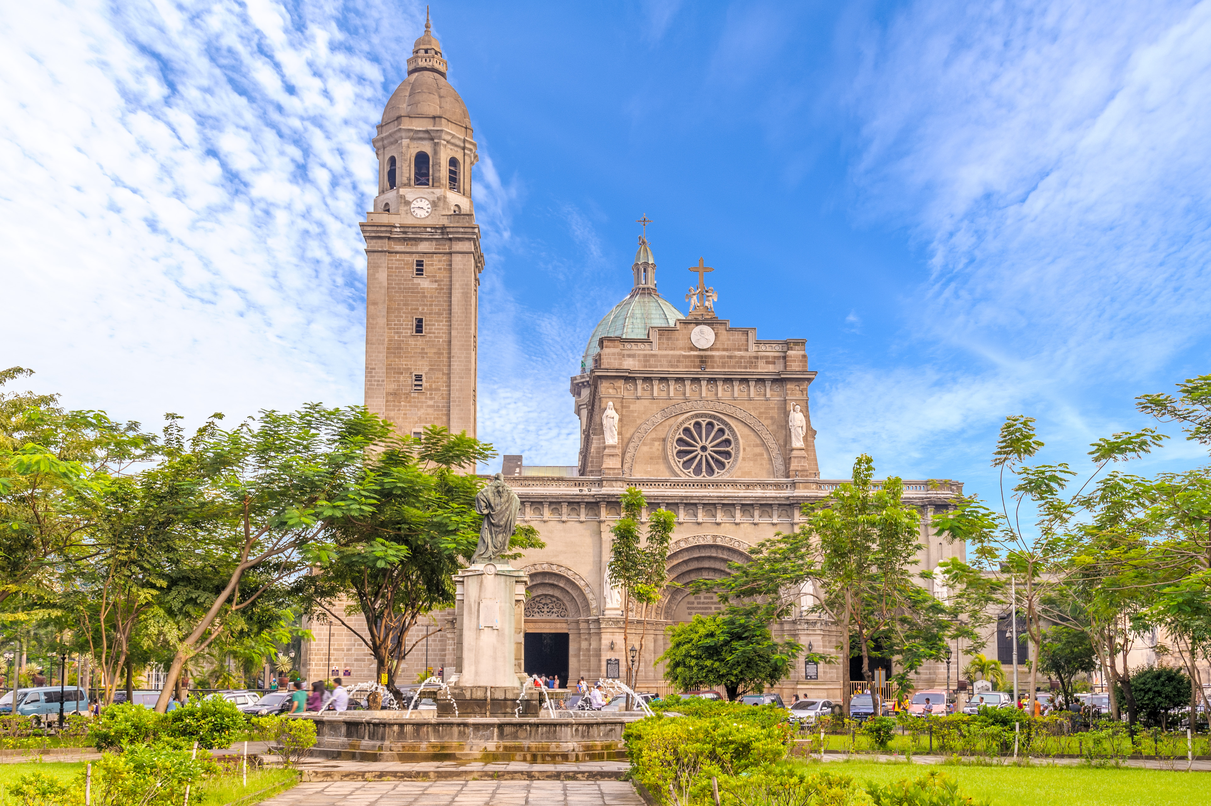
Manila developed into a major port in the Spanish Empire’s so-called galleon trade. Galleons were large sailing ships. Spanish galleons stopped at Manila on their voyages between the Spanish colony of New Spain, centered in Mexico, and China. They transported silver from New Spain to trade for Chinese silk, porcelain, jade, and other goods.
At various times during Spanish rule, Manila suffered serious problems. The Chinese staged rebellions in 1600, 1609, and 1645. Some Filipinos in other parts of the country also rebelled. The British occupied Manila from 1762 to 1764 during the Seven Years’ War (1756-1763). However, the British restored the city to Spain after the end of the war.
During the 1700’s and 1800’s, there was great progress in public building, transportation, communication, and commerce. The gates of Intramuros were constructed between 1781 and 1783. Spanish trade declined, but in the 1830’s, Manila was opened to foreign trade independent of Spanish control. The opening of the Suez Canal in 1869 improved commerce still further. The first telegraph line opened in 1872. The first railway line from Manila to Dagupan opened in the same year. The first system to provide drinkable water for city residents began operating in 1882.
Revolution to independence.
Manila was the birthplace of the Philippine Revolution. The revolution started in 1896 under the leadership of Andres Bonifacio. He organized a secret society called the Katipunan in his village near Manila. The governor general discovered the Katipunan, and fighting erupted in August. Manila was one of eight provinces that rebelled against Spain. The eight rays of the sun on the present national flag commemorate this event.
During the Spanish-American War (1898), an American fleet defeated the Spanish fleet in Manila Bay. American forces occupied the city and established a military government. In the peace treaty that ended the war, Spain turned over the Philippines to the United States. On July 31, 1901, the Philippine Commission passed a new charter to establish a civil government for the City of Manila, and American military rule ended on Aug. 7, 1901. The Philippines became a colony and later, from 1935, a commonwealth of the United States. Manila served as the capital.
During World War II (1939-1945), Japan invaded the Philippines on Dec. 8, 1941. Unable to hold the city, the armed forces of the Philippines and the United States attempted to save the city from destruction by withdrawing in late December and declaring Manila an open city (an undefended city open to the enemy). The Japanese occupied Manila in January 1942. In early 1945, the city was severely damaged during the bitter battle to recapture it. Manila was rebuilt with aid from the United States. It served as capital of the commonwealth until the Philippines became independent of the United States in 1946.
Center of government and growth.
Manila became the national capital of the Philippines when independence was proclaimed on July 4, 1946. In 1948, the Philippine government made Quezon City the official capital of the country. Manila continued to serve as the seat of the government, pending the completion of new government buildings in Quezon City. In 1976, the government made Manila the country’s official capital again. Metro Manila became the National Capital Region in 1978. Since the late 1900’s, the region has continued to experience rapid growth and economic development, as well as congestion and housing shortages.
