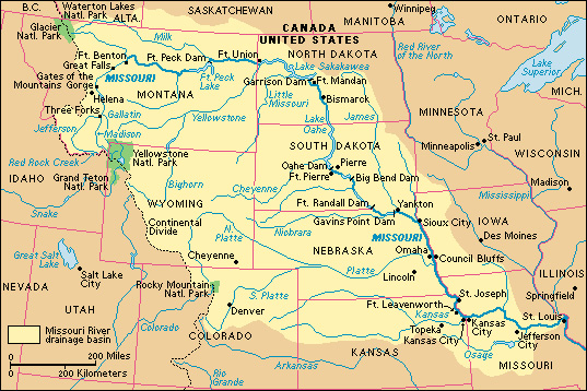
Missouri River is the longest river in the United States. It flows 2,540 miles (4,090 kilometers) from its source, Red Rock Creek in the Rocky Mountains in southwestern Montana, to its mouth on the Mississippi River. The Missouri drains an area of about 529,000 square miles (1,371,100 square kilometers). This drainage basin includes all or parts of 10 U.S. states and 2 Canadian provinces.

The Missouri has large amounts of mud in its water. Early explorers and Indians called it the Big Muddy, and farmers have described it as “too thick to drink and too thin to plow.” The source of the river’s name is unclear. The river may have been named after an Indian village called OueMessourit or Ou-Missouri located near its mouth. The village name means town of the large canoes.
The course of the Missouri.
The headwaters of the Missouri are at Red Rock Creek in the Rocky Mountains in southwestern Montana. Red Rock Creek eventually becomes the Jefferson River. At Three Forks, Montana, the Jefferson joins the Madison and Gallatin rivers to form the Missouri.
The Missouri flows north from Three Forks and cuts through a spectacular gorge called the Gates of the Mountains. Then it bends toward the northeast and plunges down a series of waterfalls known as the Great Falls of the Missouri. The city of Great Falls, Montana, at the head of the waterfalls, is named for these falls. From Great Falls, the Missouri winds eastward across Montana. In North Dakota, the river makes a great bend southward. Then it flows southeast across South Dakota.
The Missouri forms part of the boundary between South Dakota and Nebraska. It turns south at Sioux City, Iowa, and flows between Iowa and Nebraska. The river also forms the Nebraska-Missouri boundary and part of the Missouri-Kansas boundary. At Kansas City, Missouri, the river turns east again. It flows across Missouri and joins the Mississippi River about 20 miles (32 kilometers) north of downtown St. Louis. Every second, the Missouri empties an average of 76,300 cubic feet (2,161 cubic meters) of water into the Mississippi.
The Missouri, like most rivers, has an upper, middle, and lower part. The upper Missouri is a clear, rapid-flowing stream in the mountains of western Montana. The middle Missouri begins just below Great Falls, where the river leaves the mountains and moves onto the Great Plains. The middle Missouri is slower and muddier than the upper part. The lower Missouri is the slowest and muddiest part. It begins just downstream from Yankton, South Dakota, and extends to the Mississippi.
The Platte River is the longest branch of the Missouri. Other major tributaries include the James, Kansas, Milk, Osage, and Yellowstone rivers.
Navigation.
The Missouri River was once used for commercial navigation along most of its course. Today, almost all traffic upstream from Sioux City is recreational, but commercial activity thrives on the lower Missouri. The commercial river traffic is extremely important to farmers of the western part of the Midwest. It carries their goods to market and brings them fertilizer and other farm supplies. The chief ports on the river are Kansas City, Missouri; Omaha, Nebraska; and Sioux City.
Commercial traffic on the Missouri totals more than 31/4 million short tons (3.2 million metric tons) of freight yearly. Freight headed downstream consists mainly of such farm products as corn, sorghum, soybeans, and wheat. Upstream cargoes include benzine, cement, fertilizer, lime, paint, and phosphate. Most of the freight travels on barges pushed by powerful tugboats. A navigation channel at least 300 feet (91 meters) wide and 9 feet (2.7 meters) deep is maintained on the river between Sioux City and the Mississippi.
Dams and reservoirs.
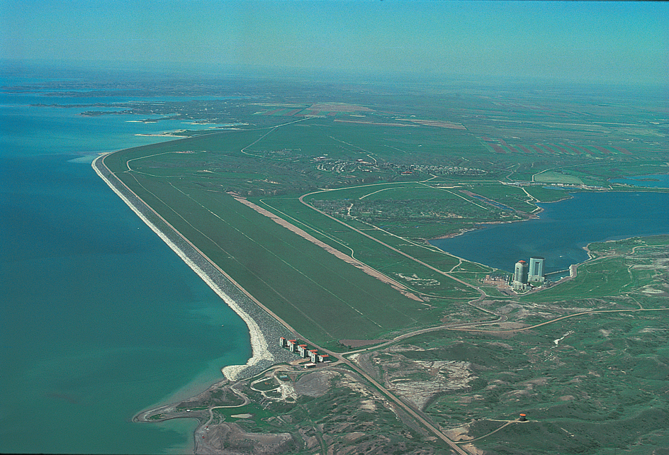
A series of six huge dams form a nearly continual chain of long, winding reservoirs along the middle Missouri River. These dams, in order from north to south along the river, are Fort Peck, Garrison, Oahe, Big Bend, Fort Randall, and Gavins Point. About 60 smaller dams and reservoirs are on tributaries of the Missouri. See Fort Peck Dam ; Fort Randall Dam ; Garrison Dam .

Flooding was once a serious problem on the Missouri. In spring, excess water from melting snow often caused the river to overflow, causing widespread damage. The six large dams on the middle Missouri have nearly eliminated this problem. The reservoirs of the dams store excess water in spring and gradually release it during the rest of the year, thus greatly reducing floods downstream.
The dams and their reservoirs also provide other services. Hydroelectric powerhouses at the dams generate electricity used by farms, homes, and industries throughout the middle Missouri Basin. Millions of visitors use the reservoirs annually for boating, fishing, swimming, and water skiing. Water from the reservoirs is also used to irrigate farmland and serve cities along the river.
Wildlife and conservation.
The Missouri and its valley provide a rich habitat for a wide variety of wildlife. Bears, deer, elk, moose, and other large animals live in the mountainous upper Missouri Valley. Smaller animals, such as beavers, foxes, muskrats, rabbits, skunks, and weasels, are common along the middle and lower parts of the river. Fishes of the cool, clear upper Missouri include graylings and rainbow trout. Bass, bullheads, catfish, carp, and perch inhabit the warmer, muddier waters below Great Falls.
The upper Missouri River flows through forests of fir, hemlock, and spruce trees. The middle and lower sections of the river wind through grasslands. Forests of cottonwoods, hickories, oaks, poplars, and willows also lie along the middle and lower sections of the Missouri.
At one time, pollution threatened much of the wildlife along the Missouri. Pesticides and other chemicals used by farmers were washed into the river, and industries dumped wastes into it. These substances poisoned fish and other wildlife. Today, federal laws ban certain pesticides, and industrial discharges into the river are carefully controlled. As a result, the quality of the water is gradually improving.
History.
The Missouri River was formed about 20 million years ago, during the Miocene Epoch. During the Pleistocene Epoch, a time marked by a succession of ice ages which ended about 11,500 years ago, the river marked the southern and western edge of many of the huge ice sheets that covered the land.
The Missouri River Basin was the home of several Indian tribes. The Wind River Shoshone and the Gros Ventre (also called Atsina) lived near the headwaters of the river, in western Montana. Several buffalo-hunting tribes occupied the Missouri Basin between eastern Montana and the Mississippi. They included the Arikara, the Assiniboine, the Dakotah (Sioux), the Hidatsa, the Kansa, the Missouri, and the Omaha. Many of these tribes spent much of their time on the grasslands away from the river. But the Missouri was a valuable water source, a favorite hunting ground, and an important route for their canoes.
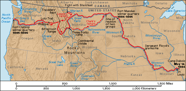
The first whites to see the Missouri River were the explorers Jacques Marquette of France and Louis Jolliet, a French Canadian. They reached the mouth of the Missouri in 1673 while exploring the Mississippi. The United States bought the Missouri River Basin from France in 1803 as part of the Louisiana Purchase. From 1804 to 1806, two Americans, Meriwether Lewis and William Clark, explored the territory drained by the Missouri. See Lewis and Clark expedition .

During the early 1800’s, the Missouri became one of the main transportation routes of the fur trade in the West. At first, keelboats hauled furs and supplies on the river. Steamboat traffic began on the Missouri in 1819, and steamers soon became the chief means of transportation. Many pioneers who traveled west in the mid-1800’s went at least part of the way on a Missouri steamer. Traffic on the Missouri declined after railroads were built in the West during the late 1800’s. But today, the lower Missouri River is an important commercial waterway.
Major floods struck along the Missouri River in 1943, 1947, 1951, 1952, and 1993. But the six huge dams on the middle Missouri and the smaller dams on the Missouri’s tributaries have greatly reduced the threat of disastrous flooding. These dams make up the heart of the Pick-Sloan Missouri Basin Program. This program, which was authorized by Congress in 1944, is a flood control, electric power, and irrigation project. Under the program, 39 dams were constructed on the Missouri and its tributaries by the beginning of the 2000’s.
