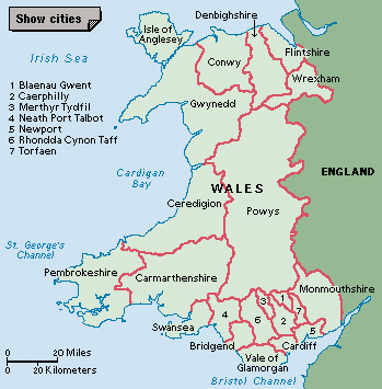
Monmouthshire (pop. 92,527) is a local government area in South Wales in the United Kingdom. It is a unitary authority established in 1996, responsible for all local government services within its boundaries. From 1974 to 1996, the present area of Monmouthshire was part of a county called Gwent. The Welsh name of the area is Sir Fynwy.

Monmouthshire is bounded to the east by the English counties of Herefordshire and Gloucestershire, and to the south by the estuary of the River Severn. Monmouthshire is a rural area dependent on dairy and sheep farming and tourism and other service industries. The northwest of the region is part of the Brecon Beacons National Park, and the eastern border comes within the Wye Valley Area of Outstanding Natural Beauty. The rivers Usk and Wye flow through the region. The levels (wetlands) along the boundary with the River Severn form an internationally famous Site of Special Scientific Interest (SSSI).
Monmouthshire County Council, the authority’s administrative body, has its head offices in Cwmbran, in neighboring Torfaen. The most important towns within the Monmouthshire area are the historic market towns of Abergavenny, Chepstow, Caldicot, and Monmouth.
The Romans built military forts in Monmouth, Usk, and Abergavenny and a civil settlement in Caerwent (Venta Silurum) between A.D. 50 and 100. In the late 1000’s and 1100’s, the Normans built castles in Abergavenny, Monmouth, Usk, and Chepstow (Striguil). At about the same time, monasteries developed in Tintern and Llanthony.
In the 1400’s, Harry of Monmouth (later King Henry V of England) helped suppress the rebellion of Owen Glendower (Owain Glyn Dwr). A castle was built in Raglan during the 1400’s.
In 1536, the county of Monmouthshire, with larger dimensions than the present unitary authority area, came into official existence as a county of England, not Wales. It was finally recognized as a Welsh county in 1968.
See also Newport; Blaenau Gwent.
