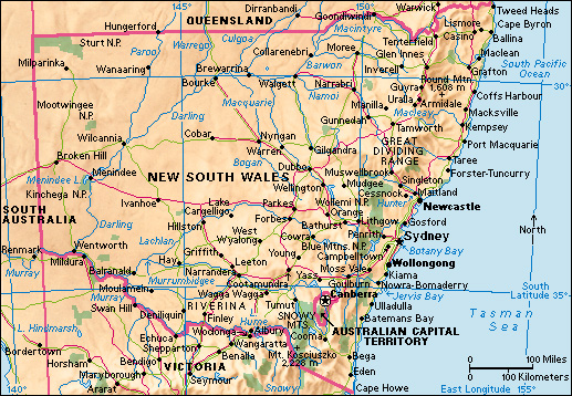
New South Wales is the largest Australian state in terms of population. It occupies much of the southeast of the Australian continent. The state borders Queensland to the north, the Pacific Ocean to the east, Victoria to the south, and South Australia to the west. Sydney is the state’s capital and largest city. Newcastle and Wollongong are other major cities.
The state flower of New South Wales is the waratah. This shrub has a striking red flower. It grows in the sandstone region around Sydney. The climate of New South Wales is generally mild and sunny.
The British navigator James Cook sighted the eastern coast of Australia in 1770. He named the area New South Wales because he thought the land looked like southern Wales. New South Wales assumed roughly its present boundaries in 1863. In 1901, it and the other colonies in Australia became states when they united to form the Commonwealth of Australia.
People
Population.
About a third of Australia’s population lives in New South Wales. The majority of the state’s people were born in Australia and are of British or Irish descent. However, many people from Germany, Greece, Italy, the former Yugoslavia, and other European countries have migrated to New South Wales since World War II (1939-1945). In addition, many Asian immigrants have arrived since the 1970’s, primarily from China, Nepal, the Philippines, South Korea, and Vietnam. There are also many immigrants from New Zealand and Lebanon. About 278,000 people in the state have Aboriginal or Torres Strait Islander ancestry.
The majority of the population of New South Wales lives on the coast, and coastal areas remain the fastest growing. The state government has tried to decentralize the population by encouraging people to live in inland centers, such as Bathurst-Orange and Albury-Wodonga. But these attempts have been largely unsuccessful. About two-thirds of the state’s population lives in or near Sydney.
Schools.
In New South Wales, children must begin school at the age of 6 and must complete 10 grades. The state’s Department of Education provides free primary and secondary education. Most students begin school in kindergarten at age 5 and continue through the 12th grade at the age of 17 or 18. Primary school covers seven years—from kindergarten to sixth grade. Secondary school, or high school, covers the six years from grades 7 to 12. Those leaving school before age 17 must enroll in vocational education or training, or work full time.
The majority of children attend government schools, but there is also a strong private school system, particularly at the secondary school level. Religious organizations, primarily the Roman Catholic Church, operate most private schools. The state also provides special schools for children with disabilities and distance learning facilities for those living too far from their nearest school.
Students are eligible for the Record of School Achievement at the end of 10th grade and the Higher School Certificate at the end of 12th grade. Employment opportunities and entry into universities and colleges are largely based on the results students achieve in their Higher School Certificate examination.
As in other states, the main institution for higher education in New South Wales is the TAFE (Technical and Further Education) system, which primarily provides vocational education. TAFE colleges are located throughout the state. There are also 11 universities in New South Wales. Six are in Sydney: the University of Sydney; the University of New South Wales; the University of Technology, Sydney; Western Sydney University; Australian Catholic University; and Macquarie University. Charles Sturt University and the Southern Cross University are in inland areas of the state. Other universities are the University of Wollongong, the University of Newcastle, and the University of New England, in Armidale. Specialized forms of higher education are offered at the state’s armed forces training establishments and theological colleges. The Australian Film Television and Radio School and the National Institute of Dramatic Art (NIDA) both have their main facilities in Sydney.
Land and climate
New South Wales occupies about 10 percent of the total land area of Australia. The state stretches 683 miles (1,099 kilometers) along the Tasman Sea, from Point Danger in the north to Cape Howe in the south. The total length of the coastline is 1,180 miles (1,900 kilometers). The state is about 850 miles (1,370 kilometers) wide at its widest point.
Land regions.
New South Wales can be divided into six primary land regions. They are (1) the Coastal Belt, (2) the Mountains and Tablelands Region, (3) the Slopes and Plains Region, (4) the Lower Darling Basin, (5) the Murray Basin Slopes, and (6) the Riverina.
Most people in New South Wales live in the Coastal Belt. The coast consists of many rugged cliffs. Some of these cliffs form rocky headlands that enclose good harbors. Sandy beaches line much of the coast. The Mountains and Tablelands Region, the Slopes and Plains Region, the Murray Basin Slopes, and the Riverina are important farming areas. The Lower Darling Basin is a dry area in the west of the state.
In addition to the six main regions, the Darling Downs and the Channel Country regions extend from Queensland into western New South Wales. The western fringe of the state can be classified as part of the Central Desert Area.
The Coastal Belt
includes the North Coast. This narrow strip of land, between Taree and the Queensland border, is crossed by a number of large rivers. The area has many large dairy and beef cattle farms. Forestry and the production of sugar cane and tropical fruit are also important. To the south lies the Hunter Valley, an area of fertile land that lies on both sides of the Hunter River. Many dairy farms are in this area. Beef cattle are raised along the hills and ridges at the edges of the valley. The Hunter Valley is well known for cultivation of grapes and production of fine red and white table wines. Vegetables are grown around Maitland. The Hunter Valley is also an important coal-mining area.
The Sydney region, on the Coastal Belt, is bordered on the north by the Hunter Valley and on the south by the South Coast. The western boundary is formed by the eastern slopes of the Blue Mountains. The South Coast extends south from Sydney to the Victoria border. Most of this region is devoted to dairy farms, or to forests, which are grown for timber.
The Mountains and Tablelands Region
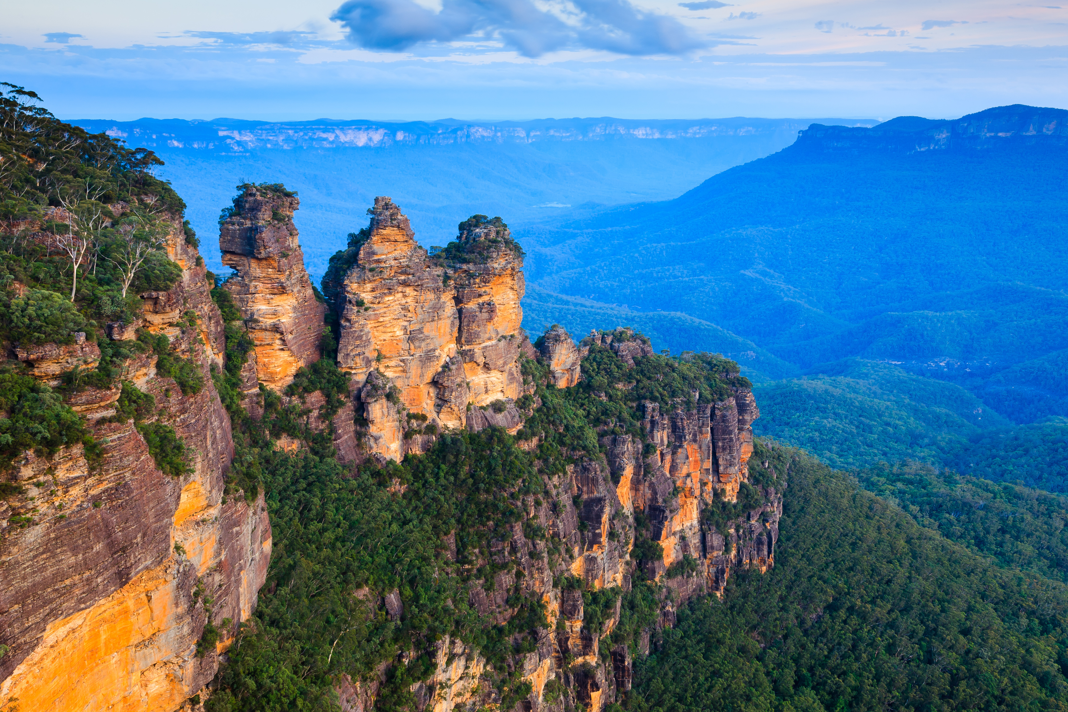
extends from the McPherson Range in the north to the Snowy Mountains in the south. This region includes New England, which is the largest highland area in the state. The tablelands stretch north to the Queensland border from an area south of Tamworth. Vegetation in the region varies greatly, from the wooded hill country, where forestry is important, to the rich soil of the cultivated valleys. Farming, sheep and cattle raising, and fruit growing are important activities.
The region’s Central Uplands consist of a raised plateau of the Great Dividing Range. This area includes hill country and open river plains. Farms in this area produce much wool and also grow such crops as oats and wheat. Around Orange, where there are rich, red, volcanic soils, much fruit is produced.
The Southern Tablelands is an upland area that includes Canberra and the Australian Capital Territory. It extends south from around Mittagong to the eastern side of the Snowy Mountains.
The Australian Alps is an area of broad uplands and mountain peaks in southern New South Wales. In this region, Australia’s highest peak, Mount Kosciuszko, rises 7,310 feet (2,228 meters) above sea level. The Murray River rises close to Mount Kosciuszko.
The Slopes and Plains Region
includes the North West Slopes. This area stretches from Goondiwindi on the Queensland border south to the area around Dubbo and Wellington. It is bounded to the east by the western side of the Liverpool Range. It includes the volcanic region of the Warrumbungle and the Nandewar Range.
The Lower Darling Basin
area comprises the arid plains bordering the Darling River between Wilcannia in the north and Wentworth in the south.
The Murray Basin Slopes
are the southern part of the sheep and wheat areas of the southeast. The slopes stretch from Dubbo on the Macquarie River in the north to Albury on the Murray River in the south.
The Riverina
is a flat area that forms part of the Murray Basin. The Murrumbidgee Irrigation Area and the Coleambally Irrigation Area supply water for fruit growing and for crop and animal farming. The area around Griffith is known for growing rice and vegetables and for the production of wine.
Rivers and lakes.
New South Wales has few lakes. The Blue Lake and Lake May are in the Australian Alps. Lake George, the largest freshwater lake in New South Wales, is near Canberra. Many lakes in the interior dry up during droughts. These lakes fill when the rivers flood in the wet season. For example, Lake Cowal near Forbes fills when the Lachlan River floods.
The largest river system in New South Wales is that of the Murray and Darling rivers. The main tributaries of this system are the Murrumbidgee, the Lachlan, and the Macquarie. The Hunter River is the largest river that flows eastward to the sea on the New South Wales coast. It is 287 miles (462 kilometers) long. Other important coastal rivers are the Clarence, Hawkesbury, Macleay, Manning, Richmond, Shoalhaven, and Tweed.
Climate.
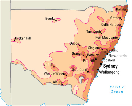
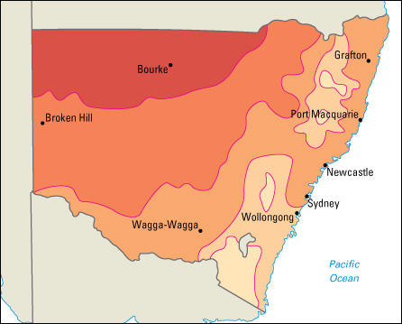
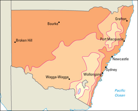
The climate of New South Wales is mild and sunny for the most part, because the state lies in the temperate zone. But extremes of heat and cold do occur. Temperatures average about 50 °F (10 °C) in July and 75 °F (24 °C) in January. In the hot, dry areas of the state, such as Cobar, White Cliffs, and Wilcannia, summer temperatures of up to 120 °F (49 °C) have been recorded. Average annual rainfall in the state ranges from 80 inches (200 centimeters) in the eastern highlands to less than 10 inches (25 centimeters) on the western plains. Sydney has a pleasant climate. The average winter temperature of the inner city of Sydney is about 55 °F (13 °C), and the average summer temperature is about 72 °F (22 °C). The city receives about 43 inches (110 centimeters) of rain a year. 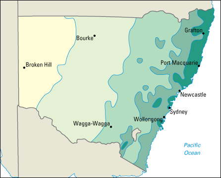
Economy
New South Wales has the most diverse economy in Australia. Service industries make up the largest sector of the economy. Sydney is a major center for finance and insurance, manufacturing, and trade. Agriculture and mining also contribute to the state’s economy. The state has about one-third of Australia’s work force.
Natural resources.
The soils of New South Wales may be divided into three groups—humid soils, subhumid soils, and semiarid soils. Humid soils are found in the coastal and some tableland areas. Humid soils include the rich alluvial soils of the river valleys and the red loams of the higher ground. Alluvial soils consist of sand, silt, or mud left by flowing water. Loams are between sandy soil and clay soil in texture and are generally mixtures of sand, clay, and silt.
Subhumid soils are found in the great wheat- and cotton-growing areas, such as the Liverpool Ranges and areas to the north. Semiarid soils are found in much of the interior. They can be either brown, light soils in the summer rainfall areas of the northern part of the state, or the heavier brown and gray soils found in the south, including the Riverina area. In the far western districts, much of the soil is extremely poor.
Water in New South Wales, as in the rest of Australia, is not abundant because of the low average rainfall. Farmers in the drier parts of the state dig artesian wells to tap water for their sheep and cattle. Artesian water is ground water that is under great pressure and can be brought to the surface simply by digging wells. This water is too salty to be useful for irrigation. Part of the vast underground Great Artesian Basin lies in the state.
Forests cover about one-fourth of the area of the state. Most of this forested land is old growth rather than plantation forest. There is increasing controversy over continued logging and wood chip extraction in these areas.
Power and irrigation projects.
Rainfall is low and unreliable in a wide area of the state. For this reason, water conservation is extremely important. Snowy Hydro Limited, formerly known as the Snowy Mountains Hydro-electric Authority, controls a huge hydroelectric and irrigation project. The state government has built large dams in many areas.
The Snowy Mountains Scheme
combines a huge hydroelectric plan with an irrigation project. The purpose of this scheme is to transfer and store the inland river system waters that would normally flow unused to the sea. See Snowy Mountains Scheme.
The Murray River Area.
Water for the Murray Valley Irrigation Area is stored in the Hume Reservoir, near Albury.
The Murrumbidgee Irrigation Area
has as its main storage facilities Blowering Dam, near Tumut, and Burrinjuck Dam, near Yass. Water stored in the Blowering Dam comes from the Tumut River and water released from the Snowy Mountains Scheme.
The Coleambally Irrigation Area
is a project in the Riverina. The Gogeldrie Weir, near Narrandera, diverts water from the Murrumbidgee River to be used for intensive cultivation in this area.
The Lachlan River Irrigation System
has the Wyangala Dam, upstream from Cowra, as its chief storage dam. Storage dams at Lake Cargelligo and Lake Brewster conserve water during flooding of the Lachlan River.
Other major irrigation projects.
The Burrendong Dam on the Macquarie River lies near Wellington and supplies water to the area. The Glenbawn Dam in the Hunter Valley was built both to store water for irrigation and to help in the control of floods in the area. The Keepit Dam in the Namoi River Scheme has made intensive irrigation possible. Because of the dam, farmers in the Namoi Valley can grow cotton. Another dam is the Copeton Dam on the Gwydir River, near Inverell. The Warragamba Dam on the Wollondilly River is the main source of Sydney’s water supply.
Service industries
are industries that provide services rather than produce goods. They contribute about 80 percent of the New South Wales gross state product (GSP) each year. The GSP is the value of all goods and services produced in the state in a year. About 80 percent of the state’s workers are employed in service industries. Sydney is a major center for finance and insurance in the Asia-Pacific region. Property and business services, including information technology services, are a growing sector of the economy. Other important service industries in the state include education, government services, health and community services, and wholesale and retail trade. Hotels and restaurants benefit from the tens of millions of tourists who visit the state each year.
Manufacturing.
New South Wales accounts for about 30 percent of the manufacturing activity in Australia. The sector employs about 10 percent of the state’s work force and makes up nearly 10 percent of the annual GSP. Sydney is the state’s largest industrial city. Newcastle and Wollongong are also important manufacturing centers. The leading manufactured goods include fabricated metal products, iron and steel, machinery, paper, pharmaceuticals (medicinal drugs), printed materials, processed foods, and wood products.
Agriculture.
Farmland lies on the coastal plain, in the foothills of the Great Dividing Range, and on the plains west of the mountains. Irrigation systems supply water to many inland areas.
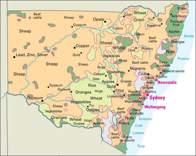
Grazing is an important part of the state’s rural income. Beef cattle are the leading livestock product. The main beef cattle areas are in the northern and northwestern parts of the state. About a third of Australia’s sheep are raised in New South Wales. Many farms in the state are involved in raising sheep, either for meat or wool. 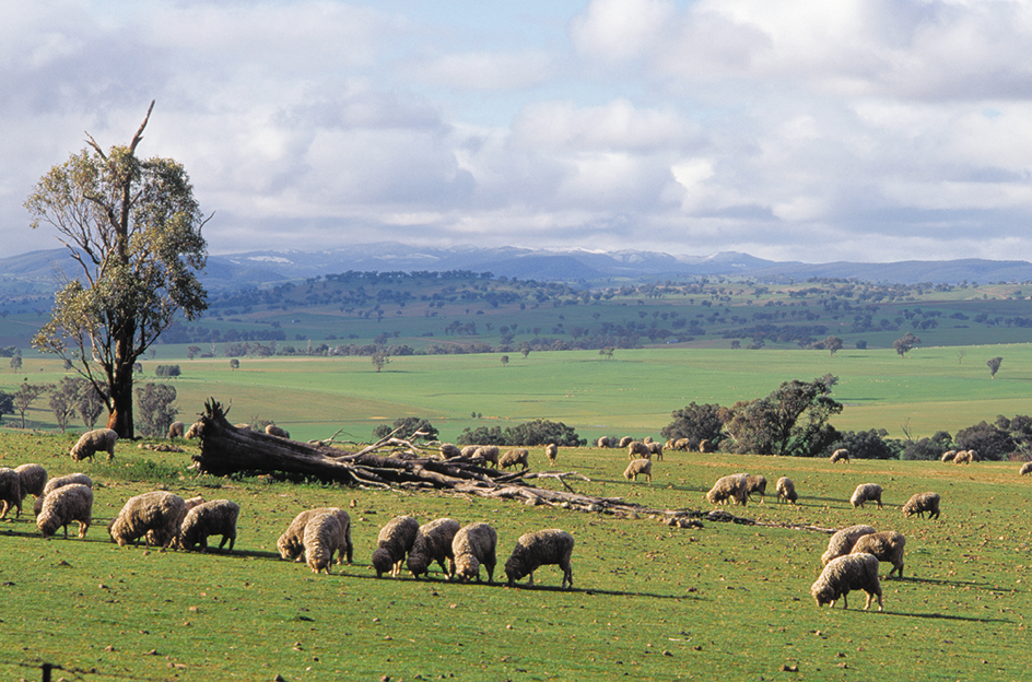
Hogs are mainly raised on large, intensive farms called piggeries. Poultry are raised for their meat and eggs, mainly in areas close to the major cities. Most dairy farmers in the state have farms on flat land near rivers. Most dairy farms are on the eastern coast.
Wheat is the main crop grown in New South Wales. It accounts for about a fourth of Australia’s total wheat production. Most wheat farmers also grow other crops. The state’s other cereal crops include barley, oats, rice, and sorghum, and to a lesser extent triticale (a grain produced by crossing wheat and rye) and corn. Most of Australia’s cotton is cultivated in New South Wales, mainly along the banks of the Barwon, Darling, Gwydir, Macintyre, Macquarie, and Namoi rivers. Farmers in northern New South Wales grow much sugar cane. The Murrumbidgee area of New South Wales produces most of the country’s rice. Cotton, sugar, and rice production is largely dependent upon the state’s extensive irrigation systems. 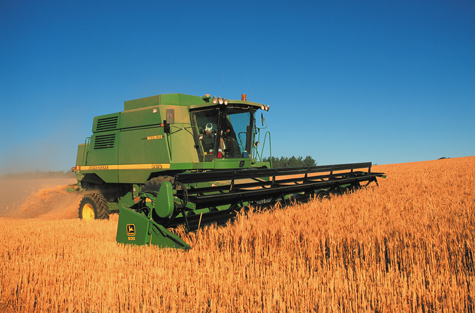
The Murray and Murrumbidgee irrigation areas in southern New South Wales are important fruit-growing regions. These areas produce apples, citrus fruits, and grapes. Fruit growers in the northern coastal districts of the state grow such tropical fruits as bananas and pineapples. Vegetables are mainly grown in the coastal areas of the state and in the Murrumbidgee and Murray areas under irrigation. The state’s main vegetables include lettuce, mushrooms, potatoes, and tomatoes. The Hunter Valley area north of Sydney is well known for grapes grown for the Australian wine industry. Its wineries are major tourism attractions.
Fishing
is an important industry in New South Wales. There are rich fishing areas along the entire coast of the state. Bream, mullet, salmon, snapper, and whiting are some of the fish caught commercially. Important shellfish include crabs, lobster, and prawns. Raising oysters on fish farms is a major economic activity. Recreational fishing is also popular.
Mining.
Coal ranks as the state’s leading mining product. Huge deposits of black coal are mined in the northeastern part of New South Wales. New South Wales produces over a third of the black coal mined in Australia.
Australia’s first gold discovery was made in New South Wales in 1851. Other important products mined in the state include copper, lead, limestone, mineral sands, opals, rutile, silver, and zinc. Much of the copper, gold, lead, silver, and zinc is mined near Broken Hill, Cobar, and Orange.
Transportation.
The state has five main highways. The Hume Highway and the Princes Highway link Sydney with Melbourne. The Pacific Highway and the New England Highway link Sydney with Brisbane. The Great Western Highway extends west from Sydney to Bathurst, where motorists can take the Sturt Highway to the border town of Wentworth, or the Mitchell and Barrier highways to Broken Hill.
The state has five main railroad lines. The Illawarra line runs along the coast between Sydney and Nowra. The southern line runs between Sydney and Melbourne. The western line links Sydney with the cities of western New South Wales, such as Bathurst and Broken Hill. The northern line was the first to connect Sydney and Brisbane. The north coast line links Sydney with towns in northern New South Wales on the way to Brisbane.
Sydney has an international airport. A network of air services links many towns and cities within the state. Good ports and harbors exist along the whole coast. The ports of Sydney, Newcastle, and Port Kembla handle ships from other states and from other countries.
Government
The government of New South Wales consists of the state Parliament and a representative of the British monarch, the governor. The state Parliament has most of the governing power.
The state government in New South Wales is responsible for managing the state’s finances and providing a range of services, including health, education, public transportation, and law and order. The government also supports agricultural development and urban and regional development.
Legislature.
The state Parliament has two houses. The upper house, called the Legislative Council, has 42 members. The lower house, called the Legislative Assembly, has 93 members. Members of the Legislative Council are elected to eight-year terms by all the voters of the state as a whole. Members of the Legislative Assembly each represent one electoral district and are elected by the people of that district to four-year terms.
The Legislative Assembly has full powers of legislation, including the introduction of taxation and government spending measures. Most of the laws passed by Parliament originate in this house. The Legislative Council acts mainly as a house of review. Its members discuss and review measures that have already been passed by the Assembly. The Council cannot introduce or amend money measures. When bills have been passed through both houses, they are sent to the governor for signature, called the Royal Assent, before they become law.
Executive.
The British Crown, on the advice of the New South Wales government, appoints the governor as the chief executive for the state. This position is largely ceremonial, however. Most executive power is exercised by the party or coalition that wins the majority of seats in the Legislative Assembly. Assembly members from the winning party or coalition form the government and select a leader, called the premier. The premier is the actual head of government. The premier is assisted by a Cabinet of ministers, who head government departments. The Cabinet normally decides on new legislation, which is introduced into Parliament by the responsible minister.
Voting.
In New South Wales, as in the rest of the country, all citizens 18 years of age or older must vote. Both state and federal candidates are elected through preferential voting, which allows voters to rank candidates in order of preference. See Preferential voting.
Local government
is the responsibility of New South Wales’s local councils and county councils. The local councils govern the cities, shires, and other local government areas of the state. Councilors are elected by the adult taxpayers and residents of each local area. The functions of local councils include maintenance of some roads and bridges, drainage, building control, community welfare, waste disposal, and provision and maintenance of local parks and gardens. County councils are specialized councils that generally have only one or two functions, such as weed elimination or flood-plain control.
History
Aboriginal peoples
have lived in New South Wales for at least 50,000 years. Scientists have discovered human remains and early stone tools that are approximately 40,000 to 50,000 years old at Lake Mungo, one of the most important archaeological sites in Australia.
Over time, Aboriginal people in New South Wales developed a variety of ways to use the region’s resources. They fished, hunted, and gathered plants. Eventually, some groups began to live in semi-permanent villages, though they still may have moved about in search of resources or in response to such environmental conditions as drought. Some groups used fire to clear sections of land in order to encourage the growth of useful plants and to create grasslands to attract animals for hunting. This technique is called firestick farming. Evidence of Aboriginal fish traps made up of a system of channels, dams, and holding pools exists along the Barwon River. The Aboriginal peoples of New South Wales belonged to many different clans, each with its own language, cultural practices, and territory.
European settlement.
The first European to sight the part of Australia now called New South Wales was the British navigator James Cook. He and his crew aboard the Endeavour sailed along most of the eastern coast in 1770 and landed briefly at Botany Bay. Cook gave New South Wales its name.
In the late 1700’s, British prisons were overcrowded. The British government decided to send a group of convicts, with Royal Marines as guards, to form a settlement at Botany Bay. Officials also hoped that the colony would serve as an outpost for shipping and trade in the Pacific region. See Convicts in Australia.
In May 1787, the First Fleet set out from England on its long voyage. The man in charge of the ships, Marines, and convicts was Arthur Phillip. He became the first governor of New South Wales. 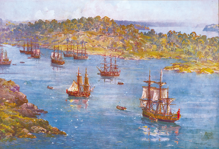
When Phillip reached Botany Bay, he found it unsuitable for a settlement. He then sailed a few miles to the north and found a safe harbor at Port Jackson. The deep water allowed the ships to anchor close to the shore. Phillip’s men also found a source of fresh water, a small stream called the Tank Stream. It flowed into a bay now called Sydney Cove. Here, on Jan. 26, 1788, the new colony of New South Wales was set up. The settlement at Port Jackson was the first European settlement in Australia.
At that time, New South Wales was the name used for the eastern part of Australia and included land that is now part of the states of Queensland, Victoria, and part of South Australia. The British settlement established on Van Diemen’s Land (later renamed Tasmania) in 1803 was part of New South Wales before becoming a separate colony in 1825. South Australia became a separate colony in 1836; Victoria, in 1851; and Queensland, in 1859. Administration of what became the Northern Territory was transferred from New South Wales to South Australia in 1863.
The first European colonists had many difficulties. They found that the poor, sandy soil around the settlement would not produce crops easily. They did not have enough fresh water and food. They did not have enough tools, and the ones they had were of poor quality. Despite these difficulties, Phillip believed in a bright future for the new colony.
The worst problem, lack of food, was not solved until better soil was discovered in the Hawkesbury River Valley. A settlement was established there, in 1794, on the present site of Windsor. James Ruse, a convict, was among the first of these settlers. He had successfully operated a farm at the original settlement in 1791 and received the colony’s first land grant.
Convict life.
When the convicts arrived in Sydney, they were made to labor on government works, or they were assigned to work for free settlers or officers. Convicts who broke the law in the new settlement were handled harshly. Some were flogged. Others were sent to more severe penal settlements, such as Norfolk Island, where they were forced to work in chains.
A woman convict, if married to another convict, could stay with him. Otherwise, she was often sent to work as a servant for a free settler. A woman convict could also be employed at the Female Factory at Parramatta, where conditions were bad.
If convicts were highly skilled or well-behaved, they were given a ticket-of-leave. The ticket-of-leave represented a form of parole that allowed them to live and work as free people. However, they could not leave the colony. The governor could also pardon convicts before they had served their full sentences. Pardoned convicts were called emancipists.
If they were lucky, convicts could have fairly good lives. If they were unlucky enough to have a harsh master, or if they were reconvicted, they could be cruelly treated.
The New South Wales Corps.
The Royal Marines were unhappy in the colony. As a result, a special army regiment was formed in Britain (now the United Kingdom) and sent to New South Wales to occupy the colony. This regiment was the New South Wales Corps. The officers were given grants of land and allowed to use convict labor to develop farms. Ordinary soldiers, if they retired in the colony after completing their terms of service, were also given land.
The colony was generally peaceful, and as a result, the soldiers did not have much to do. The officers became more interested in making their own fortunes. They operated their farms and engaged in trading. They formed groups and bought entire cargoes from the ships that came to Sydney. The officers sold these goods to other colonists at a high profit. Rum and other alcoholic spirits were popular and profitable. The trade in rum created many problems. When the governors tried to stop the trade, the officers opposed them. In 1808, the officers led a mutiny against Governor William Bligh and took over the government. This action caused the end of the New South Wales Corps. It was recalled to the United Kingdom. See Rum Rebellion.
Growth of the colony.
A new era began with the arrival of Governor Lachlan Macquarie in 1810. Macquarie was one of the most successful governors of New South Wales. Under his guidance, the colony developed and prospered. Macquarie encouraged exploration, and in 1813, the barrier of the Blue Mountains was crossed by Gregory Blaxland, William Lawson, and William Charles Wentworth.
Whales were plentiful in Australian waters. A profitable whaling industry, mainly involving British and American ships, developed in the late 1700’s and early 1800’s. In 1805, Sydney merchants built the first Australian whaling ship. By 1835, Sydney was the base for 76 whalers.
The growth of sheep raising resulted in more exploration because the sheep growers required more and more pastureland. The main explorers were John Oxley, Charles Sturt, and Sir Thomas Mitchell.
Cedar timber was a popular building material. By 1804, convicts were cutting cedar logs on the banks of the Hunter River. Bullock teams hauled logs to the river. The logs were lashed together to form rafts and floated downriver to a timber yard. The cedar harvesters went farther and farther north from Sydney. By about 1830, they had reached the Macleay River. By the 1890’s, cedar had almost vanished from the eastern coast of Australia.
The Aboriginal population was greatly reduced by European diseases, violent conflicts with the settlers, and the loss of traditional food and resources. In one of the most well known cases of violence, known as the Myall Creek Massacre, European cattle workers killed 28 men, women, and children at Myall Creek farm in 1838. After a controversial trial, seven Europeans were hanged for the murders.
Free settlers began to arrive in the early 1800’s. Convict immigration to New South Wales ended in 1840, though it was revived briefly in 1848 and 1849. The free settlers did not like the fact that the governor had been given wide powers when New South Wales was set up as a prison colony. They wanted more freedom. Their leader was William Charles Wentworth, who had been a member of the expedition that had first crossed the Blue Mountains. Later, he became a lawyer, newspaper owner, and rancher. Wentworth wanted more representation in government for the citizens. The fight for self-government in New South Wales was largely won through his efforts.
Self-government.
In 1823, a small Legislative Council was set up to advise the governor on the laws he proposed to make for the colony. In 1842, this council was enlarged, and some of its members were elected by the people. Finally, in 1851, all the Australian colonies were given the right to govern themselves in most matters. They were allowed to set up their own parliaments. In 1856, New South Wales became completely self-governing, and the first New South Wales Parliament met. Sir Stuart Donaldson was the first premier.
In 1851, John Lister and three brothers—William, James, and Henry Tom—made the first major discovery of gold in Australia near Bathurst. Gold had been found before, but this time a rush to Bathurst took place. Many people left their work and went to the diggings. Many thousands of people migrated to Australia in search of gold. Many settled permanently in Australia.
In 1889, Sir Henry Parkes, then premier of New South Wales, urged that the six Australian colonies should join together to form a federal union. The union was finally proclaimed on Jan. 1, 1901, at Centennial Park in Sydney. New South Wales became one of the six states of the new Commonwealth of Australia. See Federation of Australia.
In 1911, the state began a transfer of land to the federal government to form the Australian Capital Territory, which covers 911 square miles (2,359 square kilometers). Canberra, the national capital, is in the territory. 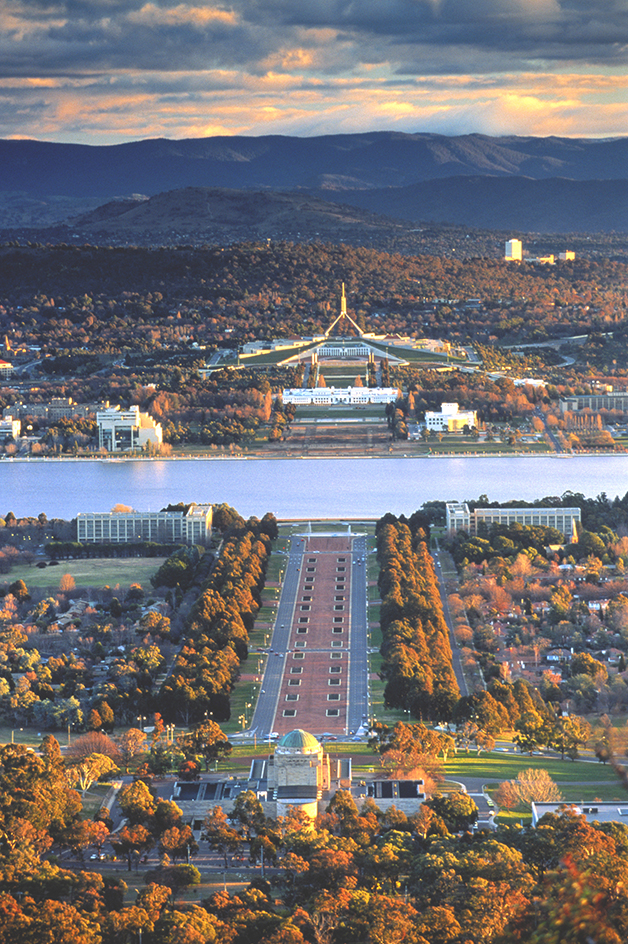
A period of prosperity after World War I (1914-1918) was followed by the severe, worldwide Great Depression of the 1930’s. The state government gave relief work or the dole (unemployment benefits) to many people who were dismissed from their work. J. T. Lang, who was premier of New South Wales from 1925 to 1927 and from 1930 to 1932, put forward some financial policies that alarmed many people. In 1932, Sir Philip Game, the governor, dismissed Lang from the premiership.
The Depression gradually lifted. Then, in 1939, World War II broke out. In 1942, Japanese midget submarines attacked Sydney Harbour. New South Wales developed its industries during the war.
Postwar boom.
After the end of World War II in 1945, New South Wales’s economy grew dramatically. The boom was partly fueled by a steady flow of postwar migrants from Europe. This mass immigration contributed to an increase in construction in the state.
In 1949, construction began on the Snowy Mountains Scheme, a major hydroelectric and irrigation project centered in southeastern New South Wales. It is one of Australia’s greatest engineering projects. Work on the project lasted about 25 years. European immigrants provided a large portion of the work force. The project consists of an extensive system of dams, aqueducts, and tunnels, as well as seven power stations.
The prosperity of Sydney increased rapidly in the second half of the 1900’s. However, Sydney’s growing prosperity also created an economic divide between the state’s urban and rural regions.
In 1973, the world-famous Sydney Opera House opened. It has become a major attraction for millions of Australian visitors and international tourists, hosting a variety of plays, operas, and recitals. 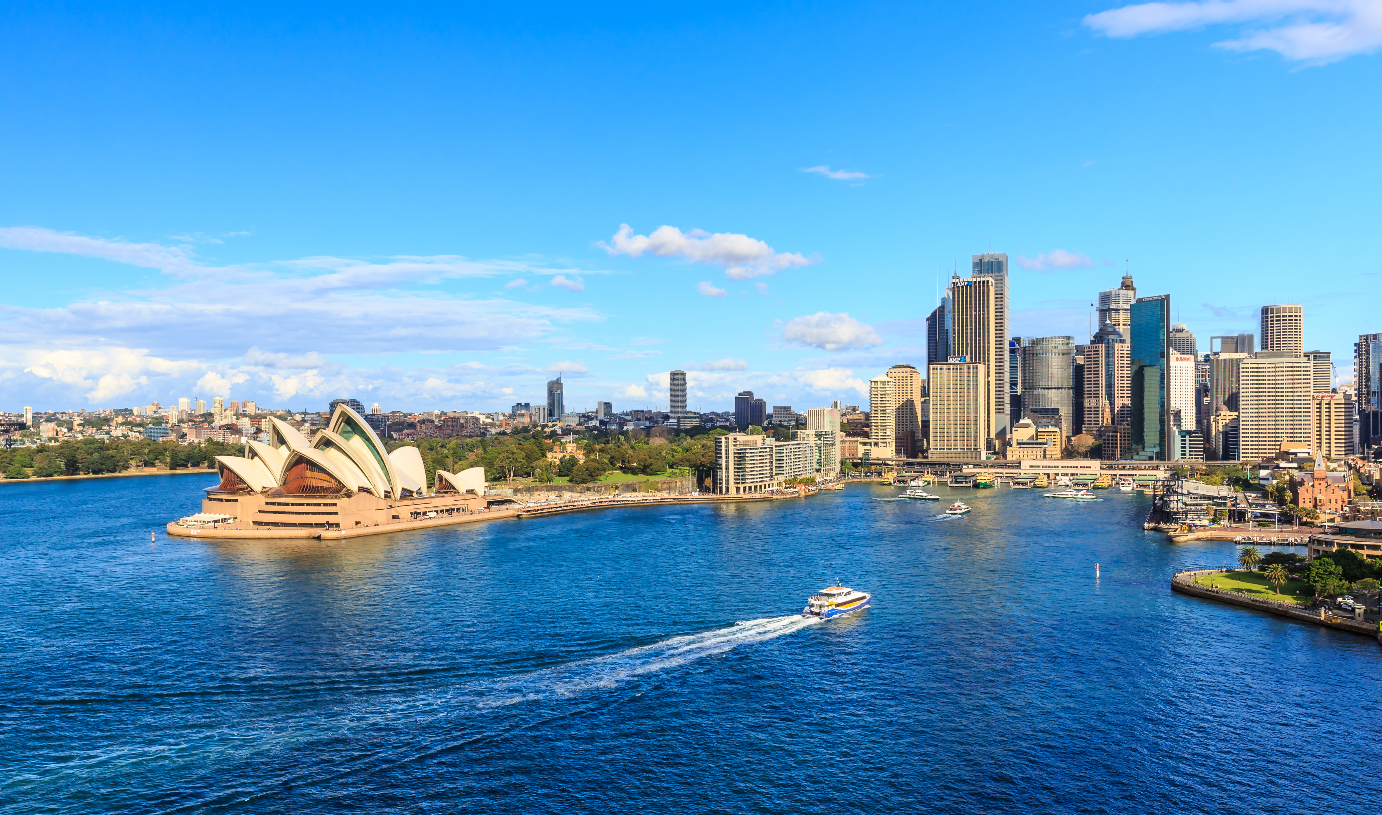
By the 1990’s, Sydney had become the financial center of Australia, as well as the country’s gateway for foreign visitors and immigrants. Building projects improved transportation and added new skyscrapers to the city’s skyline. Since the 1970’s, the Asian population of the state has grown considerably, particularly in suburban Sydney.
Recent developments.
In 2000, Sydney hosted the summer Olympic Games. During the early 2000’s, economic growth in the Sydney metropolitan area continued. The role of service industries in the area’s economy increased. These industries include financial, information media, technical, and telecommunications services. They also include education and health services. This growth has attracted workers from other parts of Australia and from other nations, adding to the region’s multicultural character.
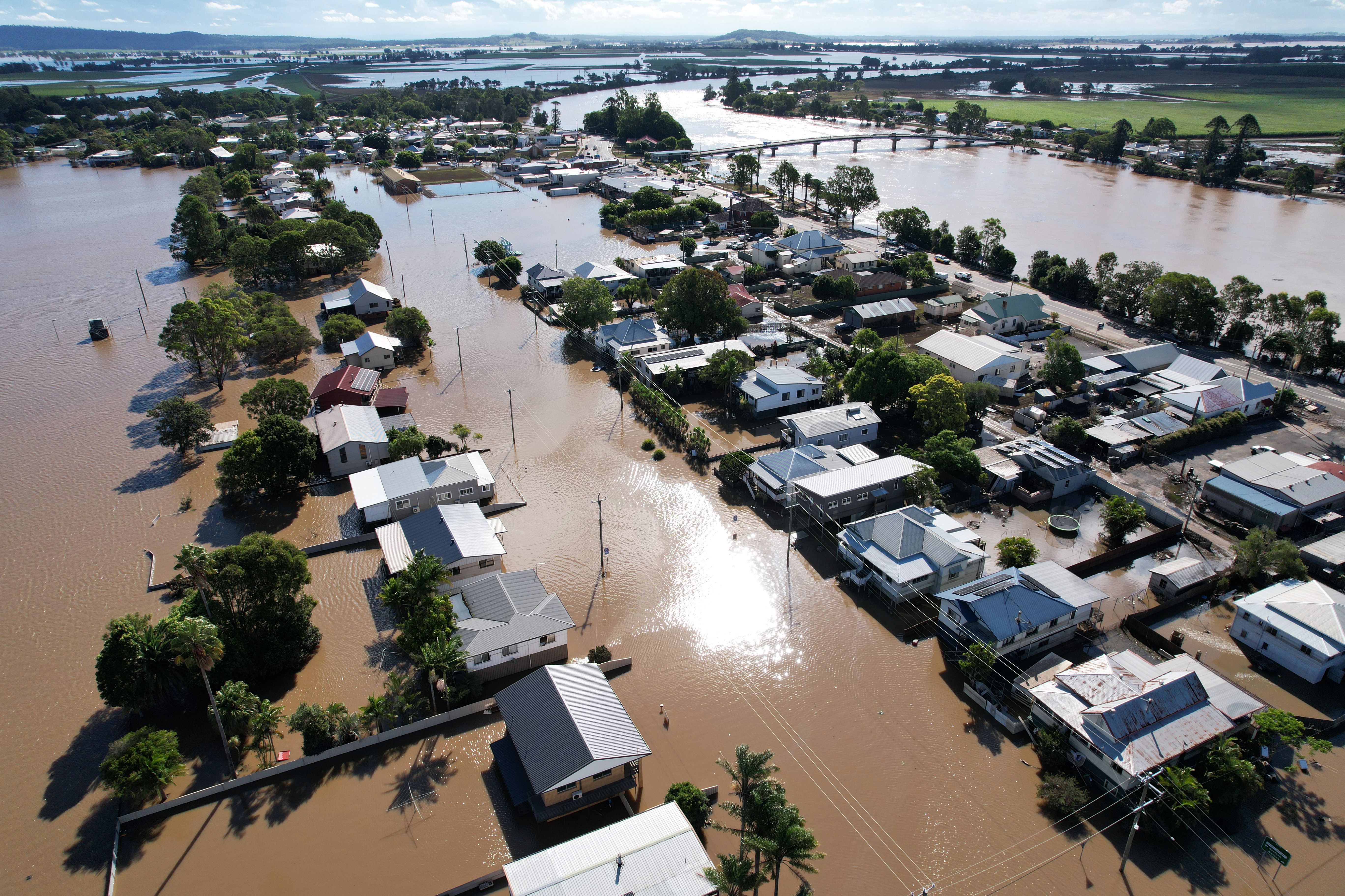
In the early 2000’s, much of the state was affected by a prolonged drought, causing many rural families and businesses to suffer severe economic hardship. Very dry conditions in 2013 preceded bushfires that burned across New South Wales in late October and early November. Some of the worst fires were in the Blue Mountains west of Sydney.
In late 2019, intense drought conditions, combined with high temperatures, led to a widespread outbreak of bushfires across eastern Australia. New South Wales was hit particularly hard. By the time heavy rains in February helped to extinguish the fires, about 13 million acres (5.5 million hectares) of land had burned in New South Wales. Twenty-five people in the state were killed, and more than 2,400 homes were destroyed.
In 2019, the Metro North West Line in Sydney’s northwestern suburbs became the first section of the new Sydney Metro rapid transit commuter railway to open. Work to extend the line beneath Sydney Harbour and the city’s Central Business District is scheduled for completion in 2024. Construction on a line to the Western Sydney International Airport began in 2020.
The COVID-19 pandemic (worldwide epidemic) spread to Australia in 2020. The nation’s most serious outbreaks occurred in the urban areas of the southeast. Efforts to contain the spread of the disease in New South Wales included lockdown periods with restrictions on travel and social activity.
