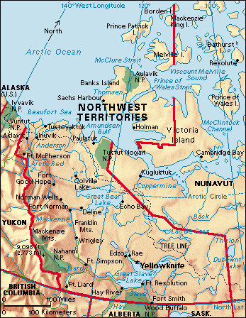
Northwest Territories is a vast region in northern Canada. It stretches from the northern boundaries of the provinces of British Columbia, Alberta, and Saskatchewan north to islands in the Arctic Ocean. The Northwest Territories is a cold, rugged region with relatively few people. Politically, it is one of three territories in northern Canada. It lies between the two other territories: Yukon, to the west, and Nunavut, to the east. The capital of the Northwest Territories is Yellowknife.
People
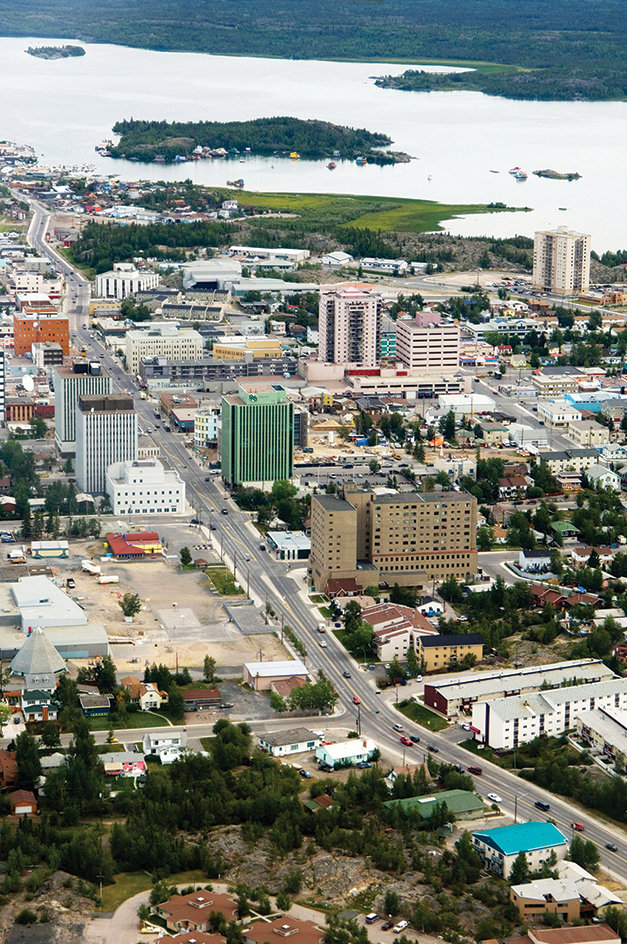
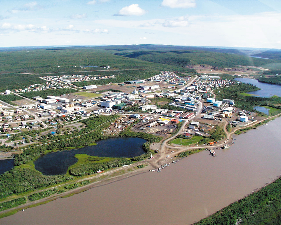
The Northwest Territories is sparsely populated. It has only about 35 scattered and mostly tiny communities. Yellowknife is the only city. It is the territorial capital and a mining center. About half of the people of the Northwest Territories live there. Fort Smith, Hay River, Inuvik, and Norman Wells are incorporated towns.
Three main Indigenous (native) groups—First Nations, Inuit, and Métis—make up about half of the population of the Northwest Territories. Métis are people with both First Nations and European ancestry. Most of the non-Indigenous people are of European ancestry. The territory has multiple official languages, including English, French, and a number of Indigenous languages.
The First Nations people in the area call themselves collectively Dene, which means people. Individual First Nations groups include the Bear Lake people (also called the Sahtu Gotine), the Chipewyan (Denesuline), the Tlicho (Dogrib), the Gwich’in (Kutchin), the Hare (Kasho Gotine), and the Slavey (Dene Tha). The Inuit of the region are called the Inuvialuit.
Land
The central region of the Northwest Territories is the Mackenzie Valley. Within this region is the Mackenzie River, Canada’s longest river and one of the longest in North America. The Mackenzie Mountains extend along the Northwest Territories’ western border. Most of the far eastern and northern parts of the Territories consist of treeless, rocky terrain.
The Mackenzie Mountains
stretch from the Beaufort Sea, in the north, to British Columbia, in the south. The highest elevation in the Northwest Territories is a peak that rises 9,098 feet (2,773 meters) in the southern part of the range. Few people live in the Mackenzie Mountains. The region is difficult to travel through and has few marketable resources.
The Mackenzie Valley
lies east of the Mackenzie Mountains and largely defines the Northwest Territories. The region is a northward extension of the Great Central Plain of North America. It is dominated by the Mackenzie River, which flows 1,100 miles (1,770 kilometers) from Great Slave Lake in the south to the Beaufort Sea in the north. A number of communities with roots in the 1800’s fur trade lie along the river.
The Franklin Mountains stand about 5,000 feet (1,500 meters) tall to the east of the Mackenzie River. Two of the largest lakes in Canada, Great Bear Lake and Great Slave Lake, are east of the Franklin Mountains. Yellowknife lies on the shores of Yellowknife Bay, a projection at the northern end of Great Slave Lake.
Barren grounds.
The rest of the Northwest Territories typically is described as part of the barren grounds, a vast expanse of rolling, rocky terrain that is largely treeless and extends eastward far into Nunavut. Lakes dot the area, and many streams cut through it.
The Northwest Territories also includes a number of islands in the Arctic Ocean. Several of these are divided between the Northwest Territories and Nunavut. Like the Arctic portion of the mainland Territories, these islands support a small population and little vegetation. A number of small Inuit communities developed on the islands after World War II (1939-1945).
National parklands
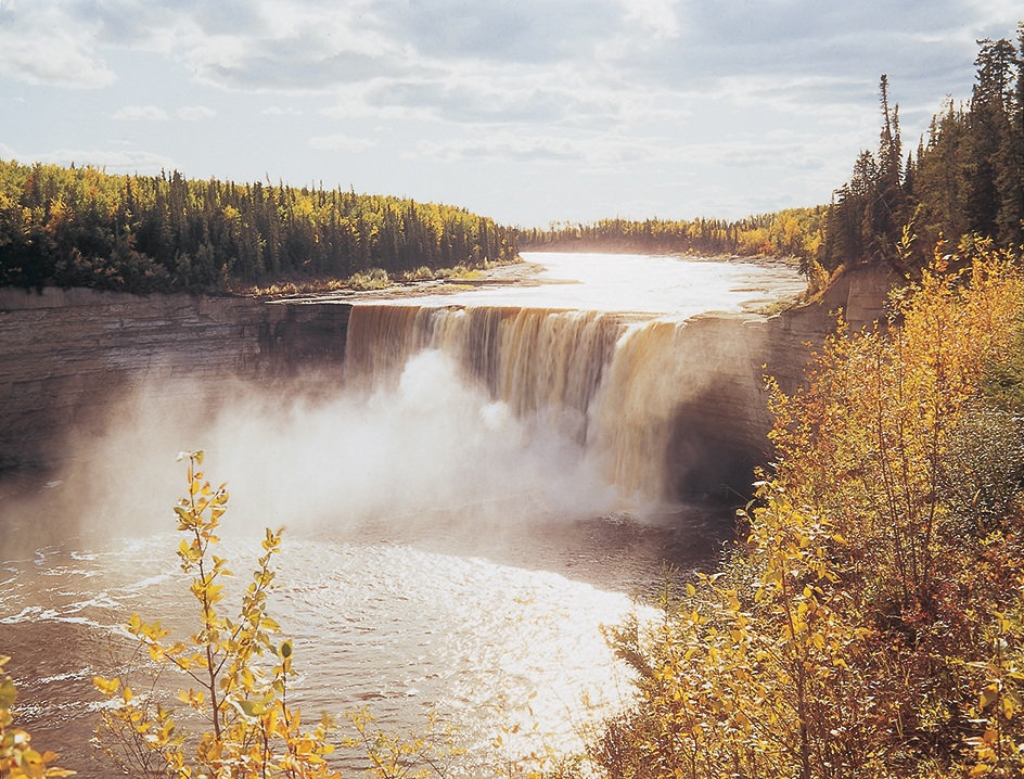
are spread throughout the Northwest Territories. In the southwest corner is Nahanni National Park Reserve, noted for its attractive rivers and majestic waterfalls. Nááts’ihch’oh National Park Reserve, which is adjacent to Nahanni, is home to caribou, grizzly bears, and other animals. Wood Buffalo National Park straddles the border between the Northwest Territories and Alberta. It is home to Canada’s largest remaining herd of buffalo and serves as the spring nesting ground of the endangered whooping crane. Tuktut Nogait National Park lies on the northern coast of the Northwest Territories’ mainland, and Aulavik National Park occupies part of Banks Island in the Arctic Ocean. 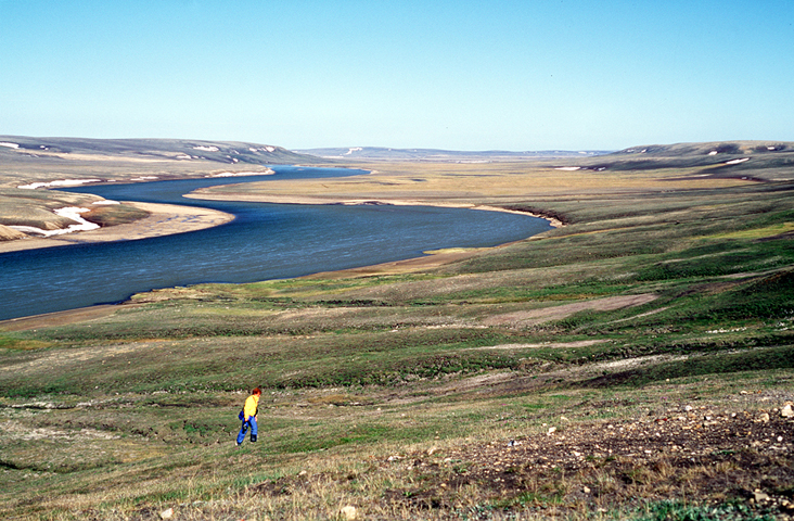
Climate
The Northwest Territories is one of the coldest areas in North America. It has long, bitterly cold winters and short, cool summers. Summer in the Mackenzie Valley is warmer than in the area north of the tree line, the northern limit of forest growth. Inuvik, in the northern Mackenzie Valley, has average temperatures of about 57 °F (14 °C) in July and about –17 °F (–27 °C) in January. To the south, along the border with Alberta, average temperatures are about 63 °F (17 °C) in July and about –8 °F (–22 °C) in January.
During the longest days of summer, the Territories receives nearly 19 hours of sunlight near its southern border and 24 hours of sunlight in the far north. In midwinter, the far south gets about 9 hours of daylight, while areas north of the Arctic Circle have one or more days when the sun does not rise above the horizon.
The average annual precipitation in the Northwest Territories is only 11 inches (28 centimeters). Most of it falls as snow. The mainland gets about 63 inches (160 centimeters) of snow each year, and less than 40 inches (100 centimeters) falls on most of the islands. Much of the Territories has nearly desertlike conditions.
Economy
The landscape and climate of the Northwest Territories limit its economic development. Mining dominates the economy. Government services also play an important role and employ much of the population. Many tourists come to the region for its natural beauty and outdoor activities.
Mining.
Diamonds rank as the leading mined product of the Northwest Territories. Canada’s first diamond mine opened in 1998 near Lac de Gras, about 185 miles (300 kilometers) north of Yellowknife. Additional mines followed in the early 2000’s.
The petroleum industry is important to the Northwest Territories. Oil drilling began at Norman Wells after World War I (1914-1918). Oil was discovered in the Beaufort Sea in the 1970’s. The Northwest Territories also has substantial quantities of natural gas. However, it lacks the pipeline facilities needed to carry the gas to market. Debates over the construction of a gas pipeline have continued since the 1970’s.
Government
at several levels is the largest employer in the Northwest Territories. About one-fourth of all workers hold jobs with the federal, territorial, or municipal (town or city) governments.
Tourism
has become increasingly important to the economy. People from Europe, Japan, the United States, and other parts of the world visit the Northwest Territories to enjoy its rugged beauty and participate in such activities as fishing, hunting, photography, and skiing. In winter, tourists are attracted by the magnificent natural display of light called the aurora borealis (northern lights).
Fishing and forestry
employ relatively few people and produce few exports. Commercial fishing in the Northwest Territories centers on Great Slave Lake, which provides whitefish and lake trout. Forestry is limited by the area’s distance from outside markets and by the slow growth rate and small size of many of the trees. However, loggers do harvest birch, pine, poplar, and spruce, especially in the south near Hay River.
Transportation.
The large size, diverse terrain, extreme climate, and small population of the Northwest Territories make transportation difficult. Moving passengers and goods is costly and slow, and it presents technological challenges.
The Mackenzie Northern Railway operates between Alberta and the town of Hay River, on Great Slave Lake. The Northwest Territories has few permanent roads. The main one, the Mackenzie Highway, runs alongside the railway. Temporary ice roads are used to transport supplies to diamond mines and isolated communities. The main route for carrying goods is the Mackenzie River. However, the river is navigable only three or four months each year. A tug and barge system operates from Hay River and serves communities along the Mackenzie River, to the Beaufort Sea.
Air service is the chief method of passenger travel in the Northwest Territories. It also plays an important role in transporting fresh foods and other perishable goods. Most communities have regular air service. Planes that use floats, skis, and landing gear with wheels serve isolated mining and prospecting sites.
Communications.
Newspapers are published in Yellowknife and in most towns in the Northwest Territories. A system of terrestrial (on land), microwave, and satellite technologies provides radio, telephone, television, and Internet access to all communities. The Canadian Broadcasting Corporation/Radio-Canada (CBC/Radio-Canada) has radio stations in Yellowknife and Inuvik.
Education
Two district educational authorities—public and Roman Catholic—operate schools in Yellowknife. Regional education boards coordinate schools’ activities in other parts of the Territories. First Nations authorities control many local schools, and schools throughout the education system incorporate Indigenous curriculums.
Government
As a territory of Canada, the Northwest Territories does not have all the same political rights and freedoms as the provinces, and it relies heavily on the federal government for financial support. The people elect one member to the Canadian House of Commons. The Northwest Territories has one appointed representative in Canada’s Senate.
Canada’s federal government appoints a commissioner to serve as honorary head of government for the Northwest Territories. A premier actually leads the government. The Legislative Assembly of the Northwest Territories elects the premier and the Cabinet, also called the Executive Council, from among its own members.
The members of the Legislative Assembly are elected to four-year terms as independents rather than as members of political parties. The Assembly governs by consensus (general agreement). This method of government is more in keeping with Indigenous traditions.
The court system includes the Court of Appeal, the Supreme Court, and the Territorial Court. The Court of Appeal hears civil and criminal appeals from the Supreme Court, and criminal appeals from the Territorial Court. The Supreme Court hears civil and criminal cases. The federal government appoints the judges of the Court of Appeal and the Supreme Court.
The Territorial Court handles the majority of criminal cases that enter the court system. It also may hear some civil cases. Its justices, appointed by the territorial government, travel throughout the Territories to hear cases. Justices of the peace appointed by the territorial government also may conduct certain judicial proceedings.
The Northwest Territories has several settlement areas resulting from land-claim and self-government agreements with Indigenous peoples, including the Dene, Inuit, and Métis. The agreements generally recognize Indigenous control of a small percentage of land in the settlement areas. They also give the Indigenous people a one-time cash contribution; royalties (payments) from the development of natural resources; and administrative and political input in the management of the areas. The agreements require the establishment of resource boards with both Indigenous and non-Indigenous representatives. Resource boards manage land, water, and wildlife in the settlement areas.
A growing number of Indigenous groups have some form of autonomy (self-government). These communities exercise control over local education, health care, economic development, and cultural affairs.
History
Early inhabitants.
People have lived in what is now the Northwest Territories for thousands of years. Before Europeans arrived there, groups of Inuit and First Nations people moved across the land to find natural resources and favorable weather. These people developed sophisticated cultural, economic, social, and spiritual systems.
European exploration.
The first European to reach the area was Samuel Hearne, an employee of the Hudson’s Bay Company, a British trading firm. King Charles II of England had granted the company trading rights in a region that included what is now the Northwest Territories. Hearne set out overland from Churchill, in what is now Manitoba, in 1770. He reached the mouth of the Coppermine River the next year. Hearne explored the Great Slave Lake region on his return journey.
In 1789, the Scottish-born Canadian explorer Alexander Mackenzie followed what is now known as the Mackenzie River in search of an overland route to the Pacific Ocean. His journey took him instead to the Arctic Ocean. As a result of Mackenzie’s exploration, the fur trade expanded into the Northwest Territories region. The arrival of traders in the area spread European diseases to the Indigenous population, more than half of which died by the early 1800’s.
Political development.
In the mid-1800’s, the area that is now the Northwest Territories was under the authority of the Hudson’s Bay Company. But the company and the British government did little to administer the area. In 1870, the recently created Dominion of Canada agreed to take over the company’s landholdings and established the North-West Territories. The North-West Territories originally covered an area extending from the Rocky Mountains in the west to the Labrador Peninsula in the east, and from the United States border in the south to the northern coast of mainland North America. Because of a Métis uprising in the Red River Valley, Canada also made part of the company’s lands into the province of Manitoba in 1870. In 1880, Canada took over the Arctic islands that now form part of the Territories.
In 1898, the federal government created Yukon by carving out part of the North-West Territories. A rapid increase in settlement on the Canadian prairies, along with demands for regional representation, resulted in the establishment of Alberta and Saskatchewan in 1905. Like Yukon, these new provinces had been part of the Territories. The North-West Territories was renamed the Northwest Territories in 1906. Manitoba, Ontario, and Quebec were expanded northward in 1912, further diminishing the Territories’ area.
The early and middle 1900’s.
Development of the region through the early 1900’s was linked strongly to the discovery of marketable resources there. These resources included baleen whales, hunted from the late 1880’s to the early 1900’s, and, later, mined products such as crude oil, gold, and radium ore.
The Canadian government’s presence in the Territories consisted of a small number of schools, post offices, and weather stations, and occasional geological surveys and medical services. The government relied upon small detachments of the North-West Mounted Police to provide oversight and services to the widely scattered population. Few non-Indigenous people ventured into the northeastern portion of the territory following the decline of the whaling industry in the early 1900’s.
During World War II (1939-1945), the United States launched the Northwest Defense Projects as part of its strategy to defend North America from Japanese attack. In the Northwest Territories, these projects included the construction of airfields and the development of barge facilities along the Mackenzie River. The Territories’ radium deposits also became important during World War II because they contained uranium, which was used to develop the first atomic bomb. In the middle of the war, the Canadian government assumed responsibility for mining the region’s radium and uranium ore.
In the 1950’s, the Canadian government moved Indigenous people off their land and onto government-built communities. The government enacted housing, employment, education, health care, and cultural programs to improve Indigenous people’s social and economic conditions. However, threats to the Indigenous hunting-and-gathering culture, as well as the absence of meaningful wage employment in the new communities, made the transition from a mobile to a settled lifestyle painful and disruptive. It began an era of intense cultural dislocation and personal crisis for Indigenous peoples across the region.
In the 1950’s and 1960’s, private industry and the Canadian government began to develop the Northwest Territories’ natural resources. Work expanded at the gold fields at Yellowknife and at the Norman Wells oil field. A lead zinc mine opened at Pine Point. Petroleum exploration in the Beaufort Sea showed promise. The Canadian government supported resource development by building roads and funding the construction of a railway to Pine Point. But many mines closed after a short time. During the 1970’s, Indigenous-led protests stalled plans for a natural gas pipeline from the Beaufort Sea.
Before 1967, the Northwest Territories’ government had been based in Ottawa, thousands of miles away. A regional administrative center operated at Fort Smith. The decision to make Yellowknife the capital in 1967 brought about rapid growth of the city. The creation of the new capital was part of a process of devolving (shifting) government responsibilities from the federal government to the Territories. The Territories attained responsible government, a system in which the elected officials, rather than the appointed commissioner, were directly responsible for managing territorial affairs.
The late 1900’s.
The Inuit of the eastern Territories felt that the government in Yellowknife was out of touch with Indigenous needs, and they wanted more control over their own affairs. A 1992 plebiscite (direct vote by the people) resulted in formal approval to create a huge new political unit controlled largely by the Inuit from the eastern Territories. The Canadian Parliament authorized the division of the Northwest Territories in 1993, and the territory of Nunavut came into existence in 1999. With the creation of Nunavut, the area of the Northwest Territories was reduced by more than half—from 1,322,910 square miles (3,426,320 square kilometers) to 501,570 square miles (1,299,070 square kilometers).
The economy of the Northwest Territories improved dramatically in the 1990’s with the beginning of diamond mining in the region. The mines marketed Canadian diamonds as an alternative to blood diamonds—that is, diamonds mined by rebels in African countries to fund violent conflicts.
Recent developments.
The Northwest Territories is a region in transition. Its economy remains vulnerable to changes in the market values of such resources as oil, natural gas, and diamonds. The resolution of Indigenous land claims has empowered most First Nations and Inuit communities in the Territories. Indigenous people play an active role in regional government, and autonomous communities have gained greater control over education, health care, and economic development. Though social problems such as alcohol abuse persist, the First Nations, Inuit, and Métis communities have experienced significant improvements.
