Peace River, in western Canada, is the largest tributary of the Mackenzie River. It is 1,195 miles (1,923 kilometers) long, including the length of its main branch, the Finlay River. It drains the Peace River region, a fertile farming area in northwestern Alberta and eastern British Columbia.
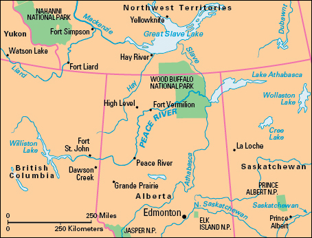
The Finlay River flows north, then south, to Williston Lake in central British Columbia. The Peace River flows east from the lake. It cuts through the Rocky Mountains and flows in a general easterly direction for about 300 miles (480 kilometers). At the town of Peace River in Alberta, soon after the Smoky River joins it, the Peace turns and flows north through steep sandstone cliffs. The river bed then gradually widens and becomes more shallow. The river flows northeast across Wood Buffalo National Park. On the park’s eastern border, the Peace River enters the Slave River 945 miles (1,521 kilometers) from the Peace’s source at Williston Lake.
During the early fur trade, the Peace River was part of a major freight route. A railway built from Edmonton, Alberta, during World War I (1914-1918) helped open up the Peace River area. Grande Prairie, Alberta, is now the center of this area, which is the northernmost commercial crop-producing region in North America. The main crops include barley, canola, and wheat.
Williston Lake was formed in 1968 by the construction of the W.A.C. Bennett Dam across the Peace River. It is the largest body of fresh water in British Columbia. It covers 680 square miles (1,761 square kilometers).
Vast pools of oil and natural gas lie beneath the Peace River region. There are also deposits of bituminous sands, also called tar sands, which contain a substance from which oil can be obtained. Pipelines transport these resources to Edmonton, and on to other parts of Canada and the United States. Natural gas refined at Taylor in eastern British Columbia travels by pipeline to southern British Columbia and the United States.
