Ring of Fire is a zone along the edge of the Pacific Ocean that has many volcanoes and earthquakes. This horseshoe-shaped belt stretches about 25,000 miles (40,000 kilometers) from New Zealand northwest to the Philippines, northeast to Japan, east to Alaska, and south to Oregon, California, Mexico, and the Andes Mountains of South America.
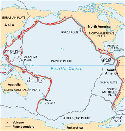
Scientists believe that the motion of tectonic plates (pieces that make up the strong outer shell of the earth) cause the Ring of Fire’s earthquakes and volcanic eruptions. Tectonic plates move slowly on an underlying layer of weak rock that is so hot it flows, even though it remains solid. The edge of one plate sinks beneath the edge of a neighboring plate in a process called subduction. The movements of subduction generate many earthquakes and usually a line of volcanoes along the upper plate’s boundary. A volcano erupts where melted rock, hot gases, and fragments of solid rock burst through to the earth’s surface.
The Ring of Fire is the site of thousands of earthquakes each year. The largest earthquake ever recorded occurred there, along the coast of Chile in 1960.
Although the Ring of Fire covers only about 1 percent of the earth’s surface, it has more than half the world’s active volcanoes. There are about 350 historically active volcanoes in the zone. Eruptions occurred in the late 1900’s at Mount St. Helens in the United States and Mount Pinatubo in the Philippines. The hot gases of volcanic activity carry dissolved metals toward the surface, where they settle out. Geologists have found copper, gold, molybdenum, silver, tin, and tungsten where ancient volcanic activity occurred within the Ring of Fire.
