Saint Lawrence River is one of the most important rivers of North America. The St. Lawrence flows about 800 miles (1,300 kilometers) from its headwaters at Lake Ontario to its mouth in the Gulf of St. Lawrence. It drains an area of about 498,500 square miles (1,291,100 square kilometers), including most of southeastern Canada.
The St. Lawrence River links the Atlantic Ocean with the Great Lakes by means of the St. Lawrence Seaway (see Saint Lawrence Seaway ). The river and the seaway help make the ports on the Great Lakes some of the busiest in the world. The St. Lawrence River served as the first highway of the explorers, fur traders, and colonists who came to Canada and the United States hundreds of years ago. It is often called the Mother of Canada.
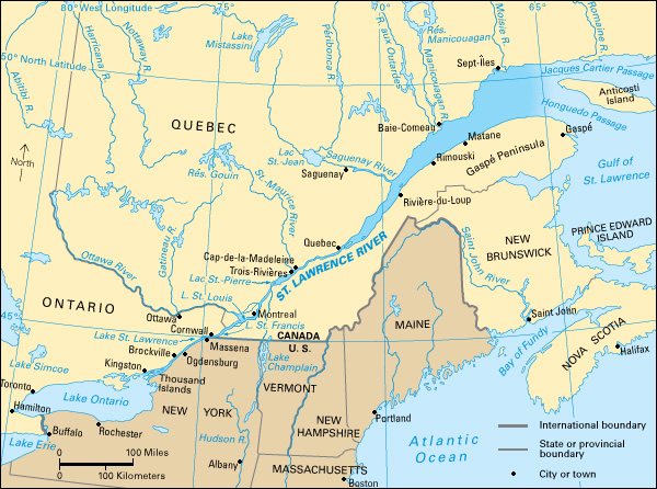
The course of the St. Lawrence.
The St. Lawrence River and the waterways that flow into it make up the St. Lawrence River system. The source of this system is the St. Louis River, which enters Lake Superior at Duluth, Minn. The system includes Lakes Superior, Michigan, Huron, Erie, and Ontario and the rivers that connect them. It extends about 2,280 miles (3,669 kilometers) from its source to the Gulf of St. Lawrence. The St. Lawrence River itself begins at the northeast end of Lake Ontario and flows northeast. Like most rivers, the St. Lawrence River has an upper, middle, and lower part.
The upper St. Lawrence flows from Lake Ontario to Montreal, Quebec. The first two-thirds of the upper part of the river form the boundary between Canada and the United States. All the rest of the St. Lawrence lies entirely within Canada and flows chiefly through the province of Quebec. The Thousand Islands, a group of more than 1,700 islands, lie within a 40-mile (64-kilometer) section of the river as it leaves Lake Ontario. The upper river’s chief tributary, the Ottawa River, flows into the St. Lawrence just west of Montreal.
Most of the upper St. Lawrence has an average width of 11/4 miles (2 kilometers). But the river broadens in some places to form such “lakes” as Lake St. Francis and Lake St. Louis. The upper St. Lawrence has about 30 miles (48 kilometers) of rapids. It falls from 243 feet (74 meters) above sea level at Lake Ontario to 20 feet (6 meters) above sea level at Montreal.
The middle St. Lawrence extends from Montreal to Quebec City, Quebec, and is about as wide as the upper river. It includes one “lake,” Lac St.-Pierre.
The lower St. Lawrence is about 10 miles (16 kilometers) wide near Quebec City. It broadens to 90 miles (145 kilometers) at its mouth at the western tip of Anticosti Island in the Gulf of St. Lawrence. Every second, the river empties about 400,000 cubic feet (11,000 cubic meters) of water into the gulf. The gulf is a deep arm of the Atlantic Ocean, and the tides of the ocean affect the river as far west as Trois-Rivières, Quebec. The tides may raise the level of the river as much as 19 feet (5.8 meters). East of Trois-Rivières, the ocean changes the water of the river from fresh to salty.
Commerce.
The St. Lawrence carries more freight than any other river of Canada—over 60 million tons (54 million metric tons) annually. About 40 percent of this cargo moves between North America and countries overseas.
The freight carried on the St. Lawrence consists chiefly of bulk cargo. Such cargo includes grain, iron ore, and other goods that are stored loose in the holds of ships called dry bulk carriers. These ships carry iron ore from western Labrador in Quebec to the steel mills of Chicago, Cleveland, and other ports on the Great Lakes. The ships return with grain from lake ports. Iron ore accounts for about half the freight traffic up the river, and wheat and other grains make up about three-fourths of the downriver freight.
The lower St. Lawrence is more than 100 feet (30 meters) deep, but the river becomes much shallower upstream. Until 1959, parts of the upper St. Lawrence were too shallow for large ships to pass through. That year, the United States and Canada completed the St. Lawrence Seaway, which provided a navigation channel 27 feet (8 meters) deep. The seaway enabled most oceangoing vessels to sail between the Atlantic Ocean and such Great Lakes ports as Toronto; Thunder Bay, Ontario ; Detroit; and Milwaukee. The project also included construction of a hydroelectric power dam on the river near Cornwall, Ontario.
Animal and plant life.
The St. Lawrence and its valley are the home of many kinds of animals and plants. Fishes of the river include bass, eels, perch, pike, smelts, and trout. Forests of birch, elm, hemlock, maple, oak, and spruce trees grow along the river’s shores. The woods provide shelter for bears, deer, foxes, moose, muskrats, opossums, rabbits, raccoons, skunks, and squirrels. Such waterfowl as ducks, geese, gulls, and loons build their nests near the river.
Pollution from factories, sewage, and ship wastes is the greatest threat to the river’s wildlife. Canada and the United States have taken steps to control this pollution.
History.
The channel of the St. Lawrence was formed by the same glacier that carved out the Great Lakes. The glacier melted from about 11,500 to 15,000 years ago, toward the end of the most recent ice age. The resulting water created the lakes and the river.
Algonquian and Iroquoian people lived along the St. Lawrence before Europeans arrived. The French explorer Jacques Cartier led an expedition up the river in 1535. On August 10, the feast day of Saint Lawrence, Cartier entered a bay that he named the Gulf of St. Lawrence. From there he sailed to what is now Montreal, where he was stopped by rapids. Cartier called the river the River of Canada, but it became known as the St. Lawrence about 100 years later.
During the 1600’s, the French established settlements at Quebec City, Trois-Rivieres, Montreal, and other points along the river. Many of these settlements became fur-trading centers and busy ports. The St. Lawrence also became part of a route to settlements in what is now the United States.
The United Kingdom won control of almost all French lands in Canada in 1763. The St. Lawrence then became a main transportation route for the huge cargoes of furs, timber, wheat, and other Canadian exports shipped to the United Kingdom.
Various attempts were made to improve navigation on the St. Lawrence River. In 1680, construction of a canal was begun to enable traders and trappers to by-pass the rapids near Montreal. Other canals were added through the years, and work on the St. Lawrence Seaway began in 1954. Each year, the upper St. Lawrence freezes for the winter. Canada and the United States are seeking ways to keep the river open the year around without harming the environment.
