Tornado is the most violent of all storms. A powerful tornado can lift cars, cattle, and even mobile homes into the air. It can destroy almost everything in its path.
Loading the player...Tornado
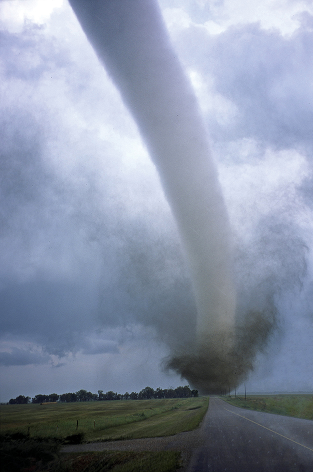
A tornado is a rapidly rotating column of air known as a vortex that has reached the ground. It is often associated with a funnel cloud, a funnel-shaped cloud that may appear near the ground in a thunderstorm. Tornado winds swirl at speeds that may exceed 300 miles (480 kilometers) per hour on rare occasions. Tornadoes are also sometimes called twisters.
Scientists use the word cyclone to refer to all spiral-shaped windstorms. Cyclones circulate in a counterclockwise direction in the Northern Hemisphere and in a clockwise direction in the Southern Hemisphere. Such storms come in many sizes. Among the largest and most intense are hurricanes and typhoons, which may reach 250 miles (400 kilometers) across. Most tornadoes are small, intense cyclones. On rare occasions, tornado winds whirl in the direction opposite that of a cyclone—for example, clockwise in the Northern Hemisphere.
Loading the player...Tornado winds
A destructive tornado may reach 1 mile (1.6 kilometers) in diameter. It may travel at 60 miles (100 kilometers) per hour and blow for more than an hour. Fortunately, most tornadoes are smaller and weaker. Most move at less than 35 miles (55 kilometers) per hour and last only a few minutes.
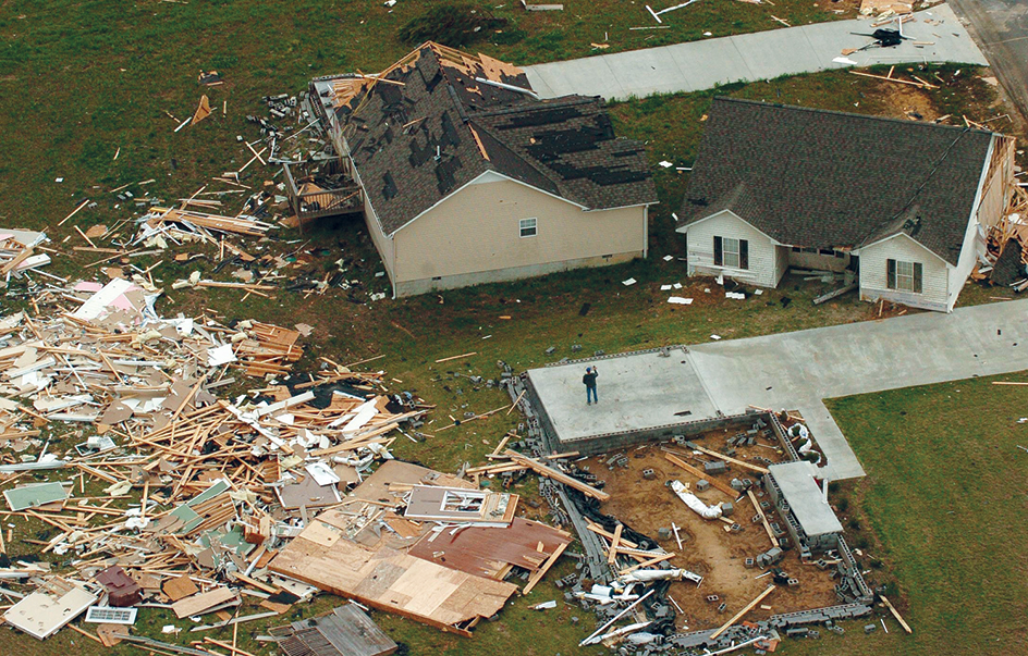
Tornado damage is often localized. A tornado may demolish one house and leave a nearby house untouched. Most tornadoes create a path of devastation less than 1,600 feet (500 meters) wide.
The United States has more tornadoes than any other country. Most of these storms occur in a belt known as Tornado Alley. It stretches across the Midwestern, Plains, and Southern states, especially Texas, Oklahoma, Kansas, Nebraska, and Iowa. However, tornadoes also strike other parts of the world. Areas where tornadoes occur include much of Europe, Japan, parts of China, South Africa , and parts of Argentina and Brazil. Australia ranks second to the United States in number of twisters. Many tornadoes also strike Bangladesh and eastern India.
How a tornado forms
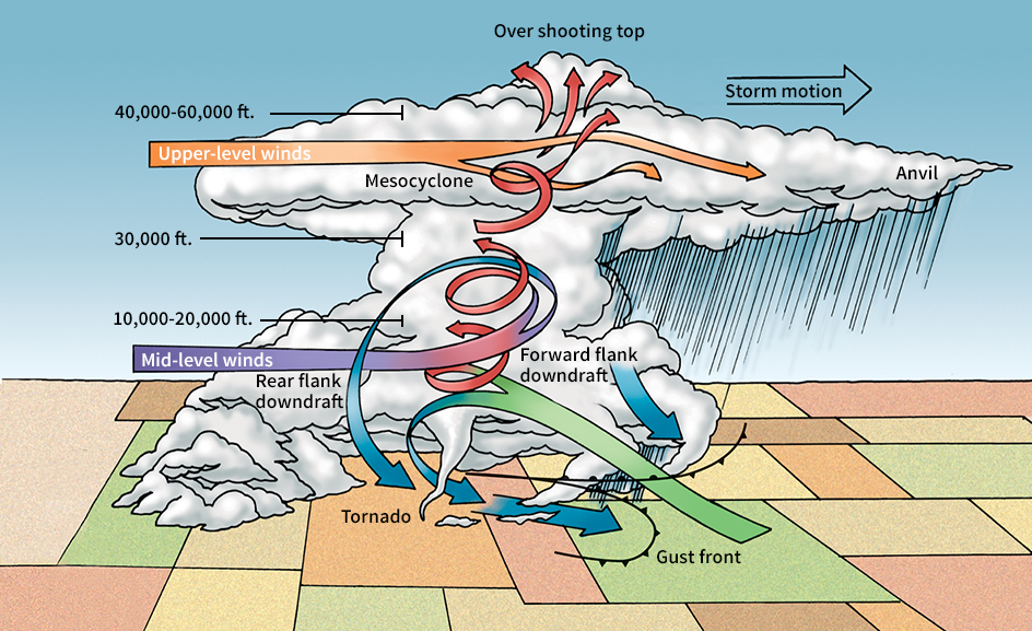
The most damaging tornadoes form in storms called supercells. A supercell is a large, powerful thunderstorm. It contains a rapidly rotating air mass called a mesocyclone. For a supercell to form, and perhaps spawn a tornado, several basic conditions must exist. There must be an adequate supply of moisture to feed the storm. There must be a layer of warm, moist air near the ground and a layer of cool air above. Finally, the winds at higher elevations must differ from those at lower levels in speed, direction, or both. 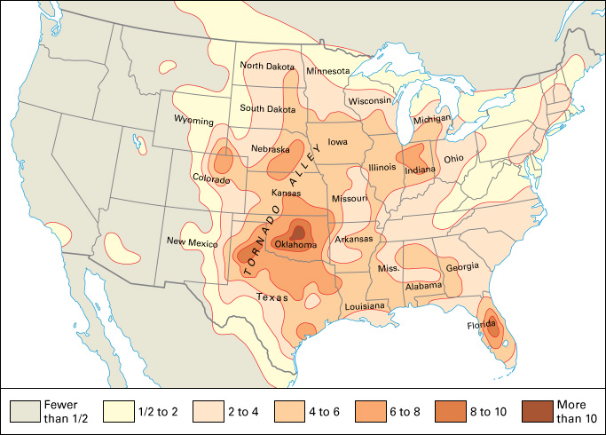
Moisture.
The first requirement for most tornadoes is moisture. In Tornado Alley, air from the Gulf of Mexico provides the moisture to fuel a twister. The warm water of the Gulf evaporates into the air.
Tornadoes and other severe storms often form along a dryline. In North America, the dryline is a boundary separating warm, moist air from the Gulf of Mexico and hot, dry air from the west.
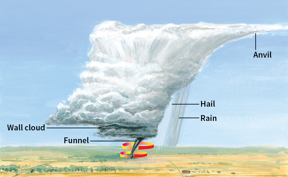
If the humidity is high and rain-cooled air enters the main updraft (upward flow of air), a wall cloud forms. A wall cloud is a low-hanging, dark, cloud. Most funnel clouds develop from a wall cloud. If the humidity is low beneath the wall cloud, a tornado may form only a column of dust with no visible funnel cloud.
Air temperature.
If there is warm, moist air at a lower altitude and cold, dry air at a higher altitude, the warmer air may become buoyant and rise rapidly. The air cools as it rises. The faster the warm air rises, the larger and more violent the storm and the more likely it will spawn a tornado. Storms may develop when warm air rides up over a shallow layer of cooler air. Storms may also form when moist air lifts over mountains, hills, or other high spots.
Often, a front powers an updraft of warm, moist air. A front is the boundary between two air masses of different densities resulting from a difference in temperature, humidity, or both. As the warm, less dense air rises, it begins to cool. The moisture it holds condenses into water droplets, forming a cloud. When the air rises high enough and becomes cold enough, its moisture turns into ice crystals. High in the atmosphere, often far above 35,000 feet (10,700 meters), the cloud stops rising. Upon reaching its maximum height, its top spreads out in the shape of an anvil. Anvil-shaped storm clouds often produce thunder, heavy rain, lightning, and hail. In the right conditions, a deadly tornado may form under the base of the cloud.
Winds.
Another requirement for a supercell is that winds at higher elevations greatly differ from those at lower levels in speed, direction, or both. A difference in wind speed or direction is called wind shear. Wind shear makes the column of rising air begin to rotate. At first, the swirling air forms a broad, horizontal tube. As the storm develops, the tube tilts upright. It becomes the rotating column of air called a mesocyclone.
Most tornadoes occur in supercells. But some appear in a large group of storms called a mesoscale convective system (MCS). Mesoscale means medium-sized. Convective refers to convection, the turbulent upward and downward motions of air among the storms. An MCS is a cluster of thunderstorms that act as a system and often produce severe weather.
The life of a tornado
Tornadoes occur most often during the spring and early summer. Most happen in the late afternoon and early evening. The majority of tornadoes develop from severe thunderstorms. A hurricane, when it makes landfall, can also generate tornadoes.
The first sign of an approaching tornado may be light rain. Heavier rain follows and then rain mixed with hail. The hailstones may grow to the size of golf balls or even oranges. After the hail ends, a tornado may strike. In most tornadoes, a funnel-shaped cloud forms and descends from the wall cloud until it touches the ground. However, there might be a tornado even if the air is too dry for a visible funnel cloud to form. Sometimes, the first sign of a tornado is dust swirling just above the ground.
Some tornadoes contain smaller, short-lived, rotating columns of air called suction spots or suction vortices. The suction spots revolve around the center of the tornado and can inflict great damage to small areas. When these smaller vortices form, the overall vortex or rotating tornado cloud tends to be wide.
Tornadoes form over water as well as over land. Tornadoes over water, called waterspouts, carry large amounts of mist and spray. Waterspouts occur frequently in summer over the Florida Keys. Waterspouts also form elsewhere in the Gulf, along the Atlantic and Pacific coasts, over the Great Lakes, and even over the Great Salt Lake in Utah.
A few small tornadoes begin near the ground and build upward, instead of descending from the clouds. These storms are often called landspouts because they look like waterspouts over land.
Damage by tornadoes
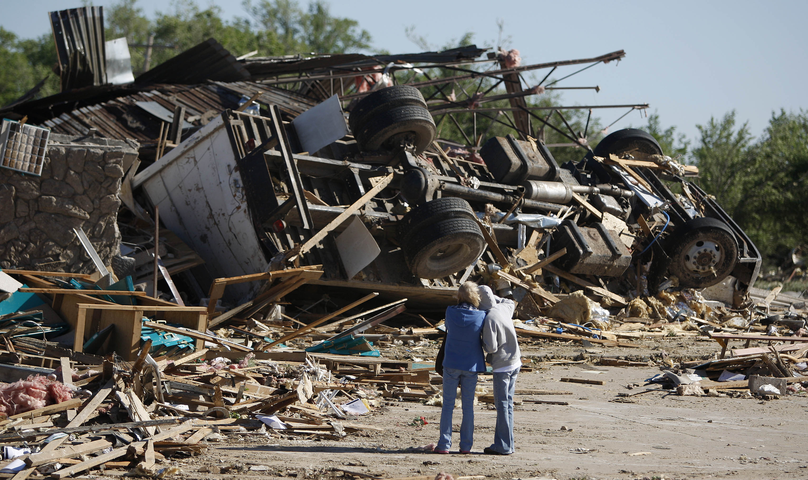
Most tornado damage results from the wind. Each time the wind speed doubles, the force of the wind increases four times. For example, the force of the wind at 220 miles (350 kilometers) per hour is four times as great as the force at 110 miles (175 kilometers) per hour. This tremendous strength may knock over buildings and trees. Other damage occurs when gusts of wind pick up objects and hurl them through the air.
The Fujita scale.
Scientists estimate the wind speed of a tornado by the damage it inflicts. For years, they used a system called the Fujita scale. The Japanese-born weather scientist T. Theodore Fujita developed the scale in 1971. In the early 2000’s, scientists developed a revised system called the Enhanced Fujita scale. On the Enhanced Fujita scale, EF0 is the weakest rating and EF5 is the strongest. An EF5 tornado can remove a house from its foundation.
Air pressure.
Air rising from the ground in the vortex of a tornado creates an area of low air pressure near the ground. For this reason, some people open their windows if a tornado threatens. This precaution is meant to help equalize the indoor pressure with the air outside. The people fear that the air pressure outside the building might drop so suddenly that the structure would explode outward. Safety experts know, however, that air moves in and out of most buildings quickly. The air pressure remains nearly equal inside and out, even during a tornado. Open windows do not reduce the damage. Instead, they may increase the destruction if the wind hurls loose objects through the openings.
Forecasting tornadoes
Meteorologists (scientists who study weather) hope to learn more about tornadoes to better forecast these destructive storms. They can predict with some accuracy 12 to 48 hours in advance if severe weather, and possibly a tornado, threatens an area. Forecasts are made using data from weather balloons, radar, and satellites.
In the United States, the National Weather Service issues a tornado watch when weather conditions are right for the formation of tornadoes. If a tornado watch is issued in your area, you should keep alert for threatening weather. Listen to the radio or television or check the Internet for more information.
If radar detects a mesocyclone or a pattern characteristic of a tornado, the National Weather Service issues a tornado warning. The characteristic radar pattern is called a tornado vortex signature. It indicates a region of strong rotation in a thunderstorm. The Weather Service also issues a tornado warning if someone actually sees a funnel cloud or tornado.
If a tornado warning is issued for your location, take cover immediately. The safest place is a basement or other underground shelter. If no underground shelter is available, an interior bathroom or closet is best.
Studying tornadoes
Tornadoes are difficult to study. They form fast, vanish quickly, and occupy a small area. Another problem is that scientists do not know exactly what causes tornadoes. As a result, they find it difficult to reach the right place at the right time to gather data.
Meteorologists investigate tornadoes using a combination of field studies, computer modeling, and studies with devices called vortex chambers. From this research, scientists hope to learn how, when, and why tornadoes form. This knowledge will enable them to increase warning times. It will also help to reduce the number of false alarms and provide more accurate warnings.
Field studies
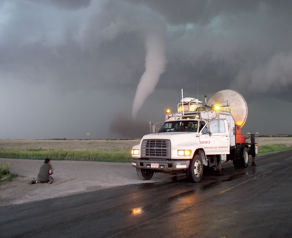
take place outdoors. Scientists go into the field to study tornadoes up close. Many meteorologists form mobile teams of “storm chasers” to study tornadoes. The storm chasers travel in specially equipped automobiles, trucks, vans, and aircraft. They try to get as close as is safe to a tornado to study it.
Radar.
Meteorologists use a special type of radar called Doppler radar to look for mesocyclones. Doppler radar enables storm chasers to map the wind’s speed and direction, rather than merely track areas of precipitation. Doppler radar works because radar waves change frequency depending on whether the objects they bounce off, such as raindrops or dust particles, are advancing or receding. This change in frequency is called the Doppler effect. It can reveal the rotating pattern of a mesocyclone. As a result, Doppler radar can detect the development of a tornado before it descends from its parent thunderstorm and touches down.
With Doppler radar, meteorologists can also study the changes that take place in a thunderstorm before a tornado forms. Pairs of similar radars at different locations can allow meteorologists to estimate both the horizontal and vertical movements of the wind.
Some radar systems can scan a section of the sky rapidly. Rapid-scanning radar enables scientists to record and study even the fastest-forming twisters.
A few radar systems enable scientists to distinguish among airborne debris, drops of drizzle, hailstones, insects, and raindrops. These radars scan by transmitting polarized beams of radiation both vertically and horizontally. Most Doppler radars typically use only horizontally polarized beams. Beginning in 2011, the National Weather Service is updating its network of Doppler radars to include this capability.
Clean air contains few particles large enough for regular radar to detect. To map winds that carry little moisture or dust, meteorologists use a Doppler lidar system. A lidar is a system similar to radar but uses a signal with a much shorter wavelength. Even clean air has extremely small particles called aerosols floating in it. Lidar’s shorter wavelength signal can detect these tiny particles. But lidar cannot penetrate far into clouds, rain, or hail.
Researchers may record a tornado and the flying debris around it on film or video to help analyze wind patterns. They then compare the film with the radar images of the storm. Scientists may also survey the damage done by a tornado and compare it with the radar data.
The VORTEX projects.
Beginning in 1994, scientists carried out two major research projects to study tornadoes. The projects were called the Verification of the Origins of Rotation in Tornadoes Experiment (VORTEX). The first project, VORTEX1, took place in 1994 and 1995. Scientists traveled in both ground-based vehicles and aircraft equipped with customized weather instruments. The project produced insight into tornado formation. It also promoted advancements in Doppler radar.
VORTEX2 followed in 2009 and 2010. More than 100 scientists traveling in dozens of vehicles participated. Unlike many earlier experiments, VORTEX2 did not have a home base. Instead, the storm chasers roamed from place to place. They used weather forecasts and their own instruments to position themselves in areas where tornadoes would likely form.
The VORTEX2 team used a vast array of scientific equipment. Radar, lidar, video, and film recorded any storms. Mobile radars scanned supercells likely to produce tornadoes. Instruments called disdrometers measured the size of raindrops or hail in storms. Weather balloons launched in various locations recorded environmental conditions. VORTEX2 also used remotely controlled aircraft called drones to fly near storms and gather meteorological data.
The VORTEX2 team also released nearly 40 instrument packages, called Sticknets and Tornado Pods, where the team hoped a tornado would pass. The instruments provided information about conditions inside the funnel cloud, such as air pressure and humidity.
Computer modeling.
Meteorologists make extensive use of computer models to study tornadoes. A computer model is a set of mathematical equations processed by computers. Scientists can easily vary the conditions in the models to test their theories. This use of computer modeling is known as simulation. For example, scientists can simulate supercells, storms, and smaller-scale vortexes. Most models are so complex that they require fast computers and a large amount of data.
Analysis of the models helps scientists to understand the processes by which tornadoes form and change. Computer modeling can also help predict the weather events that might occur under certain conditions and the likelihood that an event will actually occur. Thus, forecasters can determine the probability of a tornado occurring in a certain area during a certain period.
Vortex chambers.
Meteorologists simulate some aspects of tornadoes in the lab using special chambers of rotating air currents. These devices are called vortex chambers. By varying the strength of an exhaust fan above the chamber and the angle at which air enters at the bottom, a scientist can re-create different types of tornado structures. In one common structure, air sinks outside the tornado and rises at the center. In another common structure, air sinks at the center of the tornado and rises outside the center.
A mathematical technique called a large-eddy simulation (LES) modeling can show what happens when a rotating column of air comes into contact with the ground. Such models also explain aspects of tornado structure, such as how wind speeds vary with altitude. Based on LES models, scientists have developed new theories about tornado formation. For example, one theory proposes that tornadoes may develop when air near the ground is blocked from entering the vortex. Another factor may be the roughness of the surface, such as the amount and heights of buildings, grass, or trees in an area.
