Washington, D.C., is the capital of the United States and the headquarters of the U.S. government. It is one of the nation’s most beautiful and historic cities and the site of many of its most popular tourist attractions.
Washington serves the American people as a symbol of the country’s unity, history, and democratic tradition. Every year, millions of tourists from all parts of the United States and many other countries visit Washington. They tour such government buildings as the Capitol, where Congress meets; the White House, where the president lives and works; and the Supreme Court, where the justices of the nation’s highest court hear cases. Tourists also visit the city’s many famous monuments, memorials, and museums.
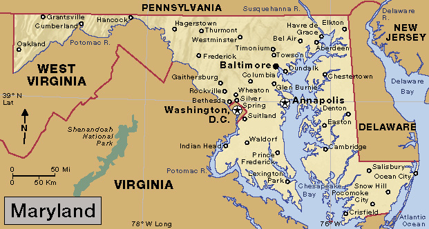
Washington lies on the Potomac River in the eastern part of the United States, between Maryland and Virginia. It is the only American city or town that is not part of a state. Washington also differs from most American cities because it has no factories or traditional manufacturing enterprises. It was founded to house the federal government.
Washington was the first city in the United States to be designed before it was built. The nation’s first president, George Washington, chose the site in 1791, and he hired Pierre Charles L’Enfant, a French engineer, to plan the city. The federal government moved there from Philadelphia in 1800. The city’s commissioners named the city for George Washington and called the larger area the District of Columbia. The city now covers the entire district, and it is sometimes called simply D.C.
The Constitution of the United States gave Congress the power to govern Washington. For much of the city’s history, its leaders were appointed by the president. In 1973, Congress granted Washingtonians the right to elect their local officials. However, Washington does not have a voting representative in Congress. Many Washington residents feel it is unjust for them to be required to pay federal taxes and not have a congressional vote.
Visitor’s guide
Most of Washington’s tourist attractions are in the area the city’s people call the monumental core. This area stretches from the U.S. Capitol to the Potomac River along a narrow park called the Mall. It extends several blocks on either side of the Mall. This section of the article describes the main features of the monumental core. The last part of this section mentions interesting sights in other parts of the city and its suburbs.
Many of Washington’s points of interest also have separate articles in World Book. See the list of Related articles at the end of this article.
Capitol Hill
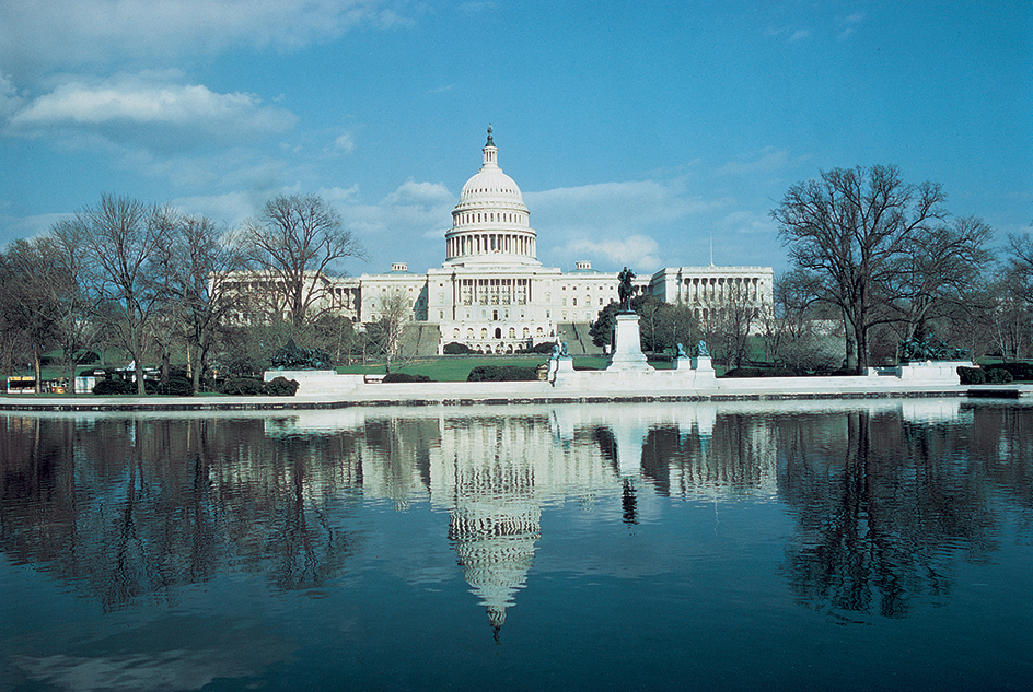
Capitol Hill rises 88 feet (26.8 meters) near the center of Washington. Pierre L’Enfant chose the hill as the site for the U.S. Capitol. In addition to the Capitol, several large government buildings stand on the hill. They include congressional office buildings, the Library of Congress, the Supreme Court, and the conservatory of the U.S. Botanic Garden. Union Station and the Folger Shakespeare Library are also on Capitol Hill.
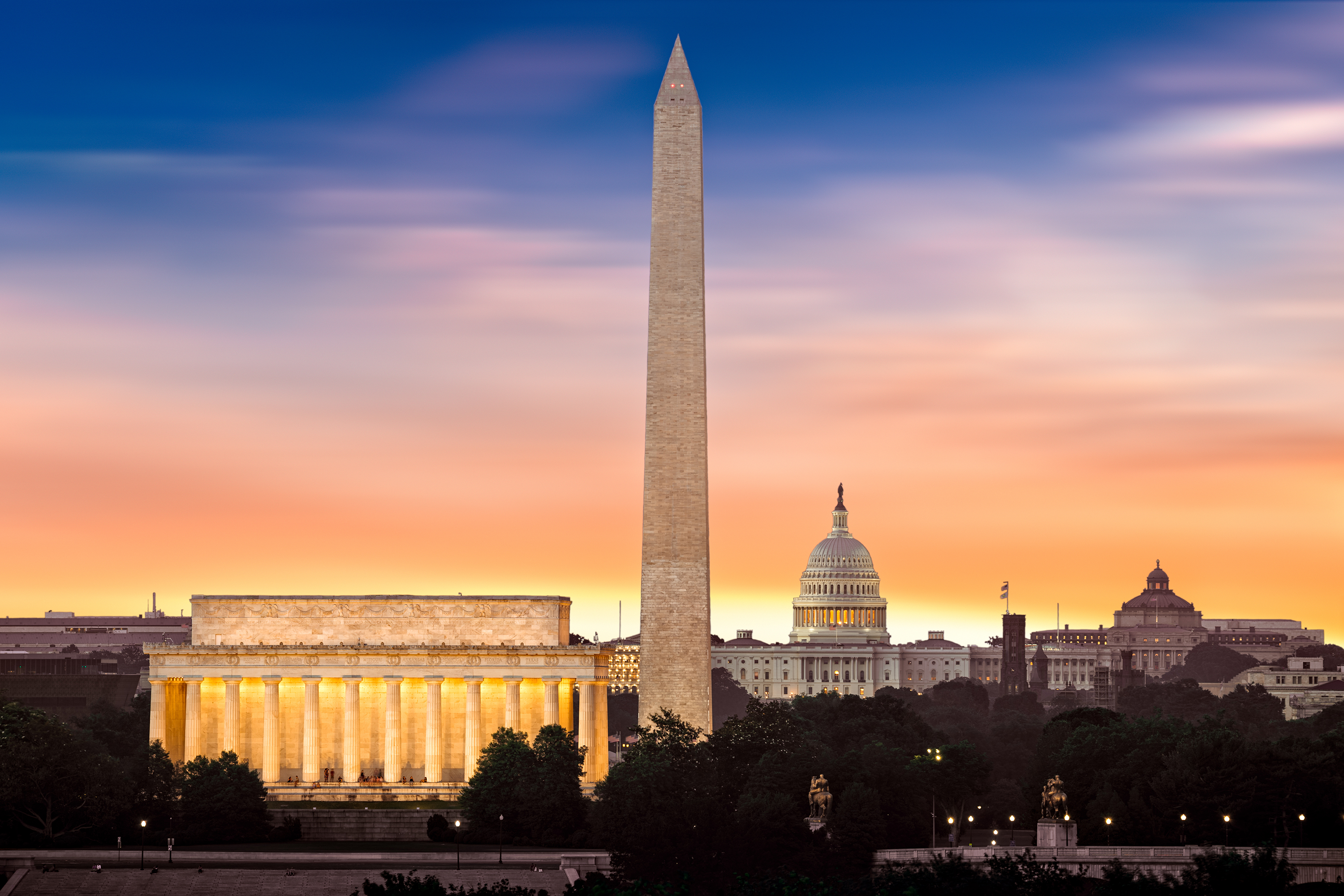
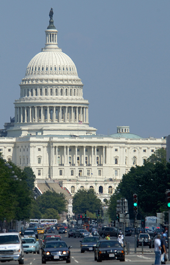
United States Capitol
is the place where members of Congress meet to propose and adopt legislation. The Capitol ranks among the nation’s most magnificent buildings. Tall Corinthian columns and an enormous dome beautify its white marble exterior. The bronze Statue of Freedom 191/2 feet (5.94 meters) high stands on top of the dome. The Capitol, including the statue, rises nearly 300 feet (91 meters) above ground.
The Capitol has 540 rooms. Many of them contain beautiful paintings, sculptures, and wall carvings that portray events and people important in American history. These artworks and the bustle of lawmakers and their staff members help convey to visitors a strong sense of purpose and patriotism. Visitors may attend sessions of Congress to hear the debates and watch democracy in action.
Congressional office buildings.
Six large buildings as well as several smaller annexes provide office space for the members of Congress. The Dirksen, Hart, and Russell Senate office buildings are north of the Capitol. The Cannon, Longworth, and Rayburn House of Representatives office buildings are south of the Capitol. The members of Congress welcome visits to their offices by the people they represent.
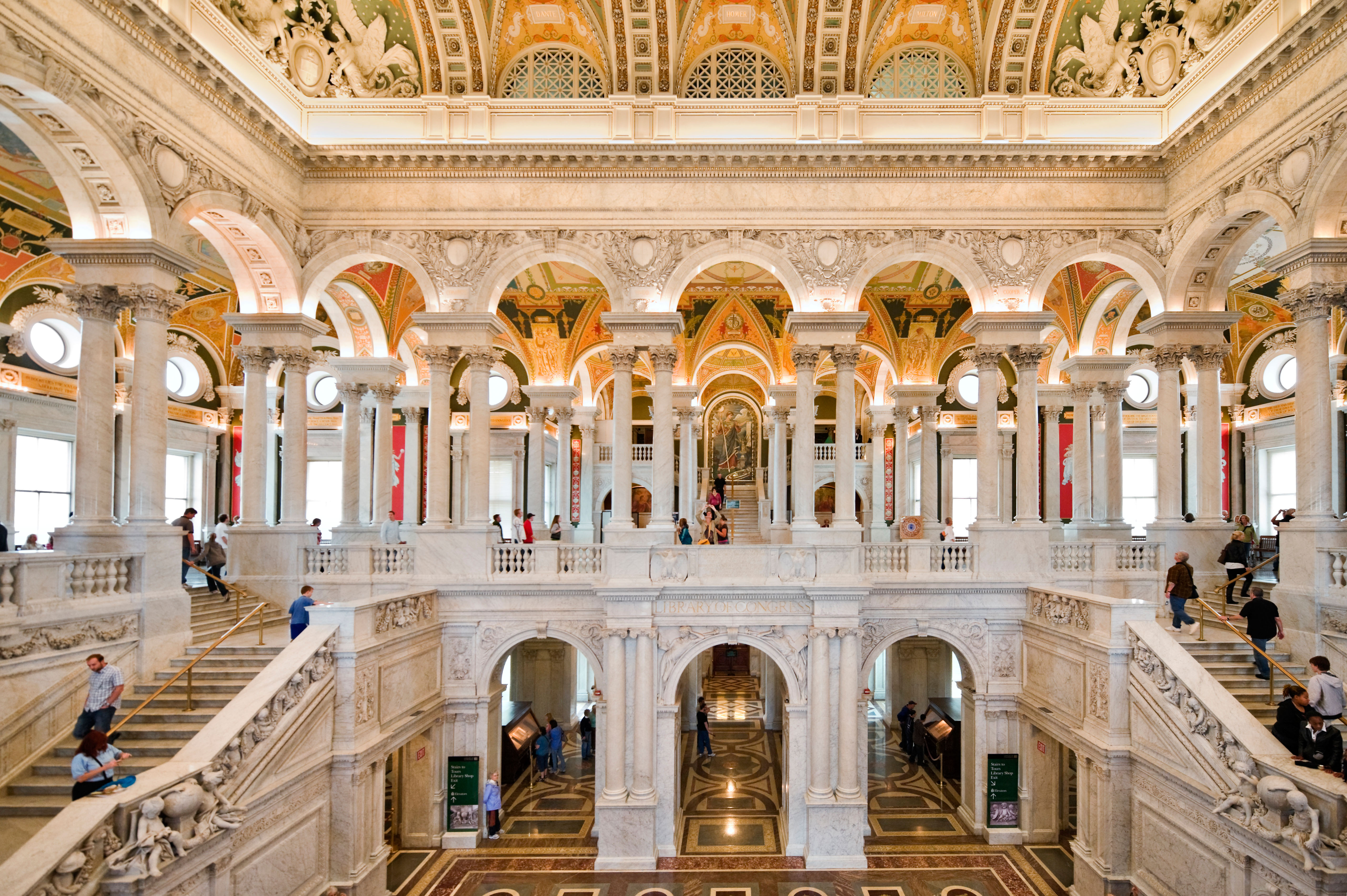
Library of Congress
holds about 175 million items and research materials in 470 languages. It serves as a legislative and research library for Congress and as a center for scholars. It is the copyright agency of the United States and the national library. It is housed in three buildings east of the Capitol—the Jefferson, Adams, and Madison buildings.
Highlights of the library’s collection include American Civil War photographs by Mathew Brady, two copies of Abraham Lincoln’s Gettysburg Address handwritten by Lincoln, and a Gutenberg Bible printed in the 1450’s. The library also owns more than 6,000 books that once belonged to Thomas Jefferson. Jefferson sold his private library to the Library of Congress in 1815. It replaced the library’s original collection, which was destroyed by British soldiers in August 1814 during the War of 1812.
Supreme Court
stands directly east of the Capitol. In this building, the nine justices of the Supreme Court of the United States decide on the constitutionality of laws, government practices, and the decisions of lower courts. The building’s white marble exterior resembles a Greek temple. The room where the justices hear cases is decorated with long red drapes, copper gates, and marble columns. Visitors may attend sessions of the court, which begin each year on the first Monday of October and usually end in June.
United States Botanic Garden
is southwest of the Capitol. It exhibits thousands of varieties of plants, including many rare species.
Union Station,
north of the Capitol, is Washington’s railroad station, a subway stop, and the headquarters for Amtrak. The huge 1907 building is also a popular tourist attraction. Its many shops, restaurants, and special exhibits and other events attract millions of visitors every year.
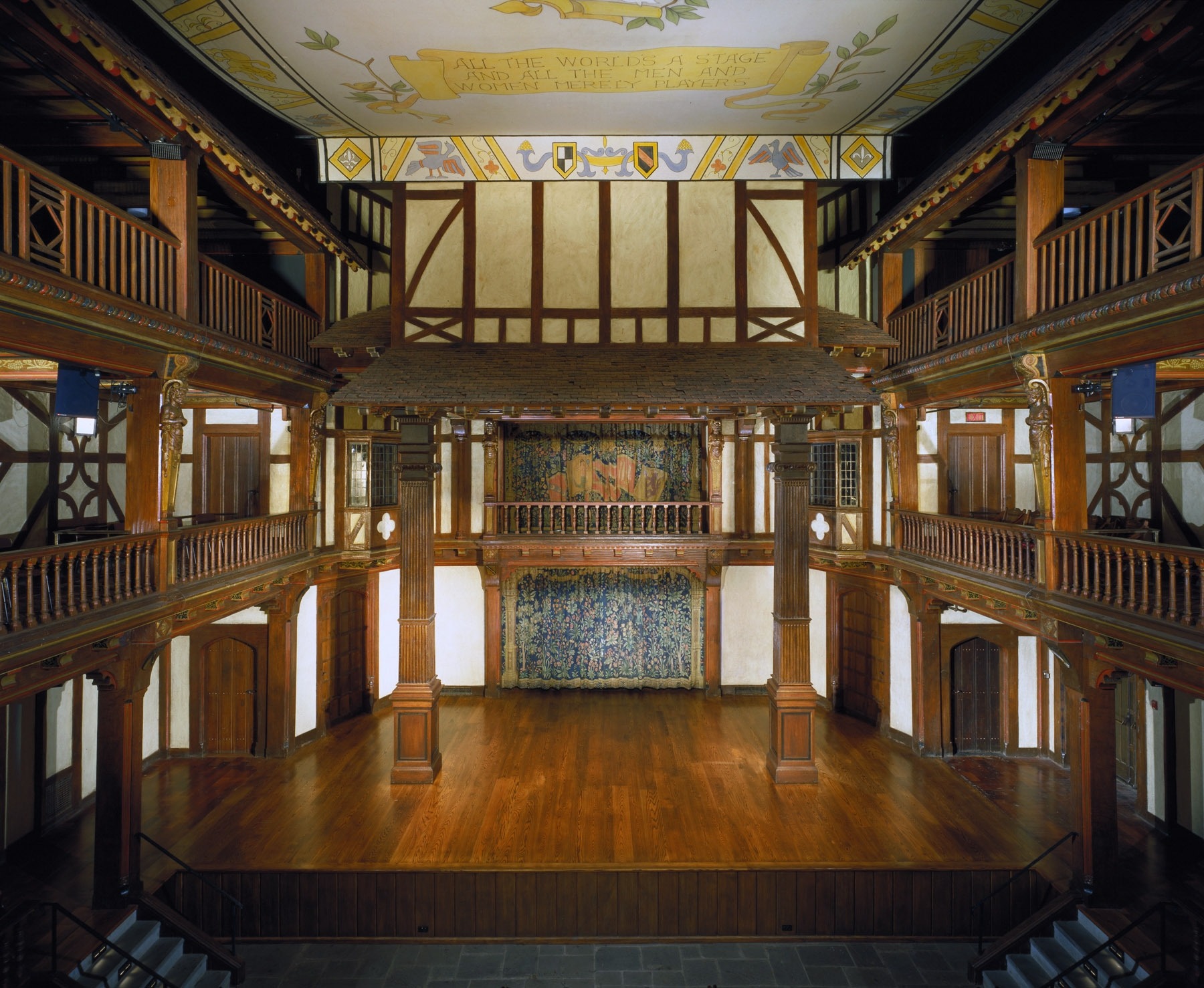
Folger Shakespeare Library,
east of the Capitol, houses the world’s most important collection of works by and about English playwright William Shakespeare. Only scholars may do research in the library, but exhibits of rare books and manuscripts are open to the public. The Folger presents productions of Shakespeare’s plays at a small theater in the library.
The Mall
The Mall is a narrow park 2 miles (3 kilometers) long that stretches west from the Capitol to the Lincoln Memorial. It serves as the nation’s “front yard.” The Mall is the location of a number of Smithsonian museums and important memorials. It is also the site of many festivals, demonstrations, and public celebrations. 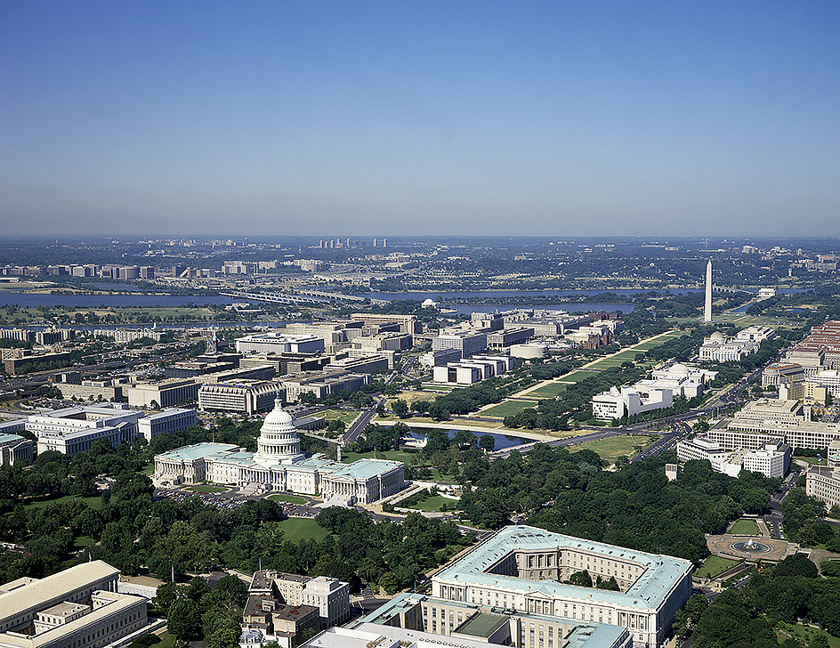
Smithsonian museums.
The Smithsonian Institution is a government corporation that operates cultural, educational, and scientific facilities throughout Washington. It was established by an act of Congress in 1846 and funded by James Smithson, a British scientist who had never visited the United States. Smithson left his fortune to the nation for the “increase and diffusion of knowledge.” The Smithsonian’s buildings on the Mall are listed here in alphabetical order.
The Arthur M. Sackler Gallery specializes in Asian art.
The Arts and Industries Building, formerly known as the National Museum, was closed for renovation in 2004. It reopened in 2015 as a venue for special events.
The Freer Gallery of Art is noted for its collection of American paintings of the 1800’s and 1900’s, particularly the works of James McNeill Whistler. The Freer also has an important collection of Asian art.
The Hirshhorn Museum and Sculpture Garden features modern paintings and sculpture.
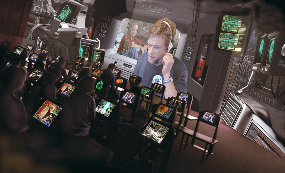
The National Air and Space Museum has the world’s largest collection of historic aircraft and spacecraft. Its exhibits include the plane of the Wright brothers, in which Orville Wright made the first successful flight; the Spirit of St. Louis, in which Charles Lindbergh made the first solo flight across the Atlantic Ocean; and the Apollo 11 spacecraft, in which American astronauts traveled to the moon. 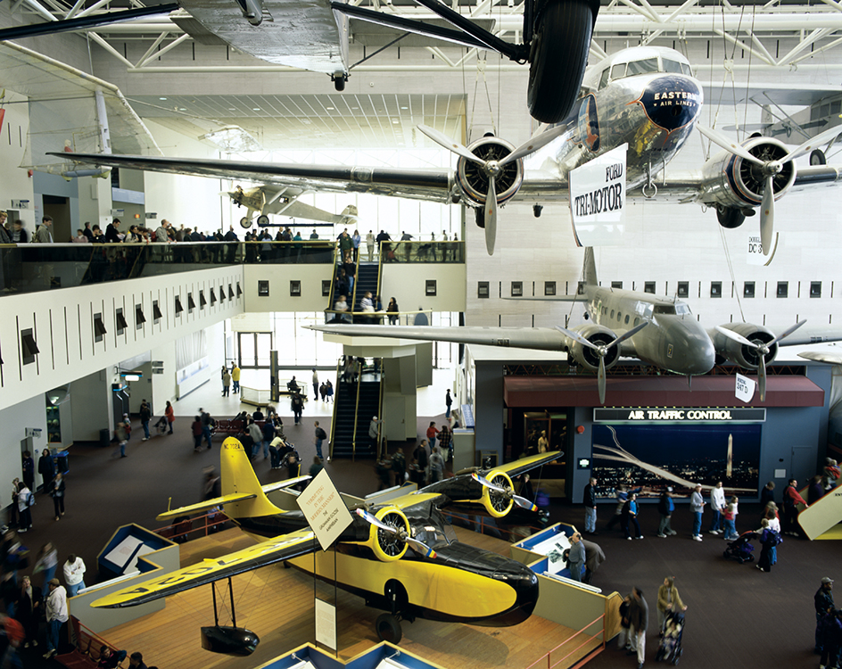
The National Museum of African American History and Culture focuses on African American life and culture, dating from the hardships of slavery to the challenges and achievements of contemporary times.
The National Museum of African Art is dedicated to the preservation of African art and culture.
The National Museum of American History houses the Star-Spangled Banner, the flag that inspired Francis Scott Key to write the national anthem. The museum has exhibits on the presidents and first ladies of the United States and numerous collections related to American popular culture.
The National Museum of the American Indian focuses on presenting the historical and contemporary cultures and cultural achievements of Indigenous (native) Americans.
The National Museum of Natural History, one of the world’s most popular museums, features skeletons of dinosaurs, a gem collection that includes the Hope Diamond, and an insect zoo.
The Smithsonian Institution Building, known as the Castle, was the Smithsonian’s original building. The red sandstone castlelike structure is a replica of Norman architecture of the 1100’s. Once a museum, the building now houses administrative offices, the Smithsonian Information Center, and the burial place of James Smithson.
Several Smithsonian museums are in other parts of Washington. The Anacostia Community Museum is a center for the preservation of African American art and culture. The National Portrait Gallery displays a collection of paintings of important people in American history. The National Postal Museum focuses on the history of American postal delivery and stamp design. The Smithsonian American Art Museum includes collections of American art from the 1700’s to the present. The Renwick Gallery of the Smithsonian American Art Museum features American crafts.
The National Zoological Park is also part of the Smithsonian Institution. The zoo houses rare pandas and hundreds of other animals.
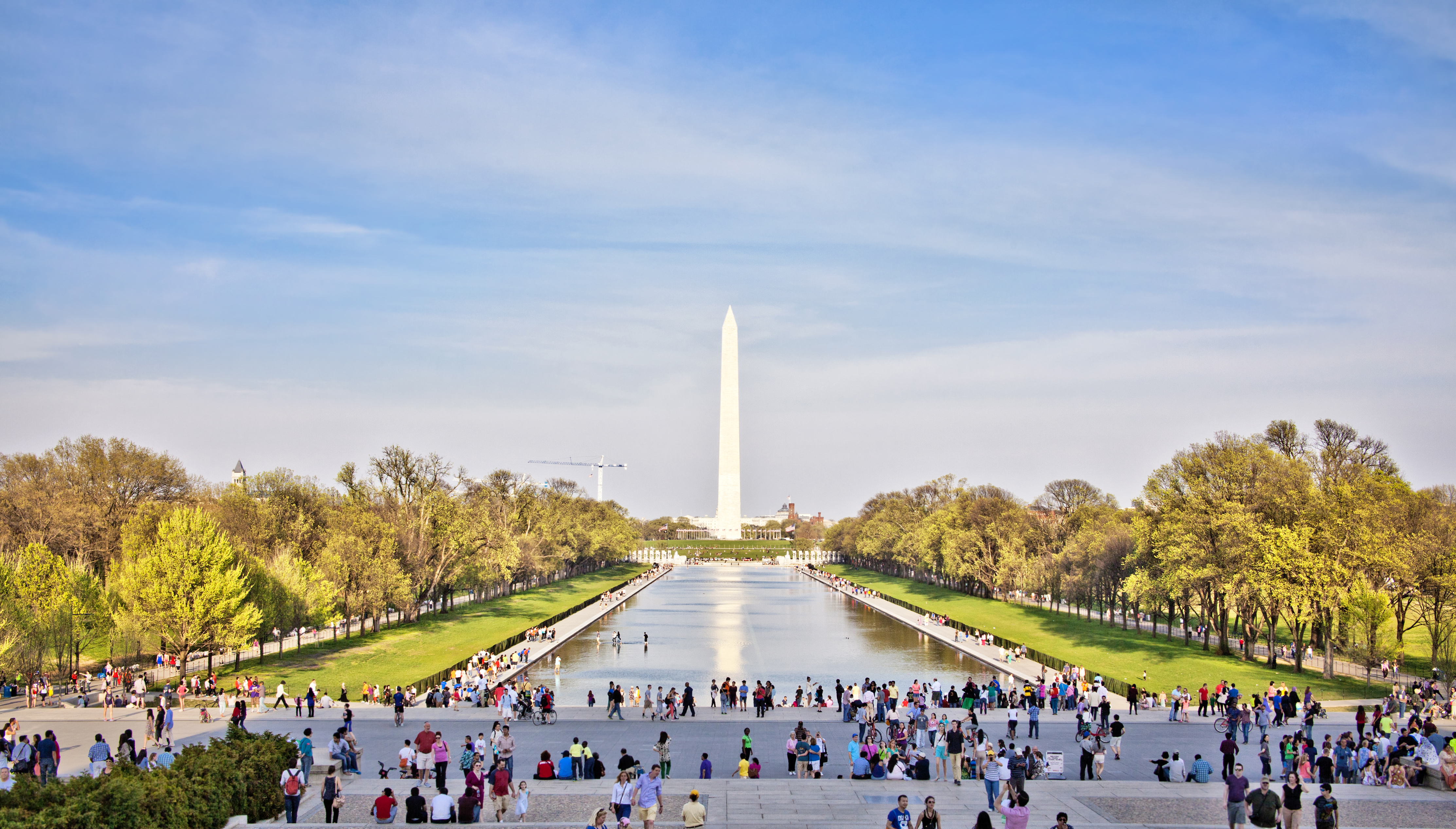
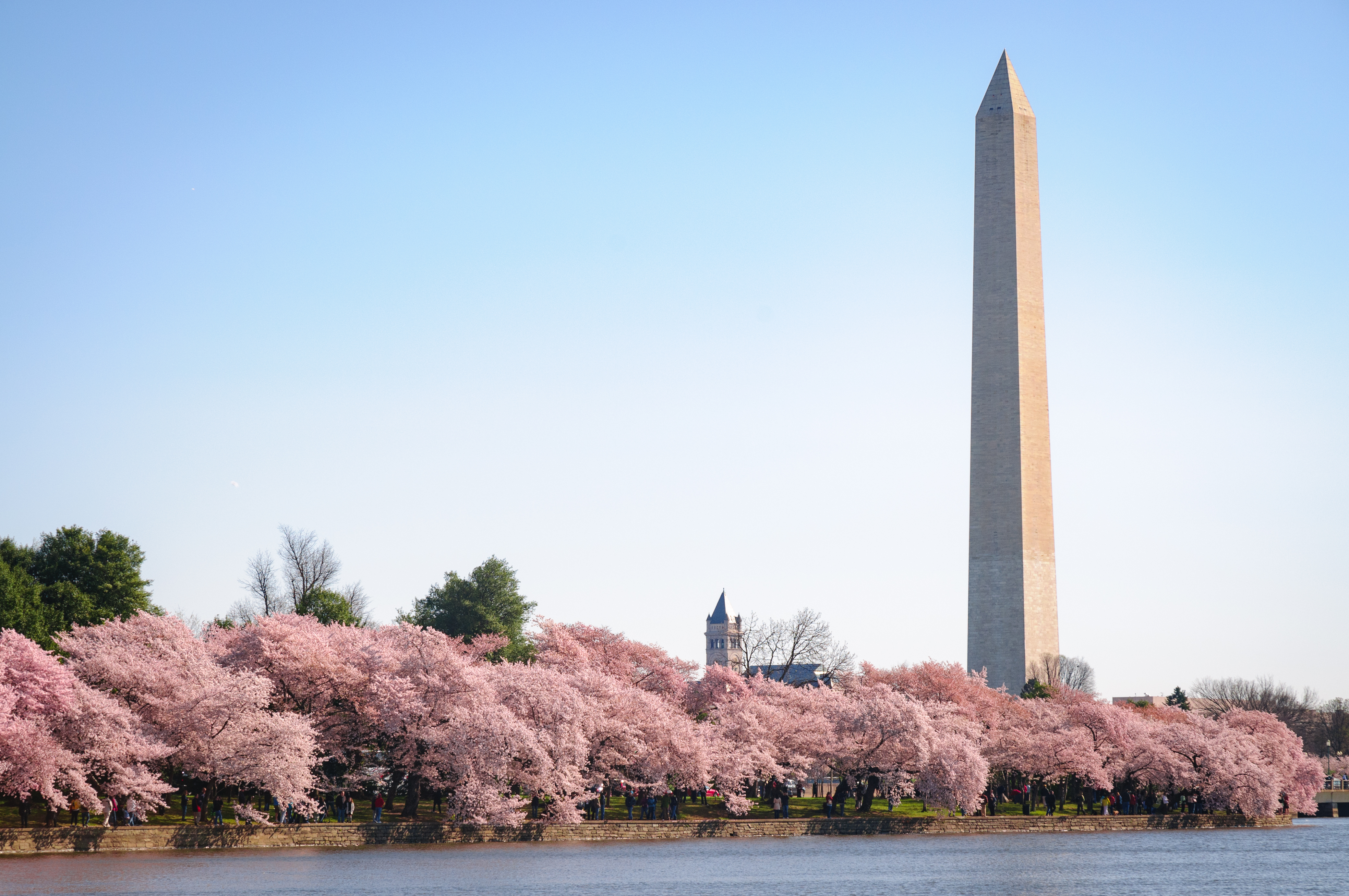
Washington Monument
is a towering, slender, white marble obelisk (pillar) dedicated to the memory of George Washington. The tallest structure in Washington, it stands about 555 feet (169 meters) tall. From the top, visitors can see much of the Washington area.
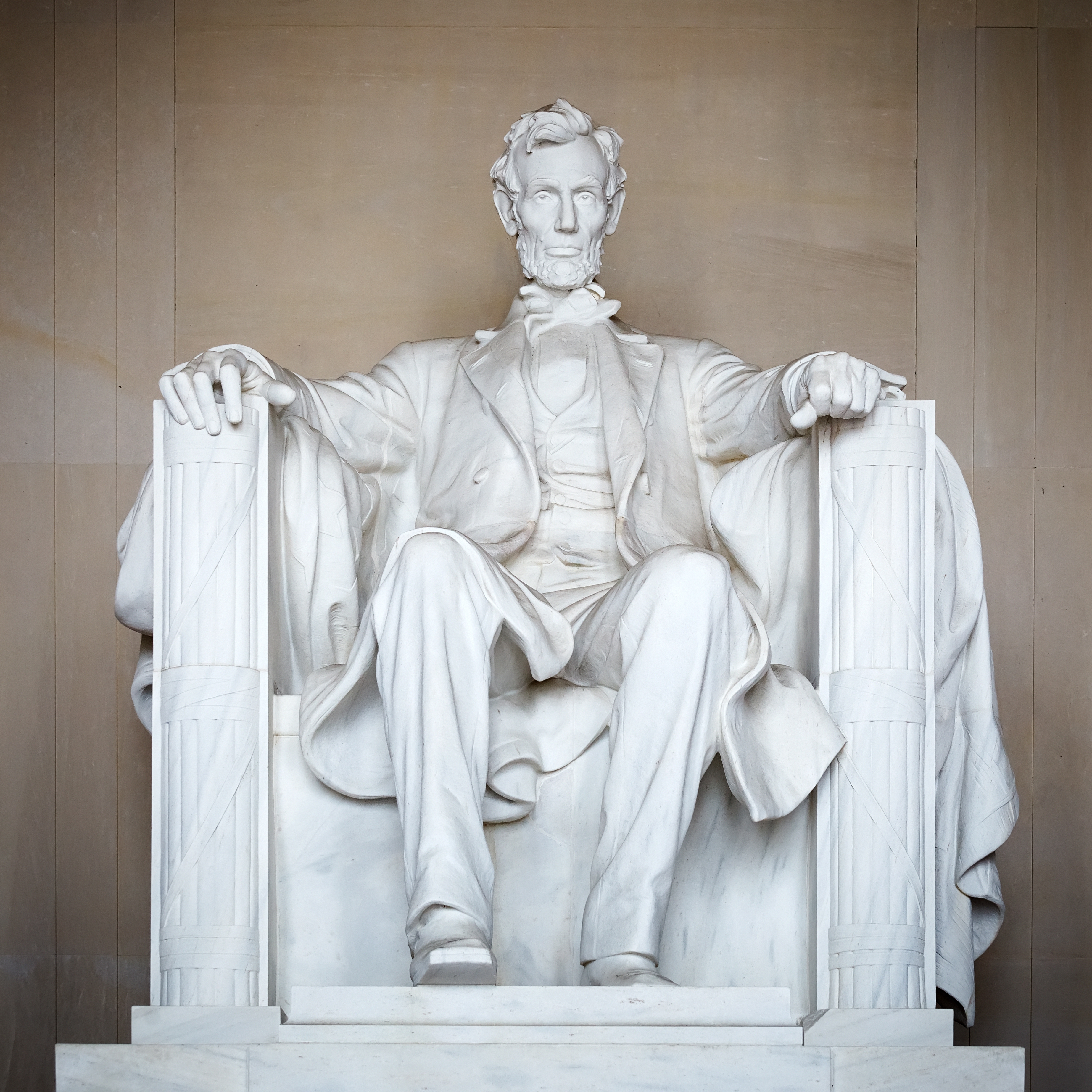
Lincoln Memorial
is a white marble monument that honors Abraham Lincoln. On the outside, 36 Doric columns, one for each state in the Union at the time of Lincoln’s death, support the roof. Inside is a majestic marble sculpture of Lincoln seated in a chair. Quotations from Lincoln’s writings appear on the interior walls.
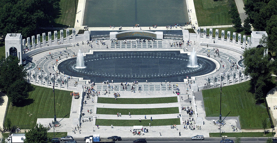
National World War II Memorial
honors the millions of men and women who served in the U.S. armed forces in World War II (1939-1945) as well as the millions more who helped on the home front. Fifty-six small pillars representing the District of Columbia and the U.S. states and territories of the war period surround a sunken pool and granite plaza. Two large arches symbolize the two theaters of the war—Europe and northern Africa, and Asia and the Pacific. A curved wall is covered with gold stars representing those who died in the war.
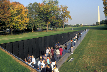
Vietnam Veterans Memorial,
east of the Lincoln Memorial, is dedicated to those who served in the Vietnam War (1957-1975). It includes two black granite walls on which are inscribed the names of all Americans who died in the war or who remain classified as missing in action. Many visitors leave flowers or other remembrances of their loved ones who served in Vietnam. The memorial also includes two bronze sculptures, one of three servicemen and the other of battlefield nurses.
Korean War Veterans Memorial,
east of the Lincoln Memorial, is a monument to those who served in the Korean War (1950-1953). It features 19 large stainless steel sculptures of American servicemen and a black granite wall that reflects the sculptures. The wall has engraved images of about 2,500 nurses, mechanics, and other military personnel who served in Korea.
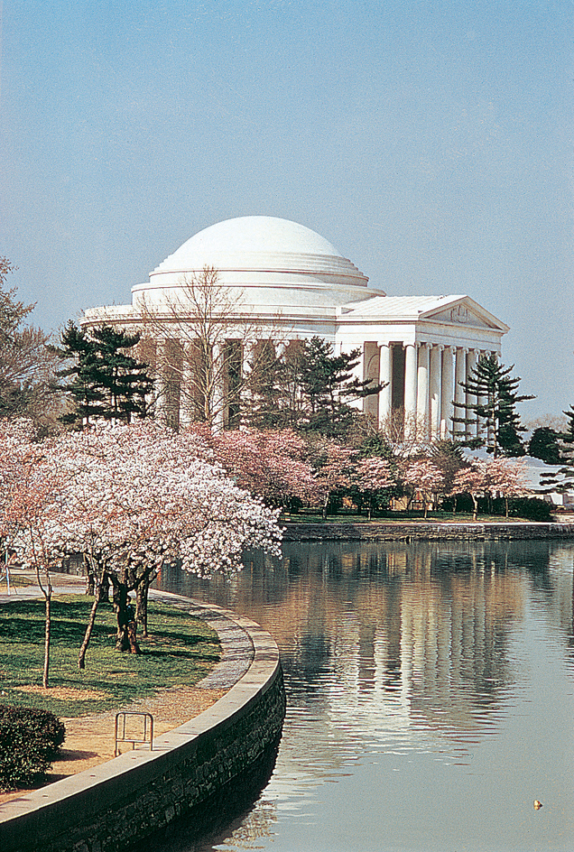
The Tidal Basin
The Jefferson Memorial, the Roosevelt Memorial, and the Martin Luther King, Jr. National Memorial stand near the Tidal Basin, a lagoon that adjoins the Mall south of the Washington Monument. The Tidal Basin is surrounded by more than 3,000 Yoshino cherry trees, a gift from the mayor of Tokyo, Japan, in 1912 to memorialize Japanese-American friendship. Since 1934, the blossoming of the trees in late March or early April each year has been celebrated with the Cherry Blossom Festival.
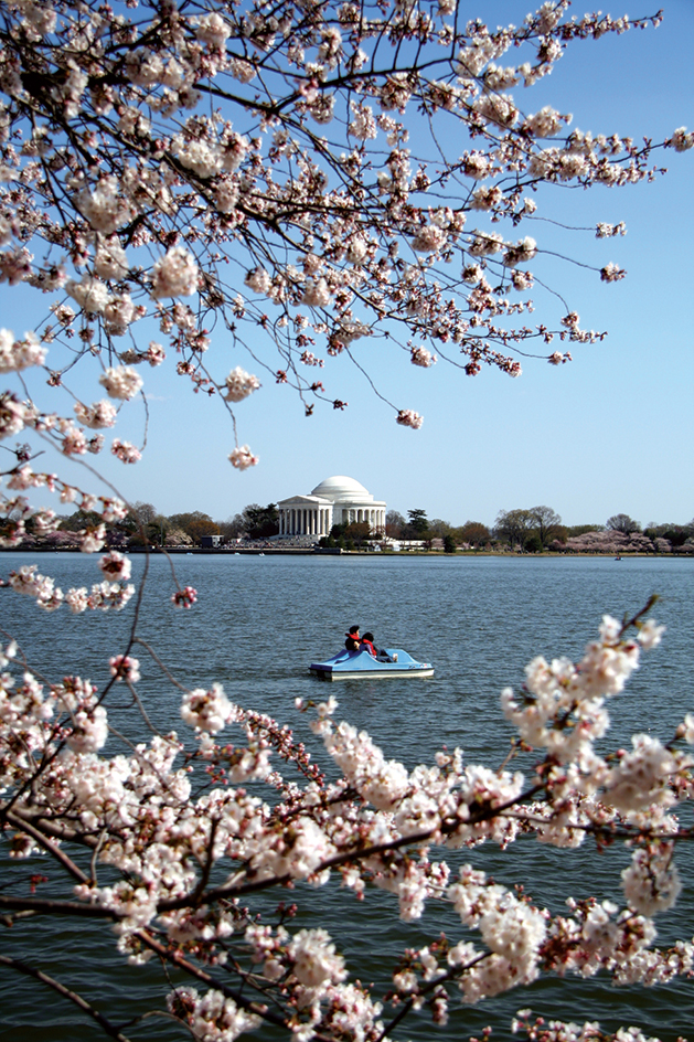
Jefferson Memorial,
on the south side of the Tidal Basin, is dedicated to Thomas Jefferson. The design of the circular white marble building is based on the Classical style of architecture. Jefferson introduced the style to the United States when he designed and built his own home, Monticello. A bronze statue of Jefferson and quotations from his writings are inside the monument.
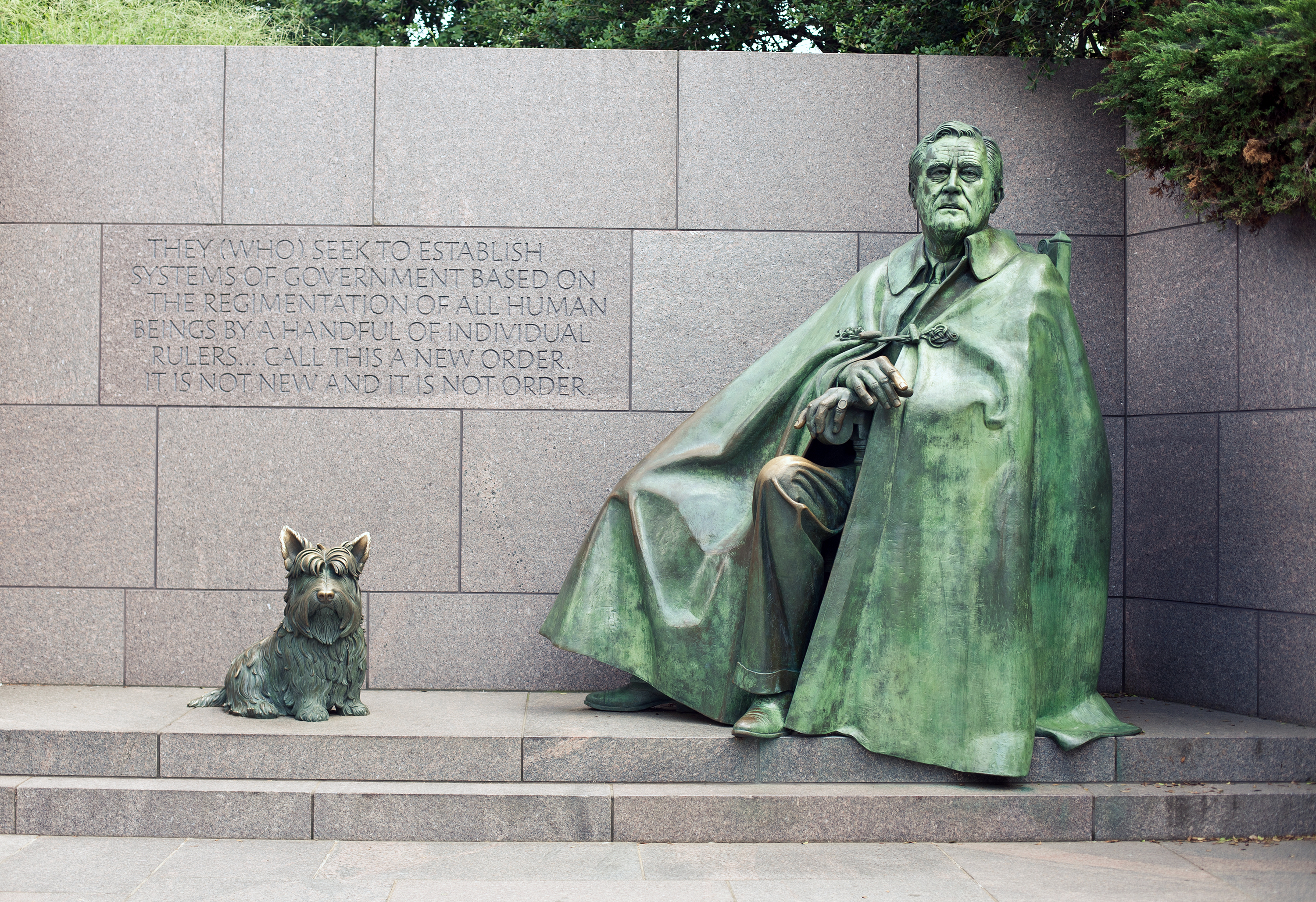
Franklin Delano Roosevelt Memorial,
which stands on the west side of the Tidal Basin, honors Franklin D. Roosevelt. It is also called the Roosevelt Memorial or the FDR Memorial. It includes four outdoor “rooms,” each dedicated to one of Roosevelt’s four terms as president. The monument spreads out over 7 1/2 acres (3 hectares). Sculptures depict the Great Depression and other events of Roosevelt’s presidency.
Martin Luther King, Jr. National Memorial
honors the life and work of the civil rights leader Martin Luther King, Jr. The memorial includes a 30-foot (9-meter) sculpture of King and a curving wall with quotations from many of King’s speeches.
North of the Mall
North of the Mall stand a number of massive office buildings, along or near Pennsylvania Avenue. This broad, treelined street crosses the city from southeast to northwest and connects the Capitol with the White House. It is sometimes known as “America’s Main Street,” and it serves as Washington’s main parade route. Major demonstrations take place on the street as well as races to fund medical research.
The White House ranks as the most important building in this area. Some of the other buildings house offices of the executive branch of the federal government. Several national and international organizations have their headquarters near the federal buildings. These include the American Red Cross, Daughters of the American Revolution (DAR), the National Academy of Sciences, the International Monetary Fund, the Organization of American States, and the World Bank. Also nearby is a major tourist attraction, Ford’s Theatre.
White House,
at 1600 Pennsylvania Avenue NW, has served as the home and office of every United States president except George Washington. The building is constructed of white sandstone and stands in an 18-acre (7.3-hectare) park. Five of its 132 rooms are open to the public. These rooms—the Blue, East, Green, and Red rooms and the State Dining Room—are decorated with magnificent art and elegant furnishings. The president’s offices and family quarters are not open to tourists.
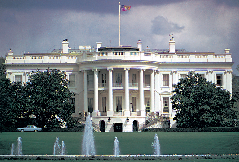
Two parklike areas border the White House grounds. Lafayette Square lies to the north, and the Ellipse lies to the south. Blair House, a mansion on the west side of Lafayette Square, serves as a guesthouse for high-ranking international officials visiting the president. President Harry S. Truman lived in Blair House from 1948 to 1952 while the White House was being renovated.
Executive branch buildings.
The Eisenhower Executive Office Building (formerly the Old Executive Office Building) is west of the White House, and the New Executive Office Building is north of it. The employees of the Office of Management and Budget and other presidential staff members work in these buildings. The Department of the Treasury is directly east of the White House.
Several large office buildings for the executive branch stand close together on the south side of Pennsylvania Avenue between the White House and the Capitol. This group of buildings is called Federal Triangle because it consists of federal government buildings grouped in a triangle. Federal Triangle includes the Department of Commerce, Department of Justice, Environmental Protection Agency, Federal Trade Commission, Internal Revenue Service, National Archives and Records Administration, and U.S. Customs and Border Protection. The Department of Labor and the Federal Bureau of Investigation (FBI) lie north of Pennsylvania Avenue. The departments of State and Interior are southwest of the White House, in a neighborhood known as Foggy Bottom.
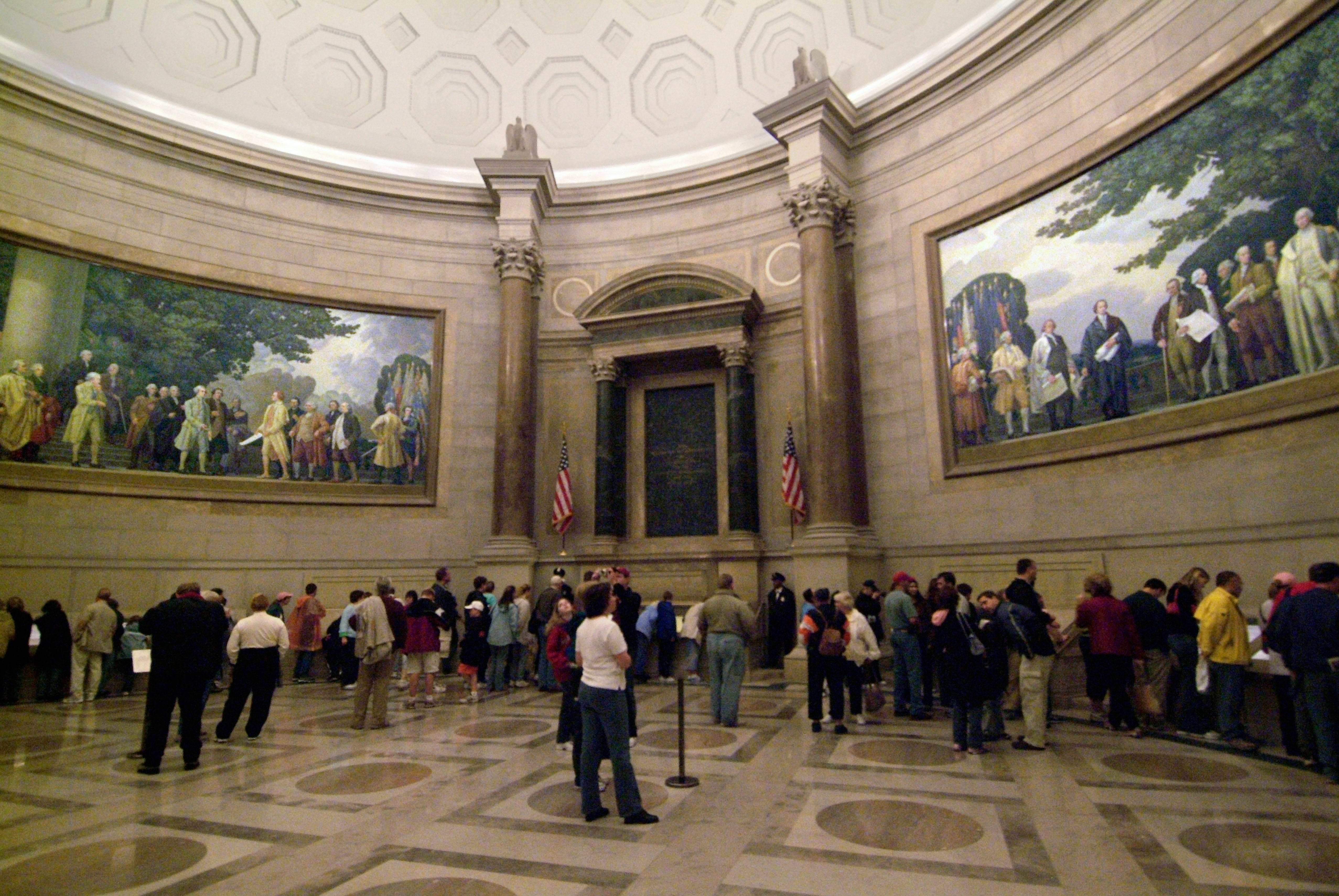
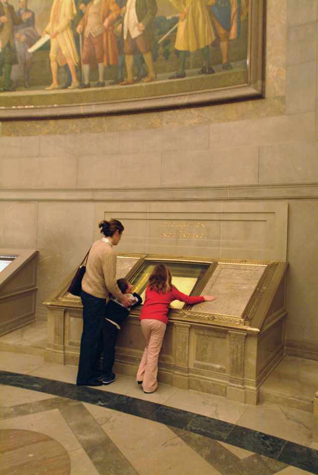
The National Archives Building, which stores government documents, is popular with tourists. It displays three of the most important documents in American history—the Declaration of Independence, the Constitution of the United States, and the Bill of Rights.
Ford’s Theatre,
is the playhouse where Abraham Lincoln was shot. It stands 11/2 blocks north of Pennsylvania Avenue, between the Capitol and the White House. The theater, which still offers live performances of touring dramas and musicals, houses a collection of items related to Lincoln’s life and death. Petersen House, the house where Lincoln died, is across the street from the theater.
South of the Mall
South of the Mall stand several government office buildings. They include the offices of the United States Postal Service and of five executive departments—Agriculture, Education, Energy, Health and Human Services, and Housing and Urban Development.
The Dwight D. Eisenhower Memorial also stands south of the Mall, just southwest of the Capitol. The memorial features a sculpture garden with scenes from the life of the U.S. Army general and 34th president.
In addition, the Bureau of Engraving and Printing (BEP) is south of the Mall. This popular tourist attraction is the place where government workers engrave and print the nation’s paper money.
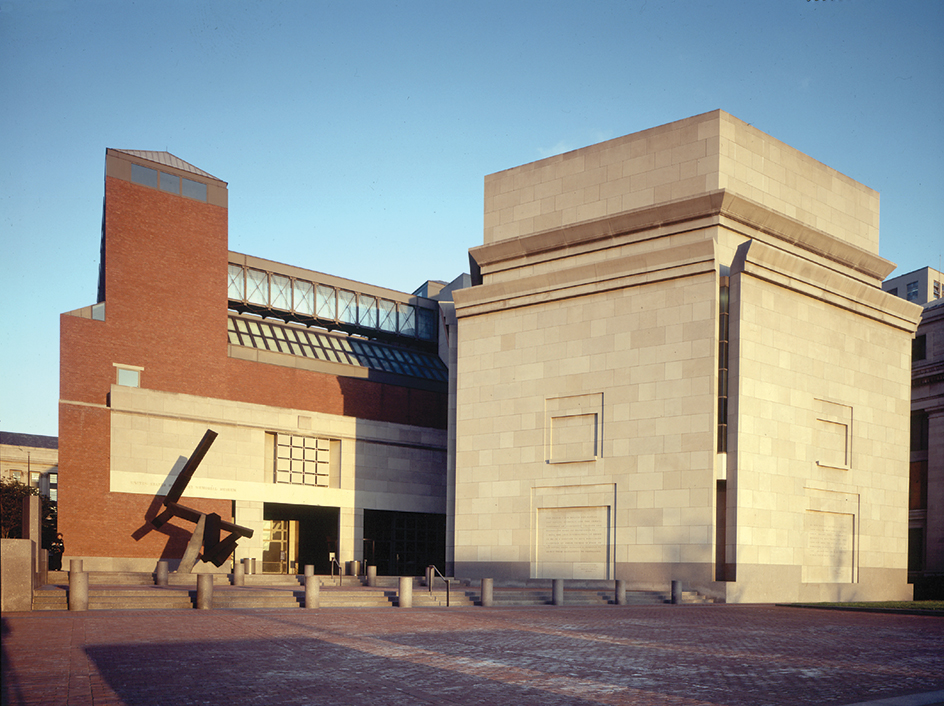
Next door to the BEP is the U.S. Holocaust Memorial Museum. This museum honors the millions of Jews and others murdered by the Nazis during World War II.
Other points of interest
Other points of interest draw visitors to other parts of Washington and its suburbs.
John F. Kennedy Center for the Performing Arts
borders the Potomac River near the Lincoln Memorial. It has three large theaters and a number of smaller spaces that host dramas, ballets, operas, symphonies, and other music and dance performances.
Watergate,
a complex north of the Kennedy Center, includes condominiums, offices, a hotel, and shops. Watergate became internationally famous in 1972 when campaign workers for President Richard M. Nixon, a Republican, were caught breaking into Democratic political headquarters there. The break-in marked the start of a major American political scandal that led to Nixon’s resignation from office.
Other Washington museums.
The Phillips Collection includes American and European paintings from the 1700’s to the present. The National Museum of Women in the Arts exhibits the work of women artists of all periods and nationalities. The Textile Museum exhibits textiles dating from 3000 B.C. to the present. Woodrow Wilson House, the home that the 28th president lived in after he left office, is a national historic landmark.
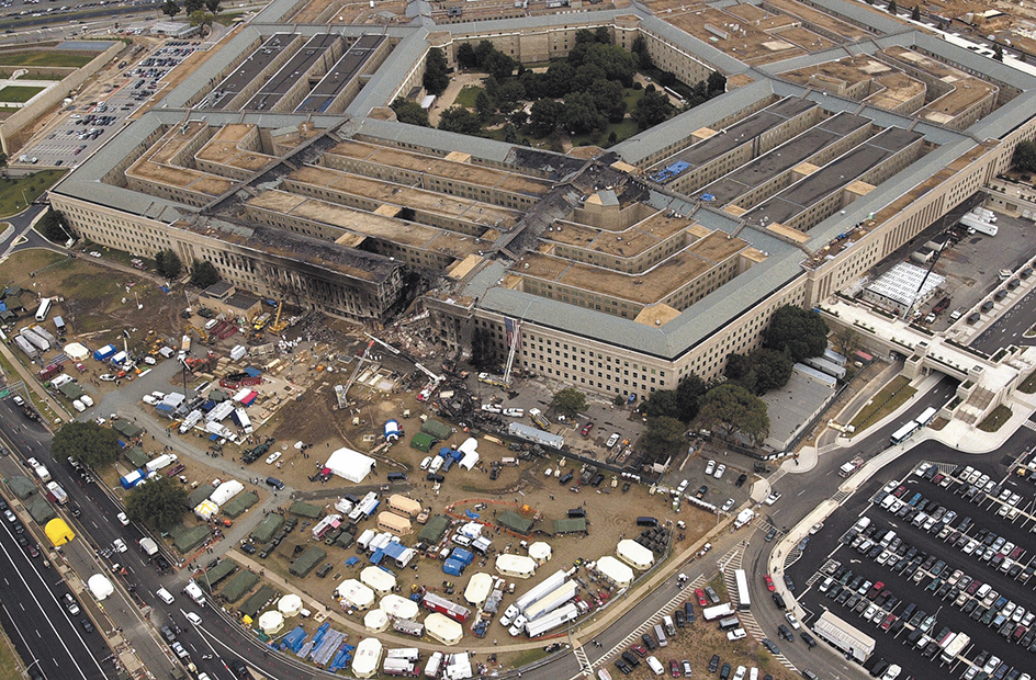
The Pentagon,
the headquarters of the Department of Defense, is one of the world’s largest office buildings. It covers 29 acres (11.7 hectares) in Arlington, Virginia, across the Potomac from Washington.
Arlington National Cemetery,
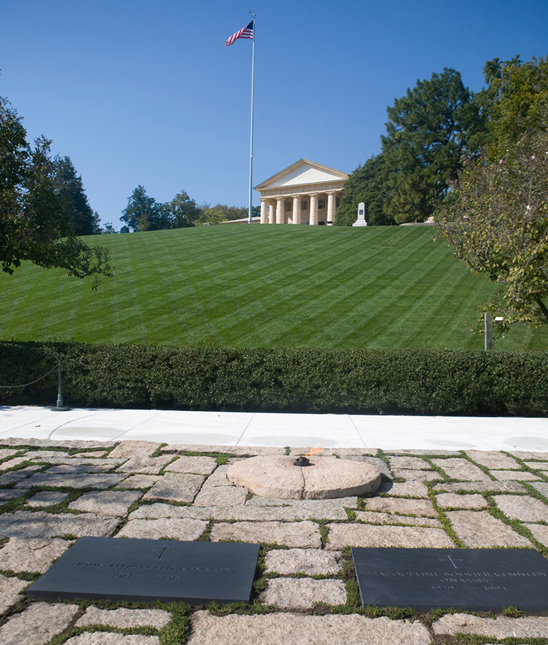
which lies northwest of the Pentagon in Arlington, contains the graves of thousands of men and women who served in the U.S. armed forces. It includes the Tomb of the Unknowns, where three unidentified servicemen who died in action are buried. They represent all the unidentified members of the armed forces who gave their lives for their country. The cemetery also includes the graves of President William Howard Taft; President John F. Kennedy; Kennedy’s wife, Jacqueline; and Kennedy’s two younger brothers, Senators Robert F. Kennedy and Edward M. Kennedy.
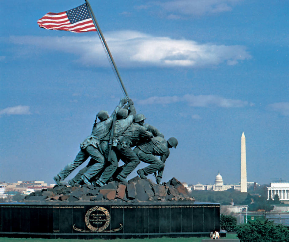
Marine Corps War Memorial,
also known as the Iwo Jima Memorial, is just north of Arlington Cemetery. It features one of America’s most famous monuments, a dramatic bronze sculpture of five marines and a Navy medical corpsman raising the American flag on the island of Iwo Jima (now Iwo To) during World War II.
Mount Vernon,
the home of George Washington, is in northern Virginia, about 15 miles (24 kilometers) south of Washington. The first president’s grave is there.
Architectural styles.
Many visitors enjoy the rich and varied architecture of the city’s buildings and monuments. Many structures, including the Capitol, Supreme Court, and Lincoln Memorial, are built in the Neoclassical style or the Greek Revival style. These styles were derived from the traditions of ancient Greece and Rome.
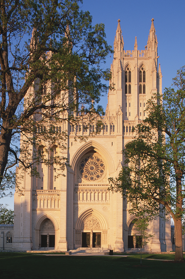
Washington National Cathedral, an Episcopal church at Massachusetts and Wisconsin Avenues NW, was built in the Gothic style of medieval Europe. The Basilica of the National Shrine of the Immaculate Conception, at 4th Street and Michigan Avenue NE, has elements of Byzantine and Romanesque architecture. The Islamic Center on Massachusetts Avenue NW is an outstanding example of Muslim architecture.
Many buildings in Georgetown, a neighborhood west of the White House, provide examples of colonial American residential architecture. Other sections of the city have fine examples of many other historic and modern styles of architecture. However, no building in Washington may be built taller than the 13-story Washington Monument. As a result, Washington, unlike most other large cities, has no skyscrapers.
The city
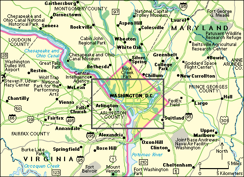
Washington, D.C. lies along the northern bank of the Potomac River. The state of Maryland borders Washington on the northwest, northeast, and southeast. Virginia lies across the Potomac River to the southwest. Suburban communities of Maryland and Virginia surround Washington.
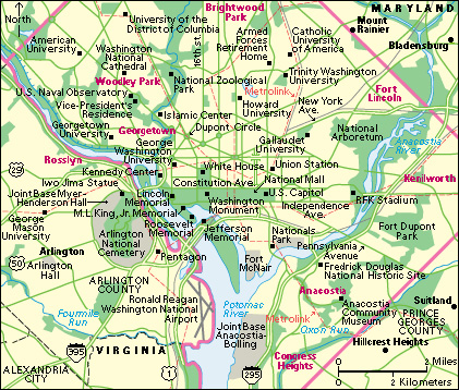
Pierre L’Enfant’s city plan created a large grid, with the U.S. Capitol at its heart. The city is divided into four quadrants (fourths of a circle) by the streets that extend directly north, south, east, and west of the Capitol—North Capitol Street, South Capitol Street, East Capitol Street, and the Mall. The quadrants are Northwest (NW), Southwest (SW), Northeast (NE), and Southeast (SE). All four quadrants have the same basic street pattern. Streets that run north-south are numbered, beginning at the Capitol. The east-west streets are letters of the alphabet, beginning at the Capitol.
Overlaid onto the grid are 50 diagonal avenues, each named for a U.S. state. The avenues closest to the Capitol are named for the original 13 states, and those farther away are named for the states that joined the Union later. Where two or more avenues intersect there is a circle. Many of the circles have lovely parks.
Northwest
includes that part of Washington between North Capitol Street and the Potomac River. It covers about the half the city’s area and is its largest section. Northwest is also Washington’s main center of cultural, economic, and government activity.
Northwest Washington holds the White House, a large number of federal office buildings, half the Smithsonian museums, and most of the foreign embassies. Washington’s main commercial and retail districts also lie in Northwest. North of the commercial area, Rock Creek Park winds through Northwest Washington in a north-south direction. The official residence of the vice president of the United States is near the park, on the grounds of the Naval Observatory on Massachusetts Avenue NW.
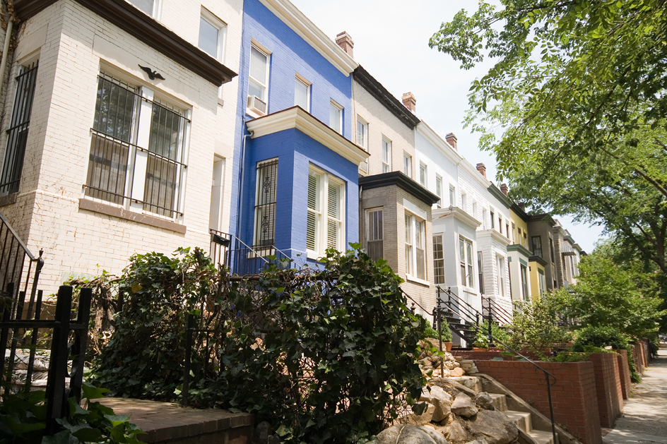
Large residential areas lie east and west of Rock Creek Park. Georgetown, which is west of the park, is the part of the district that was settled the earliest. It is famous for its beautiful old houses, many of which date from the late 1700’s and early 1800’s. Northwest includes a wide range of high-income, middle-income, and lower-income housing. It also includes five of the city’s leading universities—American, George Washington, Georgetown, and Howard universities and the University of the District of Columbia.
Northeast
lies between North Capitol and East Capitol streets. It covers about one-fourth of the city. Much of Northeast is residential, with large sections of lovely middle- and upper-middle-class housing as well as some lower-income areas. In this quadrant are Kenilworth Park and Aquatic Gardens, the National Arboretum, and Gallaudet University, a university for students who are deaf or hearing-impaired. This section also has an extensive complex of buildings owned by the Roman Catholic Church. The church’s holdings include the Catholic University of America, the Basilica of the National Shrine of the Immaculate Conception, Trinity Washington University, the Franciscan Monastery of the Holy Land in America (also called the Monastery of Mount St. Sepulchre), and the Saint John Paul II National Shrine. The Anacostia River cuts through Northeast.
Southeast
is the area between East Capitol and South Capitol streets. It covers just under one-fourth of the city’s area. Southeast includes the Washington Navy Yard, the headquarters of the United States Coast Guard and the U.S. Department of Homeland Security, and the grounds of St. Elizabeths Hospital. It also includes Fort Dupont Park and other parks established where forts stood during the American Civil War (1861-1865). There is an important commercial district on Pennsylvania Avenue SE. It includes Eastern Market, an old-fashioned farmers’ market where locally grown fresh fruits, vegetables, and flowers are sold. The Anacostia River flows through the heart of Southeast. The area south of the river is primarily residential, with mostly middle-class and low-income neighborhoods.
Southwest
is the city’s smallest quadrant, extending from South Capitol Street west to the Potomac River. It covers less than one-eighth of the district’s land area. Almost all of Southwest has been rebuilt since the 1950’s as part of a major urban renewal program. As a result, the housing stock in Southwest is considerably newer than in other parts of the city. Southwest also holds a substantial number of government office buildings, half the Smithsonian museums, Fort Lesley J. McNair, the National Defense University, and the sprawling Joint Base Anacostia-Bolling.
Metropolitan area.
The Washington-Arlington-Alexandria metropolitan area includes the District of Columbia, 6 cities in northern Virginia that are not part of a county—Alexandria, Fairfax, Falls Church, Fredericksburg, Manassas, and Manassas Park—11 counties in Virginia, 4 counties in Maryland, and 1 county in West Virginia.
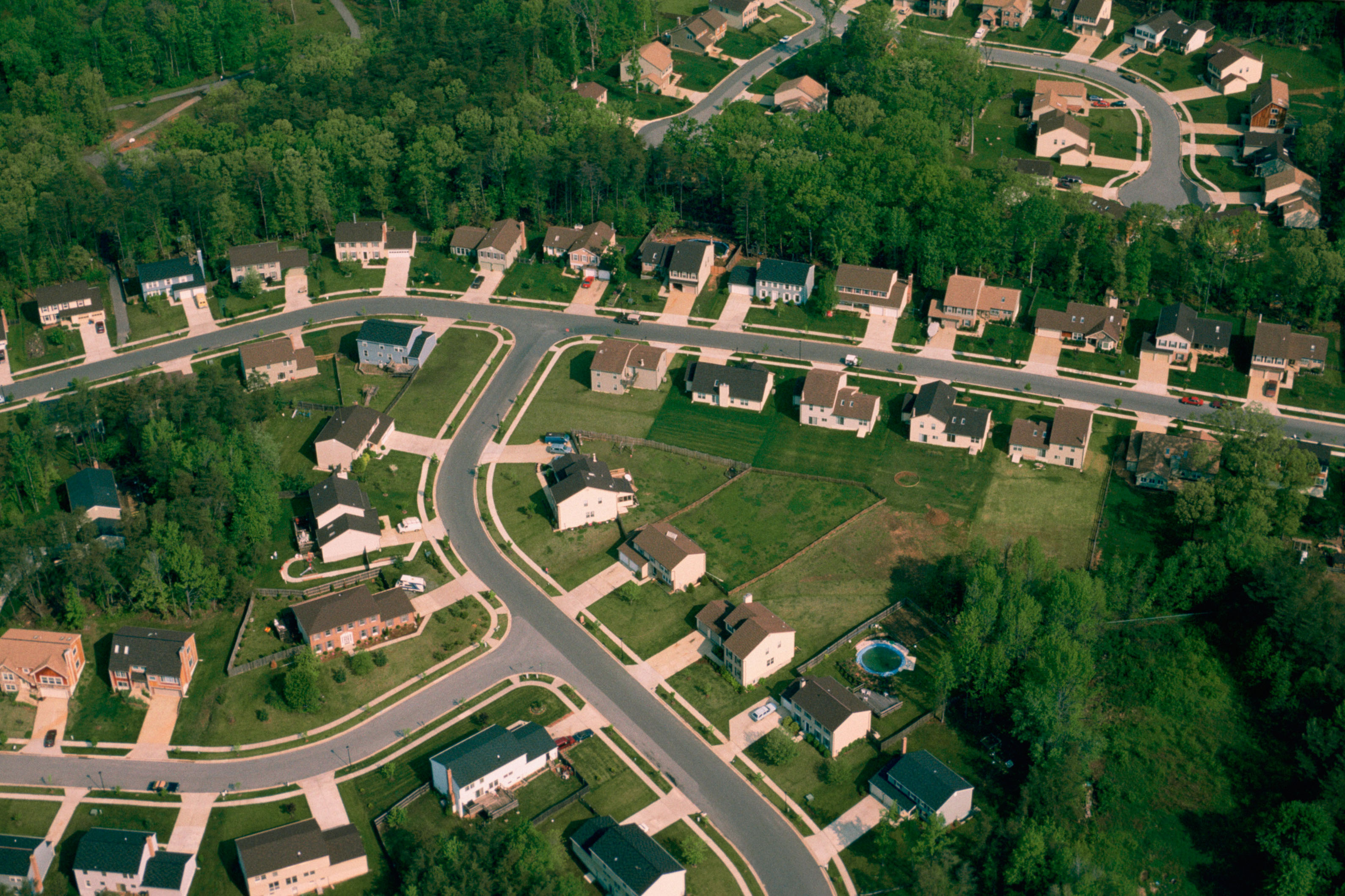
Washington’s suburbs include cities and towns as well as large open areas of hills, woods, and farms. However, increases in population and the spread of the suburbs has begun to threaten remaining open spaces. The suburbs are under the jurisdiction of the states or counties in which they are located.
In the Washington area, as in other metropolitan areas, large numbers of people who live in the suburbs work in the city. However, beginning in the mid-1900’s, a number of belt cities have sprouted around the Washington suburbs.
The first of the belt cities were Beltsville and Greenbelt in Maryland. These cities grew up around a major U.S. agricultural research center. In Virginia, substantial suburban centers later developed at Tysons Corner, around the high technology and telecommunications firms; around the Pentagon in Arlington; and around Washington Dulles International Airport in Loudoun County. Development also took place along the I-270 corridor in Montgomery County, Maryland, the site of the National Institutes of Health, Walter Reed National Military Medical Center Bethesda, and numerous biomedical research organizations. A number of federal agencies have moved to these suburban areas, fueling further growth.
Two of the most famous new towns in the United States—Columbia, Maryland and Reston, Virginia—are near Washington. Begun in the early 1960s, these two communities were carefully planned before they were built (see City planning (Building new communities)).
People
Population.
About 40 percent of the people of Washington, D.C., are African Americans. Non-Hispanic white people make up nearly 40 percent of the city’s population. Hispanic people, who may be of any race, account for about 10 percent of the population. Asian people and Indigenous (native) Americans together make up about 5 percent of the population.
The suburbs remain primarily white, though a number of African Americans moved to the suburbs in the late 1900’s. Also during the late 1900’s, many refugees from countries torn by war and political turmoil settled in Washington and its suburbs. They included many people of Southeast Asian and Hispanic origins. Some of these newcomers live close together, creating interesting ethnic neighborhoods. These residents as well as the staffs of the many embassies and international organizations help give Washington a cosmopolitan flavor.
Housing.
About 40 percent of Washington’s residents live in one- or two-family houses, and about 60 percent in apartments or condominiums. Approximately 40 percent own their homes. The lack of sufficient housing remains one of the most crucial problems facing the Washington area.
Education.
The majority of elementary and secondary students in the District of Columbia attend traditional public schools. The traditional public school system is directly governed by the mayor, who appoints a chancellor to administer the system. Thousands of students attend public charter schools, which operate under special contracts called charters that give the schools more freedom than traditional public schools. Charter schools are authorized and overseen by a mayor-appointed board. Both traditional public schools and charter schools are funded by local taxes. An official called the state superintendent of education, appointed by the mayor, sets policies and standards for all public education in the district. The state superintendent is advised by the D.C. State Board of Education, which consists of nine elected members. Thousands of students attend private schools in the city.
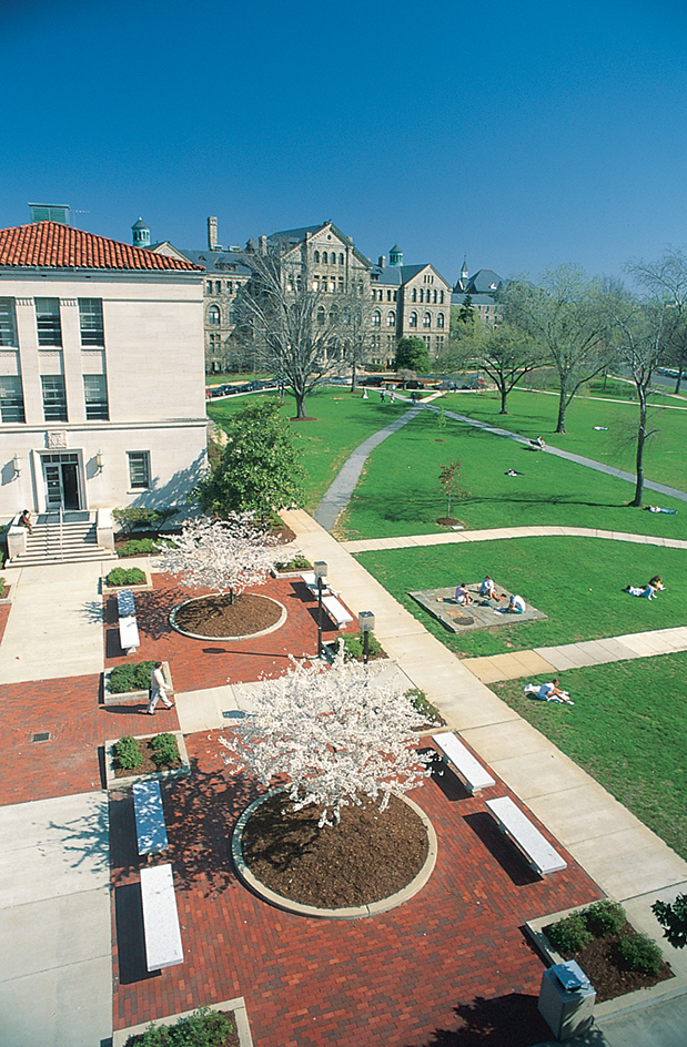
Washington’s many accredited colleges and universities include American, Catholic, Gallaudet, George Washington, Georgetown, and Howard universities, and the University of the District of Columbia. Howard University is one of the country’s largest predominantly Black colleges and has a long history of producing important African American leaders. The Catholic University of America is the national university of the Roman Catholic Church in the United States.
Washington does not have a comprehensive state university. Under legislation passed by Congress, high school graduates who are residents of the district are eligible to attend any state university in the United States and pay in-state tuition.
Social problems.
Like all major cities, Washington faces a variety of social problems, including poverty and crime. Due to rapid population growth, the area also struggles with the need for more housing, schools, highways, and Potomac River crossings.
Overall, the people of Washington have a high standard of living. However, thousands of people who live in the city and suburbs do not share in the wealth. Approximately 15 percent of all the families in the city and about 5 percent of the families in the suburbs have incomes that classify them as poor by U.S. government standards. Unemployment is low, but there are shortages of qualified workers in several sectors of the economy.
In the 2000’s, crime rates have generally risen in the suburbs while dropping in the city. Washington crime receives more nationwide publicity than that of most other cities because the federal government is located there.
Cultural life and recreation.
The museums, government buildings, parks, monuments, libraries, and theaters described in the Visitor’s guide help make Washington a leading cultural and recreational center. Residents as well as tourists enjoy these opportunities.
Washington also has many cultural and recreational facilities used chiefly by its residents. These include the public library system. The system’s main library is the Martin Luther King, Jr., Memorial Library at 9th and G Streets NW. The city has an increasing number of professional acting companies. Its main theaters include the Arena Stage, the Harman Center for the Arts, the National Theatre, Ford’s Theatre, and the John F. Kennedy Center for the Performing Arts. The National Symphony Orchestra, the Washington National Opera, the Washington Ballet, and touring companies of Broadway productions entertain audiences in the performance spaces at the Kennedy Center.
Washington has dozens of parks. Many Washingtonians enjoy boating on the Potomac River or in nearby Chesapeake Bay. Local sports teams include the Washington Nationals baseball team of the National League, the Washington Commanders of the National Football League, the Washington Wizards of the National Basketball Association, D.C. United of Major League Soccer, and the Washington Capitals of the National Hockey League.
Economy
Washington’s economy thrives on tourism and the activities of the federal government. The city’s many attractions, which include the largest concentration of museums in the world, draw millions of tourists each year. The federal government is the largest employer in Washington and its surrounding area. It also generates a substantial portion of Washington’s private economic activity. Since the late 1900’s, however, the local economy has diversified considerably. The city still depends primarily on service industries. But leading employers outside of government and tourism now include business, finance, and trade associations; health care; higher education; information technology and telecommunications; and the communications industry.
Government.
The federal government employs tens of thousands of people in Washington and many more in the surrounding metropolitan area. The best-known and most important government employees include the president of the United States, the president’s Cabinet officers and advisers, the members of Congress, and the Supreme Court justices. Those key policymakers account for only a tiny portion of Washington’s government workers, however. Most government employees staff the departments and agencies of the executive branch. They carry out the daily operations of the government, on which individual citizens depend.
Washington is one of the nation’s few cities with little manufacturing employment. The primary manufacturing industry in the city is printing and publishing, most of which is done by the federal government. Government printing makes Washington one of the nation’s leading publishing centers. Its departments and agencies produce pamphlets and books on thousands of subjects, ranging from census information to farming advice.
Other service industries.
The federal government remains the leading employer in Washington. It employs about a fifth of all workers. But many of the city’s people work in a variety of other service industries.
Many businesses and private organizations have offices in Washington so that they can closely observe and interact with the federal government. These organizations employ thousands of workers and include law firms; accounting, banking, and financial organizations; labor unions; and trade associations. Perhaps the best-known people in this category are lobbyists, people who work to influence the government on behalf of their members or clients.
Health care employs thousands of workers. Hospitals in Washington include Children’s National Hospital; St. Elizabeths Hospital, which provides care for people with mental illnesses; and a major Department of Veterans Affairs (VA) hospital. The city also has hospitals associated with medical schools at Howard, George Washington, and Georgetown universities. The presence of these medical schools and of the National Institutes of Health in Bethesda, Maryland, has attracted a large concentration of biomedical and genetic research organizations to Washington and the suburbs of Montgomery County, Maryland.
Tourism is important to Washington’s economy. The city hosts millions of tourists each year. They come to see the United States government in action. They also come to visit the many museums, historic sites, and monuments and to enjoy the city’s cultural activities. Hotels, motels, and restaurants employ thousands of people in Washington.
Higher education is an important part of the Washington economy. Tens of thousands of students from every U.S. state and most of the world’s countries are enrolled in the city’s colleges and universities.
Information technology and telecommunications firms employ thousands of people in Washington and make up an important part of the area’s economy. Telecommunications firms with headquarters in the Washington area have particularly influenced growth in the northern Virginia suburbs.
Communication.
The city has two daily newspapers, The Washington Post and The Washington Times, and a number of radio and television stations. All of the nation’s major television networks and metropolitan newspapers have Washington bureaus. In addition, newspeople from all over the world are stationed in Washington to provide first-hand accounts of events that will affect the lives of people in their countries.
USA Today, a national daily newspaper, is based in the suburb of McLean, Virginia. The United Press International wire service is headquartered in Washington. Many periodicals are published there, including National Geographic, the National Journal, and Smithsonian.
Transportation.
The Washington area has an extensive public transportation system. Many of the people who work in the metropolitan area use public transportation to get to and from work. The Washington Metropolitan Area Transit Authority, known as Metro, operates a bus service and a rail system that serve the city and its suburbs. The final part of the original 103-mile (166-kilometer) Metro system was completed in 2001. Later extensions have expanded the reach of the rail network. Commuter rail lines connect Washington with cities and towns in neighboring Maryland and Virginia.
Over half of the area’s workers use automobiles to get to and from their jobs. Washington is served by one of the country’s most extensive highway systems. The system includes six major interstate highways and a large network of roads and bridges. Increases in population, however, have put a severe strain on Washington roads and highways. Traffic congestion has become one of the most difficult problems facing the region.
Union Station, Washington’s railroad station, lies two blocks north of the U.S. Capitol. Amtrak provides passenger rail service from the station to all major cities on the East Coast and to many cities in the West. Union Station is the southernmost destination for the high-speed Amtrak trains that serve the Northeast. The station is the terminal for local commuter trains, and it has a Metro subway stop.
Three major airports handle Washington’s commercial air traffic. Ronald Reagan Washington National Airport lies just across the Potomac River in Arlington, Virginia. Washington Dulles International Airport, also in Virginia, is 25 miles (40 kilometers) west of Washington. The Reagan and Dulles airports have Metro subway stops. Baltimore-Washington International Thurgood Marshall Airport is in Maryland, about 30 miles (48 kilometers) northeast of Washington.
Local government
Washington’s system of local government is different from that of all other American cities. As in most cities, local citizens elect a mayor and city council to make laws and carry out government functions. However, the federal government has veto power and final authority in all matters relating to Washington.
Washington’s mayor serves a four-year term. The mayor appoints the heads of city agencies and departments.
The Council of the District of Columbia has 13 members. Five members are elected by the city as a whole. One member is elected from each of Washington’s eight wards. The members are elected to four-year terms. The council passes local laws, and the mayor may sign or veto their legislation. However, all city laws are subject to veto by the U.S. Congress. Congress and the U.S. Office of Management and Budget must approve the city’s budget each year.
Washington’s city government gets the majority of its revenue from taxes, including property, sales, and local income taxes. The federal government makes an annual payment to the city in lieu of property taxes on the land occupied by government offices.
Washington’s present system of local government was established by an act of Congress in 1973 and approved by the voters in 1974. For 100 years before that time, the people of Washington had almost no voice in their government. The president, rather than the people, chose the three commissioners who made up the government. See the History section of this article for details on Washington’s former system of local government.
History
Early days.
Historians believe that Indigenous people first lived in what is now the Washington, D.C., area about 12,000 years ago. Captain John Smith, the English soldier who helped establish the colony at Jamestown, Virginia, explored the Potomac River in 1608. At that time, he found a well-established settlement of Indigenous Nacotchtank people, a group that spoke the Algonquin language. The Nacotchtank initially welcomed English trade and alliances, but conflicts over property ownership led to bloody battles. The Nacotchtank then abandoned their villages and retreated into the forests.
By 1660, a few wealthy and powerful English colonists began to acquire land along the Potomac River for tobacco cultivation. They established large plantations that were worked by enslaved people forcibly transported from Africa. In 1740, a tobacco inspection station and warehouse were established on the Maryland side of the Potomac River. In 1751, the community that grew up around the inspection station was named George Town (later spelled Georgetown). By 1791, when it became part of the area chosen as the capital, Georgetown was one of the nation’s leading tobacco ports and trading centers.
Choosing the capital.
Several different cities served as the nation’s capital during the early years of American independence. In 1783, Congress decided that the country should have a permanent center of government. It was difficult for the members of Congress to agree on a location because they realized that the area where the capital was placed would gain wealth and political influence. Representatives from the Northern states wanted the capital to be in Philadelphia. Southerners felt that the economic interests of the Northern states were too different from their own, and they wanted the capital in a state where slavery was legal.
Alexander Hamilton and Thomas Jefferson worked out a compromise. Hamilton, who was serving as the U.S. secretary of the treasury, was concerned about stabilizing the national economy. He felt that Congress should agree to pay the debts that some Northern states still owed due to their participation in the American Revolution (1775-1783). Jefferson, the secretary of state, was from Virginia, a state that had already paid all its war debts. Jefferson agreed to support Hamilton’s proposal if Hamilton would agree to locating the capital in a Southern city. Their compromise resulted in Congress passing the Residence Act of 1790.
The act gave President George Washington the power to choose a spot for the capital. Washington selected an area of 100 square miles (259 square kilometers) on the Potomac River between the mouth of the Eastern Branch (now known as the Anacostia River) and Conocheague Creek, 70 miles (113 kilometers) upstream. The site Washington chose was only a few miles north of his home at Mount Vernon, Virginia.
The president’s choice, made in 1791, included the land north of the Potomac that is now occupied by the city as well as an area south of the Potomac River. The land north of the Potomac, which belonged to the state of Maryland, included the port of Georgetown. The land south of the Potomac, which belonged to Virginia, had a well-established tobacco port of its own, Alexandria. The states of Maryland and Virginia turned over the territory to the federal government.
Building the city.
George Washington hired Pierre Charles L’Enfant, a French engineer, to create a plan for the physical layout of the city. L’Enfant’s plan dealt only with the area between the Anacostia River and Georgetown, and extended north only to what is now Florida Avenue. Georgetown, Alexandria, and Washington County (the land north of Florida Avenue) remained separate, with their own local governments. The entire plan centered around the placement of the U.S. Capitol on Jenkins Hill, which L’Enfant called “a pedestal awaiting a monument.” L’Enfant’s plan is discussed in more detail earlier in this article, in the section The City.
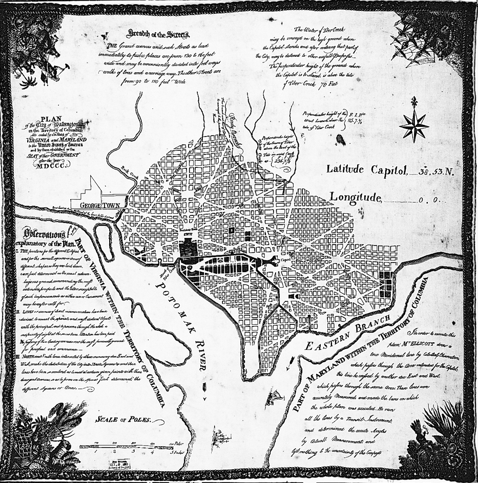
President Washington had to persuade the people who owned the land designated as the capital to donate their property to the U.S. government. Because L’Enfant had difficult relationships with the local landowners and government officials, Washington had to fire him before his work was completed. But two surveyors, Andrew Ellicott and Benjamin Banneker, laid out the streets and lots according to L’Enfant’s plan. Ellicott was a veteran of the Revolutionary War. Banneker was a free African American scientist and mathematician.
President Washington appointed three commissioners to direct the construction and affairs of the new capital city. When the federal government moved to its new home in 1800, the commissioners named the city Washington, after the president who had played such a key role in the city’s establishment. They called the entire area the District of Columbia.
Slow beginnings.
The Constitution of the United States gave Congress the power to govern Washington. In 1802, Congress established a local government. The City Council members were elected by local residents, but the mayor was appointed by the president. In 1820, the citizens of Washington were granted the right to elect their own mayor. But they were not permitted to vote for members of Congress or the president.
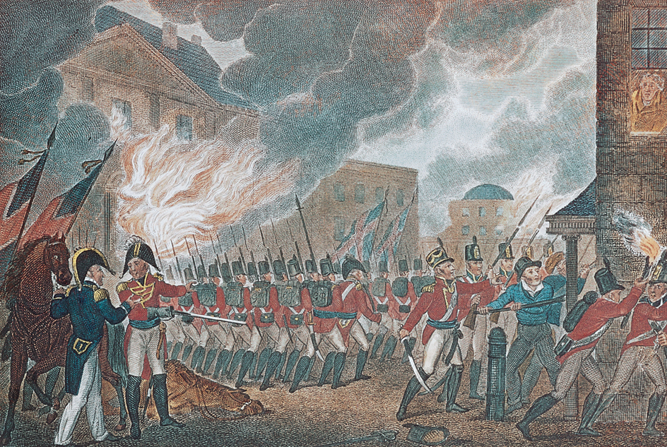
In August 1814, during the War of 1812, British soldiers invaded Washington and burned most of the public buildings, including the Capitol, White House, Library of Congress, and the Navy Yard. Members of Congress threatened to move the Capitol to a less vulnerable location, but Washingtonians persuaded them to stay. Workers completed the reconstruction of the government buildings in 1819.
The predictions that Washington would become an important commercial and industrial center did not come true right away. Once the Baltimore and Ohio Railroad was completed from Baltimore to Cumberland, Maryland, the city could no longer compete economically with Baltimore and other long-established cities, such as Boston, New York, Philadelphia, and Charleston. Lacking economic growth, Washington remained a small city. By the 1840’s, there were still only about 50,000 residents, and much of the land in the District of Columbia remained undeveloped. In 1846, Congress returned to Virginia the land south of the Potomac River.
The issue of slavery.
The presence of slavery in the capital of freedom remained a difficult issue and the subject of much argument. Enslaved Black people helped construct the U.S. Capitol, the White House, other federal buildings, and city streets. By 1830, free Black people outnumbered enslaved people in the District of Columbia. Washington’s City Council repeatedly tried to prohibit local slavery and the slave trade, but pro-slavery congressmen blocked their every attempt. In the mid-1800’s, Washington became the focus of the abolition movement. The underground railroad, an informal system that helped enslaved people escape, was active in both the city and Georgetown.
The Compromise of 1850 abolished the buying and selling of enslaved people in the District of Columbia. In 1862, several months before President Abraham Lincoln issued the Emancipation Proclamation, slavery was abolished there. The district conducted the nation’s only compensated emancipation. Slaveholders who were willing to swear a loyalty oath to the U.S. government were paid an average of $300 for each enslaved person.
The Civil War.
Washington’s main periods of growth have mostly been associated with times of crisis, such as wars and depressions. During such times, the role of the federal government has expanded to deal with the country’s problems, resulting in increased employment opportunities in the capital city.
The American Civil War (1861-1865) was the first crisis that caused Washington to expand. During the war, the city’s population nearly doubled, from about 60,000 to 120,000. The Union stationed thousands of troops in Washington to protect the city from Confederate attack. Large numbers of people flocked to the city to participate in the war effort. In addition, thousands of people escaping slavery, known as “contrabands,” poured into Washington from the South. Most of them settled near Union military camps. After Lincoln issued the Emancipation Proclamation, the number of Black refugees increased. The enormous population growth led to a severe housing shortage. Public facilities, such as water and sewerage systems, could not handle the increased demands.
Congress began a major rebuilding and expansion program in Washington after the war. The program solved the city’s physical needs. But it indirectly led to an end of the people’s right to choose their local government leaders.
Territorial government abolished.
In 1871, Congress established a territorial government for the district, headed by a governor appointed by the president. However, the territorial government was dominated by Alexander “Boss” Shepherd, the head of the Board of Public Works. Shepherd directed a massive program of construction and improvements that transformed Washington into a beautiful modern city. But Shepherd vastly overspent his budget, and he came under criticism for his procedures for awarding contracts. He was accused of favoritism and dishonesty.
In 1874, a congressional committee investigated the Board of Public Works and discovered that the territorial government was nearly $19 million in debt. In their dismay at what they saw as sloppy business practices, the members of Congress abolished the territorial government. They replaced it with a panel of three commissioners. The president appointed the commissioners, who had absolute control over district affairs.
Georgetown and Washington County lost their independent existence and became part of the city of Washington. Even the street names were changed in Georgetown to conform to the L’Enfant plan. Washington became the only American city in which the people did not elect their local officials.
Continued growth.
In 1917, when the United States entered World War I, another period of enormous growth began. Again, the government needed new workers to help direct the war effort as well as the businesses and services to support them. The city’s population increased from about 350,000 when the country entered the war to more than 450,000 in 1918, when the war ended. Shortages developed in housing, office space, and public facilities. The public school system was particularly hard-hit. Overcrowded classrooms held as many as 60 students. A number of new neighborhoods developed in what had previously been the farmland and countryside of Washington County.
During the Great Depression of the 1930’s, jobs became scarce in all parts of the country except Washington. The federal government undertook numerous projects designed to end the Depression, and thousands of new government jobs were created. Washington’s population grew from about 485,000 to 665,000 between 1930 and 1940. The participation of the United States in World War II accelerated Washington’s growth during the 1940’s. The district’s population peaked at more than 800,000 in 1950.
Population changes.
The city’s population began to decline during the 1950’s. However, the population of the surrounding suburbs increased. The city’s population decline began with school desegregation in 1954. At that time, many white families moved to the suburbs. Since about 1955, African Americans have made up the majority of the city’s population. However, since the 1970’s, many of the city’s African Americans have also moved to the suburbs.
Between 1950 and 1980, the population of the Washington metropolitan area grew faster than that of any other large city. It increased from about 1 1/2 million to more than 3 million. By 2020, the metropolitan population rose to nearly 6 1/2 million.
Government changes.
After World War II, many Washingtonians began demanding the right to participate in government. Congress and the states passed a constitutional amendment that allowed Washingtonians to vote in presidential elections for the first time in 1964.
In 1967, President Lyndon B. Johnson reorganized the district’s government by executive order. A mayor and nine-member City Council replaced the three-member board of commissioners. The mayor and council members were appointed by the president. Johnson named as mayor Walter E. Washington, a former District of Columbia housing administrator. Washington became the first African American to head a major U.S. city.
In 1970, Congress passed legislation permitting Washington to have a delegate in the U.S. House of Representatives for the first time since 1875. The delegate may vote in committees but not in votes of the full House of Representatives. Many Washingtonians feel this is unjust. They argue that they pay federal income taxes but have no voice in the legislative process that determines those taxes.
In 1973, Congress granted Washingtonians the right to elect local officials for the first time in 100 years. In 1974, city voters elected as mayor Walter E. Washington, who had held the post as an appointee since 1967. The mayor and the Council of the District of Columbia took responsibility for oversight of the city’s 14 local government departments.
In the 1970’s, many Washingtonians began to support a movement to make the District of Columbia a state. In a 1980 election, a majority of Washington’s voters supported statehood and, two years later, chose the name New Columbia for the proposed state. The statehood petition was sent to the U.S. Congress for approval in 1983. In 1992, the U.S. House of Representatives approved statehood, but the Senate declined to vote on the issue. Statehood bills were introduced in both houses of Congress in 1993, but neither passed. The U.S. House passed statehood bills in 2020 and 2021, but they never came to a vote in the Senate.
The city underwent a serious financial crisis in 1995. As a result, Congress seized control of the district government and created a Financial Control Board to run the city. The president appointed the members of the board. Control of some city functions was restored to local elected officials in 1999, and control of the rest was restored by 2001. The operations of the Financial Control Board created renewed local support for the movement to make the district a state.
The 2000’s.
On Sept. 11, 2001, terrorists crashed a hijacked commercial airplane into the Pentagon Building, near Washington, D.C. In related incidents that day, two more hijacked planes crashed into the twin 110-story towers of the World Trade Center in New York City, and a fourth hijacked plane crashed in Pennsylvania. Part of the Pentagon was destroyed and, in New York, both towers of the World Trade Center collapsed to the ground. About 3,000 people were killed. The terrorist attack was the worst in U.S. history. See September 11 terrorist attacks.
In 2008, the Nationals baseball team moved into a new stadium in southeast Washington near the Anacostia River.
In September 2013, a shooting took place at the Washington Navy Yard in the southeastern part of the city. A gunman killed 12 people and wounded several more before being shot and killed by police officers.
