Zambezi << zam BEE zee >> River is the fourth longest river in Africa. Only the Nile, Congo, and Niger rivers are longer. The Zambezi rises in Zambia, near the border between Angola and the Democratic Republic of the Congo. The river follows a winding 1,700-mile (2,736-kilometer) course, separating Zambia from Zimbabwe and crossing Mozambique to empty into the Mozambique Channel. The Zambezi has many branches and drains more than 500,000 square miles (1,300,000 square kilometers).
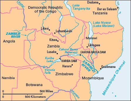
The upper course of the river lies in level land, where the water supply depends on equatorial rains that fall from October to March. From this plateau, the Zambezi plunges to a lower level over Victoria Falls, a mighty cataract of water. A hydroelectric plant has been in operation there since 1938. Kariba Dam, completed in 1959, lies in Kariba Gorge, about 200 miles (320 kilometers) downstream. It forms a lake that covers 2,000 square miles (5,200 square kilometers).
Early geographers knew of the Zambezi region, probably through Arab traders. The first European to explore the Zambezi River was David Livingstone. He explored the river in the 1850’s.
See also Stanley and Livingstone; Victoria Falls.
