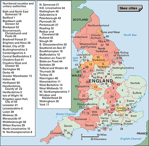
Cambridgeshire (pop. 678,849) is an inland county in eastern England. It is mainly flat and thinly wooded and crossed by a few slow rivers. The northern part of the county, consisting mainly of the Isle of Ely, is low-lying ground. Much of this northern area was formerly marshy land that has been drained and reclaimed. The county is best known for its productive agriculture, its high-technology industries, and the great educational city of Cambridge. See Cambridge, University of.

Cambridgeshire was enlarged in 1965, when it was combined with the Isle of Ely. Cambridgeshire was further enlarged in 1974, when it took over the county of Huntingdon and Peterborough. This last change was part of a general reorganization of the local government of England and Wales. In 1998, Peterborough became a unitary authority, with all local government powers within its boundaries (see Peterborough).
People and local government
Local customs.
St. Ives has a unique custom, dicing for Bibles, which dates from the 1600’s. At that time, a sum of money was left to provide Bibles for poor children. Each year, on Whit Tuesday, six children from the Church of England and six from the Free Churches throw dice. The six winners each receive a Bible.
Recreation.
The University of Cambridge cricket team plays some first-class matches and has its own ground. Cambridge also has a professional soccer team. Hunting and riding are popular. Cambridgeshire’s rivers are ideal for boating and fishing. Sailing has become an important sport on Grafham Water.
Local government.
Cambridgeshire is divided into five districts for administration: Cambridge; East Cambridgeshire, which includes Ely; Fenland, which includes March and Wisbech; Huntingdonshire, which includes St. Neots; and South Cambridgeshire. The county council provides some public services throughout the county.
Cambridgeshire is policed by the Cambridgeshire Constabulary, with headquarters at Huntingdon. The crown court meets at Cambridge and Huntingdon.
Economy
Agriculture
is the main industry in Cambridgeshire. Farmers grow barley and wheat, onions, potatoes, soft fruit, and sugar beet. Flower bulbs grow in vast numbers in the Wisbech area. Farm animals include beef and dairy cattle, pigs, poultry, and sheep.
Manufacturing and quarrying.
Much of the county’s manufacturing industry is linked with agriculture. Wisbech has large food-freezing and canning industries. Factories at Ely and Peterborough extract sugar from beet. Histon is a centre for jam making. Brewing is a widespread industry, using local barley. In Huntingdon, several new light industries have developed, in addition to its traditional agricultural engineering. Many high-technology factories at Cambridge produce electronic goods and scientific instruments. A factory at St. Ives produces electronic calculators.
Mining in Cambridgeshire produces clay for the local brick industry and chalk for cement works. Mining in the Ouse valley also produces some gravel.
Transportation and communication.
Several important roads cross Cambridgeshire. They include the Great North Road (A1), leading north from London; the A11, from London to Norwich; and the A14 and A45, which link the Midlands to the east coast ports. The M11 links Cambridge with London.
A railroad from London to the north passes through Huntingdon. Another railroad links Ely and Cambridge with London. March has one of Europe’s largest railroad freight marshalling yards.
Wisbech is an inland port. It has regular sea connections with the European mainland. Air services in the summer link Cambridge Airport with the Channel Islands and continental Europe. Cambridgeshire has a number of local newspapers and radio and television stations.
Tourism.
Many tourists visit Cambridge to see the beautiful university buildings. The county has many hotels, particularly in the Cambridge area.
Land and climate
Location and size.
Cambridgeshire borders on Lincolnshire and the unitary authority of Peterborough to the north; Norfolk and Suffolk to the east; Hertfordshire and Essex to the south; and Northamptonshire and the unitary authorities of Bedford and Central Bedfordshire to the west.
Cambridgeshire measures about 37 miles (60 kilometers) from east to west at its widest and 50 miles (80 kilometers) from north to south.
Land features.
Almost the whole of Cambridgeshire is flat. The northern parts of the county are fenlands. The county’s only hills are in the southeast. The Gog-Magog Hills rise to a maximum height of only 295 feet (90 meters) above sea level.
Rivers and lakes.
The Great Ouse flows across the county from southwest to northeast. Its main tributaries are the Cam, the Little Ouse, and the Kym rivers. The River Cam starts where three rivers come together south of Cambridge. These rivers are the Rhee (also called the Upper Cam), the Granta, and the Bourne.
Portholme Meadow, beside the River Ouse at Huntingdon, is a water meadow, kept fertile by flooding of the river. It is one of England’s largest and most beautiful water meadows.
Climate.
Cambridgeshire is one of England’s coolest counties, and also one of the driest. Winter temperatures average about 37 °F (3 °C) and summer temperatures about 63 °F (17 °C). Average annual rainfall is about 211/2 inches (545 millimeters).
History
An Iron Age people, the Iceni, lived in Cambridgeshire. The Romans defeated the Iceni in A.D. 60. Later, the Saxon kingdom of Mercia covered most of what is now southern Cambridgeshire. The Normans built a castle at Huntingdon. The University of Cambridge, often called Cambridge University, was probably founded in 1209. In the 1600’s, a Dutch engineer, Cornelius Vermuyden, drained some of the fens for use as farmland. Oliver Cromwell was born in Huntingdon in 1599. Economist John Maynard Keynes and actor Richard Attenborough were born in Cambridge.
