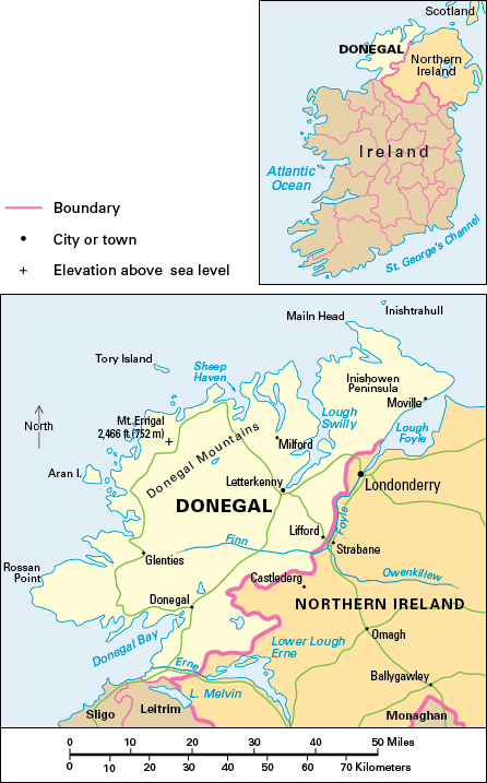
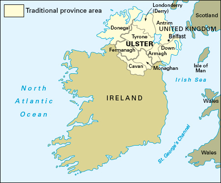
Donegal, County, is part of the Republic of Ireland. It lies on the northwest coast of the island of Ireland. It is one of the three counties—with Cavan and Monaghan—of the province of Ulster that are not in Northern Ireland. Only a narrow strip of land connects County Donegal with the rest of the Republic of Ireland, making it more isolated than any other county in the nation. In Irish, County Donegal is called Contae Dún na nGall.

County Donegal has an area of 1,865 square miles (4,830 square kilometers). It is well known for its beautiful scenery and its tweed cloth. Letterkenny is the largest town. The Gaeltacht, the part of Ireland where people use the Irish language in everyday life, covers a wide area in western County Donegal.

Most of the county’s workers are employed in service industries, which include education, food services and hotels, health care and social work, and retail and wholesale trade. Tourism is a major industry throughout County Donegal and especially in coastal areas. People enjoy the county’s excellent beaches and its beautiful coastal and mountain scenery.
The manufacturing, construction, and agriculture sectors are also important employers. For a long time, manufacturing has been more important in County Donegal than in most other parts of the Republic of Ireland. County Donegal is famous for handmade tweed and knitwear. Other industries in the county include the processing of fish and other food, and the manufacture of health care products and telecommunications equipment. The main type of farming is the raising of cattle. Some farmers are involved in dairying and the raising of hogs and poultry. The chief crops are barley, oats, and potatoes. Fishing is also important in the county.
Many monuments in County Donegal date from Stone Age times. The ancient name of the kingdom that occupied much of present County Donegal during the Middle Ages was Tír Chonaill (spelled Tyrconnell in English), meaning land of Conall. Conall was the name of the Irish king who, according to legend, ruled the area during the A.D. 400’s. The descendants of Conall became the O’Donnells. Inishowen and Tyrone belonged to the O’Neills, who were descended from Eoghan, thought to be the brother of Conall. Rivalry between the O’Donnells and the O’Neills dominated the history of northwestern Ireland for 1,000 years. The O’Donnells’ headquarters were in Grianan of Aileach, an impressive stone fort between the River Foyle and the inlet called Lough Swilly.
The Anglo-Normans never gained control of what is now County Donegal. In 1585, the British government organized the area into a county based on the town of Donegal. The Irish chiefs Red Hugh O’Donnell and Hugh O’Neill united to fight the British at the Battle of Kinsale in 1601 but were decisively defeated. They surrendered to the British in 1603.
See also Gaeltacht; Ireland; Tory Island; Ulster.
