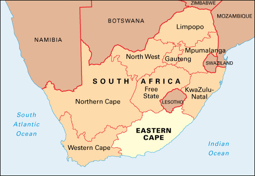
Eastern Cape is a province in the southeastern part of South Africa, on the coast of the Indian Ocean. At 65,238 square miles (168,966 square kilometers), Eastern Cape is South Africa’s second largest province in area. Only Northern Cape is larger. The capital of Eastern Cape is Bisho. Nelson Mandela Bay (Port Elizabeth) is the province’s largest municipality. A municipality may include rural areas as well as the urban center. The most widely used language in Eastern Cape is Xhosa (isiXhosa). Other languages spoken in the province include Afrikaans, English, and Sesotho.

The province of Eastern Cape was established in 1994. It includes parts of the former Cape Province and the former Black African homelands of the Transkei and Ciskei.
Economy.
Much of Eastern Cape’s land is used for agriculture. The province’s main crops include chicory, corn, fruit, potatoes, tobacco, and wheat. Farmers raise dairy and beef cattle, as well as sheep. Fishing is a minor industry. Rural poverty and unemployment are widespread in Eastern Cape. Thousands of people in the province struggle to survive by subsistence farming, producing goods mainly for themselves, rather than for sale. The province is home to hundreds of thousands of migrant workers.
Eastern Cape has a thriving automotive industry and a growing tourist industry. Port Elizabeth is its leading industrial city. Scenic locations, such as the Garden Route, the Tsitsikamma National Park, and the Wild Coast, are popular tourist destinations. The province is well-served by road and rail links. Major ports include Port Elizabeth and East London.
Land.
Eastern Cape’s coastal area borders the Indian Ocean and extends for 500 miles (800 kilometers). It includes part of the Garden Route in the south and the Wild Coast in the north. The land rises gradually from the coast to the interior, where several mountain ranges run almost parallel to one another. Little Karoo and Great Karoo, two semidesert regions, lie between the ranges in the southern part of the province. The Drakensberg mountain range extends into the northeastern part of the province. There, Avoca Peak rises to 9,085 feet (2,769 meters).
Most of Eastern Cape’s main rivers drain the interior and flow southward toward the sea. The Orange River runs along the northern edge of the province. One of South Africa’s largest dams, the Gariep Dam, stands on the Orange River. Dams are used to store water for irrigation and for livestock.
History.
The first inhabitants of what is now Eastern Cape were hunter-gatherers. About 2,000 years ago, Khoikhoi herders moved into the western part of the region. In about A.D. 700, Southern Nguni farmers began settling in the area east of the Great Kei River, which later became known as the Transkei. By the 1600’s, these farmers were grouped into a number of chiefdoms. During the 1820’s, the Mfengu and the Bhaca came to the region after fleeing the increasingly powerful Zulu kingdom in the north.
In 1652, European settlers to the west founded the Cape Colony at the present site of Cape Town. Beginning in the late 1770’s, the Southern Nguni fought a series of wars with eastward-advancing Europeans. Dutch and British officials established boundaries to keep the African people of the east separate from the white settlers. The first colonial boundary was established along the Great Fish River in 1778. In the 1800’s, however, white settlers moved past the boundaries. Trade and Christianity spread, and urban centers developed at Port Elizabeth, Grahamstown, and East London. An area of land west of the Great Kei was ruled directly by the British high commissioner from 1847 until 1866, when it was included in the Cape Colony.
The British annexed territory from the Xhosa, a Southern Nguni group, in a series of wars. Starting in 1857, many Xhosa found work on the farms of white settlers, who came to control increasing amounts of land. In 1877 and 1878, the Cape government fought a war with the Xhosa east of the Great Kei, and the Cape Colony soon took control of territory there. The last remaining African independent state in the region, Pondoland, became part of the Cape Colony in 1894.
In 1910, the region became part of the Cape Province of the new Union of South Africa. The Transkei and parts of the Ciskei area to the west were ruled as native reserves, where individual landownership was not permitted. As the population of the reserves increased, so did their poverty, and almost all males were forced to work as migrants. The white government suppressed African resistance.
In the 1950’s and 1960’s, the Transkei took steps toward self-government as the first of the homelands, or bantustans, for Black Africans. The South African government set up the homelands as designated areas for racial groups during the period of apartheid (strict racial segregation). In 1976, the Transkei was granted nominal independence. Ciskei became independent in 1981. However, both territories remained poor and dependent on South Africa.
Violence escalated in the mid-1980’s, as resistance to apartheid and the homeland policy grew. Military regimes eventually ousted corrupt government administrations in the Transkei and Ciskei. In late 1989, the leader of the Transkei, Major General Bantu Holomisa, switched his support to the African National Congress (ANC), a political party that supported the rights of Black South Africans. In early 1994, Ciskei’s leader, Brigadier Oupa Gqozo, resigned.
In the early 1990’s, South Africa repealed the last of its apartheid laws. In 1994, both the Transkei and Ciskei became part of the new South African province of Eastern Cape. Bisho became the provincial capital. The ANC dominated the province’s politics into the early 2000’s. Eastern Cape has remained South Africa’s poorest province, though a large port was developed at Coega, near Port Elizabeth, to attract new industry.
