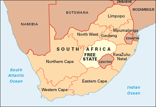
Free State is a province in central South Africa. It shares a border with the country of Lesotho and with all of South Africa’s other provinces except Limpopo and Western Cape. Free State lies between two of South Africa’s main rivers, the Vaal in the north and the Orange in the south. The province covers an area of 50,126 square miles (129,825 square kilometers). Bloemfontein is Free State’s capital. The city is home to the country’s Supreme Court of Appeal. The main languages spoken in Free State include Sesotho, Afrikaans, and Xhosa (isiXhosa).

Free State includes the former Black African homeland of Qwaqwa and part of the former homeland of Bophuthatswana. The South African government set up homelands as designated areas for racial groups during the period of apartheid (strict racial segregation). Apartheid lasted from 1948 until the early 1990’s.
Free State was founded as the Orange Free State, a free republic, in 1854. The name referred to the House of Orange, the Dutch royal family. In 1910, the state became part of the Union of South Africa. The Union of South Africa became a republic in 1961. In 1994, Free State became one of South Africa’s nine provinces.
Economy.
The chief sectors of Free State’s economy are mining and agriculture. Free State’s gold fields, centered on Welkom, were once the largest gold-producing areas in the world. Coal, diamonds, limestone, silver, and uranium are also mined in the province.
Because more than 90 percent of the province’s land is used as farmland, Free State has been called the “food basket” of South Africa. Free State is South Africa’s main producer of wheat and a major corn grower. Other crops grown in Free State include alfalfa, barley, beans, oats, peas, peanuts, potatoes, sorghum, and sunflowers. Farmers raise sheep for wool and meat and also keep cattle.
Because of its central location, Free State is a crossing point for national roads and rail networks. Sasolburg has a major chemical manufacturing and oil refinery plant. Free State has several dams that are important for irrigation, the production of hydroelectric power, and the supply of water to the province of Gauteng. The Golden Gate Highlands National Park in the east of the province is a popular tourist attraction.
Land.
Free State is part of the Highveld, in the interior Plateau region of South Africa. It is an area of level plains with gently sloping highlands marked by scattered ridges. The western half of Free State lies 3,300 to 4,900 feet (1,000 to 1,500 meters) above sea level. The eastern half is higher, reaching altitudes of from 4,900 to 6,600 feet (1,500 to 2,000 meters). The eastern half borders the Drakensberg mountain range. The Rooiberg Mountains and Golden Gate area in the northeast are the highest parts of the province. Ribbokkop, one of the highest peaks, rises to 9,320 feet (2,840 meters).
The Vaal River, along with several tributaries, flows westward and drains the northern part of the province. The Orange and its tributaries also flow westward, draining the south. Many rivers in the province are nonperennial—that is, they do not last the whole year. The western parts of the province have numerous pans (natural depressions).
History.
People have lived in what is now Free State for thousands of years. The earliest known inhabitants of the region were Khoisan hunter-gatherers. Sesotho-speaking farmers moved south of the Vaal River around 500 A.D.
During the 1820’s, the region was disrupted by groups fleeing the rise of the Zulu kingdom to the east, and also by white colonial expansion from the west. Sesotho speakers took refuge with Moshoeshoe, a king based in what is now Lesotho, whose subjects lived near present-day Bloemfontein. White Boers (farmers) began to enter the region from the south. Boer pioneers known as voortrekkers followed in the 1830’s. After the British annexed Natal (now the South African province of KwaZulu-Natal), many voortrekkers in that area retreated into the northern part of what is now Free State.
In 1848, the British high commissioner annexed the area between the Orange and Vaal rivers and called it the Orange River Sovereignty. In 1854, however, the British government gave up its rule of the area because of the cost of governing it. That year, Boers established the Orange Free State (OFS) in the region.
In 1868, the British agreed with the Boers to establish the region’s eastern border at the Caledon River. In 1871, the Orange Free State lost its claim to the diamond fields found in the area, and they came under British control. By the early 1900’s, the OFS was mostly devoted to agricultural production and sheep farming.
During the late 1800’s, the OFS had close links with the Boers of the neighboring Transvaal region, who had been in conflict with the United Kingdom. From 1899 to 1902, the OFS was engaged in the second Anglo-Boer War (also called the Boer War or South African War). During the war, many farms were destroyed and large numbers of women and children died in British concentration camps. After the United Kingdom won the war, the OFS became a British colony called the Orange River Colony.
In 1907, the British gave the colony self-government. It became known the Orange Free State once again in 1910, when it entered the Union of South Africa, a self-governing country within the British Empire. The first conference of the South African Native National Congress (later the African National Congress or ANC) was held in Bloemfontein in 1912. Since its founding, the ANC has pushed for political and civil rights for Black South Africans.
In the early 1990’s, South Africa repealed the last of its apartheid laws. In South Africa’s first multiracial democratic elections in 1994, the ANC won a large majority. That year, the Black African homeland of Qwaqwa and part of the homeland of Bophuthatswana became part of the OFS. In 1995, the provincial legislature decided to drop the word Orange from the name of the province.
