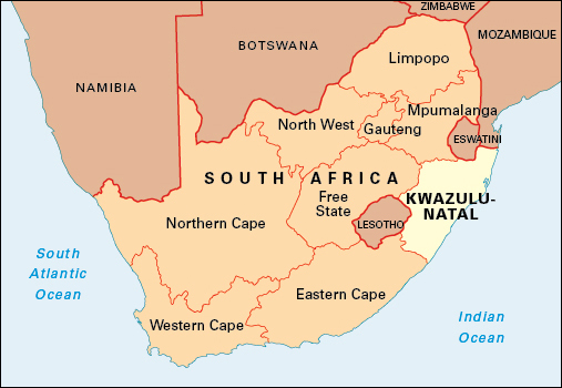
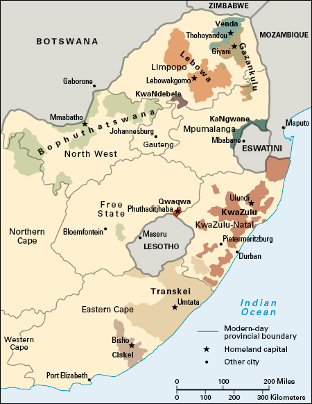
KwaZulu-Natal is the second largest of South Africa’s nine provinces in population. Only Gauteng has more people. KwaZulu-Natal came into existence on April 27, 1994. The province lies on South Africa’s eastern coast and shares country borders with Eswatini and Mozambique to the north, and Lesotho to the west. It shares provincial borders with Mpumalanga, Free State, and Eastern Cape. The province includes the former province of Natal and the former Black African homeland of KwaZulu.

KwaZulu-Natal covers an area of 36,433 square miles (94,361 square kilometers). Durban is the largest municipality in the province and one of the largest municipalities in South Africa. A municipality may include rural areas as well as the urban center. Pietermaritzburg is the capital of KwaZulu-Natal. Most people in the province speak Zulu (isiZulu). The other main language is English.
Economy.
KwaZulu-Natal produces and exports large amounts of sugar. Other chief agricultural products include cattle, corn, cotton, fruit, poultry, tobacco, and vegetables. Fishing and forestry are also important. The Durban region is the center of the province’s manufacturing industry. Major manufactured products include cars, chemicals, clothing, fertilizers, iron and steel, paper and pulp, processed foods, and rayon.
KwaZulu-Natal has rich reserves of coal. Other minerals mined in the province are chromium, copper, iron ore, nickel, and titanium. Most minerals are exported through the port of Richards Bay.
Durban’s pleasant climate and beaches attract many tourists. The area is one of South Africa’s main vacation destinations. In addition, Durban’s port is the busiest in South Africa. Most imports and exports to and from the province of Gauteng go through Durban.
Land.
KwaZulu-Natal has a long coastline bordering the Indian Ocean. From the low-lying coastal strip, the land rises 4,300 feet (1,300 meters) to the rolling hills and deep valleys of a region called the Midlands. East of the Midlands, the land rises to the Drakensberg mountain range.
Most rivers flow eastward to the Indian Ocean. The main rivers include the Mgeni and the Tugela. The Pongola River flows northward into Mozambique. The 312-foot (95-meter) Howick Falls are on the Mgeni River. Lake St. Lucia and Lake Sibaya are freshwater lagoons near the coast. The province’s game reserves include Drakensberg, Hluhluwe-Umfolozi, and St. Lucia.
History.
Nguni-speaking farmers probably entered the area in about 300 A.D. Small chiefdoms coexisted relatively peacefully until the late 1700’s, when two large confederations, the Mthethwa and the Ndwandwe, were formed. Shaka, chief of the Zulu, emerged to prominence in the Mthethwa. In about 1817, Shaka took over as the most powerful chief in the region and created a large kingdom, which soon covered much of what is today the province of KwaZulu-Natal.
In 1824, Shaka gave land at Port Natal (present-day Durban) to a small group of European settlers. Emigrant Boers (Dutch farmers) arrived overland in 1837 under Piet Retief. Retief’s party was massacred in early 1838. After the Battle of Blood River later that year, the Boers asserted their dominance over what became Natal, leaving Shaka’s successor to rule north of the Tugela River. The Boer Republic of Natalia, established in 1840, came to an end with British annexation in 1843, and shortly after that, the remaining Boers left the area. British immigrants helped give Natal a British character. In 1856, Natal gained its own Legislative Assembly.
In the 1860’s, large numbers of Indian indentured laborers began arriving to work in the sugar fields. By the 1890’s, there was a sizable Indian community in Durban and elsewhere.
By the 1870’s, the British viewed the independent Zulu kingdom north of the Tugela as a threat, and in 1879, Zululand was invaded by British and colonial troops. The British suffered a setback at the battle of Isandhlwana in January 1879. But after the defeat of Cetshwayo, the Zulu king, later that year, Zululand was divided into 13 kingdoms. In 1887, it was annexed by the British, and it was incorporated into Natal 10 years later. In 1910, Natal became a province in the new Union of South Africa. Some of Zululand came under white control and was used for sugar plantations, but most of it became a reserve and then, in the 1970’s, a bantustan (Black African homeland).
Mangosuthu Buthelezi became the leading figure in KwaZulu, and in 1975, he revived Inkatha, a Zulu cultural movement. He refused to accept independence on the government’s terms for his poverty-stricken bantustan.
From about 1987, conflict erupted between supporters of Inkatha, who were often aided by the security forces, and supporters of the African National Congress (ANC), many of whom were Xhosa. The Inkatha Freedom Party (IFP), launched under Buthelezi in 1990, tried to win greater autonomy for the province in South Africa’s new democracy, and then withdrew from the negotiations in protest.

A week before the first multiracial democratic election was to take place in April 1994, Buthelezi agreed that the IFP would participate in the election. As the electorate went to the polls, the fragmented KwaZulu bantustan was joined with Natal to form the new province. Despite allegations of fraud, the IFP claimed victory in the province, and Frank Mdlalose of the IFP became the first premier of KwaZulu-Natal, with Buthelezi the minister of home affairs in the Government of National Unity. Tensions between the IFP and the ANC remained high. The IFP gradually lost support, and in 2004 it lost control of the province to the ANC.
