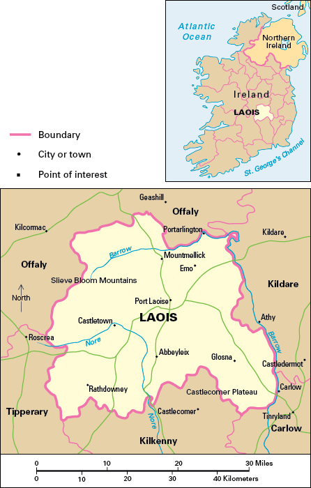
Laois, County, is a landlocked rural county in the province of Leinster in the Republic of Ireland. It forms part of the central lowland of Ireland. The name Laois is sometimes spelled Laoighis or Leix. The largest town and main service center is Port Laoise, sometimes spelled Portlaoise.

County Laois covers an area of 664 square miles (1,719 square kilometers). Most of the county’s people are Roman Catholics. Farms in the county produce a variety of crops, including barley, potatoes, sugar beets, turnips, and wheat. Grassland areas are used mainly for beef cattle production. There is also dairy farming, and pig and poultry production. Some farmers rear sheep. Retail and wholesale distribution are important activities in the service industry. Other services include catering, education, health care, public administration, and transport.
Food processing and general engineering are the chief manufacturing industries in County Laois. Ireland’s first peat-burning electricity generating station operated at Portarlington from 1950 until its closure in 1988. For many years, a factory processed peat moss near Port Laoise. Mining for anthracite coal was an important economic activity in the area until the late 1900’s. The county has some stone quarrying and stone cutting, and forestry remains important.
Most of County Laois is an undulating lowland made of limestone, drained by the rivers Nore and Barrow. There are peat bogs in some areas with poor natural drainage. The larger part of the Slieve Bloom Mountains lies in the western part of the county. The mountains consist of sandstone, slate, and shale, and rise to over 1,600 feet (500 meters). The River Barrow rises there and flows along the eastern boundary of the county. The Castlecomer plateau in the southeastern part of County Laois consists of shale and sandstone and rises to over 1,000 feet (300 meters).
The area now occupied by County Laois was once part of the ancient Irish kingdom of Ossory. The O’Mores were the main family in control of the territory. The rule of the O’Mores was interrupted temporarily by the arrival of the Anglo-Normans in the late 1100’s. English control finally came with the Tudor plantation of the 1500’s, when English colonists settled in the county. County Laois was named Queen’s County after Queen Mary Tudor. The chief towns date only from that period and later. Portarlington had many Huguenot settlers, and Mountmellick was a Quaker settlement. Abbeyleix was a town associated with the adjacent great mansion of Abbeyleix House, built in the 1700’s. During the Great Irish Famine in the 1840’s, more than a quarter of the population of County Laois died or emigrated.
