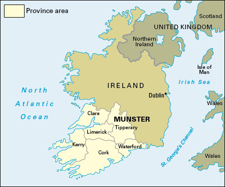
Munster is the largest of Ireland’s four provinces. It is in the south of the Republic of Ireland. It covers 9,315 square miles (24,125 square kilometers)—over one-third of the area of the country. It consists of six counties: Clare, Cork, Kerry, Limerick, Tipperary, and Waterford. Munster is the major dairy farming region of the Irish Republic, but also has three of the five largest cities: Cork, Limerick, and Waterford.

Most of the people of Munster are Roman Catholics. Many others are members of the Church of Ireland or have no religious affiliation.
The everyday language of most of Munster’s people is English. There are four main Gaeltacht areas—that is, Irish-speaking communities. They are in parts of counties Cork, Kerry, and Waterford.
Agriculture is an important feature of the economy throughout Munster. Dairying and hog production are the leading farm activities, particularly in Limerick. Beef cattle are also important. The eastern region is the main crop-growing area. The chief crops are barley, oats, potatoes, sugar beets, and wheat. The main industrial centers are in the Cork and Limerick-Shannon areas. Fishing is most important along Munster’s southwest coast.
For many years, counties Tipperary and Kerry were principal areas of Irish peat production. The peat was used in horticulture, or was burned for cooking fires or to provide electricity. Scientists came to understand that peat bogs play an important role in storing carbon that could contribute to climate change. Growing recognition of the bogs’ value led to the closure of Munster’s peat extraction facilities by the 2010’s.
Tourism is a major source of income, especially in Killarney and other parts of County Kerry. Other successful tourist areas are the western part of County Cork, County Limerick, the Golden Vale of Tipperary, and County Waterford. The city of Waterford, an important port, is most famous for its production of beautiful glassware. It also has electrical-engineering, food-processing, and paper and packaging industries.
The Atlantic Ocean forms the western and southern border of Munster. To the east is the province of Leinster, and Connacht is to the north.
Much of the landscape of Munster is a mixture of lowland and upland. The mountains are most extensive and highest in County Kerry and the western part of County Cork. Carrauntoohil, Ireland’s highest peak, rises 3,414 feet (1,041 meters) in the Macgillycuddy’s Reeks.
The main lowland districts are in the valleys of the major rivers. These are the lower part of the River Shannon and its tributaries in the north, and the Suir, Blackwater, Lee, and Bandon. The largest lake is Lough Derg on the Shannon, but the most famous lakes are the Lakes of Killarney.
Munster was one of the five kingdoms of Ireland nearly 2,000 years ago. The Rock of Cashel became the seat of the kings of Munster. Within the province there were two territories—Desmond in the south and Thomond in the north.
The British granted lands to settlers in the 1500’s and the 1600’s. In 1601, the British defeated most of the remaining Irish chiefs at the Battle of Kinsale. During the Great Irish Famine of the 1840’s, almost a fourth of Munster’s population died or emigrated.
