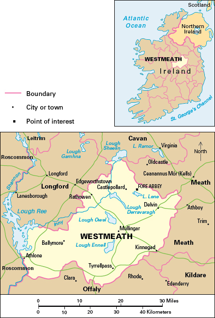
Westmeath, County, is a landlocked county in the province of Leinster in the Republic of Ireland. It lies in the northern part of the Irish central lowland and covers an area of 681 square miles (1,763 square kilometers). County Westmeath has many lakes and some bogland. Much of the county is rural.

Athlone and Mullingar are the county’s largest towns, each with about 23,000 people. Athlone lies on the River Shannon at the western edge of the county. It is a service center for the Irish midlands and has a regional technical college. Mullingar, to the northeast, is the county town (administrative center) and is an important market town.
Most of the people of County Westmeath are Roman Catholics. Most of the rest belong to the Church of Ireland or claim no religious affiliation.
Economy.
Beef cattle are the major farm product. There is a considerable trade in cattle to and from other areas. The main crops grown on the small amount of land that can be farmed include barley for cattle feed, potatoes, and wheat. Some farmers raise dairy cattle or sheep.
Light engineering and metal-products industries are by far the most important manufacturing industries. Industrial products include chemicals, clothing and textiles, electrical cables, electronics, processed foods, furniture and timber products, medical supplies, and plastic and rubber goods. Most of the manufacturing takes place in Athlone and Mullingar.
Wholesale and retail trade is the most important service industry. Other service industries include catering, defense, education, finance, health care, and tourism. Tourism is based on fishing, and on boating on the River Shannon.
Land.
County Westmeath borders County Meath to the east, County Offaly to the south, County Roscommon to the west, County Longford to the northwest, and County Cavan to the north. The surface of County Westmeath is a rolling lowland that lies on top of limestone. In the south are gravel ridges called eskers. Through the center of the county runs a line of lakes, including loughs (lakes) Ennell, Owel, and Derravaragh. The rivers Inny and Brosna drain much of the county toward Lough Ree and the River Shannon, which form the county’s western boundary.
History.
Stone Age remains on lake shores show that people have lived in what is now County Westmeath for over 6,000 years. The hill of Uisneach, west of Mullingar, was a sacred assembly place where the five provinces of ancient Ireland met. Much of the present-day county was the Gaelic territory of Teffia, within the ancient kingdom of Meath. Fore, near Castlepollard, was an important Celtic and medieval monastic site.
The area was granted to Hugh de Lacy after the Anglo-Norman conquest in the 1100’s. Mullingar and Athlone were established as towns during this period. Much of the area was under Irish control until the 1500’s. British settlers arrived in the 1600’s and later built some fine mansions. Throughout history, Athlone has had strategic importance as a crossing point on the Shannon. The town was in many conflicts, notably the siege of Athlone in 1691. At the time of the Great Irish Famine of the 1840’s, one-fifth of County Westmeath’s population died or emigrated.
