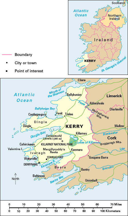
Kerry, County, lies along the southwestern coast of the Republic of Ireland. It is one of the counties in the province of Munster. County Kerry is famous for its scenery. The Lakes of Killarney, which draw many tourists to County Kerry, are among Ireland’s most famous scenic areas. Agricultural lowland in northern County Kerry contrasts with the mountainous south and west of the county. County Kerry covers an area of 1,815 square miles (4,701 square kilometers). Tralee is the main service and manufacturing center.
Most of the people of County Kerry are Roman Catholics. Almost all the rest are members of the Church of Ireland.
English is the everyday language of most County Kerry people. Irish (a form of Gaelic) is spoken in Gaeltacht areas on the western parts of the Dingle and Iveragh peninsulas, where about 8,000 people live. The National Folk Theatre of Ireland is based in Tralee.
Economy.
County Kerry’s most prosperous farming area lies in the north. Dairying is particularly important there, and the sale of milk to creameries is the main source of farm income. There is also cattle production. Some farms grow barley, oats, and potatoes, but most of the land is under grass. Cattle and sheep raising are the main types of farming in the hill areas of the south and west.
The three main types of manufacturing industries in County Kerry are food processing, the production of textiles and clothing, and engineering. Milk processing is the principal food industry.
Retail and wholesale distribution rank among the most important types of service industries. Many people also work in education and health services. There is a regional technical college in Tralee. Other services include finance, public administration, and transport.
Tourism is more important in County Kerry than in almost any other part of Ireland, mainly because of its attractive scenery. Killarney is a major tourist center that has long attracted large numbers of foreign visitors. The neighboring lakes, mountains, and woods are part of Killarney National Park. Other tourist centers are mainly on the coast and include Ballybunion, Cahirciveen, Dingle, Kenmare, Tralee, and Waterville.
There is fishing along the coast, especially at Castlegregory, Dingle, Fenit, and Valencia. Some upland areas have commercial forests. Until the early 2000’s, peat was cut for use as household fuel and burned in a small power station in Cahirciveen. By the 2010’s, the area’s many wind turbines had made County Kerry one of Ireland’s leading producers of renewable energy.
Land.
The long and indented Atlantic coastline forms County Kerry’s western boundary. The Shannon estuary forms the northern boundary. Most of the inland boundary is with County Cork, but County Kerry adjoins County Limerick in the northeast.
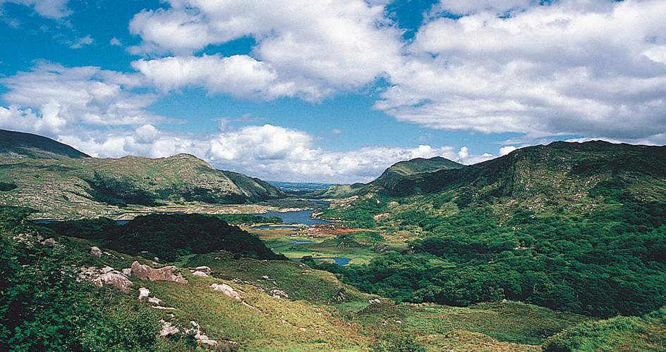
The rugged mountainous landscape of southern County Kerry and the Dingle Peninsula lies on hard sandstone rocks. It reaches its greatest height near Killarney in Macgillycuddy’s Reeks. This range includes Ireland’s highest mountain peak, Carrauntoohil, which rises 3,414 feet (1,041 meters). During the Ice Age, glaciers wore away the rocks, leaving behind jagged peaks, deep valleys, and many lakes. The mountainous peninsulas of Dingle, Iveragh, and Beara stretch out into the Atlantic Ocean. Between the peninsulas are the long sea inlets of Dingle Bay and Kenmare River. Valencia, the largest island, is joined to the mainland by a bridge. Other smaller but prominent islands include the Blaskets and Skelligs.
Although many people think of County Kerry as being mountainous, the northern part of the county is lowland rising gently to a low plateau. The Lakes of Killarney lie at the southern boundary of the lowland. The River Laune drains the lakes into Dingle Bay. The River Maine also flows into Dingle Bay, and farther north, the River Feale enters the estuary of the River Shannon.
History.
The best-known survivals of early settlement on the remote peninsulas and islands of Kerry include the Staigue Fort and remains of Celtic monasteries. Much of what is now County Kerry belonged to the Gaelic Munster kingdom of Desmond, which was ruled by the McCarthys in early medieval times.
During the 1200’s, parts of County Kerry came under Anglo-Norman control, principally that of the Fitzgeralds. From the 1580’s, the British granted some lands to settlers as part of the Plantation of Munster. Some Irish families who had lost lands farther east also moved into the county. The development of the larger towns dates from this time. Daniel O’Connell, a Roman Catholic leader of the early 1800’s, lived at Derrynane, near Waterville. His former home is now a national historic site. County Kerry suffered badly in the Great Irish Famine of the 1840’s.
