Galway, County, is the second largest county in area in the Republic of Ireland. It lies at the center of the west coast of Ireland. The western third of the county is the rugged, scenic area of Connemara, noted for its ponies. East Galway is mainly fertile lowland, well suited to agriculture. At the boundary between these two contrasting areas is the city of Galway, the largest town in the county and in the province of Connacht.
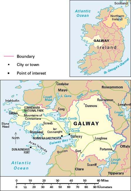
The majority of the people of County Galway are Roman Catholic. Most of the county’s population live in rural areas. County Galway has a Gaeltacht area, where people speak Gaelic (Irish) as an everyday means of communication. The Gaeltacht is mainly in the west of the county and includes the Aran Islands. The Galway Gaeltacht has the largest population of any Gaeltacht. The headquarters of the government department Roinn na Gaeltachta, the development organization Udaras na Gaeltachta, and the broadcasting station Radio na Gaeltachta are located in County Galway. Many children from other parts of Ireland go to the Galway Gaeltacht in the summer to attend Irish language schools. Many aspects of traditional Irish life have survived in the Gaeltacht, especially on the Aran Islands.
Economy.
Agriculture is an important economic activity in County Galway. Cattle and sheep production are the two main types of farming, followed by dairy farming. Sheep are more important in County Galway than in any other Irish country, and there is a local Galway breed. The sheep graze mainly on mountains in the west and on lowlands in the east. Only parts of the west are suitable for farming. The land there is poorer and farms smaller than in the east. Farmers breed hardy Connemara ponies in the west. Most of County Galway’s farmland is used for grazing. On land not used for grazing, the main crops are barley, oats, potatoes, and turnips.
The main concentration of factories is in Galway city. Others stand in Ballinasloe. Important products include electrical goods, machinery, medical products, refrigeration equipment, and transportation equipment. Other types of industry in County Galway include food processing, and the manufacture of glassware and pottery, textiles, wood products.
Galway city is a major service center. The service industries, particularly education and health care, employ nearly three-fourths of the county’s workers. Other service industries include administration and defense, financial services, retail and wholesale distribution, and transportation. National University of Ireland, Galway, is in Galway city. There are also a regional technical college and a large regional hospital.
Tourism is of great importance to County Galway, especially in the city and in Connemara. The Galway city suburb of Salthill is a major seaside resort. Connemara’s mountain and coastal scenery attracts many visitors and anglers. The government has established the Connemara National Park to conserve some of the landscape and wildlife.
Forestry is important, mainly in the county’s hills. There is a recreational forest park at Portumna. Craftworkers make ornaments from the green Connemara marble extracted from local quarries. One of Ireland’s major fishing ports is Rossaveal, in west County Galway. Shellfish are particularly important along the county’s coast.
A passenger and freight railroad extends from Galway city to Dublin. A freight-only rail line runs from north to south between Claremorris and Limerick. Galway city has a commercial port and an airport nearby. There are sea and air services to the Aran Islands.
Land.
The Atlantic Ocean forms County Galway’s western boundary, with the huge inlet of Galway Bay. The River Shannon separates the county from Counties Offaly and Tipperary to the east. County Mayo is to the north, County Roscommon to the northeast, and County Clare to the south. County Galway is about 95 miles (153 kilometers) from east to west and 50 miles (80 kilometers) from north to south.
The landscape of east County Galway is mainly lowland, except where it rises to over 1,000 feet (305 meters) in the Slieve Aughty Mountains in the south. The mountains are sandstone, but the lowland lies on limestone. Lowland soils are generally thin and dry, and farmers use the stones to build walls enclosing the fields. There are some peat bogs near the River Shannon and its tributary, the River Suck. The River Clare drains most of the western part of the lowland to Lough Corrib. Its outlet to the sea is the short River Corrib, on which Galway city is sited.
The rugged landscapes of west County Galway with their peat bogs and heathlands contrast with the gentle, green landscapes to the east of Lough Corrib. The land rises to 2,300 feet (700 meters) in the Twelve Bens and Maumturk Mountains. The highest peaks contain the mineral quartzite, but there are other ancient rocks in the vicinity. A low-lying area to the south lies mainly on granite. The coastline is fairly straight along Galway Bay, but in the west, it is deeply indented with many bays and small islands. The Aran Islands, formed of bare limestone, lie at the entrance to Galway Bay. Most of the settlements in west County Galway are along the coast.
History.
The most famous prehistoric feature in County Galway is the Dun Aonghus fort, which stands on a spectacular cliff top site on the Aran Islands. The Anglo-Norman baron Richard de Burgo captured part of the town of Galway in the 1200’s. The walled town of Galway became an Anglo-Norman outpost and later developed important overseas trade. Fourteen merchant families, or tribes, controlled the town, and it became known as the City of the Tribes.
County Galway did not come fully under British control until the 1600’s. It suffered badly in the Great Irish Famine of the 1840’s, when more than a fourth of the population was lost through death or emigration.
