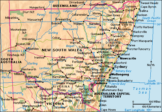
New England is a region in northern New South Wales, Australia. It is the largest area of high land in Australia. The area is not well defined. But most people consider it to include the plateau region that extends from the Macintyre River and the Queensland border in the north to the Moonbi Ranges, near Tamworth, in the south. The coastal districts of northern New South Wales form the eastern boundary of New England. The western slopes of the Great Dividing Range form the region’s western boundary. 
The plateau covers an area of more than 9,000 square miles (23,300 square kilometers). The average height of this area is a little more than 3,000 feet (914 meters) above sea level. The area has a number of mountains that are about 5,000 feet (1,525 meters) high. These mountains include Round Mountain (5,300 feet or 1,615 meters), Point Lookout (5,250 feet or 1,600 meters), Ben Lomond (4,987 feet or 1,520 meters), and Capoompeta (4,954 feet or 1,510 meters).
The height of the region makes it a good area for growing such crops as stone fruits and potatoes, which thrive in colder climates. Farmers in the area send large quantities of these crops to Sydney. Farmers raise sheep and cattle. The towns in the area include Armidale, Tamworth, Inverell, Glen Innes, and Tenterfield.
New England University College was established in Armidale in 1938 as an affiliate of the University of Sydney. It became the independent University of New England in 1954. It was Australia’s first university not in a capital city.
Many farmers and other rural New Englanders have long felt that the state’s politics were dominated by its urban centers. Several attempts have been made to form new states to represent the interests of the rural New Englanders, though none have been successful. In a state referendum in 1967, more than 30,000 voters rejected a proposal that New England should become a separate state.
