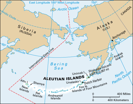
Aleutian << uh LOO shuhn, >> Islands, are a volcanic island chain that extends 1,100 miles (1,800 kilometers) west from the tip of the Alaska Peninsula. The Aleutians, part of Alaska, separate the Bering Sea from the Pacific Ocean. They include 14 large islands, about 55 smaller islands, and many islets. The mountains on the islands are part of the Alaska Range.

The Aleutians cover an area of 6,777 square miles (17,552 square kilometers). They lie 800 to 1,000 miles (1,300 to 1,600 kilometers) south of the Arctic Circle between the 51st and 55th parallels. This places the islands in the same latitude as England.
The Aleutians have many hot springs, as well as many cool springs and swift streams, on some of the islands. No trees grow there, but the islands have many varieties of small shrubs, flowers, grasses, and mosses. The climate is cool and foggy. The principal industry is fishing. A few sheep ranches operate there. The population of the islands is about 9,000.
The Aleutian Islands are divided into five main groups from east to west. These include the Fox Islands, Islands of Four Mountains, Andreanof Islands, the Rat Islands, and the Near Islands. Unimak, largest of the Aleutian Islands, has the highest mountain in the chain, Shishaldin Volcano (9,372 feet, or 2,857 meters). The village of Unalaska, on the island of the same name, is the trading center of the Aleutians and one of the leading fishing ports in the United States. Unalaska is the second largest island in the chain. It is the site of Dutch Harbor, which served as a United States naval air base during World War II (1939-1945).
