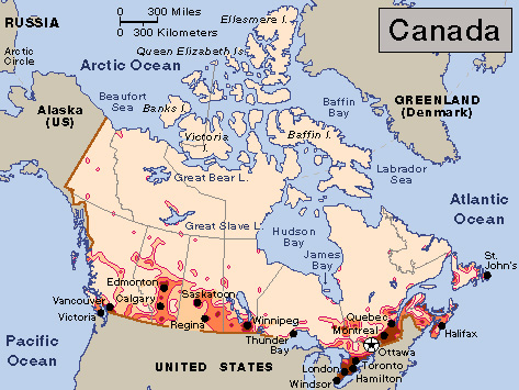
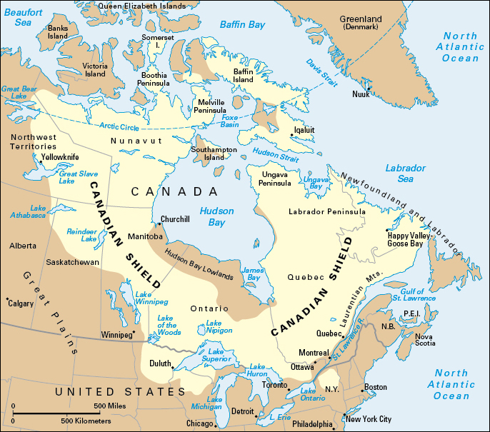
Canada is the second largest country in the world in area. Only Russia covers more land. Canada extends across the continent of North America, from the province of Newfoundland and Labrador on the Atlantic coast to the province of British Columbia on the Pacific coast. The nation’s name probably comes from kanata-kon, an Iroquois word that means to the village or to the small houses.
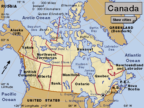
Canada is slightly larger than the United States, its southern neighbor, but has only about one-ninth as many people. Most of Canada’s people live within 60 miles (100 kilometers) of the southern border. Much of the rest of Canada is uninhabited or thinly populated. Ottawa is the capital of Canada, and Toronto is the largest city. Both Ottawa and Toronto are in the province of Ontario.
Canada is a land of much variety. Towering mountains, clear lakes, and lush forests make Canada’s far west a region of great natural beauty. Farther inland, fields of wheat and other grains cover vast prairies. These fertile farmlands contrast vividly with the harsh Arctic lands to the north. Most of the nation’s largest population centers and industrial areas lie near the Great Lakes and the St. Lawrence River in central Canada. In the east, fishing villages and sandy beaches dot the Atlantic coast.
Like Canada’s landscape, the country’s people are also varied. Most Canadians have ancestors who are of English, French, Irish, or Scottish descent. The Canadian government recognizes both English and French as official languages. French Canadians, most of whom live in the province of Quebec, have kept the language and many customs of their ancestors. Other large ethnic groups include Chinese, East Indian, German, Italian, and Ukrainian people. Large numbers of Asians live in Western Canada and Ontario. Canada’s Indigenous (native) peoples include First Nations, Inuit, and Métis. First Nations are the various peoples that descended from the original inhabitants of what is now Canada. The Inuit are descended from people who once lived in the Bering Sea region. Métis are people of mixed European and First Nations descent.
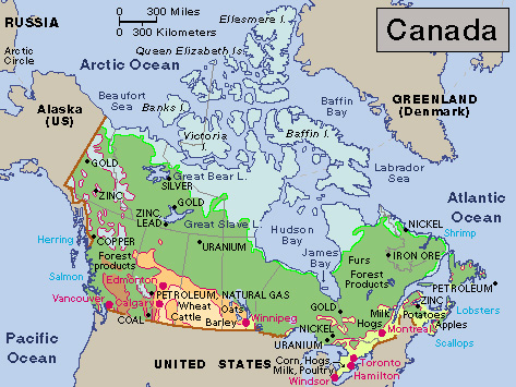
Canada’s greatest possession is its wealth of natural resources. European settlers first came to Canada to fish in its coastal waters and to trap fur-bearing animals in its forests. Later, the forests provided timber for shipbuilding and other construction. Today, pulpwood from these forests enables Canada to lead the world in the production of newsprint (paper for newspapers). Fertile soil makes Canada a leading wheat producer. Thanks to power plants on its rivers, Canada ranks high in the generation of hydroelectric power. Plentiful petroleum, iron ore, and other minerals provide raw materials that help make Canada a top manufacturing nation.
Canada is a federation (union) of 10 provinces and 3 territories. Differences among the provinces and territories have sometimes gotten in the way of Canada’s sense of community. Some Canadians in eastern and western areas think the federal government does not pay enough attention to their particular problems and interests. French Canadians make up about 80 percent of the population of Quebec. Many of these people believe that the Canadian constitution should recognize Quebec’s difference from the rest of Canada. Quebec has passed legislation aimed at making French the only official language of provincial government. 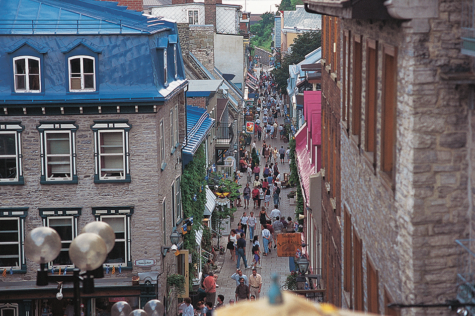
Canada is an independent, self-governing nation. But the Constitution Act of 1982 recognizes the British monarch as Canada’s official head of state. This position symbolizes the country’s historic ties to the United Kingdom. The United Kingdom completely ruled its territory in what is now Canada from the mid-1700’s until 1848. That year, settlers in Canada began to gain control of their domestic affairs. The United Kingdom continued to govern Canada’s foreign affairs. In 1931, the Statute of Westminster made Canada independent. The Constitution Act of 1982 eliminated the need for British approval of Canadian constitutional amendments.
Canada and the United States have had a relationship of cooperation and friendship since the 1800’s. The United States has had a powerful influence on Canada’s culture and economy. The Canadian economy is one of the strongest in the world. International surveys consistently rank Canada as one of the most desirable countries in which to live.
The nation
Canada has six main cultural and economic regions. They are Atlantic Canada, Quebec, Ontario, the Prairies, British Columbia, and the territories.
Atlantic Canada
lies on the Atlantic Ocean. Its four provinces—New Brunswick, Newfoundland and Labrador, Nova Scotia, and Prince Edward Island—make up about 5 percent of Canada’s land area. Most of the people are of British descent. New Brunswick, Nova Scotia, and Prince Edward Island are also called the Maritimes. Maritime means on the sea or near the sea.
Atlantic Canada has long been an important fishing center. The four provinces still provide most of Canada’s fish catch. However, the fishing industry employs only a small percentage of the provinces’ workers. Service industries, which include such activities as banking, health care, advertising, and shipping, employ most of the region’s workers. Agriculture, manufacturing, and mining are also important. Newfoundland and Labrador’s offshore Hibernia oil field, which began production in 1997, has become a major employer.
A drastic drop in cod stocks led the federal government to ban nearly all cod fishing off the Atlantic coast. As a result, thousands of people who earned their living in the fishing industry lost their jobs. New jobs have been added, including some involving petroleum production. However, Atlantic Canada has a lower standard of living, lower wages, and a higher rate of unemployment than any other part of Canada.
Quebec
differs greatly from the rest of Canada because of its French language and culture. The French explorer Samuel de Champlain founded Quebec City, the first permanent European settlement in Canada, in 1608. Quebec remained a French colony until the United Kingdom gained control of it in 1763. Today, most of Quebec’s people have French ancestry. French is the official language of Quebec. 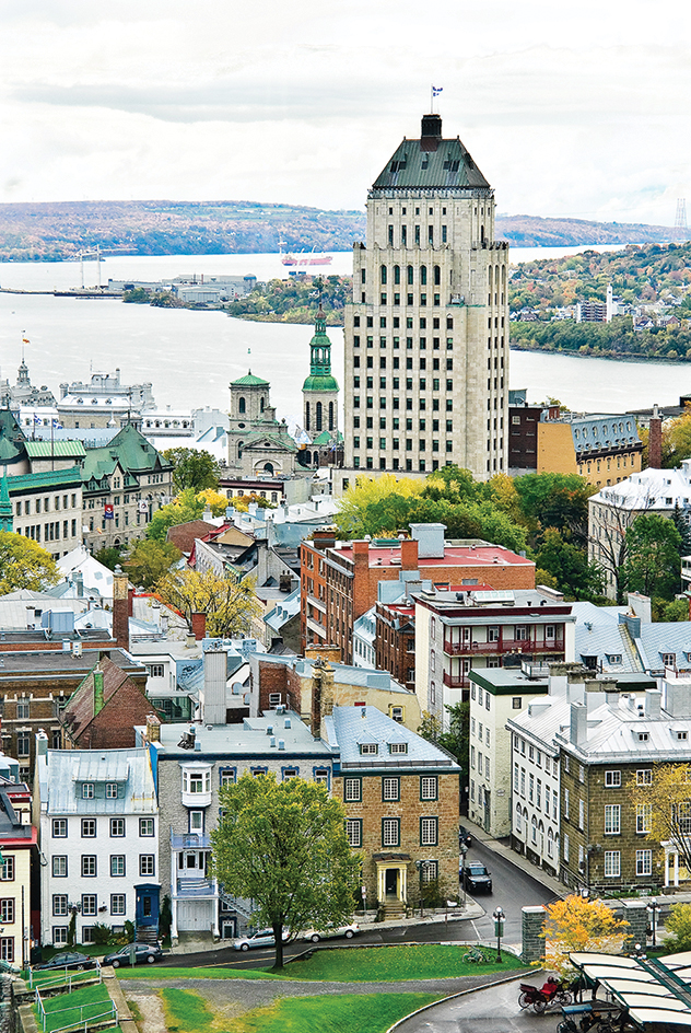
In the past, the Roman Catholic Church dominated Quebec’s politics and daily life. Today, the church generally has a less important role in the lives of the people of Quebec. For example, the feast day of Saint Jean Baptiste (Saint John the Baptist) in June is now celebrated largely as a secular (nonreligious) holiday. It serves as an occasion for the French-speaking people of Quebec to display their pride in their province.
Quebec is the largest province in area and the second largest in population. Only Ontario has more people. Montreal, Quebec’s largest city, is the hub of the province’s economic and cultural life. The largest industries in the Quebec region are service industries and manufacturing. Other important economic activities include agriculture, mining, forestry, and fishing.
Ontario
has a larger population than any other Canadian province. Fur traders explored Ontario during the 1600’s, but major European settlement did not begin until the late 1700’s. The province has many people of English, French, German, Irish, Italian, and Scottish descent. In addition, Ontario has more First Nations people than any other province.
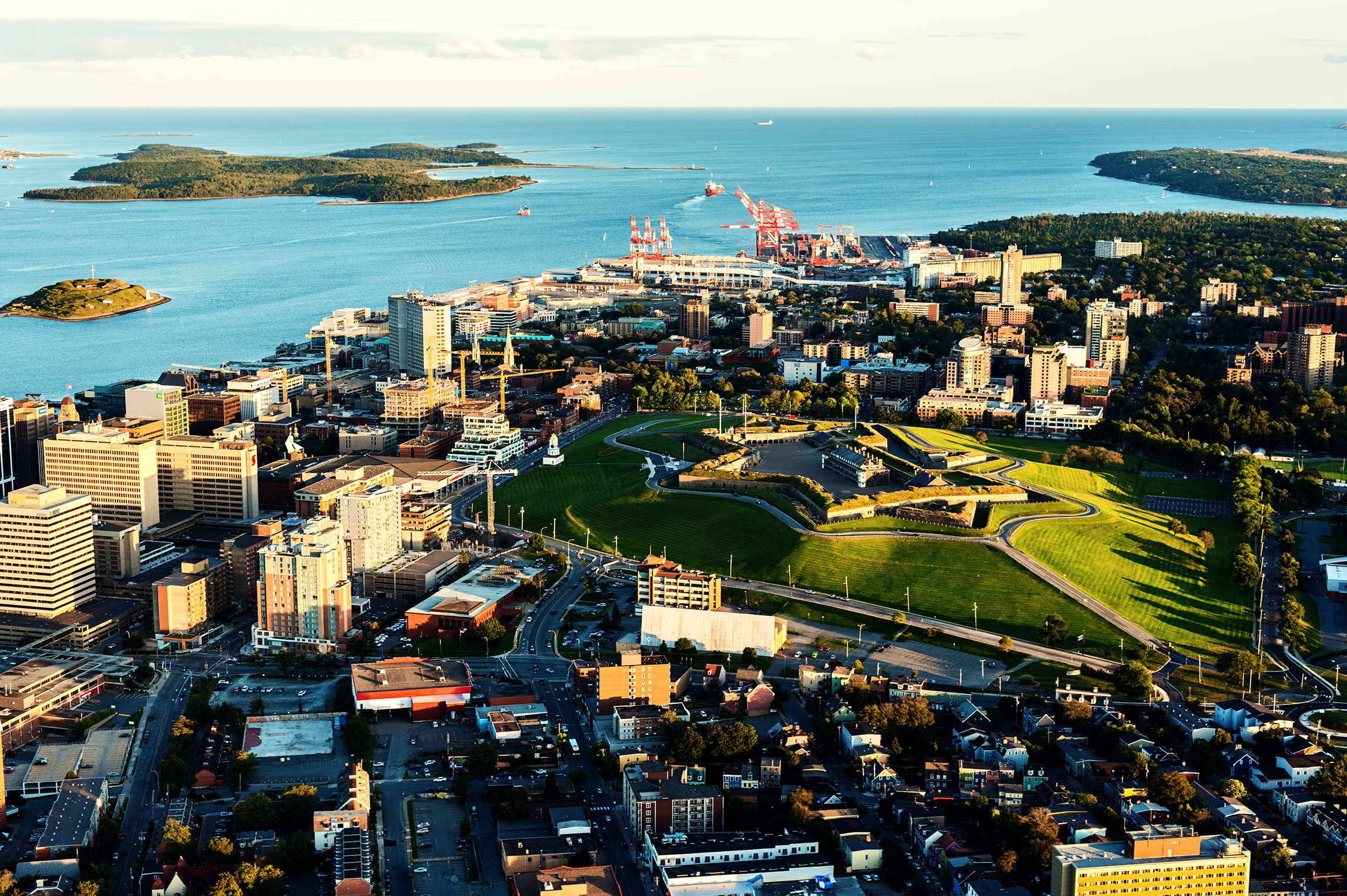
The southern boundary of Ontario passes through four of the five Great Lakes—Erie, Huron, Ontario, and Superior. The province’s principal manufacturing area, sometimes called the Golden Horseshoe, lies on the western shore of Lake Ontario. The area’s cities include Hamilton, St. Catharines, and Toronto. Ontario produces about two-fifths of Canada’s manufactured goods. It also ranks as the leading agricultural province. Toronto is the capital of Ontario and the largest city in Canada. It is the most important communications, cultural, financial, and manufacturing center in English-speaking Canada. 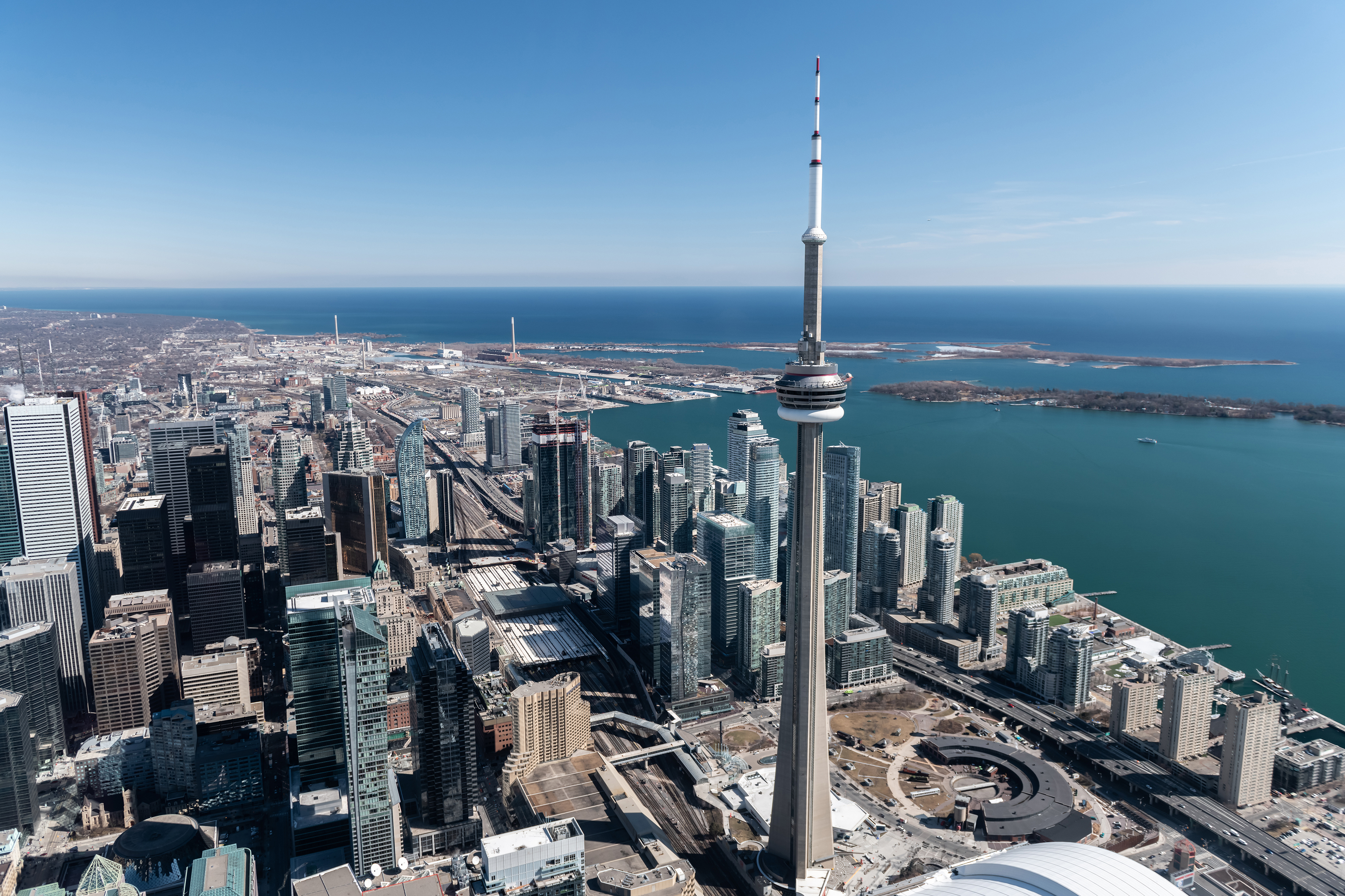
The Prairies
region includes Alberta, Manitoba, and Saskatchewan. These three provinces make up about a fifth of Canada’s land area. The southern part of the region has many grain farms and cattle ranches. Lakes and evergreen forests cover the northern area. 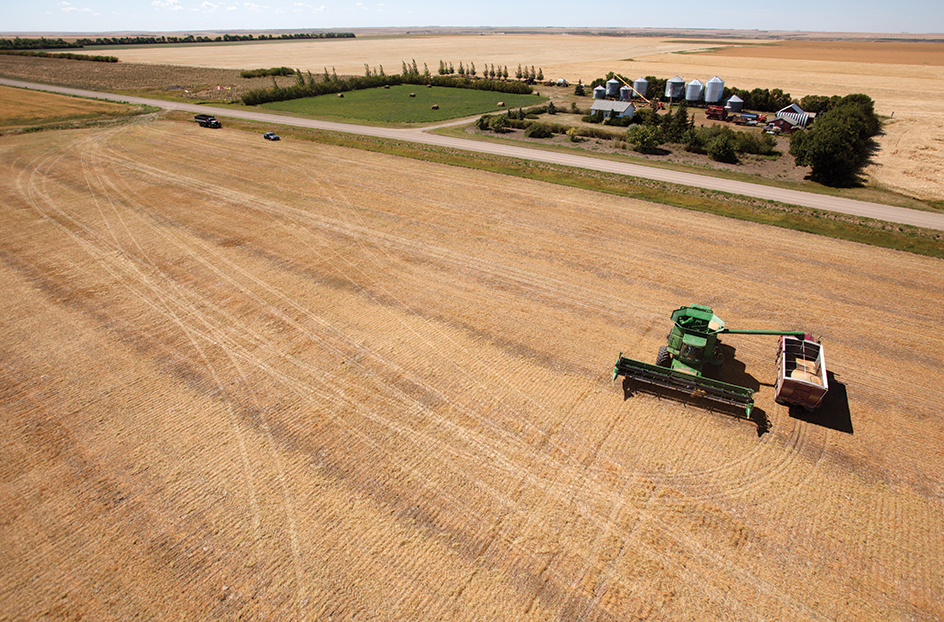
Until 1885, the Prairie Provinces were isolated from eastern Canada. The fur trade was the region’s only important economic activity. After the completion of Canada’s first transcontinental railroad in 1885, travelers and goods could reach the region easily. Hundreds of thousands of people settled on the fertile prairies in the late 1800’s and early 1900’s. Most of them came from eastern Canada, Germany, Italy, the Netherlands, Poland, Scandinavian countries, Ukraine, and the United States.
For years, the economy of the Prairies relied on agriculture. The region still produces most of Canada’s grain and cattle. In the late 1940’s, the discovery of petroleum and natural gas in the area provided a new source of wealth. These resources formed the basis for further changes in the economy of the Prairies. Manitoba is now a major manufacturer of buses and of automobile and aircraft parts. Saskatchewan is one of the world’s leading producers of potash-based fertilizers. Alberta has one of the world’s largest oil reserves and produces most of Canada’s natural gas. The largest cities in the Prairies are Calgary, Alberta; Edmonton, Alberta; and Winnipeg, Manitoba. 
British Columbia
is Canada’s westernmost province and its third largest in both area and population. It lies on the Pacific Ocean. British Columbia’s largest city, Vancouver, has Canada’s busiest port. The beauty of the province’s rugged coastline and lofty mountains attracts many tourists. The southern part of British Columbia has Canada’s mildest climate. Many older Canadians move to the province after they retire. 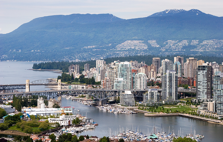
Over half of the province’s people have some English, Irish, or Scottish ancestry. Other large ethnic groups include the French and German. British Columbia has a higher percentage of Asians than any other province, especially people of Chinese and East Indian descent.
Evergreen forests cover much of British Columbia. Many of the province’s people work in the logging and wood-processing industries. Other major economic activities include mining and service industries.
The territories.
The Northwest Territories, Nunavut, and Yukon make up more than a third of Canada’s land area. But because of the remote location and severe climate of the territories, few people live there. The terrain in Yukon and in the southwestern part of the Northwest Territories consists mainly of forest-covered mountains. Most of the rest of the region remains frozen for much of the year. The territories have rich mineral deposits, and mining is the chief economic activity. 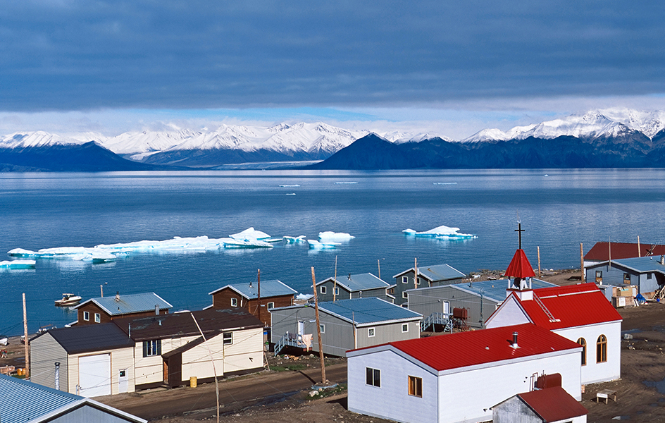
The First Nations and Inuit peoples made up almost the entire population of the territories until the region’s great mineral wealth was discovered in the late 1800’s and early 1900’s. Whitehorse, the capital of Yukon, was founded during the Klondike gold rush of the 1890’s. Yellowknife, the capital of the Northwest Territories, was established during another gold rush in the 1930’s.
Iqaluit, the capital of Nunavut, already served the Inuit as a seasonal fishing camp when Europeans arrived in the area in 1576. Iqaluit’s population remains mostly Inuit, as does the population of Nunavut as a whole.
People
Population.
Canada’s population has grown dramatically since the late 1800’s. The increase in population has resulted from heavy immigration and, earlier in Canadian history, a high birth rate.
Over the years, the many immigrants to Canada have changed the country’s ethnic makeup. From about 1900 until World War I began in 1914, most immigrants came from Ireland, the United Kingdom, and the United States. European Jews and others from Europe—including Italians, Poles, and Ukrainians—also came in large numbers. After World War II ended in 1945, immigrants to Canada were mainly British, Dutch, German, or Italian. Many of these people had lost their homes in the war.
Today, more immigrants to Canada come from China, India, the Philippines, and other Asian countries than from any other area of the world. Many also come from Africa, the Caribbean, and Central and South America. Canada’s immigration rate is double that of the United States. Toronto is one of the most ethnically and linguistically diverse cities in the world.
Ancestry.
Most Canadians are of European descent. People of First Nations, Inuit, and Métis descent make up about 3 percent of the nation’s population. Most of Canada’s people have some ancestors who came from France, Ireland, or the United Kingdom. Other large ethnic groups include Chinese, East Indians, Germans, Italians, and Ukrainians.
Europeans.
People of British and Irish ancestry make up the majority of the population of every province except Quebec. Many are descendants of Scottish settlers who began arriving in Canada during the late 1700’s. The ancestors of many others were English and Irish settlers who flocked to Canada during the 1800’s. Still others are descendants of United Empire Loyalists—people who moved from the United States to Canada during and after the American Revolution (1775-1783).
About 65,000 French colonists lived in Quebec when France lost that region to the British in 1763. Since that time, the number of Canadians with French ancestry has grown to more than 5 million. Most live in Quebec, but Ontario and New Brunswick also have large numbers of people with French backgrounds. The rest of Canada also has a few areas that are largely French.
About 10 percent of Canadians have some German ancestry, 5 percent have Italian ancestry, and 4 percent have Ukrainian ancestry. Most German Canadians live in British Columbia, Ontario, and the Prairies. People of Italian descent live chiefly in the cities, particularly Toronto and Montreal. Most Canadians of Ukrainian origin live in the Prairies. Many other Canadians are of Dutch, Greek, Hungarian, Polish, Portuguese, or Scandinavian origin.
The First Nations and Inuit
had lived in Canada for thousands of years when Europeans arrived. Today, about 760,000 First Nations people live in Canada. About 55,000 Canadians are Inuit. The word Inuit means people. The Inuit of Canada once were called Eskimos. Today, many Inuit view the term Eskimo as belittling. 
About half of the Inuit population lives in Nunavut. Most of the rest live in the Northwest Territories and in the northern areas of Newfoundland and Labrador, Ontario, and Quebec. First Nations people are often classified by their traditional languages. The major languages spoken by Canada’s First Nations include Cree, Ojibwa (also called Chippewa), Innu (also called Montagnais-Naskapi), Mi’kmaq, Dene, Dakota/Sioux, and Blackfoot (also called Blackfeet). About 40 percent of Canada’s First Nations people live on about 2,700 reserves (reservations).
Other Canadians
include people from China, India, Pakistan, Vietnam, and other Asian countries. Asians make up much of the population of British Columbia. Many immigrants from China, the Indian subcontinent (mostly Bangladesh, India, and Pakistan), and the Caribbean Islands live in Toronto and Vancouver. Black people make up about 4 percent of Canada’s population. Many Black Canadians are from the Caribbean region, both from English-speaking islands and from French-speaking Haiti. 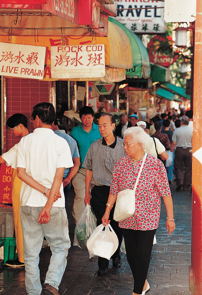
Languages.
Canada has two official languages, English and French. The Official Languages Act of 1969 guarantees all Canadians the right to communicate with the national government in either French or English. About two-thirds of the Canadian people speak mainly English at home, and about one-fifth speak mainly French. About one-seventh speak other languages, such as Chinese, Italian, German, Punjabi, and Spanish.
Many of Canada’s Inuit and First Nations people use their traditional languages at home, though they may speak other languages as well. About 50 First Nations and Inuit languages are spoken in Canada.
Significant numbers of French-speaking people live in New Brunswick and Ontario. However, most of the French-speaking Canadians live in Quebec, and French is the official language of the province. Quebec’s French-speaking citizens, called Québécois << kay beh KWAH, >> consider themselves to be the guardians of the French language and culture in Canada.
The role of the French language and culture in Quebec has been controversial both within the province and within Canada as a whole. Quebec’s legislature has passed a number of laws dealing with the uses of French and English in the province. In the 1970’s, for example, the legislature passed laws that made French the language of government and business. Among other provisions, the laws banned the use of English on commercial signs. English-speaking citizens of Quebec opposed these laws. Through a series of court rulings and legislation, the laws were eventually changed. Today, bilingual advertising—in French and English—is allowed on commercial signs as long as the French lettering is larger than the English.
Way of life
City life.
Canada began as a nation with a largely rural population. But today, about 80 percent of Canadians live in urban areas. This population shift began mainly as a result of the rapid development since the 1940’s of manufacturing and service industries in urban areas. Expressway systems link the city centers with the numerous suburbs that have sprung up around them.
Most Canadian city dwellers work for the federal or provincial government, in the retail trades and other service industries, or in manufacturing. Occupations vary from city to city. In Vancouver, for example, many jobs involve the forest industry. In Toronto and other places in southern Ontario, automobile production is the main manufacturing industry. In Winnipeg and Montreal, construction of aircraft and aircraft parts provides many jobs. Halifax and Vancouver rank as major ports.
The rapid growth of Canadian cities has brought some challenges. The spread of suburbs into valuable farmland has led many Canadians to oppose unlimited urban growth. Some of Canada’s cities have faced reductions in transportation and welfare funds. In addition, immigration has contributed to tensions among different ethnic groups.
Rural life.
A small percentage of rural Canadians live on farms. Others work in such industries as fishing, mining, and lumbering. A small but growing number of Canadians live in rural communities and commute to jobs in the cities.
Most farmers in Canada own their farms, and farming is largely a family activity. Modern machinery enables a family to do nearly all the work on their farm themselves. The largest Canadian farms are in the Prairies and cover an average of about 1,200 acres (486 hectares). Farms in central and eastern Canada are smaller, averaging about 180 to 300 acres (73 to 120 hectares).
Farm life has changed greatly since the early 1900’s, especially in the Prairies. The once-extensive network of prairie railroad branch lines, with their wooden grain elevators and small towns, is rapidly disappearing. Large concrete and steel inland grain terminals have replaced most country elevators. Many farmers now drive much farther than they once did to sell their grain at these inland terminals. Larger towns, with modern shopping malls and warehouse outlets, have grown up around these terminals.
On the farms themselves, satellite dishes and the Internet connect rural families to the rest of the world. Many farmers use computers and the Global Positioning System (GPS) to help with their work.
Arctic life.
Canada’s vast Arctic region is thinly populated. Inuit and First Nations people have lived there for thousands of years. Today, they form about 40 percent of the region’s population.
Some Inuit and First Nations people still make their living by their traditional occupations—fishing, hunting, and trapping. In general, however, traditional ways of life in the Arctic have ended. The people live in wooden houses rather than tents or snowhouses. They wear modern clothing and eat food bought in stores. Snowmobiles and motorboats largely have replaced dog sleds and kayaks as the chief means of transportation.
The decline of traditional life has led to many social problems. The Inuit population has high rates of alcoholism, crime, suicide, and unemployment. However, economic conditions may improve with the development of petroleum and other natural resources in the Arctic. Managers of corporations with operations in the region routinely consult with Inuit leaders. Corporate and Inuit leaders cooperate to establish vocational training so that Inuit youths can get and keep jobs.
Education.
Religious groups operated the earliest schools in Canada. In 1867, the British North America Act made education a responsibility of the provincial governments. Today, each province and territory in Canada has its own school system. A provincial or territorial department of education supervises each school system. A cabinet minister heads each department of education and reports to the legislature of the province or territory. The federal government is responsible for directing the education of children on First Nations reserves, the children of members of the Canadian Armed Forces, and the inmates of federal penitentiaries. 
Most provincial school systems have 12 grades. Quebec’s school system has 11. Some provinces use public funding to support private schools in addition to public schools. In Quebec, most students are required to receive instruction in French through secondary school. Exceptions are made for some students, such as those who have received most previous instruction in English-language Canadian schools.
The major English-language universities in Canada include McGill University; the universities of Alberta, British Columbia, Toronto, and Western Ontario; and York University. The most important French-language institutions are Université Laval (Laval University), the Université de Montréal (University of Montreal), and the Université du Québec à Montréal (University of Quebec at Montreal). The Université de Moncton (University of Moncton) in New Brunswick and Université Sainte-Anne (Ste. Anne University) in Nova Scotia also teach in French. Some universities teach in both English and French. The largest of these bilingual institutions is the University of Ottawa in Ontario.
Quebec also has collèges d’enseignement général et professionel (colleges of general and professional instruction). They offer a two-year course that high school graduates must complete before enrolling in a Quebec university. They also provide three-year technical and commercial courses. The other provinces also have two-year or three-year institutions of higher learning. Most of these schools are called community colleges.
The federal and provincial governments provide much funding for university education. Canadian students pay about 20 percent of the cost of their education through their fees. Costs for foreign students attending Canadian universities are higher. Canada’s low tuition costs help it to have one of the highest rates worldwide of students enrolled at postsecondary institutions.
Canada has a high literacy rate and an extensive public library system. Library and Archives Canada is the country’s national library. It produces Canadiana, a monthly and annual listing of new books, pamphlets, and music published in Canada. The Canada Institute for Scientific and Technical Information operates a science library in Ottawa.
Canada has a rich variety of museums and art galleries. National museums in Ottawa include the Canadian Museum of History, the Canadian Museum of Nature, the Canada Science and Technology Museum, the Canadian War Museum, and the National Gallery of Canada. Another outstanding museum is the Royal Ontario Museum in Toronto. It has exhibits in such fields as archaeology, geology, and zoology. The Royal Tyrrell Museum of Palaeontology in Drumheller, Alberta, is one of the world’s leading dinosaur museums. Notable Canadian art galleries include the Art Gallery of Ontario, the Vancouver Art Gallery, and the Winnipeg Art Gallery. 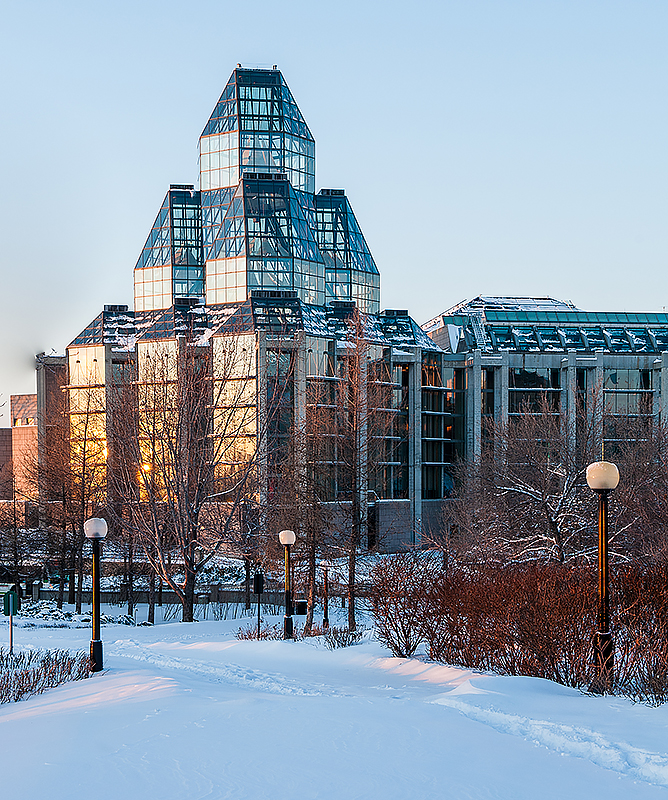
Religion.
The early French settlers brought the Roman Catholic faith to Canada. Catholics are the nation’s largest religious group today. Most other Canadians belong to Protestant churches. The largest Protestant denominations are the United Church of Canada and the Anglican Church of Canada. Other major Protestant groups in Canada include Baptists, Lutherans, and Presbyterians. The country’s other religious groups include Buddhists, Hindus, Jews, Muslims, and Sikhs. 
Recreation and sports.
Canadians take part in a wide variety of recreational activities. During the long winters, many people enjoy curling, hockey, skating, downhill and cross-country skiing, snowboarding, and tobogganing. Popular summer sports include canoeing, fishing, golf, hiking, swimming, and tennis. 
Canada’s extensive national park system includes areas for many recreational activities. The park system began in 1885 with the establishment of Banff Hot Springs Reservation (now Banff National Park) in Alberta. Today, all the provinces and territories have at least one national park. Each province also has its own park system. For information on the national parks and other parklands of Canada, see the tables with this article. 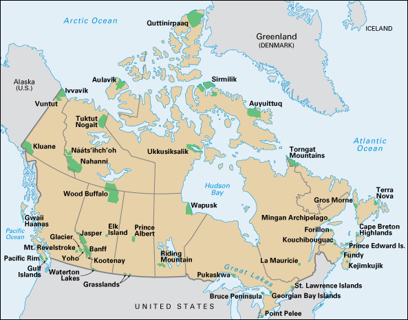
Canada’s first national game was lacrosse, which the First Nations played before Europeans arrived in North America. Today, hockey is by far the most popular sport in Canada. Canadian boys and girls may begin competing in amateur hockey leagues when they are 7 years old. Professional teams from Canada and the United States compete in the National Hockey League (NHL), the highest professional hockey league. More than half the players in the National Hockey League are Canadians. Such stars as Sidney Crosby, Wayne Gretzky, Gordie Howe, Guy Lafleur, Bobby Orr, and Maurice Richard became national heroes in Canada.
Other popular professional sports in Canada include baseball, basketball, football, and soccer. Teams from major Canadian cities compete in the Canadian Football League (CFL). The Toronto Blue Jays attract baseball fans from throughout Canada. The Toronto Raptors play in the National Basketball Association (NBA).
Canada has hosted the Olympic Games several times since the 1970’s. Canadian athletes typically excel at many of the winter sports.
Food.
Canadians eat more beef, including roast beef and steaks, than any other meat. Bread is part of most meals, and potatoes are also common. Other favorite vegetables include beans, carrots, lettuce, and peas. Apples, bananas, berries, and citrus fruits are popular.
Coffee and tea, milk, soft drinks, and beer and wine are popular beverages. Favorite desserts include ice cream and fruit pies, especially apple, blueberry, peach, and rhubarb pies. Canada also produces the majority of the world’s maple syrup, which usually is served over pancakes and waffles.
Roast turkey is a popular dish at Thanksgiving, Christmas, and New Year’s. On Christmas, many French Canadians eat a meat pie called tourtière. Immigration has helped make foods from throughout the world popular.
Many Canadians eat out often. Specialty restaurants, once common only in major cities, now also operate in smaller cities throughout the country. These include seafood restaurants and ethnic restaurants, such as those that serve Chinese, French, Greek, Indian, Italian, Japanese, Thai, or Vietnamese food.
The arts
Government support has played a vital role in the development of the arts in Canada. In 1957, the Canadian government set up the Canada Council for the Arts to promote the advancement of the visual and performing arts and literature. The council provides financial assistance to individual artists and to orchestras, theaters, and other organizations. Provincial and local governments also have contributed strong financial support for the arts. Thanks in part to governmental support, Canadian artists’ work has become known around the world.
In 1969, the federal government opened the National Arts Centre in Ottawa. The Arts Centre presents ballet, drama, motion pictures, music, and opera. The National Gallery, also in Ottawa, has an excellent collection of European art and a large number of Canadian works.
Literature.
Canada has two great literatures, one in French and the other in English. Important modern writers from Canada have included Margaret Atwood, Alice Munro, and Michael Ondaatje. For a discussion of Canadian writers and their works, see Canadian literature.
Painting and sculpture.
The works of most early Canadian painters followed European trends. During the mid-1800’s, Cornelius Krieghoff, a Dutch-born artist in Quebec, painted scenes from the lives of French Canadian farmers called habitants. At about the same time, the Canadian artist Paul Kane painted pictures of First Nations life in western Canada. 
A group of landscape painters called the Group of Seven developed the first distinctively Canadian style of painting. Tom Thomson, one of Canada’s best-known painters, inspired the group, but he died three years before the group’s first exhibition in 1920. All these artists painted large, brilliantly colored scenes of the Canadian wilderness.
Canadian painters have developed a wide range of styles since the Group of Seven. Emily Carr, for example, became famous for painting the totem poles and forests of British Columbia. Other noted artists have included landscape painter David Milne, abstract painters Jean-Paul Riopelle and Harold Town, First Nations painter Norval Morrisseau, photographer Yousuf Karsh, and multimedia artist Michael Snow.
The finest works of Canadian sculpture include woodcarvings of the Haida, Kwakiutl, and other First Nations of Canada’s northwest coast. Other fine works include ivory and soapstone carvings by Inuit artists. Bill Reid, for example, used his Haida heritage as a source of design for his totem poles and other sculptures.
Theater.
Canada’s best-known theatrical event is the Stratford Festival, held annually in Stratford, Ontario. Famous performers appear in the plays of the great English playwright William Shakespeare and other noted dramatists. Another major annual drama festival is the Shaw Festival. This festival is held in Niagara-on-the-Lake, Ontario, and features works by the Irish-born British playwright George Bernard Shaw and other dramatists of the late 1800’s and early 1900’s. The leading theater group in French-speaking Canada is Le Théâtre du Nouveau Monde in Montreal. Cirque du Soleil, based in Montreal, is an entertainment company known for its acrobatic performers and striking special effects. Canada also has many regional theater companies. The Edmonton International Fringe Theatre Festival attracts hundreds of thousands of people to Edmonton every August. Leading playwrights from Canada include Tomson Highway, who writes in both the Cree language and English; Sharon Pollock, and George F. Walker, who write in English; Michel Tremblay, who writes in French; and Robert Lepage, who uses both languages. 
Music.
Canada’s outstanding orchestras include the National Arts Centre Orchestra, the Orchestre Symphonique de Montréal (Montreal Symphony Orchestra), the Toronto Symphony Orchestra, and the Vancouver Symphony Orchestra. Solo performers who have gained recognition include the pianists Janina Fialkowska, Glenn Gould, and Jon Kimura Parker; and the cellists Ofra Harnoy and Shauna Rolston. Canadian popular music stars have included Bryan Adams, Justin Bieber, Michael Bublé, Leonard Cohen, Céline Dion, Gordon Lightfoot, Sarah McLachlan, Joni Mitchell, Alanis Morissette, Anne Murray, Shania Twain, and Neil Young. 
Ballet and opera.
Canada has several professional ballet companies. The oldest, the Royal Winnipeg Ballet, was founded in 1938. It performs many original Canadian works. The National Ballet of Canada in Toronto and Les Grands Ballets Canadiens in Montreal both tour extensively. The National Ballet has featured such noted Canadian dancers as Frank Augustyn, Rex Harrington, Karen Kain, Martine Lamy, and Veronica Tennant.
The Canadian Opera Company performs in Toronto. Several other Canadian cities have opera companies. Outstanding Canadian opera singers have included Measha Brueggergosman, Maureen Forrester, Ben Heppner, Lois Marshall, Louis Quilico, and Jon Vickers.
Motion pictures.
The Canadian motion-picture industry began in 1939 with the founding of the National Film Board of Canada. The government-sponsored board has won hundreds of awards for documentaries and animated films. In 1967, the government set up the Canadian Film Development Corporation, which helped establish Canada’s feature-length film industry. Known today as Telefilm Canada, the organization administers funds for both motion pictures and television programs. 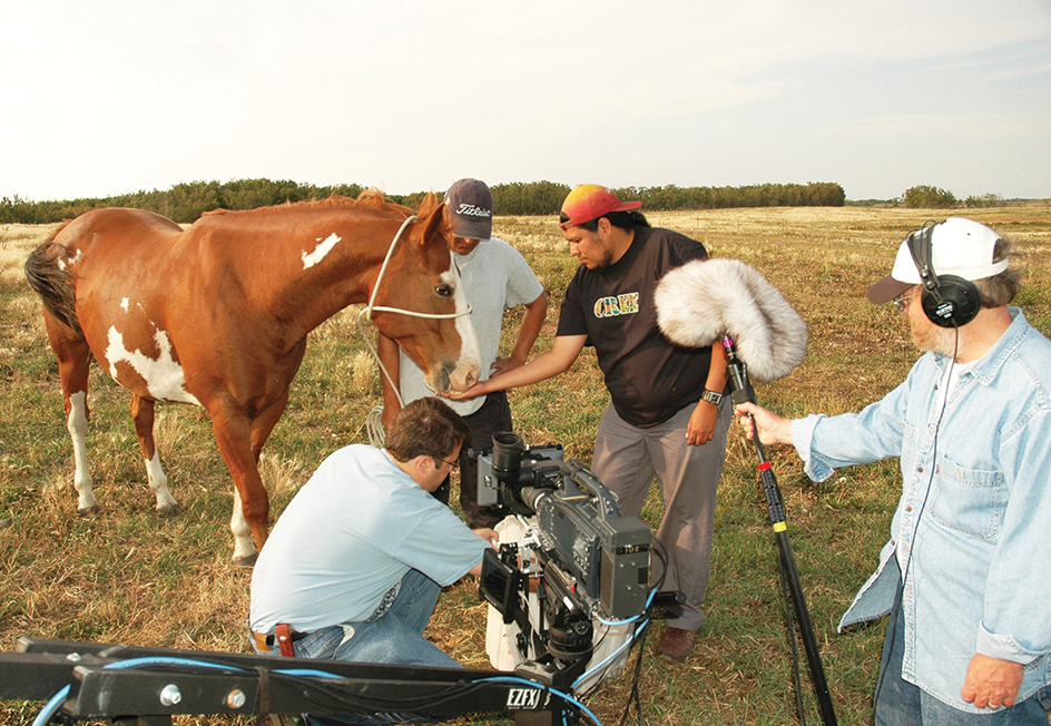
Thousands of Canadians work in the motion-picture industry. Hollywood studios film many movies, or parts of them, in Canada. Many movie companies find it less expensive to film in Canada than in the United States. Calgary, Montreal, Toronto, and Vancouver are often used as “American” cities. Many Western movies are shot in southern Alberta. Quebec also has a strong commercial film industry that produces movies in French.
Architecture.
Examples of traditional architecture in Canada include the French-style homes of Quebec and the neo-Gothic Parliament buildings in Ottawa. Modern Canadian architecture is international in style. The Toronto-Dominion Centre in Toronto, designed by the German-born architect Ludwig Mies van der Rohe, and Place Ville Marie in Montreal, by the Chinese-born architect I. M. Pei, reflect the sleek, uncluttered glass-and-steel style of the mid-1900’s. The Toronto City Hall, one of the most impressive structures in Canada, was designed by Viljo Revell of Finland.
Arthur Charles Erickson, a famous Canadian architect, designed many buildings in British Columbia. Erickson is best known for designs that dramatically harmonize with the landscape. Moshe Safdie, an Israeli-born Canadian, first came to public attention with his housing project known as Habitat. This apartment complex, built for the Montreal World’s Fair in 1967, consists of arrangements of prefabricated cubes. Douglas Cardinal, a First Nations architect born in Alberta, used smooth, rounded forms for the Canadian Museum of Civilization, now called the Canadian Museum of History, in Gatineau, Quebec, near Ottawa. Cardinal also designed the National Museum of the American Indian in Washington, D.C. 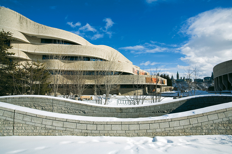
The land
Canada covers most of the northern half of North America. It borders Alaska on the northwest and the rest of the continental United States on the south. From east to west, Canada extends 3,223 miles (5,187 kilometers) from the rocky coast of Newfoundland and Labrador to the St. Elias Mountains in Yukon. Canada has six time zones. At noon in Vancouver, the time in St. John’s, Newfoundland and Labrador, is 4:30 p.m. From its southernmost point, Middle Island in Lake Erie, Canada extends 2,875 miles (4,627 kilometers) north to Cape Columbia on Ellesmere Island. Of all the world’s land areas, only the northern tip of Greenland lies nearer the North Pole than does Cape Columbia.
Canada has the longest coastline of any country—151,019 miles (243,042 kilometers), including island coasts. Canada faces the Pacific Ocean on the west, the Arctic Ocean on the north, and the Atlantic Ocean on the east. Hudson Bay, Hudson Strait, and James Bay form a great inland sea. Hudson Bay remains frozen for about eight months of the year. But in the summer, it provides a waterway to Canada’s vast interior.
Forests cover almost half of the land area of Canada. Mountains and Arctic areas make up 41 percent of the land. Most Canadians live in southern agricultural areas and along the Atlantic and Pacific coasts.
Land regions.
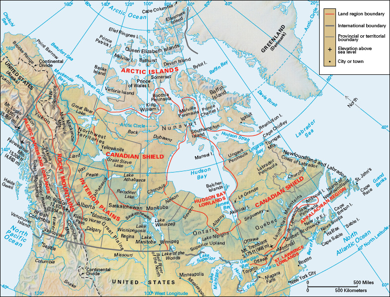
Canada has eight major land regions. They are the Pacific Ranges and Lowlands, the Rocky Mountains, the Arctic Islands, the Interior Plains, the Canadian Shield, the Hudson Bay Lowlands, the St. Lawrence Lowlands, and the Appalachian Region.
The Pacific Ranges and Lowlands
form Canada’s westernmost land region. They make up most of British Columbia and the southwestern part of Yukon. The region includes the Haida Gwaii island group and Vancouver Island. All these islands are the upper portions of a mountain range that is partly covered by the Pacific Ocean. The Coast Mountains rise along the coast of British Columbia. The St. Elias Mountains in Yukon include Canada’s highest peak, Mount Logan, near the Alaskan border. It towers 19,551 feet (5,959 meters) above sea level. Glaciers cover many of the higher slopes in the St. Elias Mountains. 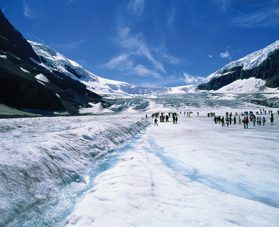
The coastline of British Columbia has many long, narrow inlets called fiords. The fiords provide a water route to Canada’s most valuable forests. These dense forests consist of tall redcedars, hemlocks, and other evergreen trees that grow on the lower slopes of the mountains. Black bears, foxes, and other animals live in the forests.
The Interior Plateau is an area of plains, river valleys, and smaller mountains. It lies east of the Coast Mountains. This area has valuable mineral resources, including Canada’s largest deposits of the metals bismuth and molybdenum. The southern part of the Interior Plateau has many farms and orchards, as well as large grasslands where cattle graze. Forests grow in the northern part of the plateau area.
The Rocky Mountains
rise east of the Pacific Ranges and Lowlands. These two regions together are part of the Cordillera, an immense group of mountain ranges that extends from Alaska through Mexico. In Canada, the snowcapped Rockies vary in height from 7,000 to more than 12,000 feet (2,100 to 3,660 meters) above sea level. The tallest peak, Mount Robson in eastern British Columbia, is 12,972 feet (3,954 meters) high. Millions of people visit the Rockies every year to view the magnificent scenery and to enjoy such activities as camping, hiking, and skiing. 
The Rocky Mountain Chain extends for more than 3,000 miles (4,800 kilometers) from New Mexico to northern Alaska. The Canadian portion of the chain includes several separate ranges. The major range, the Canadian Rockies, stretches from Canada’s southern border to the Liard River in northern British Columbia. Railroads and highways cross the Canadian Rockies at Crowsnest, Kicking Horse, Vermillion, and Yellowhead passes. Between the Liard River and the Alaskan border are several other ranges, including the Selwyn Mountains and the Mackenzie Mountains. A long, narrow valley called the Rocky Mountain Trench separates the Columbia Mountains in southern British Columbia from the Canadian Rockies to the east.
The Rockies have large deposits of coal, lead, silver, zinc, and other minerals. Forests of juniper and pine grow on the lower slopes. Firs and spruces thrive at higher elevations. Bears, deer, minks, mountain lions, and other animals roam the forests on the upper slopes. Rocky Mountain goats and bighorn sheep live above the timber line, the elevation above which trees cannot grow. Rainbow trout, cutthroat trout, grayling, and other fish swim in the swift mountain streams.
The Arctic Islands
lie almost entirely within the Arctic Circle. They include about a dozen large islands and hundreds of smaller ones. All the islands are barren, and most remain unexplored. Two of the largest islands, Baffin Island and Ellesmere Island, have many glaciers, tall mountains, and deep fiords. Victoria Island and the other western islands are extremely flat. The seas surrounding the islands remain frozen most of the year. 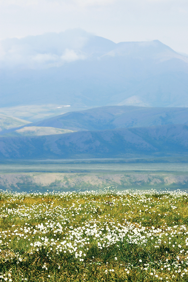
The Arctic Islands are tundras, places too cold and dry for trees to grow. The subsoil of the islands is permanently frozen, and only a thin surface layer of soil thaws during the brief, cool summers. Only simple organisms called lichens grow on the northernmost islands. The other islands have lichens, mosses, grasses, and grasslike plants known as sedges. Herds of caribou and musk oxen graze on the tundras. Other wildlife includes Arctic foxes and hares, lemmings, polar bears, ptarmigans, seals, walruses, and whales. Insects thrive on the Arctic Islands during the summer.
Deposits of petroleum and natural gas, as well as such minerals as lead and zinc, have been discovered in the western Arctic Islands. However, most of this mineral wealth remains untapped because of high production costs and the difficulty of transporting the products to distant markets.
The Interior Plains
include the northeastern corner of British Columbia, much of Alberta and Saskatchewan, and the southwestern part of Manitoba. The region extends north through the Northwest Territories to the Arctic Ocean. 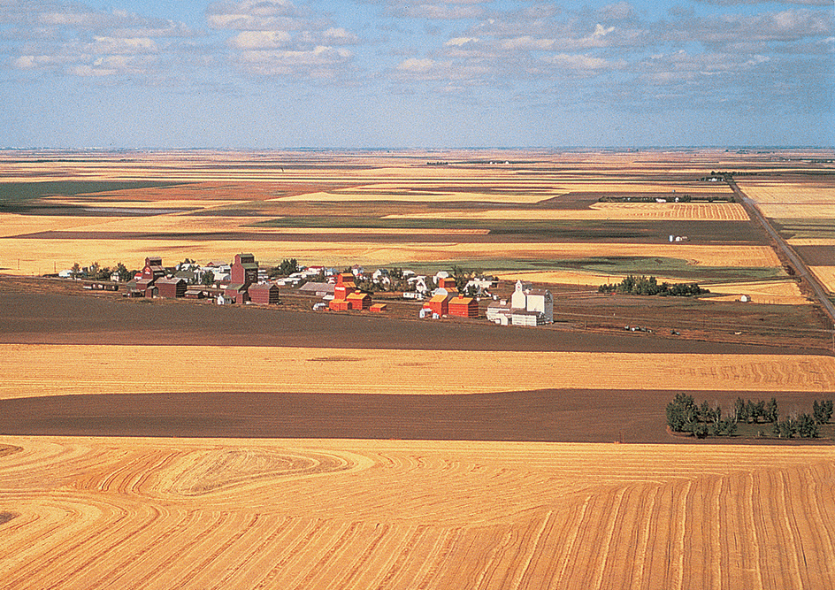
Grasslands form the natural cover of the vast prairies in the southern Interior Plains. Farmers have plowed most of the grasslands to grow wheat and other grains in the fertile black soil. Ranchers graze cattle on the remaining grasslands in the drier areas of southern Alberta. Farther north, evergreen forests form part of the great northern forest that covers Canada from Alaska to the coast of Labrador, the mainland part of Newfoundland and Labrador. White spruces and jack pines are the most common trees in these forests. Deer, elk, moose, and many other animals live there. Near the Arctic Ocean, the forests gradually give way to tundras that are covered by snow for more than half the year.
The Interior Plains have many mineral resources. Large deposits of petroleum, natural gas, and coal have made Alberta a major mining area. One of the world’s largest known deposits of bituminous sands or tar sands (sands that contain oil) lies along the Athabasca River in Alberta. Saskatchewan has important deposits of petroleum and uranium. The largest potash deposits in the world lie mainly in southern Saskatchewan. The Northwest Territories has petroleum and deposits of diamonds, lead, and zinc.
The Canadian Shield
is a vast horseshoe-shaped region. It curves around Hudson Bay from the Arctic coast of Nunavut to the coast of Labrador. The Canadian Shield covers about half of Canada and is made up of ancient rock. Much of the region lies from 600 to 1,200 feet (180 to 370 meters) above sea level. The eastern part of the region is called the Great Laurentian Uplands.
The Canadian Shield consists largely of low hills and thousands of lakes. These lakes are the sources of rivers that break into great rapids and waterfalls at the edge of the region. Many of these rivers have hydroelectric plants. The plants provide power for pulp and paper mills and other industries, as well as for towns and cities of Quebec, Ontario, and Manitoba. 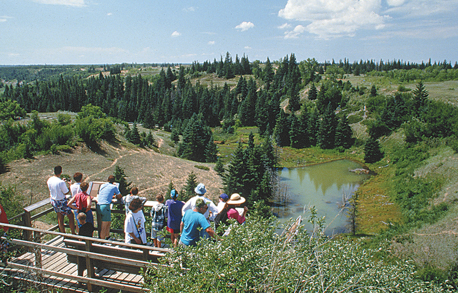
Few people live in the Canadian Shield. The region generally has poor soil and a cold climate. Only a few areas near the southern edge of the region have soil that is good enough for farming.
The southern part of the Canadian Shield is close to Toronto, Ottawa, and Montreal. Many people of these cities have vacation houses near lakes or ski slopes in the southern Canadian Shield. The northern areas of the Canadian Shield are tundras. Evergreen forests cover most of the rest of the region. Deer, elk, moose, wolves, and many smaller animals live in the forests. 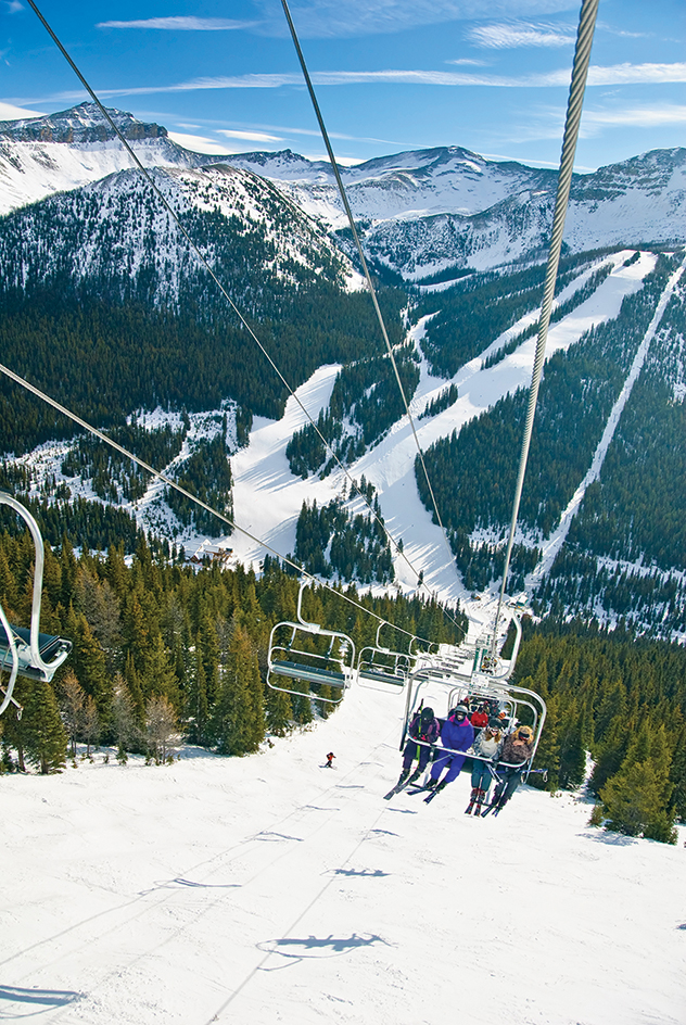
The Canadian Shield has much of Canada’s mineral wealth. The border between Quebec and Newfoundland and Labrador has huge deposits of iron ore. Deposits of cobalt, copper, gold, nickel, and uranium are mined near Greater Sudbury, Ontario a major smelting center. The Canadian Shield also contains valuable deposits of platinum, silver, zinc, and other metals.
The Hudson Bay Lowlands
form a flat, swampy region between the Canadian Shield and the southwestern coast of Hudson Bay. The lowlands extend about 800 miles (1,300 kilometers) from the Churchill River in Manitoba to the Nottaway River in Quebec. Stunted forests and decayed vegetable matter called peat cover much of the area. The only permanent settlements are several small villages, a few old trading posts and forts, and the ports of Churchill, Manitoba, and Moosonee, Ontario. 
The St. Lawrence Lowlands
make up the smallest Canadian land region, but more than half of the nation’s people live there. This region includes the flat-to-rolling countryside along the St. Lawrence River and the peninsula of southern Ontario. Another part of the region, Anticosti Island at the mouth of the St. Lawrence, remains a wilderness because of its isolation and colder climate. Southern Ontario has Canada’s only major deciduous forests, which consist of trees that shed their leaves every autumn. The most plentiful trees in these forests include beeches, hickories, maples, oaks, and walnuts. Foxes, rabbits, raccoons, squirrels, and other small animals inhabit the forests.
The St. Lawrence Lowlands have excellent transportation facilities and lie near markets in the eastern and central United States. These features help make the region the manufacturing center of Canada. Fertile soil and a mild climate enable farmers in the St. Lawrence Lowlands to produce about a third of Canada’s agricultural output. The most important crops include barley, corn, oats, soybeans, and a variety of fruits and vegetables. The region also has a large number of dairy farms.
The Appalachian Region
includes southeastern Quebec and all of the Atlantic Canada region except Labrador. The region forms part of an ancient mountain chain extending from the island of Newfoundland south to Alabama. The terrain of the Appalachian Region generally is hilly. The effects of glaciers and erosion have rounded the mountains. The Shickshock Mountains on the Gaspé Peninsula of Quebec have the region’s highest peaks, which reach just over 4,000 feet (1,220 meters). 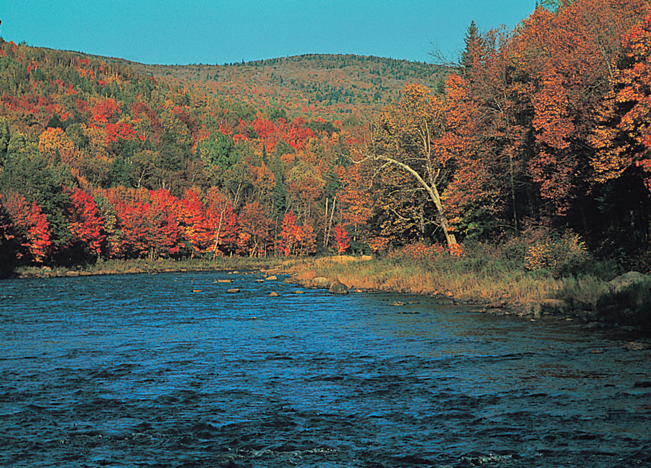
Most residents of the Appalachian Region live along the coast, where hundreds of bays and inlets provide harbors for fishing fleets. In most areas, the land rises gradually from the Atlantic Ocean. Parts of Nova Scotia and the island of Newfoundland, however, have steep, rocky coasts. The Bay of Fundy, between New Brunswick and Nova Scotia, is famous for its high tides, which reach more than 50 feet (15 meters) in some areas.
Mixed evergreen and deciduous forests cover much of the Appalachian Region. Valuable farmland lies on the plains of Prince Edward Island and along the Saint John River in New Brunswick and the Annapolis River in Nova Scotia. Nova Scotia has important coal and gypsum resources. Copper, lead, zinc, and other minerals are mined in New Brunswick and on Newfoundland.
Rivers, waterfalls, and lakes
add to the scenic beauty of the Canadian countryside. Until the first railroads were built during the 1800’s, the rivers and lakes also provided the only means of reaching Canada’s vast interior. Many of these waterways still serve as major transportation routes. They also have economic importance as sources of hydroelectric power and, in the western provinces, for irrigation. 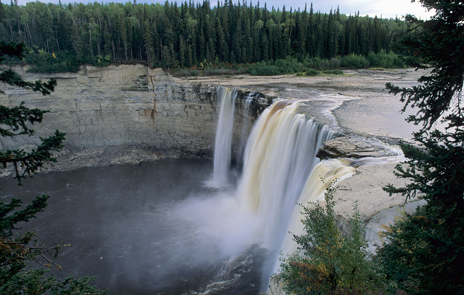
The water from each of Canada’s lakes and rivers eventually drains into one of four major bodies of water. Therefore, the country has four major drainage areas, or basins—the Atlantic Basin, the Hudson Bay and Hudson Strait Basin, the Arctic Basin, and the Pacific Basin.
The Atlantic Basin
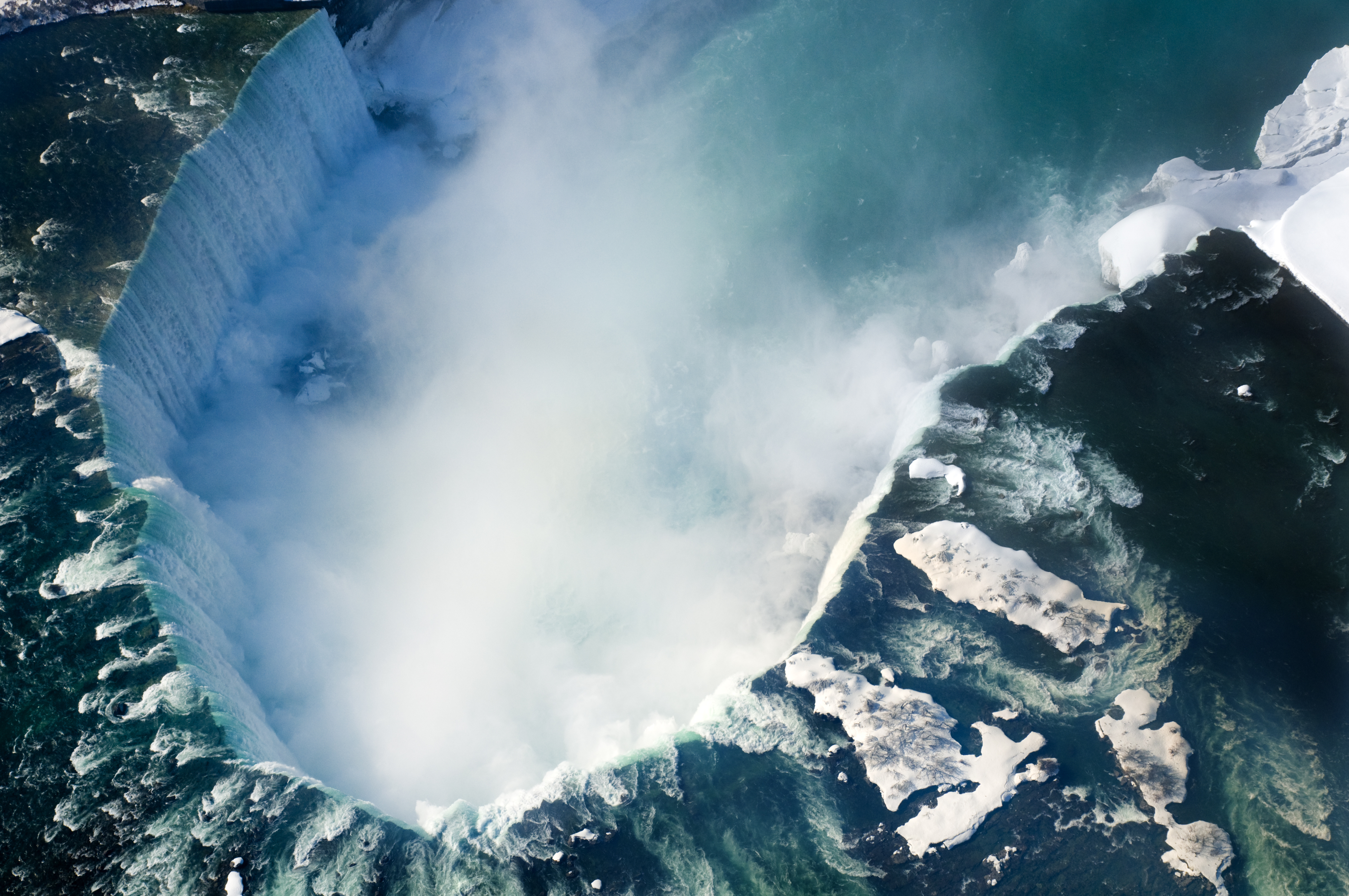
covers about 678,000 square miles (1,756,000 square kilometers) in eastern Canada. The most important waterway in this drainage area is the Great Lakes-St. Lawrence River system. The Great Lakes, the largest group of freshwater lakes in the world, cover 94,230 square miles (244,060 square kilometers). Lake Michigan lies entirely within the United States, but the border between Canada and the United States passes through the other four Great Lakes and the rivers that connect them. These rivers are the Saint Marys, the Detroit, the St. Clair, and the Niagara. Between Lake Erie and Lake Ontario, the Niagara River plunges over a rocky ledge and forms Niagara Falls, a world-famous tourist attraction.
The St. Lawrence River flows about 800 miles (1,300 kilometers) from Lake Ontario to the Gulf of St. Lawrence, an arm of the Atlantic Ocean. The St. Lawrence is sometimes called the Mother of Canada because it was the chief route of the European explorers, fur traders, and colonists who came to Canada several hundred years ago. Today, the St. Lawrence forms part of the St. Lawrence Seaway and carries more freight than any other Canadian river. The St. Lawrence Seaway enables oceangoing ships to travel between the Atlantic and such Great Lakes ports as Toronto and Chicago. The Thousand Islands, which lie in the St. Lawrence River near Lake Ontario, are a popular resort area.
Dams on the major tributaries (streams that flow into a larger stream) of the St. Lawrence provide much hydroelectric power for Quebec. Generating stations have been built on the Ottawa, Bersimis, Outardes, and Manicouagan rivers. Many other rivers have the potential for hydroelectric power. Such tributaries as the Ottawa, the St. Maurice, and the Saguenay are important to loggers, who float wood to pulp and paper plants downstream.
The Montmorency River plunges 251 feet (77 meters) near Quebec City to form Montmorency Falls. Churchill Falls, on the Churchill River in Labrador, is the site of one of the largest hydroelectric generating stations in the Western Hemisphere. New Brunswick is famous for the Reversing Falls at the mouth of the Saint John River. Twice each day, high tides from the Bay of Fundy force the river backward through the falls.
The Hudson Bay and Hudson Strait Basin
covers about a third of mainland Canada. The chief river in this basin is the Nelson, which flows from Lake Winnipeg to Hudson Bay. During the 1700’s and 1800’s, the Nelson served as an important transportation route for the Hudson’s Bay Company, a British fur-trading company. Today, the river serves mainly as a source of hydroelectric power. The Nelson’s principal tributaries—the Assiniboine, the North and South Saskatchewan, the Red, and the Winnipeg rivers—flow into Lake Winnipeg rather than directly into the Nelson. The headwaters of the South Saskatchewan provide water for irrigating dry farmlands in southern Alberta. Hydroelectric generating stations on the Winnipeg River supply some electric power for the city of Winnipeg.
Other major rivers that flow into Hudson Bay include the Churchill and Hayes in Manitoba, the Severn and Winisk in Ontario, and the Thelon in the Northwest Territories and Nunavut. Several rivers empty into James Bay. Among them are the Albany and Moose in Ontario; and the Eastmain, Nottaway, and Rupert in Quebec. La Grande River has four large hydroelectric generating stations. Together these stations form one of the world’s most important power projects.
The Arctic Basin
includes parts of British Columbia, the Prairies, and the territories. The Mackenzie River system drains about half the basin. The sources of this river system, Canada’s longest, are high in the Rocky Mountains, where the Peace and Athabasca rivers begin. These two rivers flow into the Slave River, which in turn empties into Great Slave Lake. The Mackenzie River itself flows northwest from Great Slave Lake for 1,100 miles (1,770 kilometers) to the Arctic Ocean. Along the way, the Mackenzie River receives water from many tributaries, the largest of which is the Liard River. The Great Bear River flows into the Mackenzie from Great Bear Lake, the largest lake that lies entirely in Canada.
Barges carry cargo over much of the Mackenzie River system. The main route extends for 1,122 miles (1,805 kilometers) between the Northwest Territories towns of Tuktoyaktuk on the Arctic Ocean and Hay River on Great Slave Lake. Barges that provide service to local settlements navigate some stretches of the Slave and Athabasca rivers.
The Pacific Basin
covers much of British Columbia and Yukon. The Yukon River drains the northern third of the region. This river rises from a series of lakes in northwest British Columbia and flows west through Yukon and Alaska to the Pacific Ocean. During the gold rush of the 1890’s, riverboats brought thousands of prospectors up the river to Dawson, a boom town near the Klondike gold fields.
The longest river in the southern part of the Pacific Basin is the Fraser. It flows through a deep valley from the Canadian Rockies to Vancouver, where it empties into the Pacific. The Columbia River rises in the mountains of southeastern British Columbia and flows south into the United States. Hydroelectric plants operate at several points on the Columbia. The Columbia goes through Upper Arrow Lake and Lower Arrow Lake, two long, narrow lakes in the interior valleys. Other important rivers of the Pacific Basin include the Kootenay, Skeena, Stikine, and Thompson.
Climate
Canada’s northern location gives it a generally cold climate, but conditions vary from region to region. In the winter, westerly winds bring frigid Arctic air to most of Canada. Average January temperatures are below 0 °F (–18 °C) in more than two-thirds of Canada. January temperatures average above freezing only along the coast of British Columbia. This area has a moderate climate because of mild winds from the Pacific Ocean.
Northern Canada has short, cool summers. In the northern Arctic Islands, July temperatures average below 40 °F (4 °C). Permanent icecaps cover parts of Baffin, Devon, and Ellesmere islands. Southern Canada has summers that are long enough and warm enough for raising crops. Summer winds from the Gulf of Mexico often bring hot weather to southern Ontario and the St. Lawrence River Valley. Southern Ontario has average July temperatures above 70 °F (21 °C) and a frost-free growing season nearly six months long.
Some coastal areas of British Columbia receive more than 100 inches (250 centimeters) of precipitation annually. Most of it falls in autumn and winter. The Canadian prairies have from 10 to 20 inches (25 to 50 centimeters) of precipitation a year. Little snow falls there, and most of the rain comes during the summer. These conditions help make the prairies ideal for growing grain.
Southeastern Canada has a humid climate. The average annual precipitation ranges from about 30 inches (76 centimeters) in southern Ontario to about 60 inches (150 centimeters) on the coasts of Newfoundland and Labrador and Nova Scotia. Heavy snow covers eastern Canada in winter. More than 100 inches (250 centimeters) of snow falls annually on large areas of New Brunswick, Newfoundland and Labrador, Quebec, and Ontario.
Economy
In colonial times, most Canadians earned a living by farming, fishing, logging, or fur trapping. Today, the main economic activities in Canada are service industries and manufacturing. Canada’s gross domestic product (GDP)—the total value of goods and services produced within a country in a year—is among the largest in the world.
The Canadian economy is based on private enterprise. But the national and provincial governments play an active role in many economic activities. For example, they provide free health services to all Canadians. The federal and provincial governments also own broadcasting companies, transportation firms, and utilities.
Foreign investment and ownership—especially from the United States—have a major influence on Canada’s economy. Japan and countries of the European Union also have large investments in Canada. A free trade agreement with the United States went into effect in 1989. The agreement called for the elimination of all tariffs (taxes on imports) between the two countries. In 1994, Canada joined with the United States and Mexico in the North American Free Trade Agreement (NAFTA), which built upon the previous pact between Canada and the United States. Another regional trade agreement replaced NAFTA in 2020. In Canada, it was called the Canada-United States-Mexico Agreement (CUSMA).
Service industries
account for the largest portion of Canada’s GDP. They are especially important in metropolitan areas. Community, business, and personal services rank first among Canada’s service industries. This group employs more people than any other industry group in Canada. It includes such activities as education and health care, data processing and legal services, and the operation of recreational facilities.
Finance, insurance, and real estate form the second most important service industry in terms of GDP. Toronto and Montreal are Canada’s leading financial centers. The main Canadian stock exchange is in Toronto.
Other service industries include government; trade, restaurants, and hotels; and transportation and communication. Government services, which include military activities, are centered in Ottawa, the nation’s capital, and in the provincial capitals and major cities. Restaurants and hotels benefit from the millions of people who visit Canada each year. Retail trade, which consists of such businesses as automobile dealerships, department stores, and supermarkets, employs many people.
Manufacturing.
Factories in Ontario and Quebec produce about 70 percent of the value of Canada’s manufactured goods. In terms of value added by manufacture, transportation equipment and processed foods and beverages rank as the nation’s leading manufactured products. Value added by manufacture is the difference between the value of raw materials and the value of finished products made from them. The manufacture of motor vehicles and parts dominates the transportation equipment industry. Most of Canada’s automobile manufacturing takes place in southern Ontario. Aircraft and aerospace equipment production is a fast-growing part of the manufacturing industry. Bombardier Aerospace in Quebec is one of the world’s largest civil aircraft manufacturers.

Processed food and beverage products is a leading manufacturing industry in every province. Processed meat and poultry are the leading products of Canada’s food and beverage industry. Toronto is a major meat-packing center. Other leading products include baked goods, beer, dairy products, fruit and vegetable products, and soft drinks. Seafood production is important in Atlantic Canada.
Much of Canada’s manufacturing is dedicated to processing its forest and mined products. Canada’s forests are used for manufacturing paper and wood products. Most provinces have at least one oil refinery, and Canada is one of the world’s leading oil refiners. 

Other important manufacturing industries in Canada produce chemicals, machinery, and primary metals. Most chemical production occurs in Alberta, Ontario, and Quebec. Pharmaceuticals (medicinal drugs) are the leading chemical product. Much of the machinery is used in agriculture and mining. Canada’s smelters and refineries produce basic aluminum and steel products. Quebec leads in aluminum production. Ontario makes the most steel.
Mining.
Canada is among the major producers of a variety of minerals, including copper, gold, iron ore, nickel, potash, uranium, and zinc. The country is also one of the world’s leading exporters of minerals.
Canada’s two most important mined products are petroleum and natural gas. Alberta is the leading producer of petroleum and natural gas in Canada. Processing Alberta’s natural gas produces valuable amounts of sulfur as a by-product. Saskatchewan is a major source of uranium and potash.
Ontario and Quebec are Canada’s leading producers of metal ores. Much of the world’s nickel comes from Ontario. Ontario also mines large amounts of gold and copper, as does British Columbia. Quebec produces iron ore and gold. Newfoundland and Labrador produces copper, iron ore, and nickel. New Brunswick is a leading zinc-mining province. Canada’s other mined products include coal, diamonds, platinum, salt, sand and gravel, silver, and stone.
Agriculture.
Farmland covers about 6 percent of Canada’s land area. Beef cattle, canola, dairy products, hogs, and wheat combine to account for over half of the total farm income. Other leading products include chickens, corn, eggs, floriculture (ornamental plants) and nursery products, and soybeans.
About 80 percent of Canada’s farmland lies in the Prairies. Saskatchewan produces nearly half of Canada’s wheat, and Alberta, Manitoba, and Ontario raise most of the rest. Barley, canola, flaxseed, and oats grow in a belt north of Canada’s wheat-growing areas. Farmers use barley and oats mainly for livestock feed. Canola and flaxseed are used to make cooking oils and lubricants. Farms in Alberta produce about half of the nation’s beef cattle. Farmers in the Prairies also raise dairy cattle, hogs, and poultry. 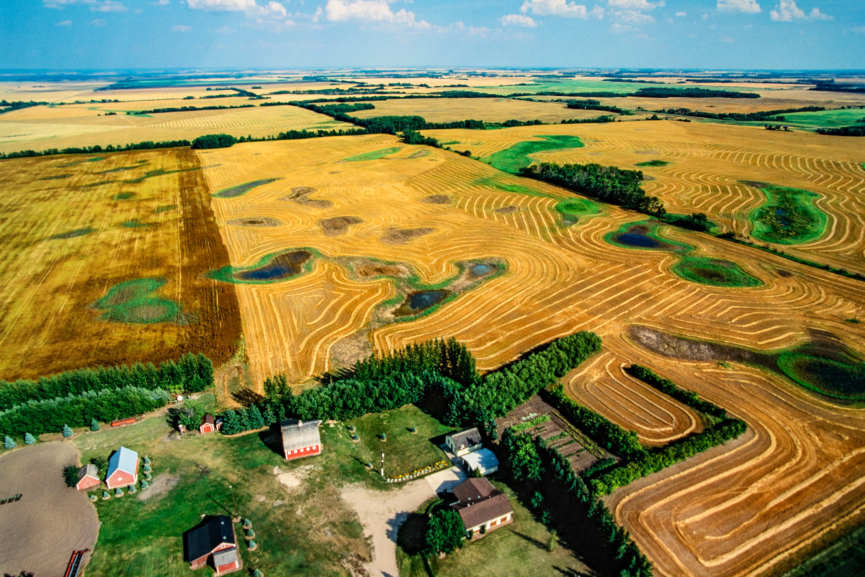
The St. Lawrence Lowlands form Canada’s other major agricultural region. Farmers there produce a variety of products, including beef cattle, grains, milk, and vegetables. Southern Ontario’s warm summers and long growing season enable farmers to grow a variety of specialty crops, including corn, fruits, tobacco, and vegetables. Quebec leads the provinces in the production of milk, and Ontario ranks second. Quebec’s farmers also raise beef cattle, corn, hogs, and poultry.
Farms in the interior of British Columbia and Vancouver Island produce eggs, milk, poultry, and tree fruits. British Columbia and Ontario are Canada’s leading growers of nursery products and ornamental plants and flowers. Potato farming and dairying are the chief agricultural activities in Atlantic Canada.
Government marketing agencies establish production quotas and price supports to protect Canadian farmers from the effects of changing prices. The federal and provincial governments also provide credit, as well as technical and management assistance, to farmers. In many areas, farmers have formed cooperatives. These organizations market the farmers’ products and supply goods and services needed in farming.
Forestry.
Canada is a leading timber-producing nation. The federal and provincial governments own most of the forests and lease them to private companies. British Columbia and Quebec lead the provinces in timber production. Loggers cut down cedars, firs, hemlocks, pines, spruce, and many other kinds of trees. Mills process the logs into lumber, paper, plywood, and wood pulp. 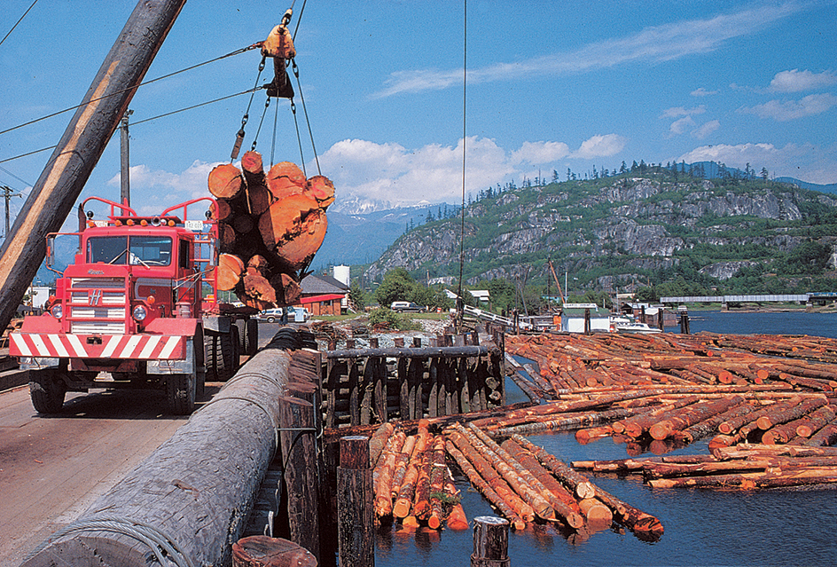
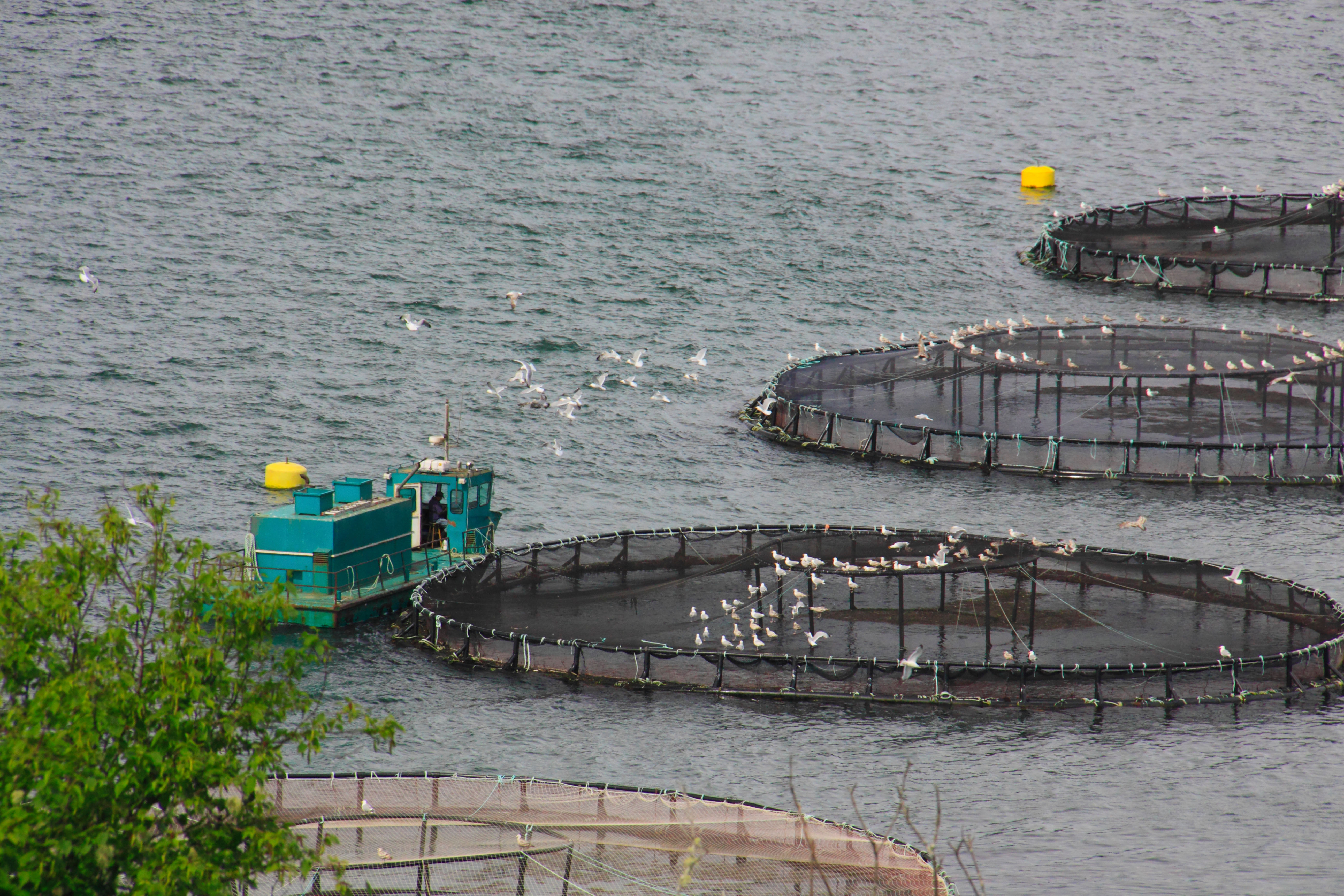
Fishing
is Canada’s oldest economic activity. The Grand Banks, off the coast of Newfoundland, began to attract European fishing crews in large numbers during the 1500’s. Today, the major products of Canada’s Atlantic waters include clams, crabs, Greenland turbot, halibut, lobsters, scallops, and shrimp. Cod were once plentiful in the Atlantic coastal waters, but they have nearly disappeared due to overfishing. The population of certain other fish has also declined. As a result, the government has banned almost all cod fishing and placed restrictions on other fishing in Canada’s Atlantic waters. 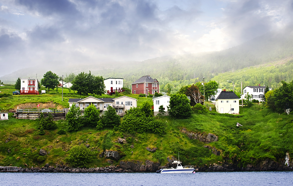
Fishing crews take halibut, salmon, and shellfish from Canada’s Pacific waters. They catch most of the salmon near the mouths of major rivers in British Columbia. However, the salmon fishing industry is in danger. Salmon stocks have fallen due to overfishing by crews from British Columbia, Alaska and Washington in the United States, and other countries. In 1998, the Canadian government ordered a halt to fishing for some types of salmon. Today, British Columbia has a large number of fish farms that raise salmon.
Canada’s lakes provide fish chiefly for the central part of the country and the United States. The principal lake fish include perch, pickerel, and whitefish.
Energy sources.
Canada has a high per-person rate of energy use. Huge quantities of energy are needed to provide heat during severe winters. Much energy is also needed to transport goods and people between distant regions and to process natural resources. Canada has vast energy resources, but most Canadians consider energy conservation as essential. Conservation helps slow the depletion of nonrenewable energy sources, such as petroleum and natural gas. Reducing fuel consumption through conservation also lessens the amount of pollution released into the environment.
Much of the petroleum used in Canada takes the form of gasoline. More than half of Canada’s electric power comes from hydroelectric sources. Plants powered by natural gas, oil, or coal provide about a fifth of Canada’s electric power. Other power sources include nuclear energy and renewable sources, such as wind or biomass (organic material used for fuel).
International trade.
Canada ranks among the leading countries in the world in international trade. The nation’s exports total hundreds of billions of dollars annually. About half of Canada’s imports come from the United States, and about three-fourths of its exports go to the United States. Both countries export and import automobiles and automobile parts and various kinds of machinery.
Canada’s other leading exports include forest products, precious metals and metal ores, natural gas, petroleum, and wheat. Canada’s other major imports include crude oil, pharmaceuticals, and scientific instruments. Canada’s chief trading partners, besides the United States, include China, Germany, Japan, Mexico, South Korea, and the United Kingdom.
Transportation.
Canada’s landscape has many features that create barriers to travel, including mountains, forests, and bodies of water. In spite of these barriers, Canadians have built an outstanding system of railroad, highway, water, and air transportation.
Railroads.
Canada’s railroad system has about 31,000 miles (49,000 kilometers) of mainline track. The two main railroads are the Canadian National Railway (CN) and the Canadian Pacific Railway. Both are privately owned. The government-owned corporation VIA Rail Canada provides the only trans-Canada passenger rail service. Other passenger rail services operate within some provinces. Commuter systems serve some urban areas.
Toronto and Montreal have modern subway systems. Calgary, Edmonton, Ottawa, and Vancouver have light rail transit systems, which use electrically powered cars that run on tracks.
Roads and highways.
Southern Canada has one of the world’s finest highway systems. The Trans-Canada Highway extends about 5,000 miles (8,000 kilometers) between Victoria, British Columbia, and St. John’s, Newfoundland and Labrador. Northern Canada has few highways. Many roads there are unpaved.
Ferries link roads on Vancouver Island and Newfoundland with roads on other islands and on mainland Canada. Confederation Bridge joins Prince Edward Island to New Brunswick. Buses provide public transportation in Canadian cities. Buses also link cities with outlying towns and other cities.
Waterways and ports.
The Great Lakes and the St. Lawrence Seaway form one of the world’s greatest inland waterways. The seaway enables oceangoing ships to sail between the Atlantic Ocean and Great Lakes ports. These ships transport iron ore, petroleum, wheat, and other bulk cargoes. Vessels called lakers transport cargo between ports on the Great Lakes and the St. Lawrence River. For example, lakers carry iron ore from ports on the St. Lawrence to steel mills on the Great Lakes. 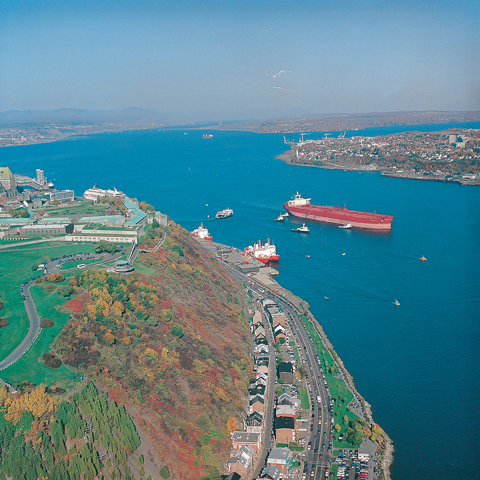
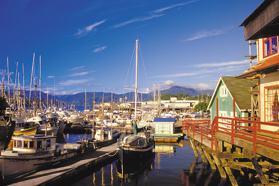
The port of Vancouver, including the facilities at nearby Roberts Bank, is Canada’s busiest port. Prince Rupert, British Columbia, is also an important Pacific port. Major ports on the St. Lawrence River include Montreal, Port-Cartier, Quebec City, and Sept-Îles in Quebec. The main Great Lakes ports include Hamilton and Thunder Bay in Ontario. Canada’s busiest Atlantic Ocean ports include Come By Chance, Newfoundland and Labrador; Halifax and Port Hawkesbury in Nova Scotia; and Saint John, New Brunswick.
Air travel.
Air Canada is Canada’s largest airline. It provides both domestic and international service. WestJet provides service mainly in western Canada, but it also serves several eastern cities. Toronto Pearson International Airport is Canada’s busiest airport, followed by Vancouver International Airport.
Communication
plays a vital role in linking different parts of a nation as vast as Canada. Canadians rely on a variety of communication systems, including telephone and Internet service, television and radio, mail service, and publishing.
Telephone and Internet service.
Various telecommunications companies provide telephone and Internet service throughout Canada. Deregulation of the industry in the 1990’s led to increased competition and mergers among telephone service providers.
Bell Canada Enterprises is Canada’s largest communications company. It provides phone, internet, satellite television, and other services to many homes and businesses. Cable and satellites link Canada’s telecommunications systems to those of most other countries.
Television and radio.
The Canadian Broadcasting Corporation/Radio-Canada (CBC/Radio-Canada) operates national television and radio networks in both English and French. The corporation is financed largely by the government, but it functions independently in its programming. Canada’s satellite communications system enables CBC/Radio-Canada broadcasts to reach most of the population. Canada’s other national TV networks are CTV Television Network and Global Television Network, which are privately owned. Commercial networks serve all major metropolitan areas. Many of the nation’s households subscribe to cable TV systems, which offer a variety of Canadian and U.S. programs. 
The Canadian Radio-television and Telecommunications Commission (CRTC), a government agency, regulates electronic communication systems in Canada. The CRTC issues licenses to radio and television stations and makes sure that certain percentages of their programs have Canadian content. These Canadian-content quotas are intended to help maintain a Canadian cultural identity in the face of overwhelming U.S. influence. They also create jobs in Canada by encouraging the production of TV and radio shows.
Publishing.
Canada has a variety of daily newspapers printed in both English and French. The leading English-language dailies include the Toronto Star, The Globe and Mail, the National Post, and the Toronto Sun of Toronto; The Vancouver Sun of Vancouver; The Gazette of Montreal; and the Ottawa Citizen. The leading French-language dailies are Le Journal de Montréal and La Presse of Montreal. Many weekly and biweekly newspapers are also published in Canada.
Publishers in Canada produce a number of magazines. The best known include the news magazines Maclean’s in English and L’Actualité in French. The women’s magazine Chatelaine (Châtelaine in French) has both an English-language version and a French-language version. Magazines from the United States also have a wide audience in Canada, and magazines from France have many readers in Quebec. Ontario and Quebec are the leading book publishing provinces. Many U.S., British, and French publications are printed in Canada at the same time as in their own country.
