Central Region is an area of Scotland that lies between the Highlands and the Central Lowlands. The region’s position, on the narrow “waist” of Scotland, has made it an important area in Scottish history. Stirling Castle, in the region, has dominated the main invasion route from England to the north for centuries.
In 1975, Central Region was made into a division of Scotland’s local government. The region was abolished in 1996 and divided into three council areas: Clackmannanshire, Falkirk, and Stirling. A council area is a governmental unit responsible for all local government services within its boundaries. See Clackmannanshire ; Falkirk ; and Stirling .
People and government
Most of the region’s people live in the industrial towns of the low-lying eastern parts.
Local customs.
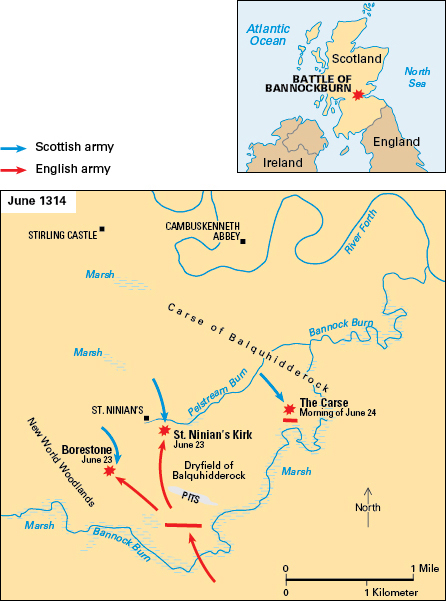
An important annual event is the celebration of the anniversary of the Battle of Bannockburn (1314), when the Scots defeated the English. People march to the battlefield, near Stirling, on the Saturday nearest June 24. See Bannockburn, Battle of .
Recreation.
Association football (soccer) is the most popular sport in the region. Rugby, golf, and field hockey are also popular. Shooting and fishing are important in the north and west.
Economy
Manufacturing.
The area between Bonnybridge, Denny, and Falkirk has a long tradition of iron manufacture. In Clackmannan, the important industries are textile production, brewing, and whisky distilling.
Grangemouth is Scotland’s largest oil-importing port. Pipelines carry oil to Grangemouth from Finnart on the mouth of the River Clyde in western Scotland. A huge refinery in Grangemouth produces various fuel oils and raw materials for the local petrochemicals industry. Using the refinery output, Grangemouth petrochemical companies produce materials for synthetic fibers and for plastics.
Agriculture
varies widely in Central Region. In the northern and western areas, the thin, poor soil makes the land suitable only for sheep farming. In eastern areas, particularly in the lowlands near Stirling, the heavy, clay soils are used for crop farming. The main crops are oats and grass. Forestry is important in some parts of the region.
Mining and quarrying.
Central Region is part of the Central Scotland coal field. This field extends from a point near the west coast to the east coast in Fife Region. But coal production in Central Region declined during the late 1900’s. Quarries produce sand, sandstone, and gravel.
Tourism
is of economic importance in Central Region. Major tourist centers are Callander, Dunblane, Stirling, and the Trossachs area in the north.
Transportation and communication.
Railroad lines link Falkirk and Stirling with Edinburgh and Glasgow. Falkirk and Stirling are the principal centers for buses.
The River Forth creates a barrier across the middle of the region. Most of the main roads linking northern and southern parts cross the Forth near Stirling.
Local weekly newspapers are published in Alloa, Falkirk, Grangemouth, and Stirling.
Land
Location and size.
Central Region is an entirely inland area. It is bordered by Tayside Region to the north and northeast and by Strathclyde Region to the west and south. Central Region has short boundaries in the east both with Fife Region and with Lothian Region.
The region covers only 3 percent of the total area of Scotland. Its maximum distance from east to west is about 41 miles (66 kilometers) and from north to south is about 40 miles (64 kilometers).
Land features.
The northern area in Central Region is part of the Scottish Highlands. Seven mountains in this area reach more than 3,000 feet (900 meters).
At the southern edge of the Highlands is the Highland Boundary Fault, which runs across the middle of Central Region. The lowlands area to the south is broken by volcanic hills rising to more than 980 feet (300 meters).
The River Forth drains almost all of the Central Region. In the north, lochs (lakes) Katrine, Achray, and Vennachar almost divide the region in half. The lochs are drained by the River Teith, the main tributary of the River Forth. Loch Katrine is the largest of the three lochs on the Teith. It is the main source of water for Glasgow in neighboring Strathclyde Region.
Climate.
Annual rainfall and temperatures resemble those of other parts of Scotland. The average annual rainfall varies from 90 inches (229 centimeters) in the west of the region to less than 30 inches (76 centimeters) in the east.
The average January temperature is 37 °F (3 °C), and the average July temperature is 57 °F (14 °C).
History
The region’s strategic position has given it a leading part in Scottish history. The Romans built a major fortification in the area—the Antonine Wall.
During the 1200’s and 1300’s, there was much fighting in Central Region between Scotland and England. Sir William Wallace won a battle against the English at Stirling Bridge and later lost one near Falkirk. The most important battle of this period was Bannockburn, in 1314. Robert Bruce’s strategy led to victory for the outnumbered soldiers and to Scotland’s independence.

During the first Jacobite Rising in 1715, supporters of James Edward Stuart were defeated at the Battle of Sherriffmuir, near Dunblane. Charles Edward Stuart (also known as Bonnie Prince Charlie) fought the pursuing English at Falkirk during the second Jacobite Rising. The folk hero Rob Roy lived at Balquhidder, near Lochearnhead.
The region’s economy developed rapidly during the Industrial Revolution, a period of rapid industrialization that began in the 1700s, because of local deposits of iron ore and coal. Shipbuilding also became important.
In 1996, 16 children and one teacher died in a mass shooting at a primary school in Dunblane. The tragedy led to the Firearms Amendment of 1997 banning private handgun ownership in the United Kingdom.
