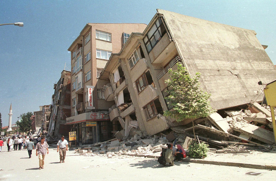
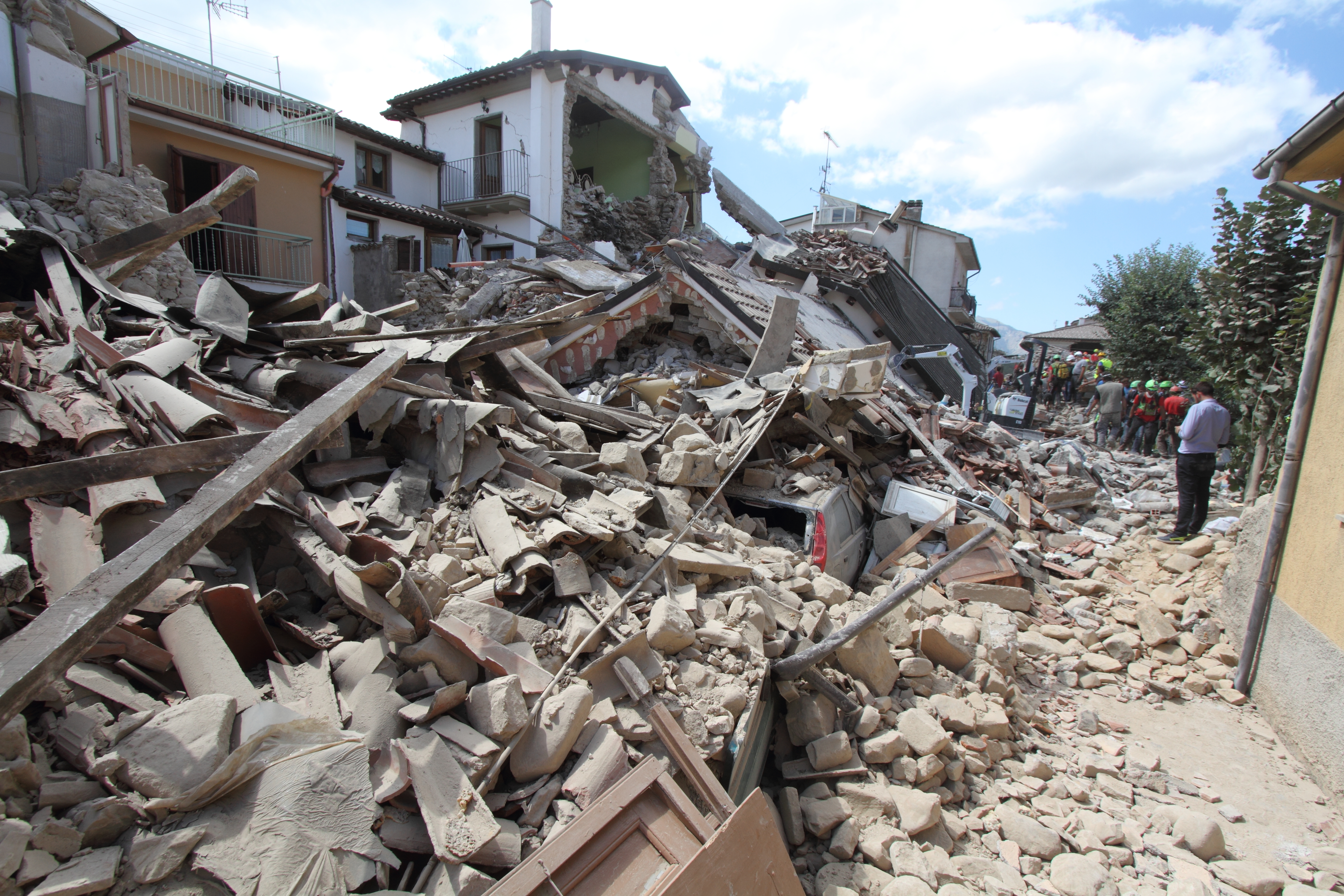
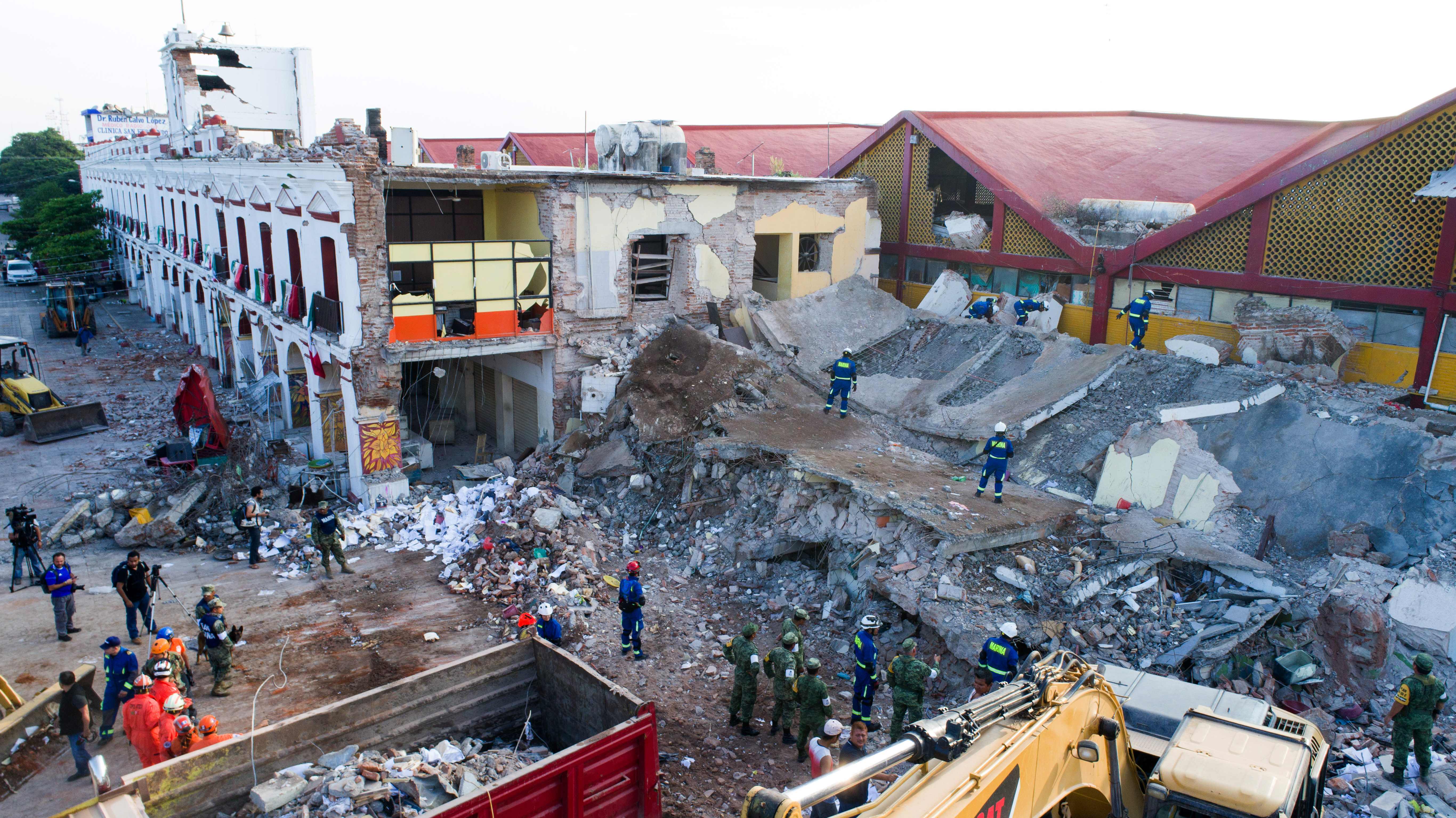
Earthquake is a shaking of the ground caused by a sudden shift in Earth’s rocky outer shell. Earthquakes rank among the most powerful events on Earth. A severe earthquake may release 10,000 times as much energy as did the first atomic bomb. The results can be terrifying. The shaking can damage buildings, bridges, and other structures so badly that they fall down. Earthquakes can also cause avalanches and landslides on land. In the ocean, quakes can cause a series of huge, destructive waves called a tsunami << tsoo NAH mee >> . After a quake, broken gas or power lines may cause fires. All of these effects can cause the loss of human life.
The force of an earthquake depends on how much the ground shifts. Powerful earthquakes can jolt firm ground violently for great distances. During minor earthquakes, the shaking may be no greater than that caused by a passing truck. Earthquakes can occur just below Earth’s surface or at depths down to about 435 miles (700 kilometers) underground.
Scientists think that several million earthquakes occur every year. On average, only about 150,000 of them are strong enough to be felt by humans. Of those, about 15,000 quakes are strong enough to cause significant property damage and about 150 are strong enough to cause significant loss of life.
Scientists monitor quakes using instruments called seismometers. These instruments record the displacement (change in position) of the ground or a structure. Scientists cannot predict the exact time, place, and magnitude (strength) of an earthquake. However, they can often make forecasts about the likelihood of a strong quake for regions with well-known earthquake histories.
Quakes also occur beyond Earth. Scientists have recorded quakes on the moonand on Mars. They think that quakes have also taken place on other moons and planets in our solar system.
Dangers from earthquakes
Earthquakes almost never kill people directly. Instead, they cause death or injury through falling objects and the collapse of buildings, bridges, and other structures.
Earthquake damage results from the shaking and cracking of ground. Shaking can damage or destroy structures. It can also cause landslides and avalanches. The cracking of ground can break gas and water lines. If the quake displaces the ocean floor up or down, it can produce a tsunami. Hazardous chemical spills may also occur during a quake.

Collapsing buildings
cause a large proportion of quake injuries and deaths. Even the most powerful earthquake poses little threat on open ground. However, the shaking can make buildings so unstable that they collapse, injuring, killing, or trapping the people inside.
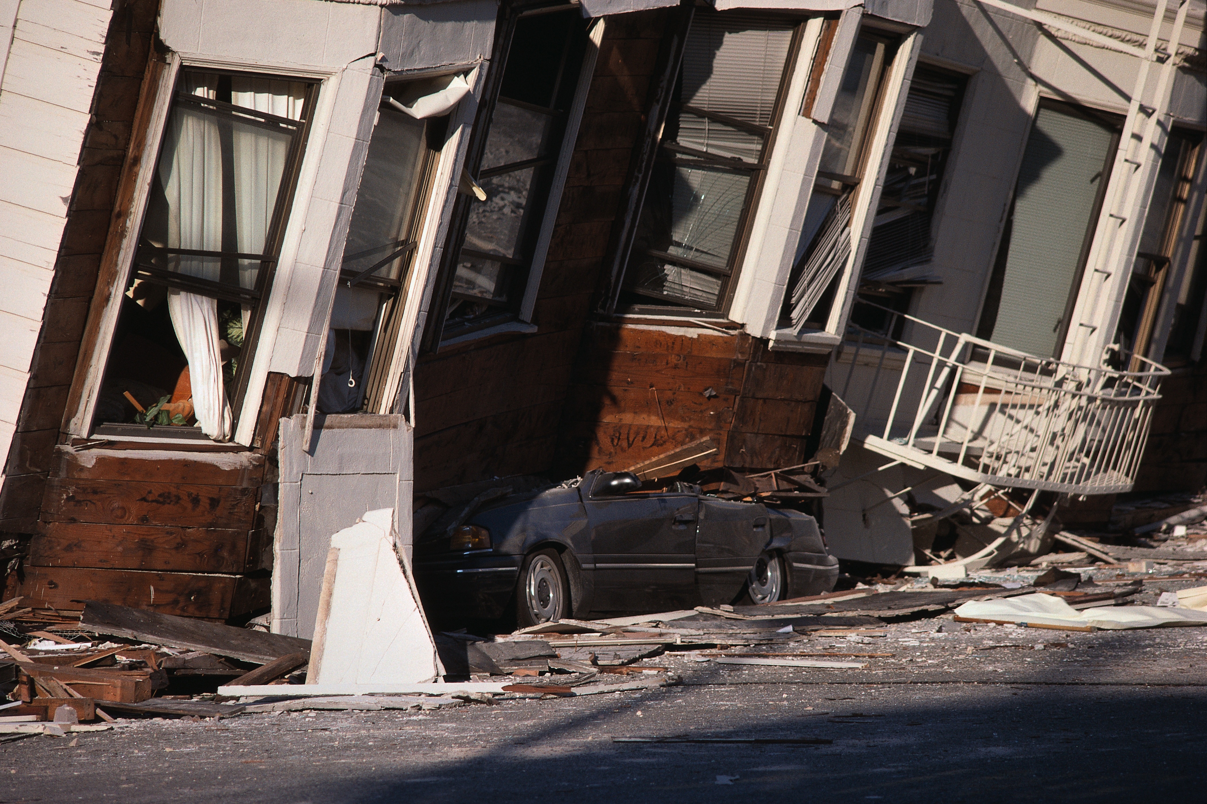
Earthquakes can also cause soft soil to act temporarily like a liquid, rather than a solid. This effect is called liquefaction. Anything on top of liquefied soil may sink into the soft ground. This soil may also flow toward lower ground, burying anything in its path. If liquefaction occurs under a building, the building can topple over.
The cracking of ground
in an earthquake can range from minor cracks to large, deep gashes several feet or meters wide. Most earthquakes occur along a fault. A fault is a fracture in Earth’s rocky outer shell where sections of rock slide past each other. In some cases, one side of the fault can move many feet or meters relative to the other side. Any structures that cross the cracked region—such as bridges, pipelines, power lines, houses, or fences—may be wrenched apart. Cracks in the ground may occur near the fault or in regions of soft sediment farther away.
Tsunamis
often occur when an underwater earthquake ruptures a normal fault or a reverse fault, displacing the seafloor up or down. In a normal or reverse fault, the break in the rocks is more or less vertical. The rocks move up or down along it.
In another type of fault called a strike-slip fault, the fracture also extends straight down. However, the blocks of rock slide past each other horizontally. Strike-slip faults on the seafloor seldom cause tsunamis because the sideways motion does not displace the water.
Tsunamis seem small in the open ocean. But they gain height and strength as they enter shallower waters near land. Tsunamis can travel long distances. In 1700, an earthquake in the Pacific Northwest caused a tsunami that was measured in Japan. In 1868, an earthquake off the coast of Arica, Chile, caused a tsunami that reached 2 miles (3.2 kilometers) inland. A 2004 earthquake near the Indonesian island of Sumatra caused a tsunami that spread throughout the Indian Ocean. The tsunami caused death and destruction in coastal areas of Southeast Asia, South Asia, and East Africa.
Landslides or avalanches
can be triggered by earthquakes in regions of unstable ground. The 1970 Ancash earthquake in Peru occurred offshore. But it caused a large landslide of ice, mud, and rocks in the nearby Andes Mountains. The landslide buried many thousands of people in the surrounding area. An earthquake in 1958 caused a landslide on Lituya Bay, in Alaska. The landslide entered the water, producing a local tsunami that rushed 1,700 feet (520 meters) up a nearby mountain.
Fire
is another consequence of earthquakes in populated regions. Ruptured gas lines are a major fire threat. In addition, the shaking or cracking of the ground can break water pipelines, making it difficult to put out any resulting fires. Fires burning out of control can cause more damage than the original earthquake. For example, fires caused most of the destruction and death associated with the San Francisco earthquake of 1906.
Reducing earthquake damage
Engineers, architects, and city planners can reduce the damage caused by earthquakes through proper planning and building design. Government agencies can regulate land use near faults and enforce strict building codes in regions of hazard. Fixing or removing older structures whose design is not quake resistant can also reduce damage. People can make their homes safer by anchoring large objects, such as appliances and furniture, to the floor or wall. Installing automatic shutoff valves for gas lines is another precaution.
There are two key factors to consider when building in earthquake-prone regions: the design of the structure and its location. Concerns related to location include the type of soil or rock beneath the structure and whether the structure will span a fault. Safe design takes into account the types and frequencies of earthquakes that might occur in the region.
Building design
is a key factor in determining how well a structure will withstand earthquakes. Stone or brick buildings with no metal frame, such as adobe houses, can collapse even in small earthquakes. Single-story wood-frame houses are more flexible. They generally will remain standing even during strong shaking. Taller buildings with relatively open first stories—such as those with lower-level parking areas—can collapse more readily. In such buildings, all the energy from the shaking may concentrate at the base, causing the building to fall.
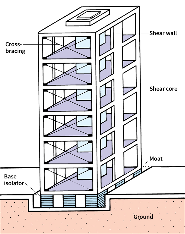
Certain structural elements can make steel-frame buildings more earthquake resistant. For example, shear walls might connect the columns. They are strong walls designed to resist the sideways force called shear, which causes much earthquake damage. Shear walls in the center of a building, such as those that surround stairwells and elevators, form what is called a shear core. Walls may also be reinforced with diagonal beams in a process called cross-bracing.
Tall buildings in regions with strong quakes are sometimes built on rollers or shock absorbers. This technique, called base isolation, enables the building to move independent of the ground, reducing the violence of shaking. Some modern base isolation systems include electronic motion sensors that adjust the strength of the shock absorbers. These adjustments allow the building to move only as much as the power of the earthquake demands.
Building location
affects earthquake safety. The type of ground that is being built upon can influence the choice of building methods. In addition, engineers and architects may avoid building on dirt or soil basins and landfills. Basins and landfills trap and intensify the shaking, making it go on for longer. In addition, soft sediments, such as former lakebeds and landfills, can liquefy during strong earthquakes.
It is best to avoid building structures across faults. Movement along a fault can crack the building foundation and possibly cause the building to collapse. In some areas, regulations forbid the construction of large buildings, such as schools, hospitals, or office buildings, close to an active fault. However, pipelines, roads, railroads, and water lines still must cross faults. In these cases, damage due to an earthquake can be reduced several ways. Pipelines can have flexible sections built along the pipe, so that the pipeline can adjust without breaking. Water lines can include an open basin or pond at the fault to catch the water in case of a break.
How an earthquake begins
Where a quake begins.
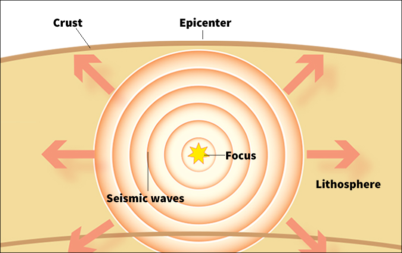
Earthquakes occur in Earth’s crust (outer layer) and upper mantle, the layer directly below the crust. In those two layers, the rocks are brittle enough to crack rapidly. Together, the crust and upper mantle make up the lithosphere. The lithosphere consists of a number of interlocking pieces called tectonic plates or lithospheric plates, similar to pieces in a jigsaw puzzle. The plates move slowly on an underlying layer of rock. The underlying layer is so hot it flows, even though it remains solid. The plates may move at rates of several inches or centimeters per year relative to each other. The theory of how these plates behave is called plate tectonics.
Most earthquakes occur at the boundaries where plates meet, also called faults. Many plate boundaries are vertical, and earthquakes happen along these faults down to about 20 to 25 miles (30 or 40 kilometers) in depth. Other boundaries lie at an angle, where the edge of one plate sinks and thrusts under the edge of another. This process is called subduction. Subduction zone faults start at the surface and may slope downward as deep as about 435 miles (700 kilometers).
The point deep within Earth where an earthquake originates is called the hypocenter or focus. Scientists identify the hypocenter by giving its latitude, longitude, and depth below the surface. The point on Earth’s surface directly above the hypocenter is the epicenter. The earthquake may take place entirely underground, or it may reach the surface.
Why a quake begins.
The inside of Earth is under enormous stress (pressure). The stress comes from the weight of the overlying rocks and the force of the tectonic plates moving. Even though plate motions are slow and constant, the plates do not always slide past one another easily. Instead, strain can build up along a fault, often for decades or centuries. When the stress becomes stronger than the rocks along the fault, the fault slips—that is, the rocks on either side suddenly snap into a new position. The snapping releases energy, much as a stretched rubber band releases energy when you let go of one end. When the energy is released, an earthquake results. Scientists then say that the fault has failed or slipped.
A slip can happen in just seconds. It can move along a fault at speeds of 1.8 miles (3 kilometers) per second.
The surface at which rocks grind against each other during an earthquake is called the fault plane. The grinding breaks many rocks to pieces. Stronger rocks in the fault plane, however, can resist more stress without breaking. Such strong rocks may stop the slipping.
The size of the slip area varies. In a small earthquake, the sides of the fault might slip less than 1/2 inch (1 centimeter) over an area of about 120 square yards (100 square meters). Only seismometers would notice such a slip. During a stronger earthquake, the sides of the fault might slip as much as 33 feet (10 meters). The fault plane might extend hundreds of miles or kilometers long and tens of miles or kilometers deep.
Not all fault motion produces large earthquakes. Some faults slip oftener or slower. The movements may last for weeks and can occur as frequently as every six months. They also involve less shifting of the rocks than major earthquakes do. Scientists describe such patterns as episodic tremor and slip or slow earthquakes.
Other processes outside of plate boundaries can occasionally cause earthquakes. If an area is volcanically active, excess pressure from magma (molten rock underground) can suddenly crack the lithosphere, causing an earthquake. The high pressure and temperature of underground volcanic activity may also cause a quake.
Scientists suspect human activities of triggering some earthquakes. The activities that may cause quakes include filling reservoirs, pumping water into drilled holes, and extracting fluids, such as petroleum or groundwater (water beneath the surface), from wells. Underground bomb explosions can trigger earthquakes in the area. Even collapses of underground mines can resemble small earthquakes.
How an earthquake spreads
When an earthquake strikes, the energy travels through Earth’s crust in waves of vibration called seismic waves. Seismic waves move out from the hypocenter in all directions. As the waves travel, they gradually weaken. For this reason, there is generally less shaking farther from the hypocenter.
There are two chief kinds of seismic waves, body waves and surface waves. Body waves, the fastest seismic waves, travel through the ground. Surface waves, which are slower, travel only on the surface of Earth.
Body waves
can cause significant earthquake damage. There are two types of body waves, pressure waves, also called compressional waves, primary waves or P waves, and shear waves, also called secondary waves or S waves. P waves cause particles in the ground to move back and forth in the direction that the wave is traveling. To picture a P wave, imagine a coiled metal spring. If you squeeze and then release a few coils at one end of the spring, the spring will expand and contract much as a P wave moves through the ground. S waves move the particles from side to side, in a direction perpendicular to the direction that the wave is traveling. To picture an S wave, imagine a rope lying on the ground. If you shake one end of the rope left and right, the rope will move in an S shape that travels along its length, much like an S wave.
P waves are also called primary waves because they are the fastest-moving body waves and the first to be detected. P waves travel at speeds ranging from about 1 to 5 miles (1.5 to 8 kilometers) per second in Earth’s crust. They move faster in the mantle. P waves can travel through both solid material and fluids.
S waves are also called secondary waves because they move more slowly, about 65 percent, than P waves and are thus detected after P waves. S waves can travel only through solids, not through fluids. If seismic waves encounter Earth’s liquid outer core or a magma chamber beneath a volcano, for example, only the P waves will pass through.
The time between arrivals of the P and S waves increases with distance from the hypocenter. Because P and S waves travel through the interior of Earth, they lose energy rapidly. P and S waves are refracted (bent) and reflected at boundaries between layers inside Earth. These boundaries include those between the crust and the mantle, between the mantle and the outer core, and between the outer core and the inner core. Boundaries between loose soil and dense rock in the crust may also affect a wave’s speed and movement.
Surface waves
are long, slow waves. They produce what people feel as slow rocking sensations and can cause significant damage to buildings.
There are two types of surface waves, Love waves and Rayleigh waves. Love waves move the ground from side to side. They generally travel about 2.8 miles (4.5 kilometers) per second. Rayleigh waves move the ground up, backward, down, then forward in a rolling motion. Rayleigh waves move slower, at about 2.3 miles (3.7 kilometers) per second. The types were named for two British physicists, Augustus E. H. Love and Lord Rayleigh. Using mathematics, Love and Rayleigh predicted the existence of the waves in 1911 and 1885, respectively.
Because surface waves travel only at the surface, their energy does not weaken as fast as that of body waves. As a result, surface waves remain strong farther from the epicenter than body waves do. Surface waves from strong earthquakes can travel around Earth many times.
Where earthquakes occur
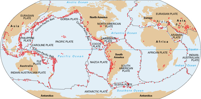
Most earthquakes occur along faults at the boundaries between Earth’s tectonic plates. Such earthquakes are called interplate quakes. Some earthquakes, called intraplate quakes, happen in the interiors of plates, away from plate boundaries.
Interplate quakes
are the most common earthquakes and generally have the largest magnitudes. The bigger a fault, the more powerful the earthquake that can strike there. There are three types of plate boundaries where earthquakes occur: (1) divergent boundaries, (2) convergent boundaries, and (3) transform boundaries.
Divergent boundaries,
also called extensional boundaries, occur where the plates are spreading apart. Most faults that occur at these boundaries are called extensional faults. Examples of these faults are common at the underwater mountains called mid-ocean ridges. Earthquakes at these faults are generally weaker than other earthquakes. Most extensional faults are normal faults.
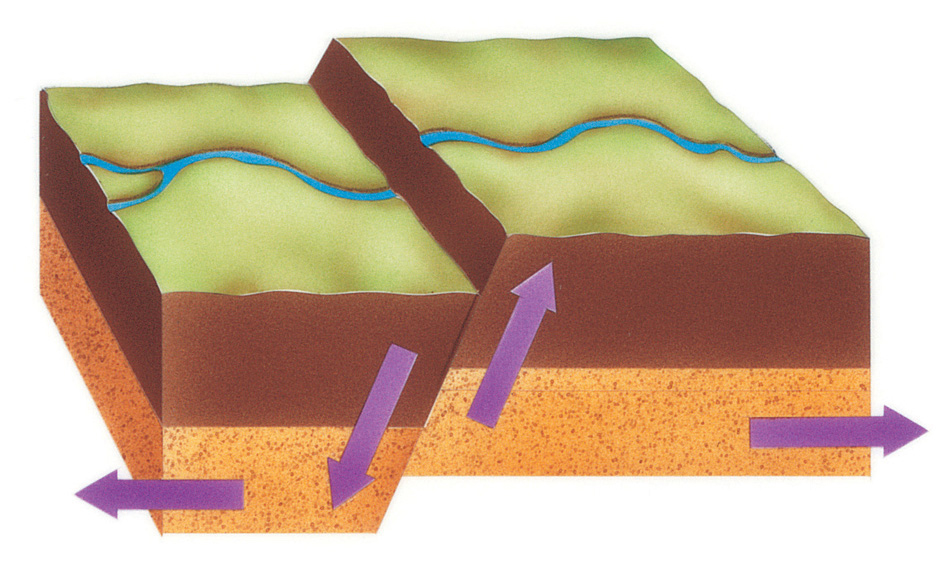
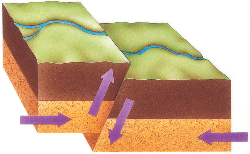
Convergent boundaries,
also called compressional boundaries, are areas where plates move towards each other. Most faults that occur at these boundaries are reverse faults, in which one plate slides up and over another plate. Convergent boundaries feature a less steep reverse fault called a thrust fault. Two examples of thrust faults are subduction zones and the zones where plates carrying continents collide. Because subduction zones are long and sloping, they can produce some of the biggest earthquakes. In addition, earthquakes due to subduction can affect broad regions. The largest earthquakes of the past century were subduction zone quakes, including that which caused the Asian tsunami of 2004 and that which struck Chile in 2010.
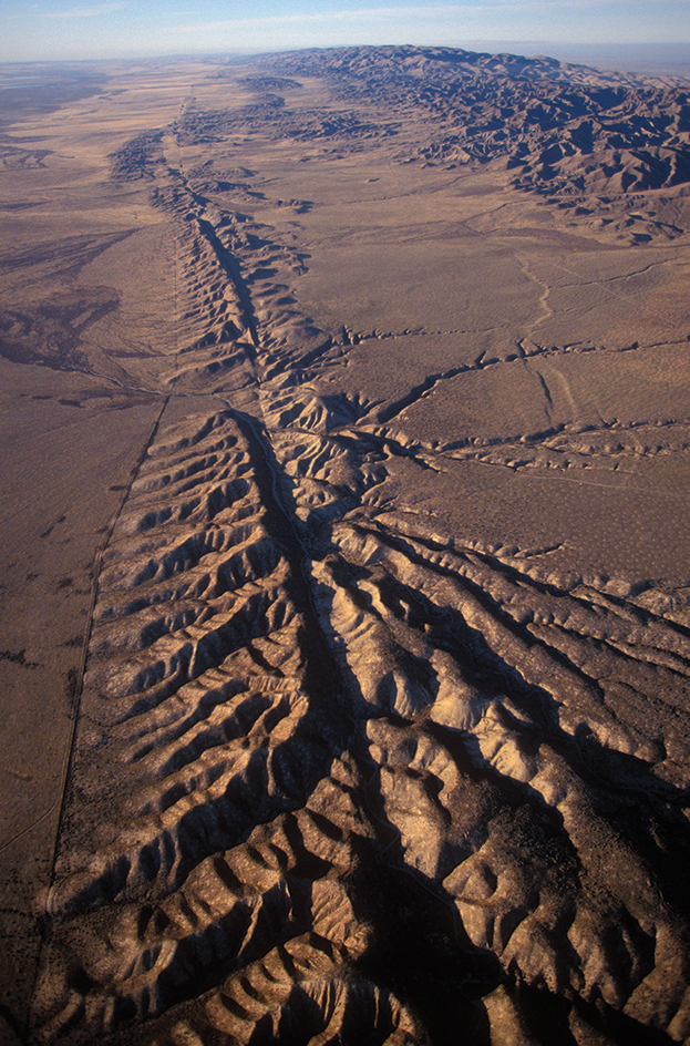
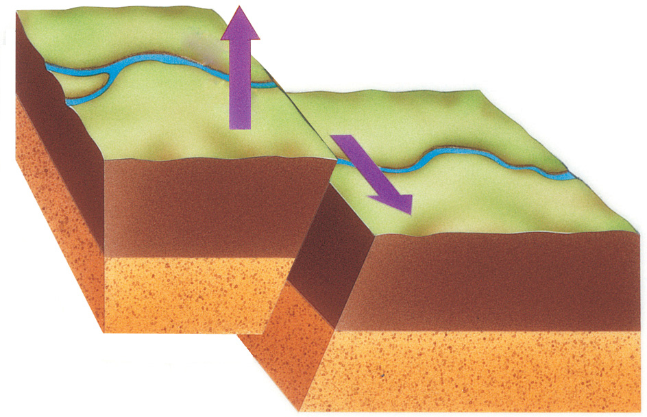
Transform boundaries,
or transcurrent boundaries, occur where two plates are sliding horizontally past each other. Most faults that occur at these boundaries are called strike-slip faults, where two blocks slide by each other without compression or stretching. The main strike-slip fault at a plate boundary is a transform fault. The San Andreas Fault in California is a strike-slip fault.
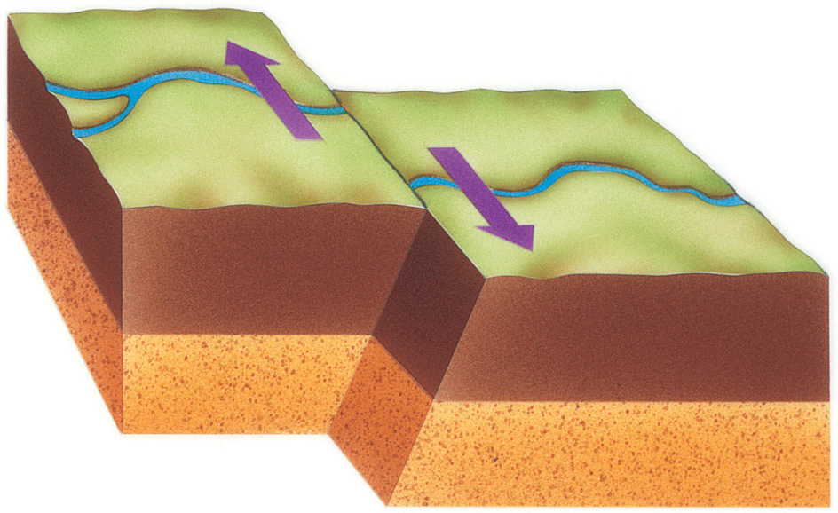
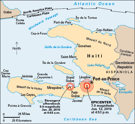
Earthquakes along transform faults usually affect smaller regions than convergent boundaries, but can still be destructive, particularly if the fault runs through a populated area. The Haiti earthquake of 2010 involved a transform fault near Haiti’s capital, Port-au-Prince.
Undersea transform faults are less dangerous. They seldom cause tsunamis. In addition, because nothing is built directly on top of undersea faults, they generally cause little damage.
Intraplate quakes
are caused by stress that builds up within plates over long periods. The quakes often occur along zones of weakness inside the plates, such as old fault lines. Quakes can also be caused by volcanic activity. Although intraplate earthquakes happen less frequently than interplate quakes, they can affect a wider region. The area is often larger because such quakes occur in the older, stronger rock in the middle of plates. The strength of the rock enables the seismic waves to travel long distances. Among the largest intraplate earthquakes were three quakes centered in New Madrid, Missouri, in 1811 and 1812. These earthquakes were so powerful that they changed the course of the Mississippi River.
Measuring earthquakes
Seismometers measure ground displacement over time at places called seismic stations. A seismometer includes a weight suspended in a frame. When the frame moves due to an earthquake, the weight does not move with it. The seismometer electronically measures the difference in motion between the weight and the frame to determine the movement of the ground. A record of ground motion plotted over time is called a seismogram. In the past, seismograms were plotted by a recording device called a seismograph attached to the seismometer. Today, computers plot seismograms. Many seismic stations include a broadband seismometer, which can detect shaking over a wide range of frequencies. If several seismic stations record an earthquake, scientists can determine the quake’s hypocenter, magnitude, and starting time. These calculations are based on the arrival times of P and S waves at each of the stations.
The Richter scale
is perhaps the best-known measurement of an earthquake’s intensity. It is also called the local magnitude (ML) scale.
The American seismologist Charles F. Richter originally defined earthquake magnitude in the 1930’s. He defined it according to the maximum ground displacement, measured in microns (millionths of a meter), recorded at 100 kilometers (62 miles) distance from the quake. On the Richter scale, a one-point increase in magnitude equals a tenfold difference in displacement. For example, magnitude 3 quakes have 1,000 microns of displacement. Magnitude 4 quakes have 10,000 microns of displacement. An increase of one point indicates that the energy is about 32 times greater.
The moment magnitude scale
is the preferred method to measure large earthquakes. Scientists determine a moment magnitude by studying the earthquake’s entire waveform—that is, all the wave types, frequencies, and durations—at numerous seismic stations. They thus can determine how much energy was released by the quake and how the energy was distributed on the fault plane. The largest earthquake ever recorded on the moment magnitude scale measured 9.5. It took place along the Pacific coast of Chile in 1960.
The Modified Mercalli Intensity (MMI) scale
measures the intensity of the shaking caused by an earthquake. Giuseppe Mercalli, an Italian volcanologist (scientist who studies volcanoes), devised the scale in 1902. Two American seismologists, Harry O. Wood and Frank Neumann, refined it in 1931. The scale describes the damage and effects of the shaking using Roman numerals ranging from I to XII. The same earthquake will have different MMI values from place to place, with the largest values near the epicenter. MMI values of VI or higher indicate that the shaking was strong enough for every person to notice it without using a seismometer.
Predicting earthquakes
A successful earthquake prediction would specify the time, location, and magnitude of the earthquake. Scientists cannot yet predict earthquakes at this level of detail. However, the history of quakes in an area can be used to calculate the probability that a large earthquake will strike within a given time. History can also suggest if one quake will be followed by a larger or smaller one within a certain period. Scientists make two types of forecasts, short-term and long-term.
Short-term forecasts
tell the likelihood of future earthquakes, just as weather forecasts give the likelihood of rain. The state of California has probability forecasts extending 24 hours into the future that are updated every hour. The forecasts are based on the pattern of recent earthquakes. The forecasts give the chance of shaking of VI or more on the MMI scale for various areas.
Long-term forecasts
use the history of large earthquakes along major faults. For example, in 1997, scientists calculated that there was a 12 percent probability of a major quake in the next 30 years near the Turkish city of Ïzmit. A major earthquake struck there two years later, in 1999. The statewide forecast for California in 2008 indicated a 46 percent chance of a magnitude 7.5 or greater earthquake in the next 30 years.
New technology can allow a few seconds up to a minute of warning at distant locations after a quake has started. Alarms can send warnings over the internet faster than earthquake waves can travel. Many countries, including Japan, Mexico, Taiwan, and Turkey, either have or are developing such alarms. Scientists and engineers are working to have earthquake warnings trigger automated responses. The responses might include slowing trains and stopping traffic at traffic lights to avoid accidents. They might also close valves on pipelines to minimize fire hazards.
Using earthquakes to study Earth’s interior
As body waves from an earthquake travel through different layers of Earth, including the mantle and core, their paths bend and their speeds change. These changes affect the time it takes for the waves to arrive at distant seismic stations. Using the global pattern of the arrival times of the seismic waves from big earthquakes, scientists have learned much about Earth’s interior. Early seismologists discovered that the most important changes to seismic waves occur at the boundaries between the crust and mantle, the mantle and outer core, and the outer core and inner core. This discovery led to the earliest descriptions of the layers of Earth’s interior.
Modern seismic networks and computer systems can detect smaller changes in seismic wave speeds within Earth’s interior layers. Over time, earthquakes occur in many different places on Earth and send seismic waves in different directions. Scientists can analyze the seismic waves passing in different directions through the same region to map the wave speed variations in three dimensions. This technique of mapping is called seismic tomography. Faster wave speeds indicate regions of material that are colder or denser than their surroundings. Regions of slower wave speeds may be material that is hotter or less dense than its surroundings.
Quakes elsewhere in the solar system
Scientists have observed or predicted seismic activity on several bodies in the solar system. From 1969 to 1972, Apollo astronauts set up seismometers on the moon. The instruments recorded tiny moonquakes up to magnitude 5.5. These quakes may result from Earth’s gravitational pull on the moon and from meteorite impacts. The sun’s heat might also cause moonquakes, as the lunar surface expands and contracts due to heating and cooling. Shaking from a moonquake lasts longer than it would on Earth. Scientists think the longer duration results from the moon rocks being drier and more broken up than Earth’s.
Mars, like Earth, is a rocky planet that has quakes. The Viking 2 space probe, launched in 1975, landed a partially functional seismometer on Mars. The device recorded wind noise and, possibly, a magnitude 3 quake. The InSight probe, launched in 2018, was designed to study the interior structure of Mars. InSight’s sensitive seismometer detected the first confirmed quakes on Mars. During its 4-year mission, InSight measured over 1,300 seismic events, including a magnitude 5 marsquake.
Mercury and Venus have some tectonic features similar to features on Earth or the moon, such as thrust faults. Strike-slip faults have been discovered on such moons as Ganymede, a moon of Jupiter, and Titan, a moon of Saturn. As a result, planetary scientists think these planets and moons could also have quakes.
