Geography is the study of where things are and why. It concerns the location and distribution of living things and of Earth’s surface features in relation to one another. Geographers study where people, animals, and plants live and their relationship with rivers, deserts, and other features. Geographers also examine where Earth features are, how they came to be there, and why their location is important. The word geography comes from the Greek word geographia, which means Earth description. Geographers describe Earth using a variety of methods, including text, charts and graphs, maps, and geographic information systems. A geographic information system is a computerized system for storing, organizing, and analyzing geographical information. It is abbreviated GIS.
Geographers search for patterns in the distribution of features over Earth’s surface. They may try to discover why some rivers flood more often than others. Geographers also look for and study patterns in human economic, political, and social activities. For instance, geographers analyze where cities are around the world. They also study the relationship between these locations and the climate, terrain, and other factors.
Geographers want to know about the forces that create and change the landscape. For this reason, they study climate and the alterations caused by such natural forces as wind and water. Geographers are also interested in how human beings change Earth. For example, geographers may analyze how the expansion of a city affects a nearby river. In addition, they examine the ways in which Earth’s surface has changed over time. They may study how a city has grown or climate patterns from hundreds of years ago.
Geographers often share the data and information that they gather with scientists in other fields. Such fields include anthropology, biology, economics, geology, physics, and sociology. Scientists analyze the information to answer questions about Earth’s surface. Maps display geographic findings. Geographers also rely on fieldwork, surveying, interviewing, GIS’s, and statistics.
Study of geography
Geography considers four main types of questions. They deal with (1) location, (2) spatial relations, (3) regional characteristics, and (4) the forces that change Earth.
Location.
One of the main tasks of geographers is to identify and record the location of places, of Earth features, and of human populations and activities. To do this, geographers have marked off Earth’s surface with meridians and parallels. Meridians are imaginary lines that run north and south. They measure longitude (position east or west of the prime meridian). Parallels are imaginary lines that run east and west. They measure latitude (position north or south of the equator). Meridians and parallels intersect at right angles to form a grid.
Geographers can use different techniques to identify the position of anything on Earth’s surface. Geographers may determine the location of features by surveying. They may also use a satellite network, such as the Global Positioning System (GPS). GPS devices use radio signals from satellites to find latitude and longitude. This information can be transferred to a map, often through the use of a geographic information system.
Spatial relations
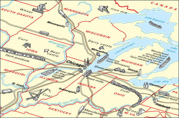
are relations in position among places, Earth features, and groups of people or other living things. Spatial relations are important in the development of a place and the activities of its people. For example, many industrial cities have developed along transportation routes, rather than near rich mineral deposits. Geographers often analyze spatial relations using statistics.
Regional characteristics.
Few people are satisfied to know only the location of a place. Most also want to know its characteristics. They are interested in the people who live there, how the people build their cities, and how they use their land. People also want to know about a region’s landforms and climate and the types of animals and plants that are found there. Geographers record these data. They use this information to compare and contrast regional variations.
Forces that change Earth.
Earth’s surface changes constantly. For example, people move from one place to another. New homes may be built on land that was once farmland. Some changes result from natural forces. For example, erosion by water creates canyons. The action of ocean currents can alter a coastline. At times, human activities can combine with natural processes to change Earth’s surface. For example, the Sahara, a desert in Africa, has expanded as farmers have grazed their livestock too heavily on nearby grasslands. Geographers study such processes to see how landscapes developed in the past and how they may change in the future.
Subfields of geography
The study of geography can be divided in several ways. Some geographic studies focus on a particular region or topic. Others deal with the physical environment, human activity, or environmental conservation.
Regional geography
deals with a particular place or region. For example, geographers studying the Persian Gulf region would examine its climate, landforms, and natural resources. They would also study its populations, religions, languages, and political divisions.
Topical geography
concentrates on one Earth feature or human activity as it occurs around the world. A topical study might deal with worldwide patterns of soil quality or of railroad transportation, for example.
Physical geography
concerns the locations of such Earth features as land, water, and climate; their relationship to one another and to human activities; and the forces that create and change them. Physical geography includes the specializations geomorphology, climatology, biogeography, and oceanography.
Geomorphology
is the study of landforms and soils, including their distribution and origin and the forces that change them. For example, geomorphologists study where and why avalanches and earthquakes occur and how glaciers move. They also examine the relationship between landforms and human activities.
Climatology
concentrates on patterns of climate. Climatologists study such factors as temperature, precipitation, and humidity. They also study how climate changes and how it is affected by human activity.
Biogeography
includes plant geography and zoogeography. Plant geographers study patterns of vegetation growth and how plant growth is affected by changes in climate, soil, and human activity. Plant geography is also called phytogeography. Zoogeographers study why animals live in particular regions. They also investigate the migration of animals and factors that affect animals’ movements.
Oceanography
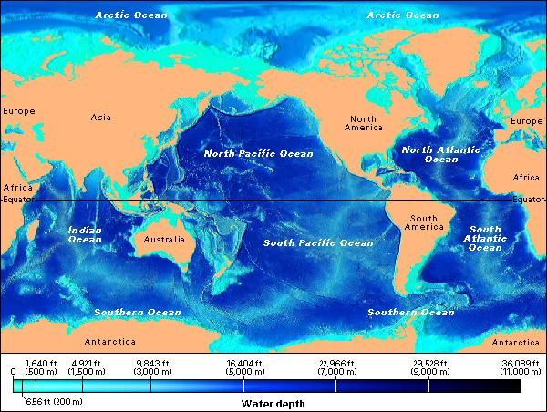
includes the study of ocean currents, waves, and tides. Oceanographers also explore the geography of the ocean floor.
Human geography
focuses on patterns of human activity and people’s relationships with the environment. Fields of human geography include cultural geography, population geography, social geography, urban geography, economic geography, and political geography.
Cultural geography
examines the location and historical spread of beliefs, customs, and other cultural traits. For example, cultural geographers might study the spread of a set of religious beliefs. Or they might explore how a people’s cultural practices have changed the part of Earth where they live.
Population geography
is concerned with patterns of population and changes in those patterns. Population geographers study birth and death rates, population movements, family size, and other statistical data.
Social geography
examines the relationships among groups of people. Social geographers try to analyze how these social relationships affect the places where people live, work, and play.
Urban geography
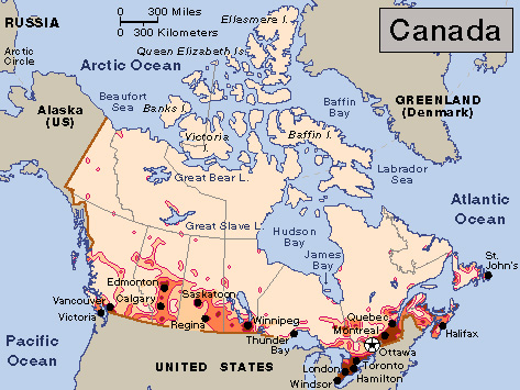
deals with cities and other urban areas. Urban geographers examine how location may be important in the development of cities and other communities. They may investigate where different groups live within a city or why slums develop where they do.
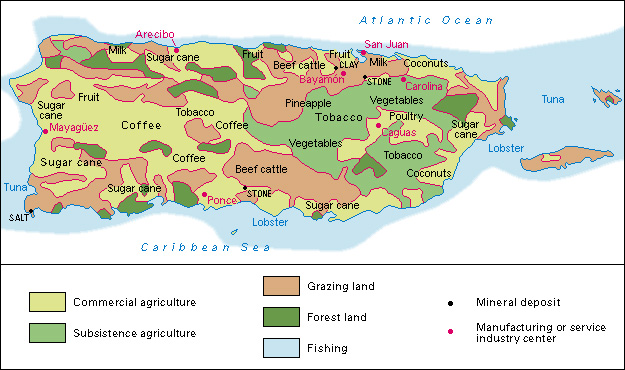
Economic geography
involves the location and distribution of such economic activities as mining, manufacturing, and agriculture. Economic geographers study the environmental and human factors that affect business and industry. Such factors include transportation, labor supply, climate, and resources.
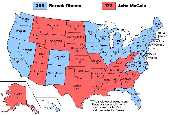
Political geography
deals with the ways people in different places make decisions or gain and use power within a political system. Political geographers study such topics as changes in political boundaries, problems of political instability, and patterns of voting.
Environmental conservation
combines information from both physical geography and human geography at the local, regional, national, and international scales. Environmental issues are complex. Geographers study them by combining the research methods of both physical science and social science.
Current environmental concerns that fall within the scope of geographic research include global warming, water shortages, agricultural sustainability, and energy use. Sustainability involves environmentally sound practices that protect natural resources. At the local level, for example, geographers study the production and distribution of local foods. Their objects of study include the ecological factors that influence natural farming methods, changes in agricultural land use, and policies that influence farmers. At the global level, geographers use GIS’s to model climate change. They gather huge sets of data on precipitation, temperature, wind speed, and other factors to create maps for studying future climate patterns. These models may also project different scenarios based on variations in human activity. Such variations might include changes in carbon dioxide (CO2) emissions or in national environmental policy.
How geographers work
Geographers use specialized methods to study Earth features and human activities. These methods include (1) field study, (2) mapping and geospatial techniques, (3) interviewing, (4) quantitative analysis, and (5) the use of scientific instruments.
Field study.
Since ancient times, people have relied on direct observation to learn about Earth’s surface and patterns in human activity. Today, direct observation remains an important research method. Geographers often travel to a region to answer specific questions or to learn about unfamiliar geographic relationships. For example, geographers may study the appearance of an area to help plan new buildings or parks. They might also observe a farming area suffering from erosion.
Mapping
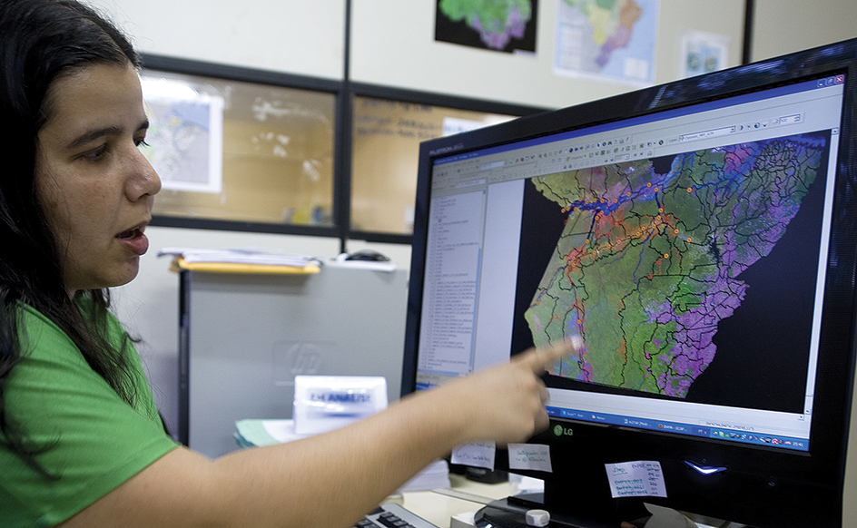
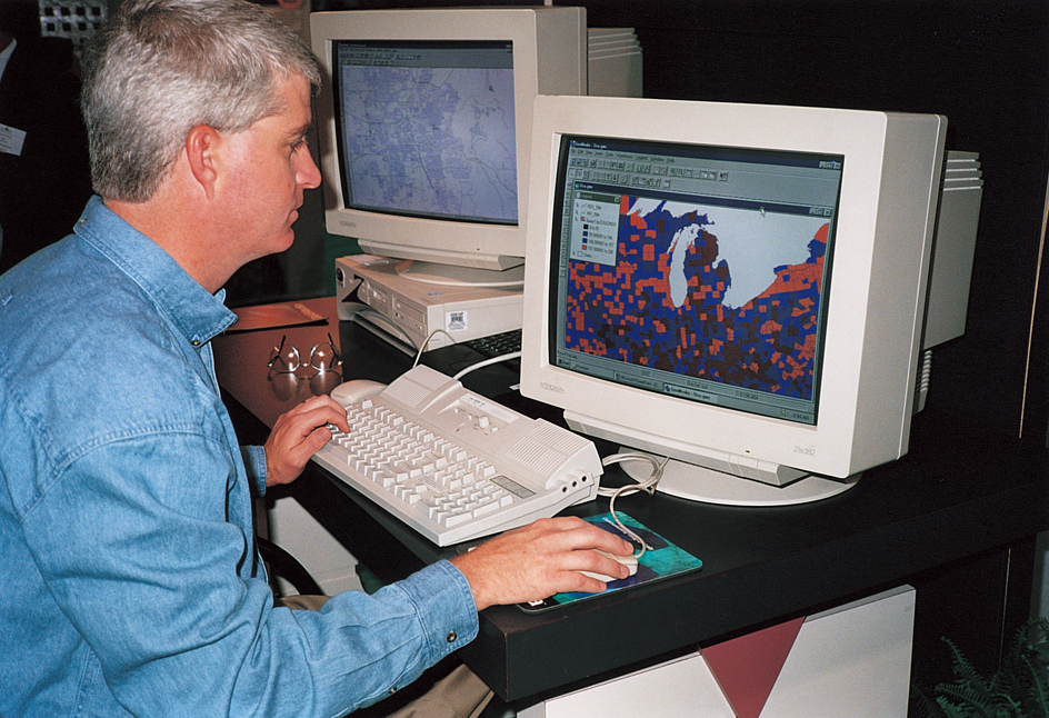
is one of the geographer’s most basic activities. Most modern geographers use computer-based GIS’s to build layers of data and combine them into maps. Remote sensing is the use of satellite images or aerial photos to create layers of information about a given location. Geographers can use GIS and remote sensing to map national parks or “see” the deforestation of a tropical rain forest. Geographers who specialize in designing maps are called cartographers. Those who particularly specialize in geospatial techniques—GIS and remote sensing—are often called geospatial analysts. See Map .
Interviewing.
Some geographical questions cannot be answered by observation alone. Geographers may want to study the attitudes of people toward certain places. Or, they may wonder how people’s beliefs and activities affect their surroundings. Geographers get this information by interviewing people. They usually do not interview the entire group being studied. Instead, they interview a portion of the group scientifically chosen to reflect the entire population. The process of selecting subjects from an area is known as spatial sampling.
Quantitative analysis
is the use of mathematical and statistical data and techniques. Geographers often use quantitative methods to test their research. Quantitative methods also help geographers find hidden patterns in geographic elements. Quantitative information is often displayed through maps, usually with the help of GIS.
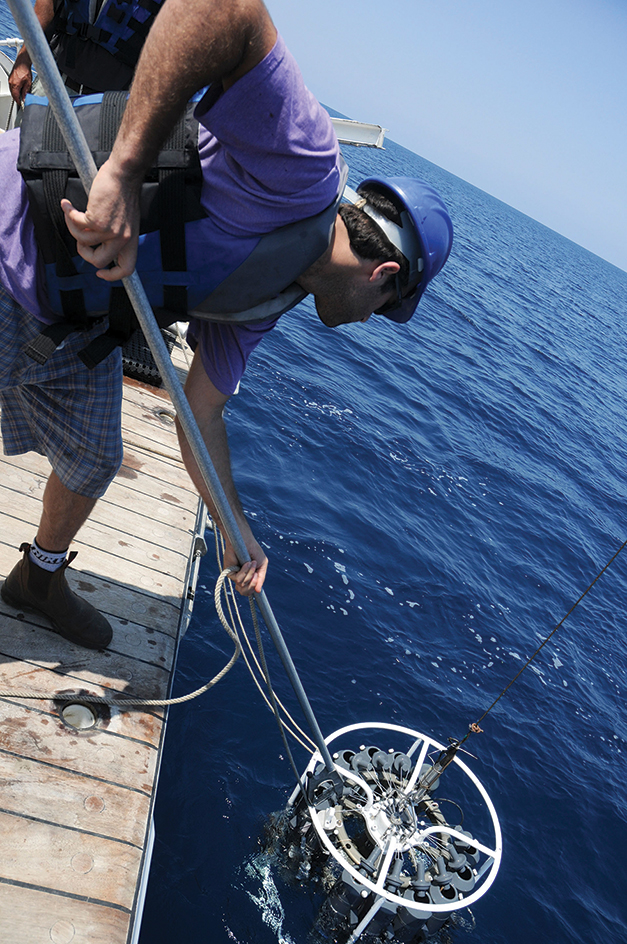
Scientific instruments
are necessary for much geographic research. Geographers use remote-sensing devices to identify and study physical features that are large or hard to reach. These devices include aerial and satellite cameras, heat-sensitive infrared cameras, and radar. Aerial and satellite cameras record information about weather systems, patterns of vegetation growth, and the spread of pollution. Infrared photography reveals information invisible to the human eye. For example, infrared photographs may show diseased and healthy trees in different colors, even though the trees appear the same to the human eye. Airborne radar can produce photographs similar to aerial photographs, regardless of the weather or time of day (see Radar (Pulse radar) ).
Some scientific instruments gather environmental data. For example, weather gauges measure and record temperature, humidity, wind speed and direction, and air pressure.
Geographers use GPS equipment to find the precise location of surface features and to measure their distance from other features. Some Earth features are so large or change so slowly that geographers can study them best by creating a model. Geographers use models to study such geographic processes as the flow of rivers, variations in climate, the movements of glaciers, and the effects of tornadoes.
History
Many ancient peoples, including the Egyptians and Phoenicians, traveled through much of Europe and Africa. These explorers journeyed primarily for reasons of trade and conquest. As they traveled to unfamiliar areas, however, they also added to what was known about those places. In addition, they became skilled in mapping. Early maps were simply crude drawings showing distance and direction. As travel became more common, maps became more accurate and detailed.
Early study.
The ancient Greeks were the first people of Europe to study geography in a systematic way. They tried to explain how the geographic traits of a region affected its inhabitants. Beginning in the 600’s B.C., the Greeks mapped the seacoasts of their own region and the rest of the Mediterranean Sea. In the 200’s B.C., the Greek mathematician Eratosthenes calculated Earth’s polar circumference. The polar circumference is the distance around the Earth, measured through the poles. Eratosthenes’s calculation was reasonably close to today’s measurement. About 200 years later, the Greek scholar Strabo wrote a 17-volume geographic study of what was then the known world.
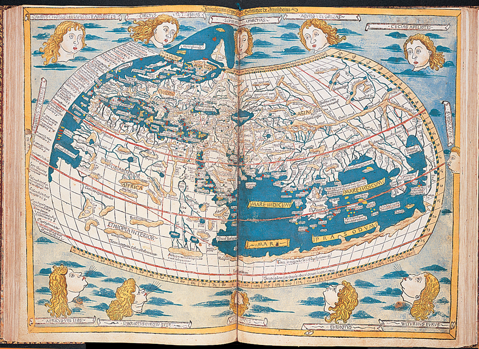
The Romans also contributed to the study of geography during their widespread military campaigns. In the A.D. 100’s, the geographer Ptolemy became famous for his mapping skills and his studies of astronomy. Many of his theories were later proved to be wrong. But people believed them for centuries. In fact, his error in estimating the distance between Spain and China encouraged Christopher Columbus to make his famous voyage in 1492. Columbus, an Italian sea captain, sailed from Spain in search of a westward sea route to Asia. Instead, he landed in America.
Much of the geographic knowledge recorded by the Greeks and Romans was lost from Europe in the early Middle Ages. This period lasted from about the 400’s to the 900’s. However, the Muslims of the Middle East and North Africa continued to study geography and to make discoveries of their own.
Era of exploration.
During the late Middle Ages, which lasted from about the 1000’s through the 1400’s, Europeans began to travel outside their own region. Soldiers traveled to the Middle East on the Crusades, a series of expeditions to spread the Christian faith. During the 1200’s, the Italian trader Marco Polo journeyed to China. He recorded his travels in a book that includes geographic information about the lands he visited and their inhabitants. Before about 1400, most Europeans knew little about world geography. Many maps of this period show huge, unknown areas decorated with drawings of dragons, sea serpents, and other imaginary creatures.
During the 1400’s and 1500’s, the Spaniards and Portuguese began to make long voyages of exploration. In 1492, Columbus landed in America. Vasco da Gama, a Portuguese navigator, sailed around the southern tip of Africa in 1497. He reached India in 1498. In 1519, another Portuguese navigator, Ferdinand Magellan, set out on an expedition to sail around the world. Magellan was killed on the journey. But one of his ships completed the voyage. Also at this time, the Dutch, English, and French began to explore unfamiliar lands. These voyages resulted in an explosion of new information about geography.
From the 1500’s to the early 1800’s, European nations wanted to colonize other places and get their natural resources. So their explorers mapped many regions of North and South America and the interior of Africa. During the early 1900’s, expeditions revealed more information about the Middle East and the North and South poles. Exploration of the poles continues today. People also have explored the ocean floors. For additional information about the exploration of Earth, see Exploration .
The growth of geography.
Geography and geology were long considered the same study. Around the 1820’s, they each became established as separate fields. Geography achieved this status largely because of the work of the German geographers Alexander von Humboldt and Karl Ritter. The first university geography departments were established during the mid-1800’s.
Until about 1920, most geographers were physical geographers. Gradually, geographers began to emphasize the relationships between Earth’s features and human activity. The American geographer Ellen Churchill Semple defined geography as the study of the environment’s influence on human history. Carl O. Sauer, also of the United States, studied how cultural differences influence environmental surroundings. During the 1930’s, the German geographer Walter Christaller examined the growth and distribution of human settlements. In the 1950’s, Torsten Hägerstrand of Sweden developed theories for predicting the diffusion of human customs. From the 1960’s on, the work of the American geographer Gilbert White inspired many geographers to seek out solutions to practical problems.
The geospatial era.
Since the 1980’s, many geographers have chosen to study geospatial techniques, responding to demand for computer analysis and maps of global environmental change. Such specialists provide important information for planning the growth of urban areas and the management of natural resources. In addition, geographers have made greater attempts to predict how physical processes and human activity will affect Earth in the future. To do this, many rely on fieldwork, statistical analysis, and GIS techniques.
Careers in geography
Geographers work in a variety of jobs. Many geographers work as GIS specialists, employing their data analysis skills. Some work for state or local governments as planners, land-use specialists, community development experts, and cartographers. Many geographers work for national governments. For example, governments employ geographers in the departments that manage census taking, international relations, and natural resources. Private industry employs economic and population geographers as well as experts in weather forecasting, cartography, land use, and resource management. Still other geographers teach geography in high schools and colleges.
Most geography jobs in government and private industry require at least a bachelor’s degree. Higher positions in government and industry, and nearly all academic posts, require a master’s or doctor’s degree.
Geographers must be able to design and read maps. In addition, they should know statistics. They should know how to interpret data obtained from remote sensing devices and use these data in GIS mapping. Geographers must also write well so they can communicate their ideas to others. Many jobs require knowledge on a range of subjects. For example, a geographer who wants to work in resource management should also know chemistry, geology, economics, and politics.
The major association of geographers throughout the world is the International Geographical Union (IGU). It encourages international cooperation to advance the study of geography. IGU headquarters are in Brussels, Belgium.
