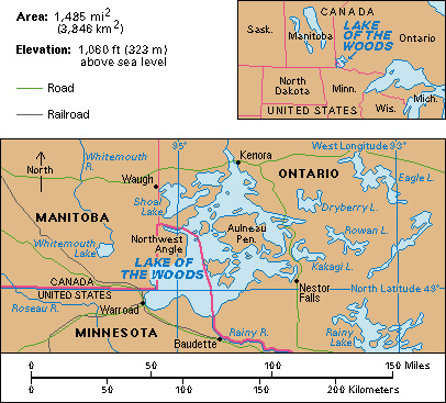
Lake of the Woods lies on the boundary between Canada and the United States. Some of the first trading posts in the West were located on the shores of this lake. Today, the lake is best known as a summer resort. It was named for the forests that cover its hilly shores and islands. The lake covers about 1,485 square miles (3,846 square kilometers), most of which lie in Ontario. Two small bays are in Manitoba. The rest of the lake borders Minnesota. The northernmost part of the continental United States, excluding Alaska, is on the lake’s western shore. The lake is 100 miles (160 kilometers) long and from 10 to 50 miles (16 to 80 kilometers) wide.

Tourism is the chief industry of the region. Fishing, particularly sport fishing, also is important. Highways and railways run along the lake’s northern and southern shores.
The Lake of the Woods was an important factor in several boundary disputes between the United States and the United Kingdom. According to the treaty that ended the Revolutionary War in America (1775-1783), the boundary was to run from the northwest angle of the lake “on a due course west to the river Mississippi.” The source of the Mississippi was later found to be 100 miles (160 kilometers) farther south. The Convention of London fixed the present boundary in 1818.
