Mount Pinatubo is a volcanic mountain on the island of Luzon in the Philippines. It lies about 55 miles (90 kilometers) northwest of Manila. Mount Pinatubo rises 4,875 feet (1,486 meters) and is part of the Ring of Fire, a belt of volcanoes encircling the Pacific Ocean.
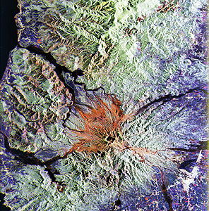
On April 2, 1991, villagers noticed the first signs of volcanic activity on Mount Pinatubo, which had not erupted for more than 600 years. Steam began exploding from the side of the mountain. On June 15, a powerful eruption tore away the top of the volcano and left a caldera (crater) about 11/4 miles (2 kilometers) wide. Lava flowed down the mountain, and rock fragments and ash shot 22 miles (35 kilometers) into the air. Monsoon rains that fell after the eruption caused avalanches of volcanic ash and debris. The avalanches damaged buildings, choked rivers, and killed hundreds of people. The eruption also released about 20 million short tons (18 million metric tons) of sulfur dioxide into the atmosphere.
