Ocean is the great body of water that covers nearly 71 percent of Earth’s surface. People also call it the sea. The ocean contains 97 percent of all the water on Earth.
The ocean serves as a source of food, energy, minerals, and recreation. Ships sail the ocean to carry cargo between continents. The sea also plays a major role in Earth’s climate system by regulating the air temperature and by supplying the moisture for rainfall. If there were no ocean, life could not exist on our planet.
The bottom of the ocean has features as varied as those on land. Huge plains spread across the ocean floor, and long mountain chains rise toward the surface. Volcanoes erupt from the ocean bottom, and trenches and valleys plunge to great depths.
Scientists called oceanographers work to discover the ocean’s secrets. They study how the ocean moves and how it affects the atmosphere. They investigate the chemical composition of seawater and monitor the various forces that shape the sea floor. They also study how organisms live in the sea and how people have affected the ocean.
The world ocean
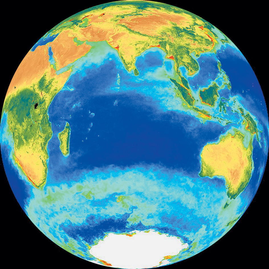
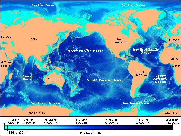
The ocean forms one great connected body of water often called the world ocean or the global ocean. The continents divide the world ocean into five major parts. They are the Pacific Ocean, the Atlantic Ocean, the Indian Ocean, the Southern Ocean, and the Arctic Ocean. Each ocean includes smaller bodies of water called seas, gulfs, or bays, which lie along the ocean margins. For example, the Caribbean Sea and the Mediterranean Sea are part of the Atlantic, and the Bering Sea and the South China Sea are part of the Pacific. The word sea also refers to the ocean in general.
The world ocean contains about 97 percent of all the water on Earth. Most of the remaining water occurs frozen in ice sheets and other ice formations. The rest is underground, in the air, or in such bodies of water as lakes and rivers.
Area.
The world ocean covers about 71 percent of Earth’s surface. Most of the ocean lies in the Southern Hemisphere—that is, south of the equator. The Southern Hemisphere consists of about 80 percent ocean, and the Northern Hemisphere about 60 percent.
The Pacific Ocean ranks as the largest ocean by far. It covers about 66 million square miles (171 million square kilometers)—about one-third of Earth’s surface. Near the equator, the Pacific stretches about 11,000 miles (17,700 kilometers) from Panama to the Malay Peninsula. North and South America border the Pacific on the east, and Asia and Australia lie to the west. To the north, the Bering Strait links the Pacific with the Arctic Ocean. See Pacific Ocean.
The Atlantic Ocean covers about 34 million square miles (88 million square kilometers). Europe and Africa lie east of the Atlantic, and North and South America lie west. See Atlantic Ocean.
The Indian Ocean has an area of about 26.6 million square miles (69 million square kilometers). Africa lies to the west. Australia and Indonesia lie to the east. Asia borders the Indian Ocean on the north. See Indian Ocean.
The Southern Ocean covers about 8.5 million square miles (22 million square kilometers). It surrounds the continent of Antarctica. See Southern Ocean.
The Arctic Ocean covers about 3.7 million square miles (9.6 million square kilometers). It is bounded by Asia, Europe, and North America. See Arctic Ocean.
Depth.
The world ocean has an average depth of 13,000 feet (4,000 meters), but parts of the ocean plunge much deeper. The deepest areas occur in trenches—long, narrow valleys on the sea floor. The deepest known spot is in the Mariana Trench in the western Pacific Ocean, near the island of Guam. It lies about 35,840 feet (10,930 meters) below sea level. If the world’s highest mountain, 29,032-foot (8,849-meter) Mount Everest, were placed in that spot, more than 1.3 miles (2.1 kilometers) of water would cover the mountaintop.
The Java Trench is the lowest point in the Indian Ocean. It lies about 23,600 feet (about 7,190 meters) deep. The deepest point of the Atlantic lies in the Puerto Rico Trench at 27,480 feet (8,380 meters) below the surface. The deepest point in the Southern Ocean is found about 24,390 feet (7,430 meters) below sea level at the southern end of the South Sandwich Trench. The Arctic’s deepest point lies in a deep plain northwest of the islands of Svalbard about 18,210 feet (5,550 meters) below sea level.
Ocean zones.
Oceanographers divide the ocean into zones based on the characteristics of different areas of water. Such characteristics can include depth, water temperature, and distance from land. The ocean can be divided into zones in different ways, depending on which characteristics are considered. One important way scientists define ocean zones is by dividing the water column into horizontal layers based on depth, temperature, and the amount of sunlight that penetrates the water. The water column is the vertical cross-section of the open ocean, from the surface to the ocean floor. Scientists do not agree on the boundaries between zones, or even on the number of zones in the water column. However, many scientists divide the water column into five zones called the epipelagic, mesopelagic, bathypelagic, abyssopelagic, and hadalpelagic zones.
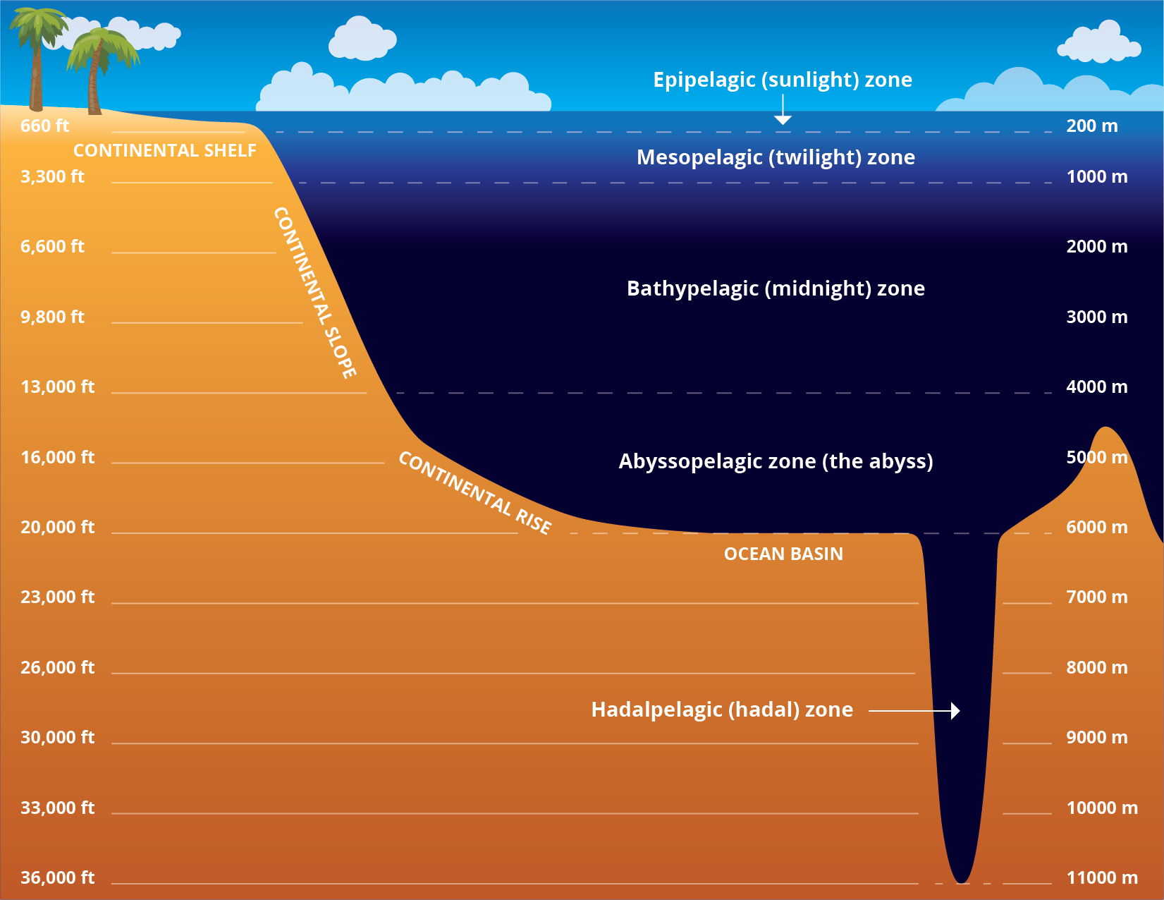
The epipelagic zone (also called the sunlight zone) extends from the surface to about 660 feet (200 meters) below the surface. This zone is the warmest, because it is heated directly by sunlight. Many organisms that get their food through photosynthesis live in the epipelagic zone. The temperature of the epipelagic zone varies by geographic location. It is very cold toward the poles—about 28 °F (–2 °C)—and warmer in tropical waters—above 86 °F (30 °C). However, in a given location, the temperature is relatively consistent throughout the depth of the epipelagic zone. Its closeness to the surface means that wind and ocean currents can mix the water to evenly distribute heat.
The mesopelagic zone (also called the middle pelagic zone or the twilight zone) extends from about 660 feet (200 meters) to 3,300 feet (1,000 meters) deep. Unlike the epipelagic zone above it (which is consistently warm) and the zones below it (which are consistently cold), the mesopelagic zone ranges in temperature. The mesopelagic zone is where the thermocline is found (described in the section Temperature below). The mesopelagic zone is also called the twilight zone, because only a faint amount of light penetrates to this depth. There is not enough light for organisms to depend on photosynthesis for food.
The bathypelagic zone (also called the bathyal zone or the midnight zone) extends from about 3,300 feet (1,000 meters) to 13,000 feet (4,000 meters). It is consistently very cold, around 39 °F (4 °C). The bathypelagic zone is also known as the midnight zone, because no sunlight can penetrate to this depth. The species that live in this zone have developed adaptations to the extreme darkness. Many organisms are bioluminescent—that is, they give off light.
The abyssopelagic zone (also called the abyssal zone or “the abyss”) extends from about 13,000 feet (4,000 meters) to 20,000 feet (6,000 meters), or the sea floor in most areas. The water temperature is close to freezing. Because no photosynthesis can take place at this depth, marine snow (debris) that floats down from upper zones is the primary source of food.
The hadalpelagic zone (also called the hadal zone) includes the water column inside trenches (depressions) in the ocean floor. These trenches can be over 33,000 feet (10,000 meters) deep. The water temperature in most trenches is barely above freezing. However, in cracks in the ocean floor called hydrothermal vents, where heated water flows or spews out, the temperature can be over 840 °F (450 °C).
Temperature.
The surface temperature of the ocean varies from about 28 °F (–2 °C) near the North and South poles to about 86 °F (30 °C) near the equator. In the polar regions, the surface seawater freezes. The western tropical Pacific has the warmest surface water. Ocean currents affect the surface temperature. Some currents carry warm tropical water toward the poles. Other currents bring cold surface waters from the poles toward the equator.
Ocean temperature also varies with depth. In general, the temperature falls as the depth increases. The warm surface waters extend to depths of about 500 to 1,000 feet (150 to 300 meters). Below the surface waters, the temperature decreases rapidly, forming a layer called the thermocline. The thermocline varies in thickness, from about 1,000 to 3,000 feet (300 to 900 meters). From the thermocline to the sea floor, the temperature decreases more slowly. Ocean temperature ranges between 34 and 39 °F (1 and 4 °C) near the bottom. In some regions, colder and deeper water rises to the surface, lowering the surface water temperature.
Composition.
The ocean likely contains every natural chemical element. But the sea is best known for its salts. On average, the weight of seawater contains about 3.5 percent salts. Eleven ions, or molecules with electrical charges, account for the ocean’s salinity (saltiness). They are, in order of concentration, chloride, sodium, sulfate, magnesium, calcium, potassium, bicarbonate, bromide, borate, strontium, and fluoride. The most abundant form of salt consists of the ions sodium and chloride.
Many ions in the ocean come chiefly from the dissolving of rocks on land. As rocks break down, rivers carry the resulting ions to the ocean. Volcanoes and undersea hot springs also contribute ions to the ocean. Evaporation and precipitation further affect ocean salinity. Evaporation removes fresh water from the ocean surface, leaving behind the salts. Precipitation, however, returns fresh water to the ocean. Evaporation in subtropical areas is greater than precipitation, so these areas have especially salty surface waters. Closer to the equator, precipitation is greater than evaporation, making surface waters less salty there. Rivers also bring fresh water to the ocean, which lowers the salinity of seawater near river mouths.
The importance of the ocean
As a wealth of resources.
The ocean provides many major resources. They include (1) food, (2) sources of energy, (3) sediments, and (4) medicines.
Food
from the ocean consists mainly of fish and shellfish. Most of the catch comes from coastal waters. The world’s fishing fleets harvest many kinds of fish and shellfish. The chief kinds include anchovies, haddock, herring, lobsters, mackerel, oysters, sardines, shrimp, and tuna. The fishing industry also is harvesting less familiar types of seafood and developing new products and markets for the catch. For example, surimi, a fish product developed in Japan, can be made into imitation crab, lobster, scallop, and shrimp. Processors use a wide variety of fish not traditionally eaten, including certain species of flounder, to make protein powders for enriching foods.
Seaweeds also serve as a source of food, in addition to having industrial uses. Kelp, a large seaweed, is one of the most important. Kelp contains such nutrients as iodine and potassium. However, its chief value is as a source of algin, a thickening substance used in making ice cream, salad dressing, cosmetics, and many other products.
People farm the ocean much as they farm the land. In a type of farming called aquaculture or mariculture, farmers raise fish, shellfish, and seaweeds near ocean shores as well as in ponds. They use special methods to make the animals and seaweeds grow faster and larger than they would in the wild. Fish hatcheries, a related management technique, produce healthy young salmon and other young fish for release into the ocean. See Aquaculture.
Sources of energy
from the ocean have several forms. Petroleum and natural gas rank as the ocean’s most valuable energy resources. Offshore wells tap deposits of oil and gas beneath the sea floor. Today, about 30 percent of worldwide oil and gas comes from offshore production. Scientists think that there are huge reserves of oil and gas still remaining beneath the ocean floor. As gas and oil reserves on land are used up or become too difficult and expensive to obtain, undersea deposits will become increasingly important.
The ocean tides also provide energy. Tidal power facilities use the energy in the rise and fall of the tides to produce electric power. Unlike petroleum and gas, this source of energy is renewable. The first tidal power plant opened in 1966 on the Rance River near St.-Malo, France. Ocean waves also provide potential sources of renewable energy. See Energy supply (Water power).
Sediments
are materials deposited at the bottom of the ocean. Ocean sediments collect as sand, mud, minerals, and other materials. Important sediments recovered from the ocean include sand and gravel mined from the sea floor and used to make construction materials. People also use some sand to restore damaged beaches. Seawater itself contains such important minerals as bromide and magnesium. These minerals can be removed by letting seawater evaporate in large shallow basins under sunlight. The evaporation leaves the mineral deposits behind in the form of salts The salts themselves and such elements as magnesium and bromide can be extracted from the deposits. Other methods to remove minerals from seawater include chemical and electrochemical processes.
The mineral wealth of the ocean extends to the deep-sea floor. The deep-sea floor contains vents from which hot water flows. Deposits at these hydrothermal vents contain copper, iron, and zinc. But mining the ores would prove expensive and difficult, and the techniques must still be developed. Manganese deposits lie on the ocean bottom in lumps called nodules. The nodules also contain valuable amounts of cobalt, copper, and nickel. Possible techniques to mine these nodules include using buckets that run on conveyor belts between a ship and the sea floor, or operating a device that works like a giant vacuum cleaner.
Medicines
may be produced from many forms of marine life. For example, plantlike organisms called red algae could provide anticoagulants, drugs that keep blood from clotting. A family of marine snails produces substances that may treat pain. Sea life has also aided medical research. The blood of horseshoe crabs contains a substance used to test for infections and bacteria contamination. Researchers study nerve cells from lobsters, squids, and marine worms to learn more about how the human nervous system functions.
Other products
from the ocean include coral, pearls, and shells used in jewelry. Many people believe that natural sponges from the ocean bottom are of higher quality than synthetic sponges. In many dry areas near seacoasts, people desalinate (remove the salt from) seawater to produce fresh water for drinking and industrial uses (see Water (Fresh water from the sea)).
As an influence on climate.
The ocean helps stabilize Earth’s climate. The ocean’s great size and the slowness of water to change temperature have a steadying influence on the temperature of the atmosphere. In summer, the ocean stores heat from the sun. In winter, when the sunlight is weaker, the ocean releases the stored heat into the air. Currents carry the heat of tropical waters toward the poles, thereby cooling the tropics and warming the polar regions.
The ocean is the source of most precipitation that falls to the earth. The sun’s heat evaporates water from the ocean surface. The water rises as invisible vapor and forms clouds as it cools. It then falls back to the earth as rain, sleet, hail, or snow.
As a vast highway.
The ocean has been a highway for trade since people built the first ships thousands of years ago. Shipping ranks as an important use of the ocean in international trade. See Ship; Transportation.
Life in the ocean
An incredible variety of living things resides in the ocean. Marine life ranges in size from microscopic one-celled organisms to the blue whale, which may measure up to 100 feet (30 meters) long. In a process called photosynthesis, ocean plants and plantlike animals use sunlight, carbon dioxide, water, and nutrients to produce their own food and materials for growth. Sea animals eat these organisms and one another. Marine plants and plantlike organisms can live only in the sunlit surface waters of the ocean, which is called the photic zone. The photic zone extends only about 330 feet (100 meters) below the surface. Beyond that point, the light is insufficient to support organisms that rely on photosynthesis. Animals, however, live throughout the ocean, from the surface waters to the greatest depths.
Loading the player...Animals of the oceans
Three basic categories of marine organisms inhabit the oceans. They are (1) the plankton, (2) the nekton, and (3) the benthos.
The plankton
includes plantlike organisms and animals that drift with ocean currents. They have little ability to move through water on their own. Most of them are so small that they cannot be seen without a microscope. Plantlike organisms of the plankton are called phytoplankton, and they include such simple creatures as diatoms and other algae. Animals of the plankton are among the organisms known as zooplankton. 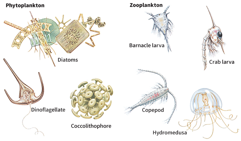
Phytoplankton
consist of several kinds of plantlike organisms. Most have only one cell and float in the photic zone, where they obtain sunlight and nutrients for photosynthesis. Although the organisms generally drift about, some kinds have long, whiplike parts called flagella that enable them to swim. Phytoplankton serve as food for zooplankton and some larger marine animals.
The most numerous phytoplankton are diatoms and dinoflagellates. A diatom consists of one cell enclosed in a hard, glasslike shell made of silica. Diatoms live mainly in colder regions of the ocean. Some even live within sea ice. Most dinoflagellates also are one-celled organisms. They generally live in more tropical regions. A dinoflagellate has two flagella it can use to move in a swirling motion. Sudden increases in certain dinoflagellate populations are called red tides, from the reddish discoloration that millions of these cells create in the water. Some dinoflagellates produce powerful poisons. When such species become plentiful, they may create a red tide that kills many sea animals (see Red tide). Other kinds of phytoplankton include coccolithophores, one-celled organisms with a hard shell made of calcite; and silicoflagellates, which have a skeleton of hollow silica rods.
Zooplankton
consist of many kinds of creatures, such as single-celled organisms and small animals that are unable to swim. They live at all depths in the ocean. Some planktonic animals float about freely throughout their lives. The rest spend only the early part of their lives as plankton. As adults, some become strong swimmers and join the nekton. Others settle to the sea floor or attach themselves to it and become part of the benthos. Crustaceans, a large group of invertebrates (animals without backbones), make up about 70 percent of all zooplankton. Tiny swimmers called copepods are the most numerous crustaceans. Shrimplike krill, another group of crustaceans, provide food for fish, sea birds, seals, squids, and whales.
The nekton
consists of animals that can swim freely in the sea. They are strong swimmers and include fish, squids, and marine mammals. Most nektonic species live near the sea surface, where food is plentiful. But many other animals of the nekton live in the deep ocean. 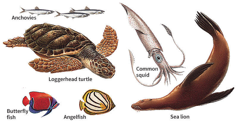
Fish rank among the most important animals of the nekton. About 14,500 kinds of fish live in the ocean. One of the world’s smallest fishes, a goby with the scientific name Trimmatom nanus, lives in the Indian Ocean. It grows to about 0.4 inch (1 centimeter) long. The largest fish, the whale shark, measures as much as 40 feet (12 meters) long. Such fish as tuna and mackerel have streamlined bodies that enable them to swim rapidly through the water. Many fish of the deeper parts of the ocean have light-producing organs that may help attract prey. Such fish include deep-sea anglerfish and lanternfish. 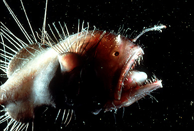
Squids are free-swimming mollusks, a group of soft-bodied invertebrates, and have eight arms and two tentacles. Related animals include octopuses and cuttlefish. Squids live in surface and deep waters. They may measure from less than 1 foot (0.3 meter) to as much as 60 feet (18 meters) long, including the tentacles. A squid moves backward through the water in a jetlike action by forcing water through a tube that lies beneath its head.
Nektonic mammals include dugongs, manatees, porpoises, and whales, all of which remain in the ocean for their entire lives. Other marine mammals, such as sea otters, seals, and walruses, also spend time on land.
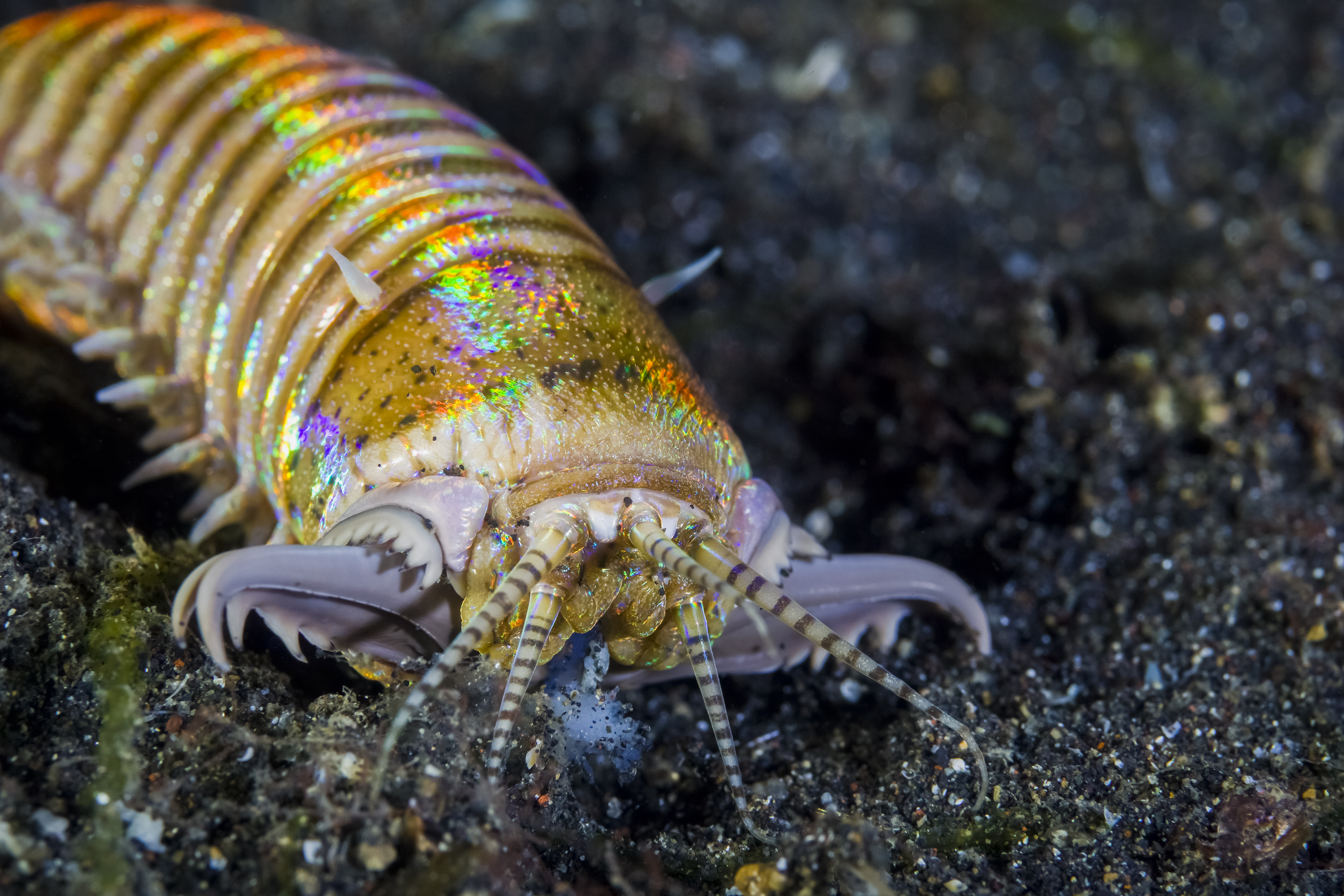
The benthos
is made up of marine organisms that live on or near the sea floor. Animals of the benthos may burrow in the ocean floor, attach themselves to the bottom, or crawl or swim about within the bottom waters. Where sunlight can reach the sea floor, the benthos includes plants and plantlike organisms, such as kelp and sea grass, which become anchored to the bottom. Among the common benthos animals are clams, crabs, lobsters, starfish, and several types of worms. Some fish have features specially suited for life on the ocean floor. For example, halibut and sole, which lie sideways on the bottom, have both eyes on the side of the head facing up. 
Most bottom-dwelling creatures are part of the plankton and drift with the currents during the early stages of their development. They then sink to the sea floor where, as adults, they become part of the benthos. Such animals include barnacles, clams, corals, oysters, and various snails and worms.
The food cycle
in many parts of the sea begins with the phytoplankton that produce food by photosynthesis. Certain zooplankton eat the phytoplankton. Those animals, in turn, become food for other zooplankton or for fish and other animals. 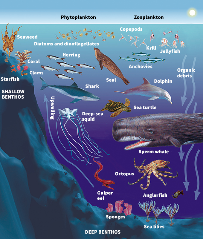
After ocean animals die, they begin to sink. Before most dead animals sink very far, they are eaten by creatures dwelling at lower depths. Animals begin to decay as soon as they die. In addition, animals give off waste products. The waste products—and dead animals that are not eaten—are broken down into mineral salts by bacteria. Rising currents carry the minerals to the surface, where the phytoplankton use them to make food, thus completing the food cycle.
Hydrothermal vents support thriving communities of marine life. However, the food cycle at hydrothermal vents is not based on phytoplankton. Instead, such microscopic organisms as bacteria and archaea serve as the food base. Archaea are single-celled organisms that rank among the oldest forms of life on Earth. In a process called chemosynthesis, these microorganisms use energy from chemicals in the water instead of sunlight to produce food and grow. Other living things rely on archaea for food.
How the ocean moves
Ocean currents move through the sea like giant meandering rivers. Winds and earthquakes create waves across the surface of the ocean. The gravitational pull of the moon and sun causes movement, producing the daily rise and fall of the tides.
Circulation.
Two main types of circulation exist in the ocean. They are (1) wind-driven currents and (2) thermohaline circulation.
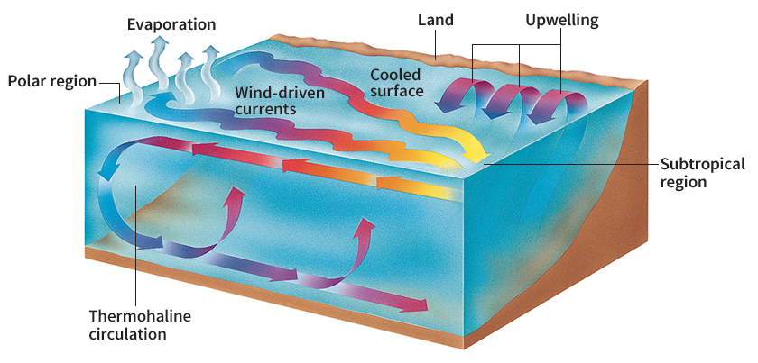
Wind-driven currents
result from wind blowing on the ocean surface. The wind sets surface waters into motion as currents. Currents generally flow horizontally—that is, parallel to Earth’s surface. The wind mainly affects only the upper 330 to 660 feet (100 to 200 meters) of water. However, the flow of wind-driven currents may extend to depths of 3,300 feet (1,000 meters) or more.
Wind-driven currents move in enormous circular patterns called gyres. Gyres flow clockwise in the subtropics of the Northern Hemisphere and counterclockwise in the subtropics of the Southern Hemisphere. Several conditions influence the direction of wind-driven currents and make them form gyres. Earth’s wind systems drive the currents in an easterly or westerly direction. Continents direct the flow toward the north or south. Earth’s rotation further causes the currents’ circular paths. Major wind-driven currents include the North and South Equatorial currents, the California Current, the Canary Current, the Gulf Stream, the Kuroshio (Japan Current), the Labrador Current, and the Peru Current. The Antarctic Circumpolar Current is the strongest ocean current and the only one that circles Earth without hitting continents.
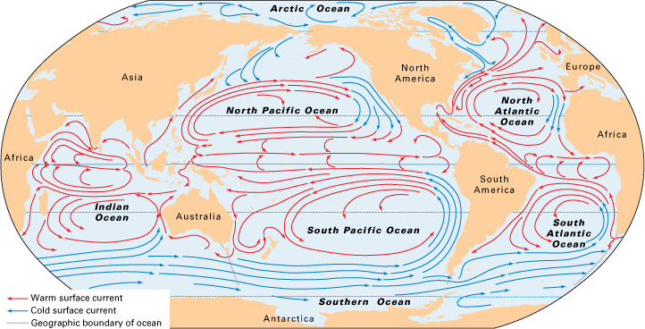
In some areas, upwelling occurs when winds cause surface waters near the coast to move offshore. Colder, deeper waters, which are rich in nutrients, then rise to the surface near the coast. The upwelling of deeper waters provides nutrients for the growth of phytoplankton, which fish and other sea animals eat. Upwelling areas have great numbers of fish and, in fact, yield half of the world’s fish catch. Important upwelling regions include the coasts of Peru and northwestern Africa, as well as along the equator and around Antarctica.
Thermohaline circulation
produces great vertical movements of water that flow from the surface to the ocean depths. The circulation results from differences in water temperature and salinity. In the polar regions, surface waters are colder and saltier. Being colder and saltier makes these waters heavier, and they sink toward the ocean bottom. They then gradually flow back toward the surface and replace the surface waters that sink. 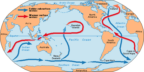
Thermohaline circulation produces a worldwide circuit comparable to a conveyor belt. Cold, dense waters descend from the surface in the North Atlantic and spread southward in deep areas of the ocean. Upon reaching the Southern Ocean, these waters sweep eastward around Antarctica and then spread northward into the Indian and Pacific oceans. In the North Pacific, the waters migrate upward as they become warmer and less saline. They then follow the surface circulation, returning southward into the Indian Ocean and through the southern Atlantic around the Cape of Good Hope. They eventually reach the North Atlantic, where the conveyor belt begins another global circuit. Such waters take about 1,000 years to make one complete circuit.
Waves.
In addition to creating currents, wind is responsible for the up and down movements of an ocean wave. Little or no forward motion of water occurs as a wave goes through the water. The action of an ocean wave resembles waves you can make in a rope that is tied to a tree. If you shake the rope’s free end, waves run along it. But the rope itself does not move forward. When an ocean wave reaches land, however, it starts to drag on the bottom. The wave becomes steeper and breaks, producing a rush of water against the shore called surf. See Waves.
Ocean waves vary in size from small ripples to giant hurricane waves more than 100 feet (30 meters) high. Wave size depends on wind speed, on how long the wind blows, and on how far it blows over the ocean. The waves continue to move over the ocean surface and can travel great distances from where they originated. If the wind stops, the waves become smoother and longer. However, waves created by strong winds in the open ocean may become so steep that they break in a manner similar to surf. These breaking waves are called whitecaps. 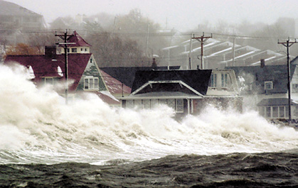
The action of ocean waves changes the shoreline. Waves cut away sloping land and leave steep cliffs. They break up exposed rocks and form beaches. The movement of the waves and currents shapes beaches and builds up sand bars along the shore. Waves also carry beach sand away, particularly during storms.
Another type of wave results from a disturbance such as a submarine earthquake, landslide, or volcanic eruption. Such a disturbance can generate a series of waves called a tsunami. Some people call tsunami waves tidal waves, though the tide does not cause them. On the surface of the open ocean, the waves of a tsunami can barely be seen. The waves typically measure about 3 feet (1 meter) high or less. But they can travel as fast as 600 miles (970 kilometers) per hour. As they approach a coast, they slow down and may pile up to a tremendous height, causing great damage along the coast. Most tsunamis strike land areas in or bordering the Pacific Ocean. Sometimes, scientists can predict when a tsunami may form and warn people in its path. See Tsunami.
Tides
are the rhythmic rise and fall of ocean waters. In many coastal areas, water slowly rises along the shoreline for about six hours every day. Then it slowly falls back for about six hours. Tides are caused chiefly by the gravitational pull of the moon on Earth. The moon’s pull is strongest on the surface of Earth directly facing the moon. When ocean waters face the moon, the moon’s pulls the water up and forms a high tide in that area. The moon’s pull is weakest on the side of Earth opposite from the moon, enabling water there to move away from the earth as it rotates. This action produces another high tide bulge. As Earth rotates each day, high tide bulges move around the planet. Loading the player...
Phases of the moon
The sun’s gravitational pull also affects the ocean. But the sun causes tides only about half as high as those caused by the moon. The gravitational pull of the moon and sun combine during the full moon and new moon. At such times, the sun, moon, and Earth are in a straight line. The tides then rise higher and fall lower than usual. They are called spring tides. When the moon is in its first and third quarters, the sun and moon are at right angles to each other with respect to Earth. The resulting tides do not rise or fall as much as usual. They are called neap tides. See Tide.
The land at the bottom of the sea
The ocean floor is a region of spectacular contrasts. Broad plains cover huge distances, towering mountain chains circle the planet, undersea volcanoes rise toward the surface, and trenches and valleys reach great depths.
The continental margin
forms the part of the seabed that borders the continents. It consists of (1) the continental shelf, (2) the continental slope, and (3) the continental rise.
The continental shelf
is the submerged land at the edge of the continents. It begins at the shoreline and gently slopes underwater to a depth less than 660 feet (200 meters). The width of the continental shelf usually ranges between 19 and 190 miles (30 and 300 kilometers). In certain areas, such as parts of the Arctic Ocean, the shelf extends over 620 miles (1,000 kilometers). In other areas, particularly those bordering much of the Pacific, it measures only 1 mile (1.6 kilometers) or less. Valleys of varying depths cut through the shelf. Sediment carried into the ocean by rivers collects on the shelf.
The continental slope
begins at the outer edge of the shelf. The slope is much steeper than the shelf and plunges to depths of 2.2 miles (3.6 kilometers). The slope forms the sides of continents. Its width ranges from 12 to 60 miles (20 to 100 kilometers). In many places, deep underwater canyons gash the slope. Some canyons rival the gigantic Grand Canyon of North America in size. Many underwater canyons lie offshore from large rivers, and sediment-laden waters may have carved them.
The continental rise
consists of sediment from the continental shelf and slope that accumulates at the bottom of the slope. The thick sediment deposits of the continental rise extend up to about 600 miles (1,000 kilometers) from the slope.
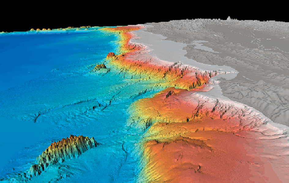
Deep-sea peaks, valleys, and plains
lie beyond the continental margin in the ocean basin. Mid-ocean ridges form a chief feature of the basin. The ridges consist of a chain of mountains that runs through the world ocean. Estimates of the chain’s total length range from 30,000 to 50,000 miles (50,000 to 80,000 kilometers). Scientists discovered the mountain chain independently in each ocean basin and gave it different names, including Mid-Atlantic Ridge, East Pacific Rise, and Mid-Indian Ridge. Most mountains of the mid-ocean ridges stand about 5,000 feet (1,500 meters) above the sea floor. Some peaks rise above the surface and form islands, such as the Azores and Iceland in the Atlantic Ocean. Deep valleys cut across the ridges in many places, producing a rugged, fractured surface. Some mid-ocean ridges have valleys down through the center of them. Frequent volcanic eruptions and earthquakes occur along such valleys.
The sides of the mid-ocean ridges slope down to the abyssal plains. Accumulation of sediment buries most features of the ocean floor on the abyssal plains, which are flat as a result. The chief sources of deep-sea sediment are the land itself and marine life. The breaking down and wearing away of rock produces land sediment, which rivers carry to the ocean. Wind also carries dust from deserts and other regions to the ocean. In addition, volcanic eruptions spread large amounts of ash over the ocean. Marine life sediment consists mainly of tiny shells and the remains of dead planktonic organisms. When such biological matter makes up a major part of a sediment, scientists call it an ooze (see Ooze).
Other features of the deep-sea basin include the long, narrow trenches and underwater mountains called seamounts. Trenches form the deepest parts of the ocean. Volcanic eruptions produce seamounts. These mountains have steep sides and may rise thousands of feet or meters above the sea floor.
How the sea floor was formed.
Since the late 1800’s, scientists have developed several theories to explain how the sea floor was formed. The theory of continental drift first received wide attention during the early 1900’s. According to this theory, the continents originally consisted of a single great land mass surrounded by one ocean. The mass broke up into continents, which slowly drifted apart. New oceans, including the Atlantic and the Indian oceans, resulted from the drift of the continents.
At first, many scientists rejected the continental drift theory because no one could explain what forces might move continents. Then in the 1960’s, a theory called sea-floor spreading provided some explanation. According to the theory, the sea floor itself moves, carrying the continents along. Circulating movements deep within Earth’s mantle—that is, the partly molten layer of hot rock beneath Earth’s crust—make the sea floor move. The circulating movements carry melted rock up to the mid-ocean ridges and force it into the central valleys of the ridges. As the melted rock cools and hardens, it forms new sea floor and pushes the old floor and the continents away from the ridges.
The most recent theory, called plate tectonics, combines and expands on the ideas of sea-floor spreading and continental drift. According to plate tectonics, Earth’s outer shell consists of huge rigid plates that move continuously. As the plates move, they carry the ocean floor and the continents with them. The relative movement of two neighboring plates is generally about 0.5 to 4 inches (1 to 10 centimeters) a year. Sea-floor spreading—and the formation of new sea floor—occurs where plates move apart. The mid-ocean ridges mark such areas.
As plates move away from one another in one place, they must move toward one another elsewhere. When two plates collide, one may pile up against the other, forming mountains. Or one plate may be drawn down into the mantle under the other plate. Such action produces trenches and volcanoes. Earthquakes occur at or near plate boundaries, where plates spread apart, collide, or slide past each other. The Atlantic Ocean is slowly growing wider, and the Pacific smaller, because of plate tectonics. See Plate tectonics.
The oceanic crust forms the ocean floor. It consists of hard rock called basalt. The continents lie on the continental crust, which consists mainly of granite. Granite is lighter than basalt, and so the continental crust basically “floats” on the mantle, above the oceanic crust. Ocean basins, as sunken areas, thus collect water. The water that now fills the oceans came from a number of asteroids and comets that struck Earth as it formed nearly 4.6 billion years ago. Much of it was released from rocks within Earth by volcanic activity.
Exploring the ocean
By exploring and understanding the ocean, we can learn to manage its resources wisely.
Tools of exploration.
The tools that oceanographers use in their efforts to explore the sea include (1) research ships, (2) research submarines called submersibles, (3) satellites, and (4) computers.
Research ships
typically measure about 100 to 300 feet (30 to 90 meters) long and include laboratory space where scientists can work while at sea. Oceanographers use research vessels to make measurements, perform experiments, and study marine processes. They may stay at sea for weeks or months at a time. They often work in rough seas and in distant locations around the world.
Oceanographers use several types of instruments on research ships. They operate underwater cameras to photograph the sea floor. Electronic devices measure the depth of the sea by sending out sound waves and recording their echoes from the ocean floor. The most powerful of such instruments detect echoes from deep within Earth’s crust. Scientists analyze the records to learn about the structure of the crust. Oceanographers also use devices to measure temperature, salinity, and a wide array of chemicals in the ocean. Nets towed behind research ships gather samples of marine life for study.
Oceanographers also use a number of floating devices. For example, a mooring consists of an anchor and a float connected by a cable. The float may be placed at the sea surface or at a specific depth. Scientists attach various instruments to the cable of a mooring. Some instruments measure the speed and direction of ocean currents at different depths. Other devices record the temperature and salinity of the water. A mooring may remain at sea several years before the research ship picks up the device and the data it has collected.
Other floating devices include buoys, which drift with the ocean’s surface currents. Buoys chiefly provide information about ocean circulation. However, they may also record air pressure or surface water temperature. Buoys relay data to scientists through orbiting satellites. Certain buoys can drift with currents below the ocean surface.
Oceanographers use specialized equipment to collect samples from the ocean bottom. Scientists can gather rock samples from the mid-ocean ridge by towing a scooping machine called a dredge along the sea floor. Other ships can drop long, heavy pipes into the sea floor to collect vertical samples of sediments called cores. Since sediments are deposited in layers over time, studies of cores can determine how old the sediments are. The age and composition of the sediments can reveal how oceans have changed over time. See Ocean drilling programs.
Submersibles
can descend to the depths of the ocean. They enable scientists to observe features on the sea floor that may be missed by instruments lowered from research ships on the surface.
Piloted submersibles, such as the Alvin, carry a human crew. The crew members take photographs and use a mechanical arm outside the vessel to gather samples and set out instruments. 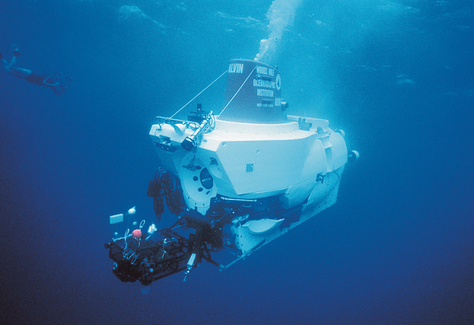
Other submersibles, called remotely operated vehicles (ROV’s) or autonomous underwater vehicles (AUV’s), carry no crew. ROV’s usually are controlled from a ship by a cable. They have television cameras and sensors that can return information about the sea floor environment. In 1985, two remotely operated submersibles—the U.S. Argo and the French Sar—found and explored the wreckage of the Titanic, a British passenger ship that sank in the Atlantic in 1912. AUV’s are self-contained vehicles controlled by an onboard computer programmed with instructions. They can explore specific areas of the ocean, take measurements, and collect samples. AUV’s return to the control ship or station to recharge batteries, return data and samples, and receive new instructions in their computers. See Diving, Underwater.
Satellites
transmit data from buoys and other instruments at sea to oceanographers on shore. They also provide views of vast expanses of the sea from their position high above Earth. In general, satellites supply information more quickly over a larger area than do research ships.
Satellite images can show the distribution of sea ice, the extent of surface oil slicks, and the cloud formations over the ocean. Satellites can help map the temperature and color of the ocean surface. Some satellites can even detect the small differences in the elevation of the sea surface caused by ocean currents. Such data help oceanographers in many ways. For example, scientists can study variations in the routes and patterns of ocean currents and their effects on climate and weather. Researchers can also determine biological activity in the ocean’s surface waters, as well as understand how the ocean affects weather and climate.
Computers
enable oceanographers to collect and analyze the enormous amounts of data obtained every day from satellites, from instruments on research ships, and from buoys. Scientists also use computers to create models (mathematical representations) of the ocean’s movement and structure. The models enable them to understand and predict the ocean’s behavior and its effect on the environment.
Discoveries.
Oceanographers constantly make new and interesting discoveries about the sea. One of the exciting discoveries occurred in 1977, when scientists first detected a hydrothermal vent on the sea floor near the Galapagos Islands in the eastern Pacific Ocean. Similar vents have been found elsewhere in the ocean, especially along mid-ocean ridges, volcanic regions where new sea floor forms as tectonic plates move apart. Hydrothermal vents occur at a range of depths, from the shallow water around volcanic islands to more than 12,000 feet (3,600 meters) beneath the ocean’s surface.
Hot seawater containing such chemicals as copper, iron, manganese, zinc, and sulfate flows from the vents. As the hot water mixes with colder seawater containing oxygen, chemical reactions form dark-colored mineral particles. These particles produce deposits around the vents. The deposits take the shape of “chimneys” through which the water shoots out. The dark-colored minerals make the water look like black smoke, and so these hydrothermal vents are called black smokers. 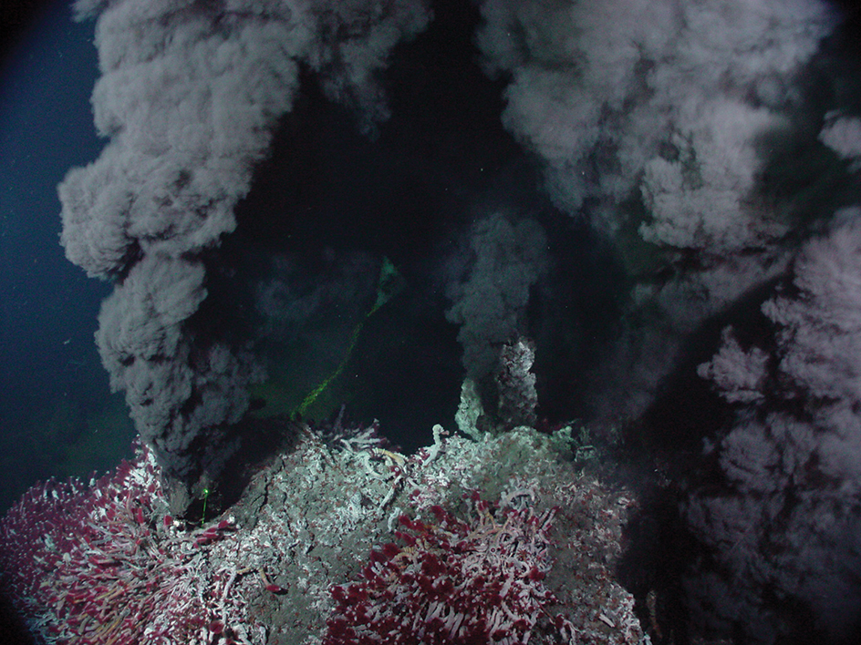
Communities of strange marine life live at hydrothermal vents. Scientists discovered that some kinds of bacteria and archaea that live there use chemosynthesis to produce food. Such organisms serve as the base of the food chain for the vent communities. Scientists previously thought that all food chains throughout the ocean began with the energy from sunlight and the photosynthesis that takes place in shallow waters. Other forms of life found near hydrothermal vents include clams up to 1 foot (30 centimeters) long and giant tubeworms up to about 5 feet (1.5 meters) long. Scientists have also discovered various species of crabs, fish, shrimp, and other animals in the vent communities. Most of the animals were previously unknown species of marine life.
Oceanographers often make discoveries as they apply new instruments and techniques to study the ocean. The use of specialized research ships, satellites, and computers has increased their understanding of oceanic processes. For example, such technology has enabled us to better understand the effects of El Niño in Earth’s weather and climate systems. El Niño is an interaction between the atmosphere and the waters of the Pacific Ocean that occurs about every two to seven years. During an El Niño, a warm current flows southward along the west coast of South America, warming the normally cold coastal waters of Ecuador and Peru. The warming of the ocean waters kills many fish and the sea birds that rely on fish for food. A typical El Niño lasts approximately 18 months. 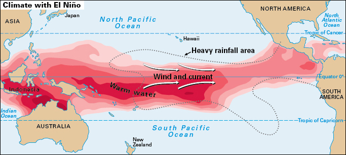
For years, El Niño was considered only a local phenomenon. In the 1960’s, however, scientists observed a connection between El Niño and a change in the normal trade winds over the tropical Pacific Ocean. In the 1990’s, oceanographers used a variety of ships, satellites, and electronic instruments to study the ways in which the tropical ocean and atmosphere interact to produce El Niño events. They discovered that El Niño and the opposite pattern called La Niña that often follows are part of a larger atmospheric pattern known as the Southern Oscillation. El Niño studies have also enabled scientists to predict El Niño events—and their effects—from 6 to 18 months in advance. These effects include rainfall and drought conditions, as well as severe forest fires and floods. See El Niño. 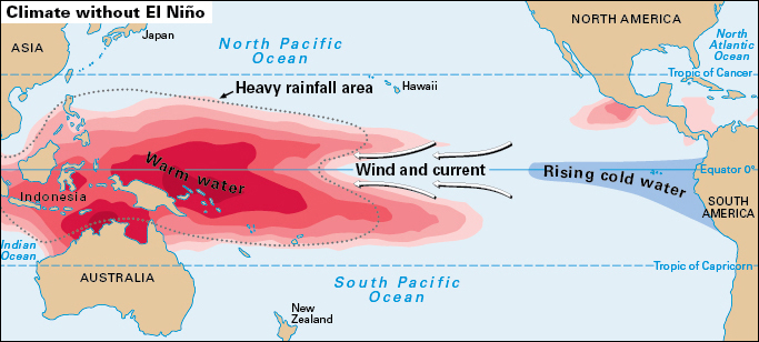
International cooperation.
Increasingly, many countries now cooperate with one another in conducting scientific studies of the ocean. Major international investigations have studied such issues as the circulation of ocean waters, the changes in sea’s chemical content, and the structure of marine ecosystems. In addition, efforts are underway to develop a global ocean observing system to better understand natural and human-induced changes in the marine environment.
Ocean problems
For thousands of years, people used the ocean and its vast resources with little concern for their conservation. But during the last two centuries, increases in human population, industrial development, and use of coastal regions has put the health of the sea at risk, forcing people to address ocean conservation problems. Many of the most important problems involve marine pollution, depletion of fisheries, habitat modification, and climate change.
Marine pollution.
Pollutants (substances that cause pollution) enter the ocean through accidents, carelessness, and the deliberate disposal of wastes. The ocean can absorb some types of pollutants in certain quantities because of its great size and the natural chemical processes that occur within it. But the ocean’s capacity to absorb and recycle pollutants can become overwhelmed.
People pollute the oceans in several ways. Major ocean pollutants include waste products, which people often dump deliberately into the ocean, and oil, which usually enters the sea by accident.
Waste products
that enter the ocean include sewage, plastic litter, and industrial wastes. Sewage, such as human waste and ground-up garbage, often fouls coastal regions. This kind of waste contains organic matter that decomposes and reduces the levels of oxygen in the water. Low oxygen levels make the water unfit for animals. Sewage also contains nitrates, phosphates, and other nutrients that stimulate the growth of phytoplankton. An overabundance of certain phytoplankton produces a condition called eutrophication, which also reduces the water’s oxygen levels. Rapid growth of some phytoplankton can create red tides. Red tide phytoplankton produce toxins that poison marine life.
Plastic litter can severely damage the ocean because it does not break down easily. Sea birds, turtles, seals, whales, and other marine animals can get tangled in plastic nets, bags, and packing material. These animals may also mistake plastic items for food and die of starvation if the plastic blocks their digestive system. In addition, plastics and other litter make the marine environment less attractive. Many countries ban the disposal of plastics into the ocean, but such litter remains a common problem on shorelines.
The deliberate dumping of industrial waste into the sea from ships and barges has also polluted oceans. Such wastes have included ash from power plants, contaminated sediments dredged from harbors, and even radioactive wastes. Since the 1970’s, many countries have begun banning ocean dumping of most wastes. But the disposal of some types of wastes, such as dredged sediments, may likely continue.
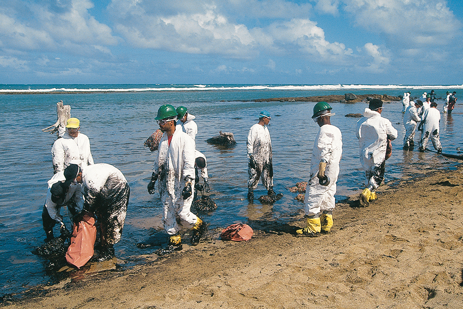
Oil pollution
enters the ocean from oil spills on land or in rivers. Oil also seeps into the ocean naturally from cracks in the sea floor. Oil tanker and oil well accidents at sea can cause disastrous effectsthat last for decades. One of the largest accidental oil spills in history occurred in 2010, when an explosion on an offshore oil rig caused about 200 million gallons (760 million liters) of oil to spill into the Gulf of Mexico. The world’s largest oil spill occurred when Iraq deliberately released well over 200 million gallons of oil into the Persian Gulf during the Persian Gulf War of 1991. In water, the oil can break apart, spread, and sink. It can thus pollute distant beaches and other coastal areas, as well as the ocean floor. Oil also coats fish, birds, and mammals and kills many of them.
Fisheries.
Since the latter part of the 1900’s, the world’s fishing industry has harvested fish from many ocean fisheries faster than the fish stocks can renew themselves. Some fishing techniques have proved especially destructive. These techniques include the use of dynamite and cyanide to stun or kill fish on coral reefs. They also include the use of nets that capture, injure, or kill species other than the ones being sought. In some cases, the depletion of commercially valuable fish species can alter marine ecosystems by making less valuable species more abundant. Such problems have led many countries to enforce limits on catch and even temporarily close a number of valuable fisheries.
Habitat modification.
People have harmed marine ecosystems in many coastal regions by destroying such vital habitats as marshes; mangrove swamps, where the spreading roots of mangrove trees catch and hold silt from the water; and tidal flats, which are covered and uncovered twice daily by the tides. These environments often play an essential role in maintaining a healthy marine ecosystem. As a result, conservationists are attempting to stop further damage to such habitats and, in some cases, to restore the habitats to their natural state.
Climate change.
Natural processes cause most kinds of climate change. But increasing evidence indicates that human activities can also produce changes in climate. Over the past 150 years, the combustion of such fossil fuels as petroleum, coal, and natural gas has increased the amount of carbon dioxide gas in the atmosphere by about 30 percent. Carbon dioxide traps heat from the sun in a process called the greenhouse effect. Increases in atmospheric carbon dioxide may enhance the greenhouse effect and significantly raise temperatures on Earth. Such changes in climate could greatly affect all marine ecosystems. See Greenhouse effect.
Scientists are working to determine the role of the ocean in climate, as well as the effects of human activities on climate change. Scientists have studied the possibility of disposing carbon dioxide into the depths of the ocean as a way to keep Earth from overheating.
Who owns the ocean?
This question has become more important as countries have learned that fish and other ocean resources can be used up and that valuable minerals and sources of energy lie on and under the sea floor. The United Nations has worked to develop an agreement on ownership of the sea. Its efforts resulted in the Law of the Sea Convention, drafted in 1982. This treaty went into effect in 1994, after more than 60 nations ratified it. The treaty provides for a system to protect the economic and environmental interests of coastal nations, while allowing the free passage of other countries’ ships.
Under the Law of the Sea Convention, the laws of a coastal nation apply throughout its territorial sea, which extends 12 nautical miles (22 kilometers) from the nation’s shoreline. An exclusive economic zone (EEZ) lies beyond the nation’s territorial sea and extends, in most cases, 200 nautical miles (370 kilometers) from the nation’s shoreline. Each coastal nation, even if it is an island, has total control over resources and research within its EEZ. The remaining ocean area is defined as the high seas, where no nation may make a territorial claim. However, even on the high seas, various international agreements govern fishing methods and fishing catches, as well as disposal of wastes.
The United States has not joined the Law of the Sea Convention. At the time the treaty was drafted, the U.S. government supported most of its provisions but believed it did not adequately protect private industries involved in deep-sea mining operations. In 1994, the United States signed an agreement that addressed these deep-sea mining concerns. However, the U.S. Senate has not approved the 1994 agreement or the original convention.
Careers in oceanography
The ocean can be studied in many ways, and the science of oceanography includes several specialties. Physical oceanographers study waves, tides, currents, and the action of the ocean and the atmosphere on each other. Chemical oceanographers study the chemical reactions that occur in the ocean. Marine geologists and marine geophysicists analyze the form and composition of the sea floor, as well as the forces that shape the ocean floor. Marine geologists mainly study the sediments and surface features of the ocean bottom. Marine geophysicists deal with the deeper oceanic crust. Biological oceanographers and marine biologists study marine life, from microscopic bacteria to large marine mammals. Ocean engineers design instruments to study the ocean, develop methods for obtaining minerals and other resources from the sea, and design structures for use in the ocean and on the sea floor. 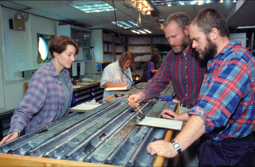
To become an oceanographer, one needs a background in science and mathematics. Solid knowledge of at least one basic science, such as biology, chemistry, geology, or physics, is required. Most oceanographers acquire detailed knowledge of oceans through graduate training.
An oceanographer may choose from several types of careers after completing training. Research jobs are available at colleges and universities, at oceanographic institutions, in government, and in industry laboratories. Colleges and universities also provide teaching jobs. Some oceanographers go on long research expeditions or make deep-sea dives. Others formulate theories or interpret scientific observations. Oceanographers may also work with computers in an attempt to re-create, analyze, and predict ocean behavior.
