Pacific Ocean is the largest body of water in the world. The ocean covers about 66 million square miles (171 million square kilometers). That area represents over 45 percent of the total area of all the oceans and about one-third of Earth’s total surface area. Thousands of islands lie in the Pacific Ocean. They range from island nations, such as Japan and New Zealand, to the hundreds of small, scattered islands in the central and southern Pacific. The Pacific Ocean is a source of many natural resources, including seafood, petroleum, and minerals.
The word pacific means peaceful. The ocean received this name from the Portuguese explorer Ferdinand Magellan, after he emerged from the rough seas south of South America into calm ocean waters. But the Pacific is often far from peaceful. Typhoons and hurricanes in the Pacific have wrecked fleets of ships and destroyed island cities. Earthquakes and volcanic eruptions deep in the sea can create a series of destructive waves called a tsunami << tsoo NAH mee >> In the open ocean, tsunami waves are hardly noticeable because of their small height. When the waves reach the shore, however, the waters can pile up to a height of more than 100 feet (30 meters).
In 1513, the Spanish explorer Vasco Núñez de Balboa crossed the Isthmus of Panama and became the first European to see the eastern Pacific. Magellan was the first European to sail across the ocean. He crossed it from November 1520 to April 1521. In the 1760’s and 1770’s, Captain James Cook of the British Navy explored and mapped much of the Pacific. He probably was the first European to visit the Hawaiian Islands, Australia, and New Zealand.
Boundaries.
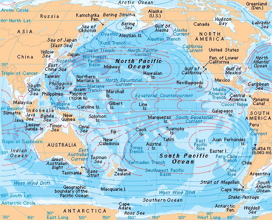
The Bering Strait between Russia and Alaska marks the northern end of the Pacific Ocean. The eastern border of the Pacific Ocean is North and South America. To the west lie the mainland of Asia and the countries Indonesia and Australia. The southern limit of the Pacific is the line of 60° south latitude. South of that line is the Southern Ocean, also known as the Antarctic Ocean.
A number of seas, called marginal seas, are part of the Pacific Ocean. Those include the Bering Sea, the Sea of Japan (also called the East Sea), the East China Sea, and the Tasman Sea.
The ocean floor.
The depth of the Pacific Ocean varies greatly from place to place. On the ocean floor are high mountains, ridges, vast plains, and extremely deep areas called trenches.
One underwater mountain range, the East Pacific Rise, extends from north of Antarctica to the coast of Mexico. The height of the East Pacific Rise above the ocean floor varies from about 6,500 to 10,000 feet (2,000 to 3,000 meters). In many parts of the Pacific, volcanic eruptions have created peaks called seamounts. Some seamounts rise above the surface of the water, forming islands.
The deepest parts of the Pacific Ocean are in the trenches. Most of the trenches are from 20,000 to 30,000 feet (6,000 to 9,000 meters) deep. The Mariana Trench, near Guam, includes the Challenger Deep, the deepest known spot in any ocean. The Challenger Deep extends about 36,070 feet (10,994 meters) below the water’s surface.
In the eastern Pacific, minerals from hydrothermal vents build up to form chimneylike structures. Hydrothermal vents occur as a result of ocean water seeping down through cracks in the sea floor. Underlying rock heats the water, which then rises back to the ocean floor to create mineral-rich springs.
A shallow region of ocean floor called a continental shelf extends off the shore of each continent bordering the Pacific. The water on the continental shelves is usually less than 660 feet (200 meters) deep.
Climate.
The North Pacific has long, cold winters and short, cool summers. Along the equator, the climate is hot all year. In much of the South Pacific, summers are mild, and winters are cool. In the southernmost part of the Pacific, winters are cold and stormy.
Winds
over the Pacific include the trade winds and the prevailing westerlies. In both the Northern and Southern hemispheres, the trade winds blow from about 30° latitude toward the equator. They come out of the northeast in the Northern Hemisphere and out of the southeast in the Southern Hemisphere. The prevailing westerlies blow from the west between the latitudes of 30° and 60° in both hemispheres. They produce stormy belts of precipitation at about 60° and areas of little precipitation at about 30°. See Trade wind; Prevailing westerly.
Tropical cyclones
are great circular winds that produce much of the rainfall in the Pacific area. They usually cause little or no damage, and they may bring needed rain to dry areas. However, they occasionally reach such high speeds that they become destructive. A tropical cyclone whose speed reaches 74 miles per hour (119 kilometers per hour) is called a hurricane in the Northeast Pacific, a typhoon in the Northwest Pacific, and a severe tropical cyclone in the Southwest Pacific. See Cyclone; Hurricane; Typhoon.
El Niño.
About every two to seven years, a climate change occurs in the Pacific between 20° north latitude and 20° south latitude. In normal times, the trade winds blow the surface waters from east to west. In the east, deeper cold water rises to the surface to replace the water that is blown away. The cold water is rich in nutrients that increase the growth of the plankton—a mass of tiny animals and plantlike organisms that drift with the currents. The plankton, in turn, supports a huge population of fish. As a result, the waters off Ecuador and Peru are one of the world’s largest commercial fishing areas.
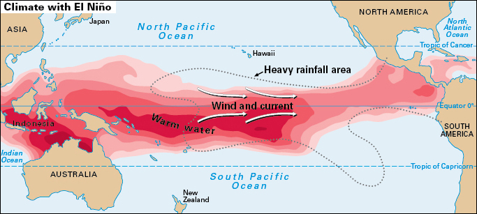
When the climate changes, the east-to-west winds weaken or may even reverse. As a result, the waters off Ecuador and Peru become abnormally warm. Cold, nutrient-rich water no longer rises to the surface, so the fish population declines sharply.
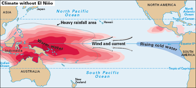
The interaction of the atmosphere and the ocean during this abnormal period is known as an El Niño. During an El Niño, the coast of South America becomes wetter than normal, and the climate in Indonesia and other nations of Southeast Asia is unusually dry. An El Niño usually begins in the early summer of one year and extends into the spring of the next year.
An opposite effect called La Niña can also occur. During a La Niña, the water in the eastern Pacific, for example, is cooler than it is when there is merely no El Niño.
Both El Niño and La Niña are part of a larger atmospheric pattern known as the Southern Oscillation. Oceanic and atmospheric scientists now refer to El Niño as the ENSO (El Niño-Southern Oscillation). See El Niño.
Currents.
The surface currents in most of the Pacific Ocean are parts of two gigantic, rotating systems of current known as gyres. One gyre is centered at about 30° north latitude and rotates clockwise. The other is centered at about 30° south latitude and rotates counterclockwise. Trade winds and prevailing westerlies drive both gyres.
In the Northern Hemisphere, the North Equatorial Current carries warm water from Central America west to the Philippine Sea. There, the gyre turns north as the Kuroshio, or Japan Current, which warms Japan. The North Pacific Current travels east across the ocean and warms western Canada.
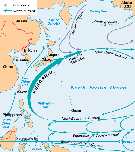
In the Southern Hemisphere, the warm South Equatorial Current flows from South America to about the Solomon Islands. From there, the East Australian Current carries warm water south along the coast of Australia and to New Zealand. The Peru Current, also called the Humboldt Current, carries cool water north along the coast of South America to about Ecuador and Peru.
Water masses.
Beneath the ocean surface are water masses, layers of water with different patterns of circulation. The North Pacific Intermediate Water forms near the surface in the northwestern Pacific. The water becomes cold and dense, so it sinks to greater depths. At depths of 1,600 to 2,600 feet (500 to 800 meters), it spreads out. The North Pacific Intermediate Water flows south to about the equator.
The Antarctic Intermediate Water forms near the southern boundary of the Pacific. It extends northward to about the equator at depths of 1,300 to 4,000 feet (400 to 1,200 meters). The Antarctic Intermediate Water also pushes into the Atlantic and Indian oceans.
Beneath the two intermediate layers is the Pacific Deep Water, whose depth ranges from about 5,000 to 11,000 feet (1,500 to 3,400 meters). This layer moves from north to south throughout the Pacific. The deepest layer is the Pacific Bottom Water. This mass enters the Pacific from the Southern Ocean and flows northward to the northeast Pacific.
Tides.
Large tides occur along the Pacific rim. Some of the largest form off the west coast of Korea. There, the water is 15 to 30 feet (4.6 to 9.0 meters) deeper at high tide than at low tide. In mid-ocean, tides are small. For example, at Midway Island, the water level varies by about 1 foot (0.3 meter). See Tide.
Ocean life.
The oceans contain a complex food web that involves plankton; bacteria; fish; marine mammals, including seals, dolphins, and whales; and animals that live on the seafloor. Seaweeds grow on the seabed in shallow waters. In the tropics, coral reefs support a diverse ecosystem.
An upwelling of water from depths of about 160 to 650 feet (50 to 200 meters) provides nutrients that support ocean life. The cooler subsurface waters are rich in chemical elements and compounds that serve as food for phytoplankton (plantlike plankton). Zooplankton (planktonic animals) feed on the phytoplankton. Fish, in turn, eat the zooplankton. The major areas of upwelling in the Pacific lie along the coasts of North and South America.
Clams and mussels almost 1 foot (0.3 meter) long and giant tubeworms up to about 5 feet (1.5 meters) in length live near hydrothermal vents. Also living in those areas are species of crabs, fish, and shrimp that are found nowhere else.
Resources.
The Pacific provides about half the world’s catch of fish and shellfish. Fishing crews in the Pacific harvest about 50 million tons (45 million metric tons) of seafood annually. Nearly half of the catch comes from the northwest Pacific—near China, Japan, and Russia. Other major fishing areas include waters near Southeast Asia, Australia, South America, and North America.
Other products of the Pacific include pearls, seaweed used for fertilizer and in processed foods, tropical fish for aquariums, and minerals. An important source of seafood along the Pacific rim is fish farming, also called aquaculture or mariculture. Farmers raise fish, shellfish, and seaweeds near ocean shores as well as in ponds.
Prospectors have discovered major deposits of petroleum in coastal waters off California, Southeast Asia, and Australia. Offshore oil wells operate in those waters. Natural gas comes from wells on the continental shelves near Russia, Southeast Asia, and Australia.
On the Pacific seafloor are potentially valuable chunks of material known as manganese nodules. The nodules are shaped like slightly flattened balls, and most are 2 to 4 inches (5 to 10 centimeters) in diameter. They are about 15 to 30 percent manganese, a metal that is used in the manufacture of steel. The nodules are also 5 to 20 percent iron, and they contain significant amounts of nickel, copper, and cobalt.
Scientific research.
Between 1872 and 1876, oceanographers aboard the British scientific ship Challenger became the first to study the ocean floor thoroughly. The researchers obtained samples of deep-sea organisms and seabed materials from the Pacific and other areas. They also measured the depth of the seafloor by lowering ropes to the bottom. Scientists continued to measure depth in that way until the early 1900’s. At that time, they began to use sonar, a process that utilizes sound waves to measure distance.
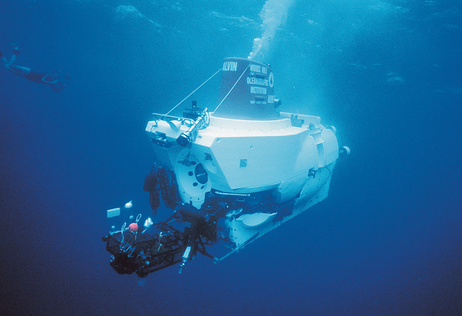
In 1960, Donald Walsh of the United States Navy and Jacques Piccard, a Swiss oceanographic engineer, descended about 35,800 feet (10,910 meters) to the bottom of the Mariana Trench aboard a bathyscaph (diving craft) named Trieste. In 2012, the Canadian-born filmmaker James Cameron made the same trip in the Deepsea Challenger. These dives were the deepest ever recorded. The American explorer Victor Vescovo broke that record in 2019, when his submarine Limiting Factor descended 35,853 feet (10,927 meters) to the bottom of the Mariana Trench. In the mid-1970’s, geochemists conducted an extensive study of the properties of the intermediate, deep, and bottom waters of the oceans. In 1977, scientists aboard the research submersible Alvin made the first discovery of a hydrothermal vent. They found the vent on the Galapagos Rift west of Ecuador.
In the 1990’s, extensive studies of the Pacific and the other oceans continued. One of the largest was part of an international project called the World Ocean Circulation Experiment (WOCE). Two major goals of WOCE were (1) to develop and test computer models useful for predicting climate change and (2) to develop methods for monitoring long-term changes in ocean circulation. A computer model is a set of mathematical equations processed by computers. In this case, the equations simulate (represent) how climate changes.
Scientists want to develop such models to learn more about why the temperature of the air at Earth’s surface is becoming warmer. Continued warming could cause environmental and economic damage.
Most of the warming is almost certainly due to human activities, mainly the burning of fossil fuels (coal, oil, and natural gas). The burning releases carbon dioxide (CO2) gas into the atmosphere. Atmospheric CO2 can increase the surface temperature via a complex process known as the greenhouse effect. Researchers are studying the oceans because the oceans absorb atmospheric CO2. See Global warming; Greenhouse effect.
Damage to reefs.
Global warming may already be damaging coral reefs. An increase in air temperature raises ocean temperatures, and coral reefs are sensitive to a warming of the water.
A coral reef consists of a mass of the limestone skeletons of small animals called polyps, a layer of live polyps attached to the mass and to one another, and algae that live in the polyps’ tissue. The algae produce and release substances that serve as food for the polyps. The algae also give coral reefs their distinctive colors.
But when the water becomes unusually warm, the polyps release their algae. As a result, the polyps turn white; they are said to be bleached. If the water temperature does not return to normal soon enough, the polyps will die. See Coral reef.
Offshore pollution
has harmed creatures that live in the Pacific Ocean. Pollutants flow into the ocean from the land and rivers. The pollutants include industrial chemicals, petroleum products, sewage wastes, and artificial fertilizers. Some of those substances contain nutrients and increase the growth of algae in the ocean. Bacteria break down other substances in the water, releasing nutrients.
Even when little or no pollution is present, algae can accumulate into thick layers called blooms. Certain algae in the blooms can produce poisons that harm other marine organisms. Those substances can also harm people who eat them in seafood.
Many scientists think that nutrients in polluted water cause algae to multiply rapidly, creating extremely thick blooms often called red tides. As a result, the poisons can build up to dangerous levels. In the Pacific, huge blooms have occurred near Japan and China. See Water pollution.
