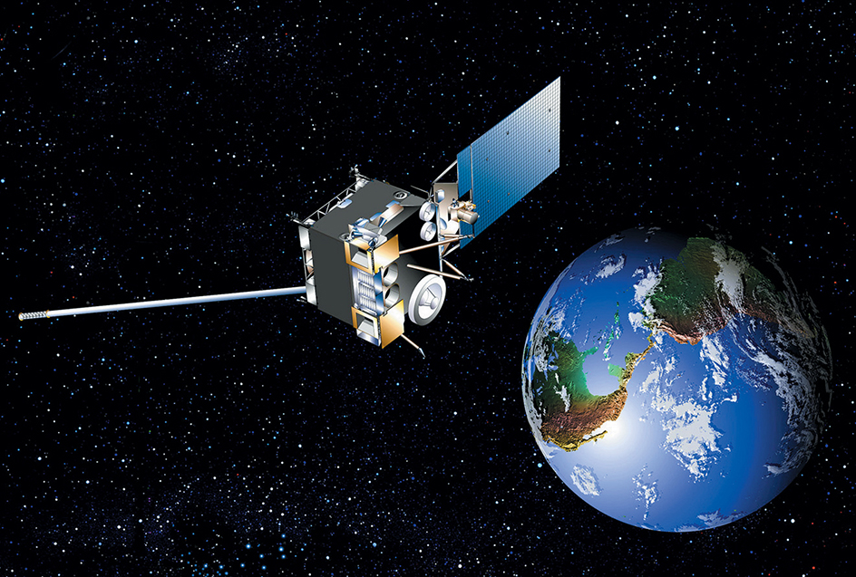
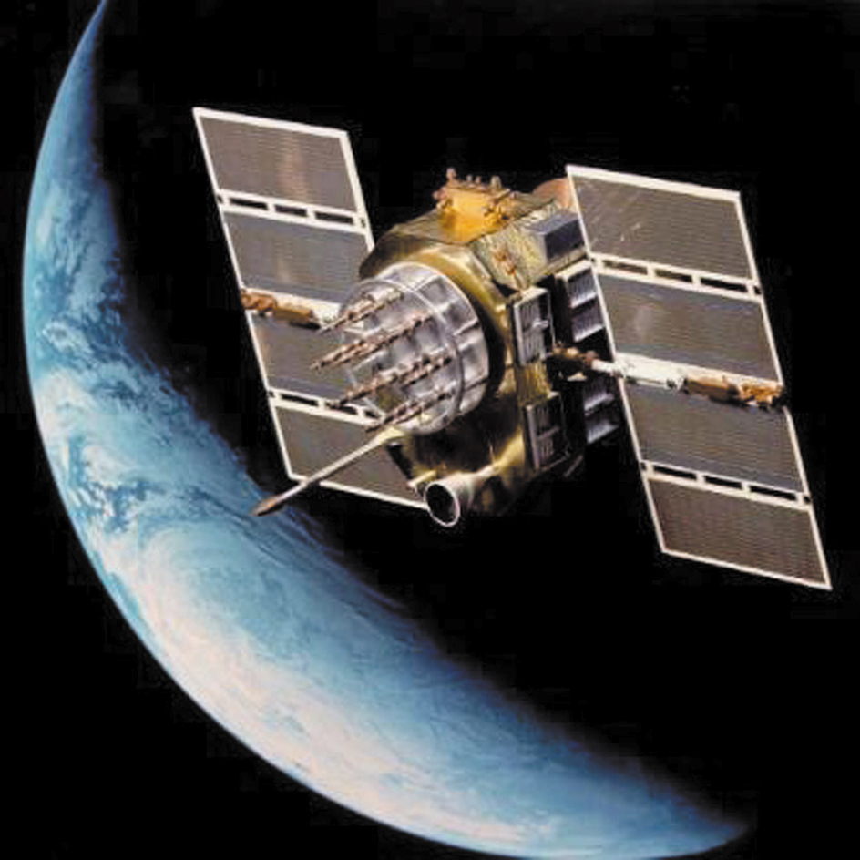
Satellite, Artificial, is a manufactured object that continuously orbits Earth or some other body in space. Most artificial satellites orbit Earth. People use them to study the universe, help forecast the weather, transfer telephone calls over the oceans, assist in the navigation of ships and aircraft, monitor crops and other resources, and support military activities.
Artificial satellites also have orbited the moon, the sun, asteroids, and the planets Venus, Mars, and Jupiter. Such satellites mainly gather information about the bodies they orbit.
Piloted spacecraft in orbit, such as space capsules, space shuttle orbiters, and space stations, are also considered artificial satellites. So, too, are orbiting pieces of “space junk,” such as burned-out rocket boosters and empty fuel tanks that have not fallen to Earth. But this article does not deal with these kinds of artificial satellites. For information on piloted spacecraft, see Space exploration.
Artificial satellites differ from natural satellites, natural objects that orbit a planet. Earth’s moon is a natural satellite. See Satellite.
The Soviet Union launched the first artificial satellite, Sputnik 1, in 1957. Since then, the United States and about 40 other countries have developed, launched, and operated satellites. Today, more than 8,000 working satellites orbit Earth.
Satellite orbits
Satellite orbits have a variety of shapes. Some are circular, while others are highly elliptical (egg-shaped). Orbits also vary in altitude. Some circular orbits, for example, are just above the atmosphere at an altitude of about 155 miles (250 kilometers), while others are more than 20,000 miles (32,200 kilometers) above Earth. The greater the altitude, the longer the orbital period—the time it takes a satellite to complete one orbit.
A satellite remains in orbit because of a balance between the satellite’s velocity (speed at which it would travel in a straight line) and the gravitational force between the satellite and Earth. Were it not for the pull of gravity, a satellite’s velocity would send it flying away from Earth in a straight line. But were it not for velocity, gravity would pull a satellite back to Earth.
To help understand the balance between gravity and velocity, consider what happens when a small weight is attached to a string and swung in a circle. If the string were to break, the weight would fly off in a straight line. However, the string acts like gravity, keeping the weight in its orbit. The weight and string can also show the relationship between a satellite’s altitude and its orbital period. A long string is like a high altitude. The weight takes a relatively long time to complete one circle. A short string is like a low altitude. The weight has a relatively short orbital period.
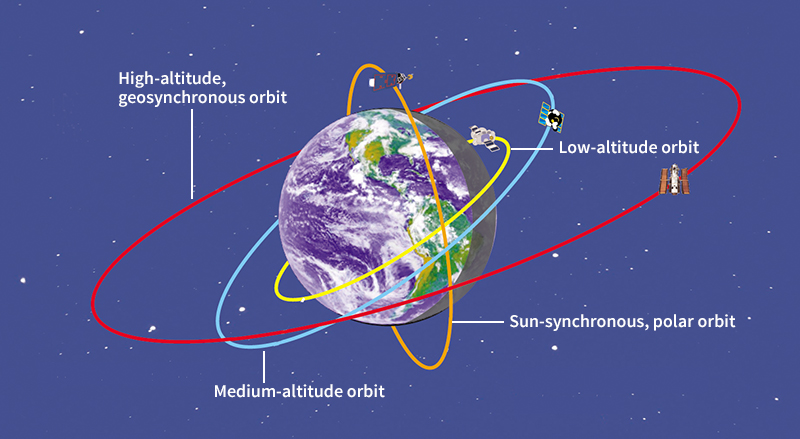
Many types of orbits exist, but most artificial satellites orbiting Earth travel in one of four types: (1) high altitude, geosynchronous; (2) medium altitude; (3) sun-synchronous, polar; and (4) low altitude. Most orbits of these four types are circular.
A high altitude, geosynchronous orbit
lies above the equator at an altitude of about 22,300 miles (35,900 kilometers). A satellite in this orbit travels around Earth’s axis in exactly the same time, and in the same direction, as Earth rotates about its axis. Thus, as seen from Earth, the satellite always appears at the same place in the sky overhead. To boost a satellite into this orbit requires a large, powerful launch vehicle.
A medium altitude orbit
has an altitude of about 12,400 miles (20,000 kilometers) and an orbital period of 12 hours. The orbit is outside Earth’s atmosphere and is thus very stable. Radio signals sent from a satellite at medium altitude can be received over a large area of Earth’s surface. The stability and wide coverage of the orbit make it ideal for navigation satellites.
A sun-synchronous, polar orbit
has a fairly low altitude and passes almost directly over the North and South poles. A slow drift of the orbit’s position is coordinated with Earth’s movement around the sun in such a way that the satellite always crosses the equator at the same local time on Earth. Because the satellite flies over all latitudes, its instruments can gather information on almost the entire surface of Earth. One example of this type of orbit is that of the TERRA Earth Observing System’s NOAA-H satellite. This satellite studies how natural cycles and human activities affect Earth’s climate. The altitude of its orbit is 438 miles (705 kilometers), and the orbital period is 99 minutes. When the satellite crosses the equator, the local time is always either 10:30 a.m. or 10:30 p.m.
A low altitude orbit
is just above Earth’s atmosphere, where there is almost no air to cause drag on the spacecraft and reduce its speed. Less energy is required to launch a satellite into this type of orbit than into any other orbit. Satellites that point toward deep space and provide scientific information generally operate in this type of orbit. The Hubble Space Telescope, for example, operates at an altitude of about 380 miles (610 kilometers), with an orbital period of 97 minutes.
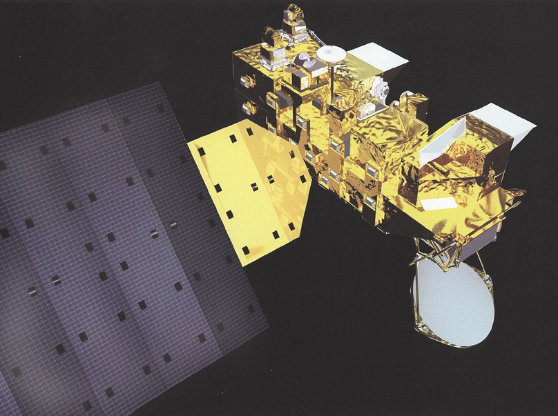
Types of artificial satellites
Artificial satellites are classified according to their mission. There are six main types of artificial satellites: (1) scientific research, (2) weather, (3) communications, (4) navigation, (5) Earth observing, and (6) military.
Scientific research satellites
gather data for scientific analysis. These satellites are usually designed to perform one of three kinds of missions. (1) Some gather information about the composition and effects of the space near Earth. They may be placed in any of various orbits, depending on the type of measurements they are to make. (2) Other satellites record changes in Earth and its atmosphere. Many of them travel in sun-synchronous, polar orbits. (3) Still others observe planets, stars, and other distant objects. Most of these satellites operate in low altitude orbits. Scientific research satellites also orbit other planets, the moon, and the sun.
Weather satellites
help scientists study weather patterns and forecast the weather. Weather satellites observe the atmospheric conditions over large areas.
Some weather satellites travel in a sun-synchronous, polar orbit, from which they make close, detailed observations of weather over the entire Earth. Their instruments measure cloud cover, temperature, air pressure, precipitation, and the chemical composition of the atmosphere. Because these satellites always observe Earth at the same local time of day, scientists can easily compare weather data collected under constant sunlight conditions. The network of weather satellites in these orbits also function as a search and rescue system. They are equipped to detect distress signals from all commercial, and many private, planes and ships.
Other weather satellites are placed in high altitude, geosynchronous orbits. From these orbits, they can always observe weather activity over nearly half the surface of Earth at the same time. These satellites photograph changing cloud formations. They also produce infrared images, which show the amount of heat coming from Earth and the clouds.
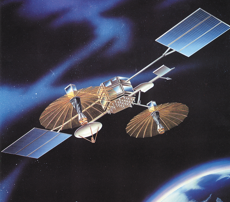
Communications satellites
serve as relay stations, receiving radio signals from one location and transmitting them to another. A communications satellite can relay television signals, phone calls, or internet data. Communications satellites are commonly put in a high altitude, geosynchronous orbit over a ground station. A ground station has a large dish antenna for transmitting and receiving radio signals. In other cases, a group of low orbit communications satellites arranged in a network, called a constellation, work together by relaying information to each other and to users on the ground. Countries and commercial organizations, such as television and radio broadcasters and telephone companies, use these satellites continuously.
Navigation satellites
enable operators of aircraft, ships, and land vehicles anywhere on Earth to determine their locations with great accuracy. Hikers and other people on foot can also use the satellites for this purpose. The satellites send out radio signals that are picked up by a computerized receiver carried on a vehicle or held in the hand.
Navigation satellites operate in networks, and signals from a network can reach receivers anywhere on Earth. The receiver calculates its distance from at least three satellites whose signals it has received. It uses this information to determine its location.
Earth observing satellites
are used to map and monitor our planet’s resources and ever-changing chemical life cycles. They follow sun-synchronous, polar orbits. Under constant, consistent illumination from the sun, they take pictures in different colors of visible light and non-visible radiation. Computers on Earth combine and analyze the pictures. Scientists use Earth observing satellites to locate mineral deposits, to determine the location and size of freshwater supplies, to identify sources of pollution and study its effects, and to detect the spread of disease in crops and forests.
Military satellites
include weather, communications, navigation, and Earth observing satellites used for military purposes. Some military satellites—often called “spy satellites”—can detect the launch of missiles, the course of ships at sea, and the movement of military equipment on the ground.
The life and death of a satellite
Building a satellite.
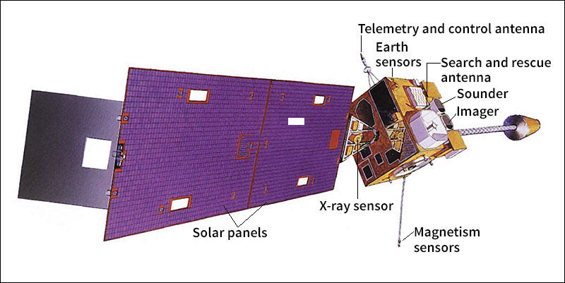
Every satellite carries special instruments that enable it to perform its mission. For example, a satellite that studies the universe has a telescope. A satellite that helps forecast the weather carries cameras to track the movement of clouds.
In addition to such mission-specific instruments, all satellites have basic subsystems, groups of devices that help the instruments work together and keep the satellite operating. For example, a power subsystem generates, stores, and distributes a satellite’s electric power. This subsystem may include panels of solar cells that gather energy from the sun. Command and data handling subsystems consist of computers that gather and process data from the instruments and execute commands from Earth.
A satellite’s instruments and subsystems are designed, built, and tested individually. Workers install them on the satellite one at a time until the satellite is complete. Then the satellite is tested under conditions like those that the satellite will encounter during launch and while in space. If the satellite passes all tests, it is ready to be launched.
Launching the satellite.
A satellite is launched either by an expendable launch vehicle, which is unusable after one launch, or by a reusable launch vehicle, which can launch multiple times. Many satellites require minor adjustments of their orbit before they begin to function. Built-in rockets called thrusters make these adjustments. Once a satellite is in a stable orbit, it can remain there for a long time without further adjustment.
Performing the mission.
Most satellites are directed from a control center on Earth. Computers and human operators at the control center monitor the satellite’s position, send instructions to its computers, and retrieve information that the satellite has gathered. The control center communicates with the satellite by radio. Ground stations within the satellite’s range send and receive the radio signals.
A satellite does not usually receive constant direction from its control center. It is like an orbiting robot. It controls its solar panels to keep them pointed toward the sun and keeps its antennas ready to receive commands. Its instruments automatically collect information.
Satellites in a high altitude, geosynchronous orbit are always in contact with Earth. Ground stations can contact satellites in low orbits as often as 12 times a day to transmit information and instructions. Each contact must be completed during the time the satellite passes overhead—about 10 minutes.
If some part of a satellite breaks down, but the satellite remains capable of doing useful work, the satellite owner usually will continue to operate it. In some cases, ground controllers can repair or reprogram the satellite. Some satellites can be sent to perform a completely new task once the initial mission has concluded. In rare instances, space shuttle crews retrieved and repaired satellites in space. If the satellite can no longer perform usefully and cannot be repaired or reprogrammed, operators from the control center send a signal to shut it off.
Falling from orbit.
A satellite remains in orbit until its velocity decreases and gravitational force pulls it down into a relatively dense part of the atmosphere. A satellite slows down due to occasional impact with air molecules in the upper atmosphere and the gentle pressure of the sun’s energy. When the gravitational force pulls the satellite down far enough into the atmosphere, the satellite rapidly compresses the air in front of it. This air becomes so hot that most or all of the satellite burns up.
History
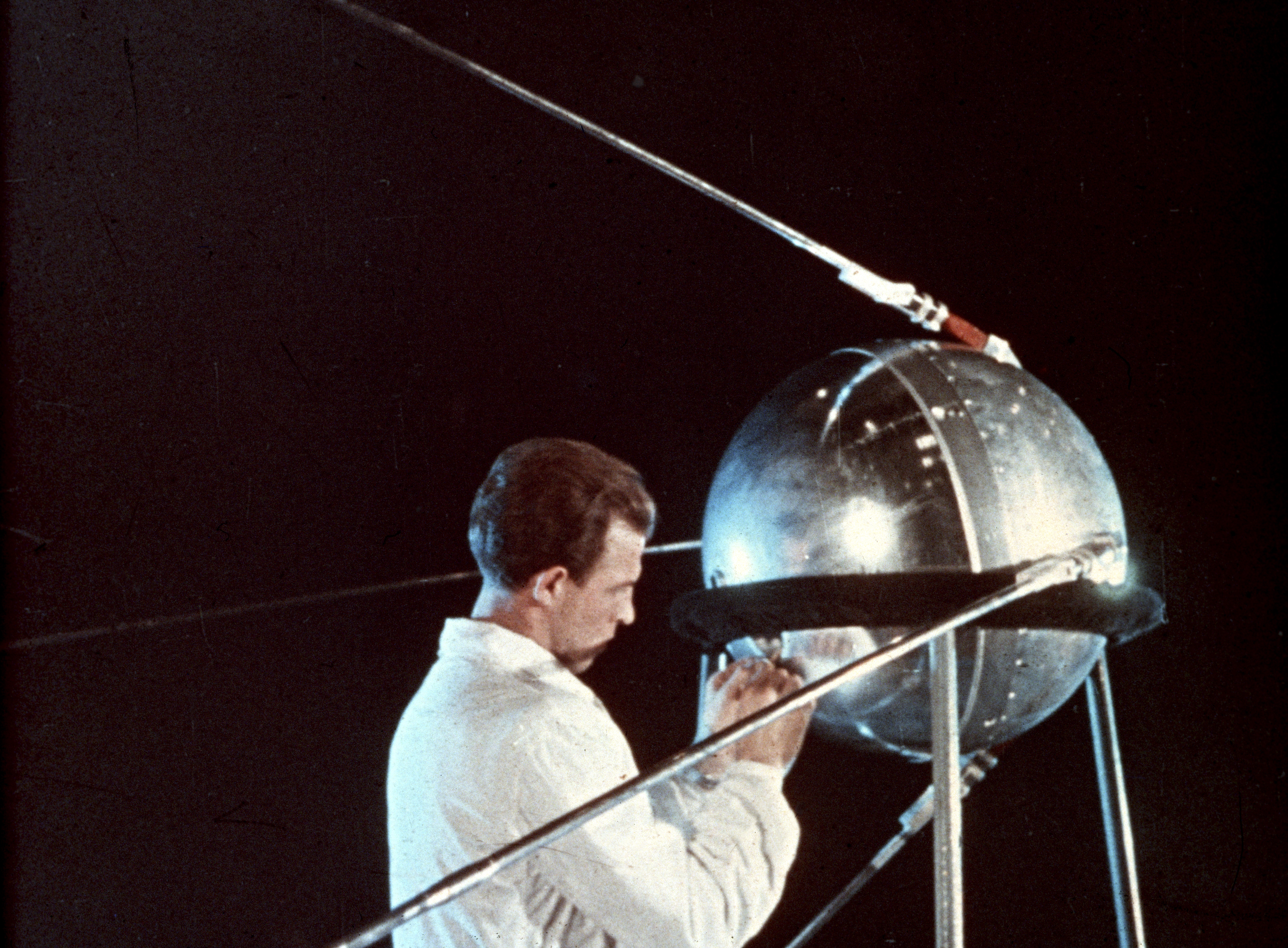
In 1955, the United States and the Soviet Union announced plans to launch artificial satellites. On Oct. 4, 1957, the Soviet Union launched Sputnik 1, the first artificial satellite. It circled Earth once every 96 minutes and transmitted radio signals that could be received on Earth. On Nov. 3, 1957, the Soviets launched a second satellite, Sputnik 2. It carried a dog named Laika, the first animal to soar in space. The United States launched its first satellite, Explorer 1, on Jan. 31, 1958, and its second, Vanguard 1, on March 17, 1958.
In August 1960, the United States launched the first communications satellite, Echo I. This satellite reflected radio signals back to Earth. In April 1960, the first weather satellite, TIROS I, sent pictures of clouds to Earth. The U.S. Navy developed the first navigation satellites. The Transit 1B navigation satellite first orbited in April 1960. By 1965, more than 100 satellites were being placed in orbit each year.
Since the 1970’s, scientists have created new and more effective satellite instruments and have made use of computers and miniature electronic technology in satellite design and construction. In addition, more nations and some private businesses have begun to purchase and operate satellites. By the early 2000’s, dozens of countries owned satellites, and hundreds of satellites were operating in orbit.
During the 2000’s, small satellites such as cubesats grew in popularity. A cubesat is a cube-shaped satellite that measures 10 centimeters (4 inches) on each side. Cubesats are often used in scientific research. Small satellites are inexpensive to build and launch because they require few resources. A single rocket can launch many small satellites at once. In the late 2010’s, reusable launch vehicles became commercially available. These rockets can be launched multiple times, reducing the cost of an individual launch.
In the early 2020’s, satellite launches became so inexpensive that many more satellites entered orbit than ever before. In 2020, there were about 3,200 active satellites in orbit. In 2022, they numbered more than 6,900. So many new satellites were launched that scientists became concerned about their effects on Earth. Launching satellites contributes to pollution, and satellites in orbit interfere with astronomical observations.
Crowded space can also increase the risk of collisions between satellites, or between satellites and micrometeoroids (particles of space dust). Such collisions can damage or destroy satellites. Destructive collisions also add to space debris (junk in orbit), further increasing the risk of future collisions. Many scientists want government agencies to regulate large satellite networks more strictly, in order to minimize collision risk.
