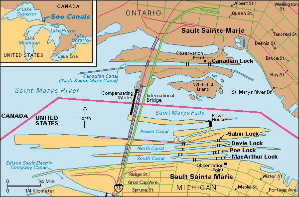
Soo Canals permit ships to pass between Lakes Superior and Huron. They are on the United States-Canadian border. About 85 to 90 per cent of the tonnage on the canals is eastbound. Iron ore, grain, and coal make up most of the eastbound cargo. Coal, stone, and oil are the chief products carried on westbound ships. About 85 million short tons (77 million metric tons) of cargo pass through these canals annually. Ice closes the Soo Canals from about mid-December to early April.

The Saint Marys River forms a natural connection between Lakes Superior and Huron. Early trappers sometimes “ran the rapids” to cross from one lake to the other. However, they usually carried their canoes and furs around the rough water. In 1798, the Hudson’s Bay Company completed a canal with a single lock that permitted canoes and flat-bottomed boats to pass up the river. American troops destroyed the lock during the War of 1812. After 1839, ships were moved around the rapids on rollers. A railroad was built in 1850.
The American canals.
Increasing shipments of iron and copper during the late 1800’s created a need for better transportation between lakes Superior and Huron. A federal grant enabled Michigan to complete a canal with a lock in 1855. The U.S. government took over the canal’s administration in 1881, and abolished tolls.
The American canals, also called the St. Marys Falls Canal and Locks, are about 13/4 miles (2.8 kilometers) long. Davis lock, opened in 1914, and Sabin lock, opened in 1919, are in the North Canal. The South Canal includes MacArthur lock, opened in 1943, and the new Poe lock, opened in 1968. This new lock, 110 feet (34 meters) wide, is the widest of the American canals. It handles vessels up to 105 feet (30 meters) wide and 1,000 feet (300 meters) long. The new lock replaced a smaller Poe lock, which was torn down in 1962.
The Canadian canal.
Canada completed its canal in 1895. Until the Davis lock was built, the larger lake ships used the Canadian canal. The Canadian canal, also called the Sault Sainte Marie Canal, is 13/10 miles (2 kilometers) long and 150 feet (46 meters) wide.
The 2-mile (3-kilometer) International Bridge carries traffic across the Saint Marys River at Sault Ste. Marie. The bridge opened in 1962.
