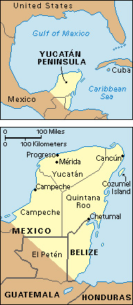
Yucatán, << `yoo` kuh TAN or `yoo` kuh TAHN, >> Peninsula includes the southeastern Mexican states of Campeche, Quintana Roo, and Yucatán; Belize; and part of El Peten, a department of Guatemala. The peninsula separates the Gulf of Mexico from the Caribbean Sea. It covers over 75,000 square miles (194,000 square kilometers).

The peninsula is a low, rolling tableland of coral and limestone covered by a thin layer of soil. It has a hot, humid climate. Tropical rain forests cover the lowlands. Quintana Roo and Belize lie along the eastern coast of the peninsula. The state of Yucatán is in the peninsula’s northern part. The state of Campeche lies south and west of Yucatán. Part of El Peten in Guatemala is inland in the peninsula’s southern part. The chief cities include Merida, capital of Yucatán; Campeche, capital of Campeche; and Progreso, Yucatán, the peninsula’s chief port. Cancun, in Quintano Roo, is a popular resort area.
Most of the people, called Yucatecos, are descendants of the Maya Indians who lived in Yucatán hundreds of years before the Spaniards arrived. Ancient ruins of the Maya civilization have been found in Yucatán (see Maya ). Most Yucatecos are farmers. Northern Yucatán is one of the chief henequen-raising areas of the world. Henequen is used in making twine. Other crops of the Yucatán Peninsula include cacao, coffee, corn, cotton, sugar cane, and tobacco.
Francisco Fernández de Córdoba, a Spaniard, came to the peninsula in 1517. By 1542, Francisco de Montejo the Younger had set up Spanish rule over half of Yucatán and established the cities of Campeche and Merida. Some of the Indians became slave laborers on henequen plantations. During the 1800’s and 1900’s, the Indians revolted several times against the Mexican government. Salvador Alvarado and Felipe Carillo, who served as governors of Yucatán in the early 1900’s, introduced many reforms.
