Yukon << YOO kon >> is a territory in northwest Canada. It is part of a vast subarctic region with long, cold winters and short, warm summers. Yukon is sparsely populated due to its isolation and the seasonal nature of its economy. Yukon has rich mineral deposits and magnificent scenery. Many prospectors hurried to the region during the Klondike Gold Rush of 1897 to 1900. Today, mining remains an important industry. Tourism and government services are also important to the economy.
Yukon is one of three political units in Canada known as territories. The other two are the Northwest Territories and Nunavut. Whitehorse is Yukon’s capital and largest city.
The people
Most Yukoners have some British ancestry. Yukon is also home to more than 6,900 First Nations people. First Nations are Indigenous (native or original) peoples of the land that is now Canada. Almost all the people speak English. French is the native language of about 1,800 Yukoners. Indigenous languages are spoken in some villages, but their usage is declining.
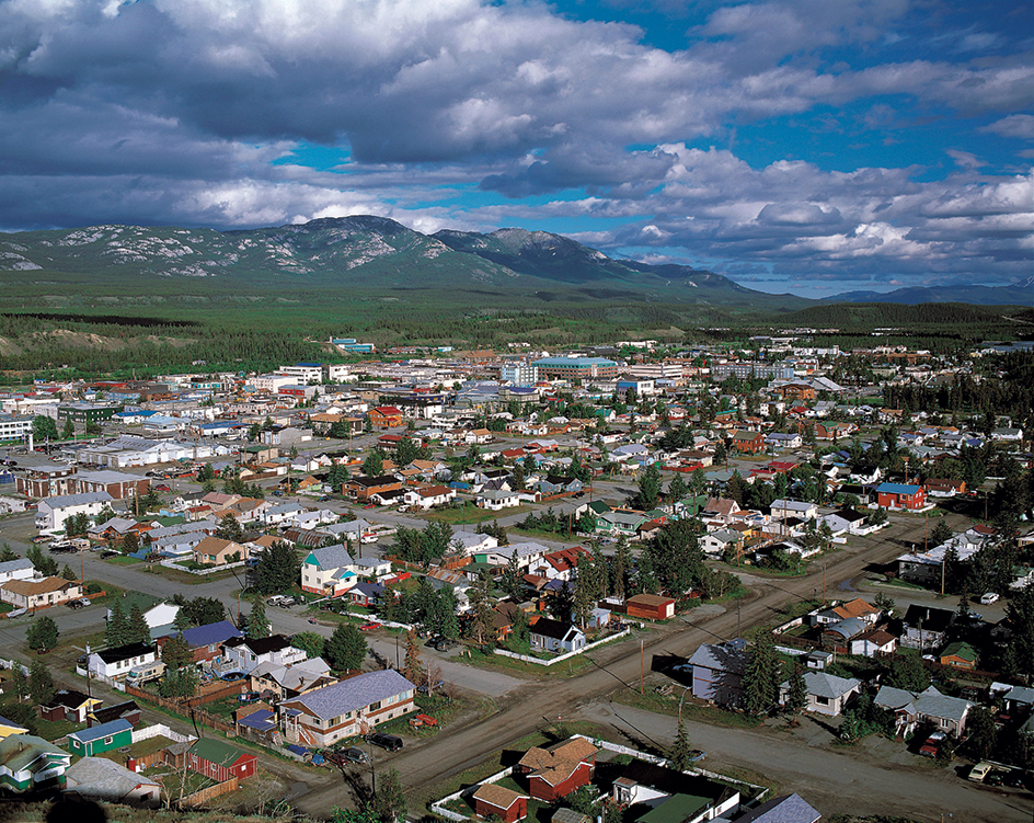
About two-thirds of the territory’s people live in Whitehorse. Other Yukon communities include Dawson, Faro, Haines Junction, Ross River, and Watson Lake.
Most people live in modern houses. Electric heaters, oil, and wood provide heat. The burning of wood has caused air pollution in the Whitehorse area. Daily airline and trucking services bring perishable foods and other goods to the territory.
The land and its resources
Location, size, and description.
Yukon covers 186,661 square miles (483,450 square kilometers) in the shape of a rough triangle. The base borders British Columbia, and the peak borders the Arctic Ocean. Alaska lies west of Yukon. The Northwest Territories lies to the east.
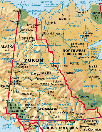
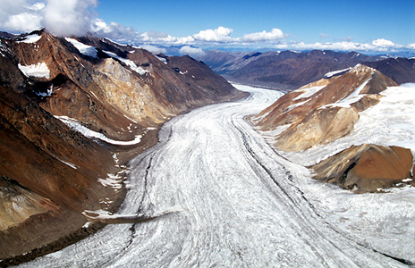
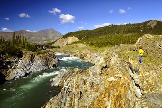
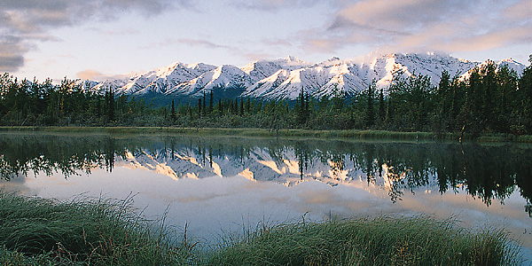
A series of mountain ranges covers much of Yukon. The Rockies form part of this system but spread out into smaller chains in the southeast, near the Liard River. The highest peaks rise in the Saint Elias Mountains in the southwest. Mount Logan (19,551 feet, or 5,959 meters), in this range, is the highest point in Canada (see Mount Logan). A valley called the Tintina Trench divides the major mountain ranges from northwest to southeast.
The territory gets its name from the Yukon River. The word Yukon probably came from the Gwich’in Indigenous word Youcon, meaning greatest or big river. The Yukon River drains more than half of the territory. Most of the rest is drained into the Mackenzie River through the Peel and Liard river systems.
Natural resources.
The territory has large deposits of coal, copper, gold, lead, nickel, silver, and zinc. Extensive forests of white spruce cover much of the land. Other trees include birch, fir, pine, and poplar.
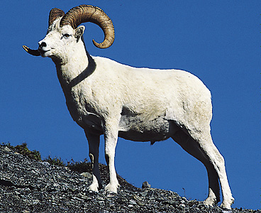
Many fur-bearing animals live in Yukon. Animals of the region include bears, caribou, Dall’s sheep, elk, moose, mountain goats, and wolves. There are a small number of bison. Yukon’s game birds include grouse, ptarmigan, and waterfowl. Rare gyrfalcons and peregrine falcons also live in the territory. Grayling, northern pike, lake and rainbow trout, salmon, and whitefish swim in Yukon’s streams and lakes.
Climate.
Yukon has cold winters and warm summers. The climate is semiarid. Average January temperatures are 5 °F (–15 °C) at Whitehorse and –15 °F (–26 °C) at Dawson. Summer temperatures average from 50 °F (10 °C) in the north to 61 °F (16 °C) in the south. Annual snowfall varies from 40 inches (102 centimeters) in the north to more than 79 inches (200 centimeters) in the south. Rainfall averages from 6 to 10 inches (15 to 25 centimeters) per year.
Economy
Service industries
contribute more to Yukon’s economy than any other economic activity. Important community, business, and personal services in the territory include education and health care. Government services employ about a third of the work force.
Tourism contributes heavily to Yukon’s economy. Every year, hundreds of thousands of people travel across Yukon on the Alaska Highway. Many people consider the Yukon section of the highway to be the most scenic section. Tourists also visit scenes of the Klondike Gold Rush. The Dawson Historical Complex National Historic Site has preserved many landmarks of that era. Attractions in Whitehorse include the MacBride Museum, the Yukon Beringia Interpretive Centre, and the S.S. Klondike, an old Yukon paddlewheeler (kind of boat). Yukon also has three national parks—Kluane, Ivvavik, and Vuntut.
Mining.
Yukon’s mining industry is based mostly on the production of metal ores. The value of Yukon mineral production often varies greatly from year to year. This happens because the price of metal ores is unstable.
Copper and gold are Yukon’s leading mined products. Other mined products include silver and sand and gravel. Yukon also produces a dwindling amount of natural gas.
Agriculture.
Because of the short summer, most farmers plant only quick-growing vegetables. Some farmers have market gardens, and others grow hay. Excellent vegetables are grown in greenhouses during the long daylight hours of spring and summer. Some farmers raise livestock. The territory also has a small number of commercial egg producers.
Manufacturing.
Yukon has several small manufacturing industries. Goods manufactured there have a value added by manufacture of about 20 million Canadian dollars a year. This figure represents the difference between the value of raw materials and the value of finished products. Yukon’s products include printed materials, fabricated metal products, and processed foods, especially fish. Other industries include breweries and wood product manufacturers.
Fishing industry.
A small amount of commercial salmon fishing takes place in the territory. It occurs mainly on the Yukon River system.
Fur industry.
Some of Yukon’s people make a living as trappers. The chief animals trapped include beavers, lynxes, martens, wolverines, and wolves.
Electric power.
About 90 percent of Yukon’s electric power comes from hydroelectric sources. Most of the rest comes from generators burning fossil fuels. Wind power generates a small amount of electric power.
Transportation and communication.
Airlines connect Yukon with various destinations in Canada and Alaska. The Alaska Highway extends for about 600 miles (970 kilometers) through the territory. The 450-mile (725-kilometer) Dempster Highway links Yukon with Inuvik in the Northwest Territories. Bus service provides connections to cities in Alaska, Alberta, and British Columbia.
The government-run Canadian Broadcasting Corporation/Radio-Canada (CBC/Radio-Canada) has a radio station at Whitehorse. Automatic relays transmit its programs to the entire territory. Several other radio stations also serve Yukon. Live CBC television service reaches nearly all Yukon communities via satellite (see Canadian Broadcasting Corporation/Radio-Canada (CBC/Radio-Canada)). Most areas also have access to telephone, wireless and high-speed internet, and cable television services. Leading newspapers include the Yukon News, published in Whitehorse, and the Klondike Sun, published in Dawson.
Education and social services
Education.
The territorial government is responsible for the school system. Francophone (French-speaking) and First Nations school boards oversee a number of public schools. Whitehorse schools offer a full range of public and private education programs. Most of the larger rural communities have schools that provide kindergarten through grade 8 education. Some also include grades 9 through 12. Students from communities that do not offer grades 9 through 12 may attend school in Whitehorse or another community. Yukon University offers Adult Basic Education, vocational education, and some bachelor’s and master’s degree programs.
Social services.
Resident doctors live in Dawson, Mayo, Watson Lake, and Whitehorse. Resident dentists have offices in Dawson and Whitehorse. Visiting dentists treat residents of other communities. Watson Lake and Whitehorse have hospitals. Health centers with nurse practitioners (nurses with additional training in a specialized area) serve other settlements. Patients with certain needs are airlifted to Vancouver, British Columbia.
Government
The Canadian government appoints a commissioner to serve as honorary head of Yukon’s government. The commissioner acts on recommendations from an Executive Council (cabinet), whose members direct government departments. A premier presides over the council and is the actual head of the territorial government. The premier belongs to the elected Yukon Legislative Assembly. The premier is the head of the party with the most seats in the Assembly. The Assembly is the territory’s lawmaking body. The territorial government deals with such regional matters as education, natural resources, public works, social services, and taxation. The people elect one representative to the Canadian House of Commons. One member in the Canadian Senate also represents Yukon.
History
First Nations have lived in the Yukon area since prehistoric times. In the 1840’s, Robert Campbell became the first white person to explore the upper Yukon River region. Campbell was a British fur trader of the Hudson’s Bay Company. He built a trading post at Fort Selkirk, at the junction of the Pelly and Yukon rivers, in 1848. But Chilkat First Nations people soon destroyed the post. The Yukon area was part of the Hudson’s Bay Company’s fur-trading empire until the 1890’s. Competition from the United States then forced the company to shift its operations east. In 1895, the Yukon region was made a district of the North-West Territories.
On Aug. 17, 1896, George W. Carmack and his First Nations friends Skookum Jim and Dawson Charlie made a gold strike on Bonanza Creek. This led to the Klondike Gold Rush from 1897 to 1900. The creek is a tributary of the Klondike River, near present-day Dawson. Tens of thousands of prospectors poured into the Yukon region when news of the discovery spread. These miners were often rough and unruly. A detachment of the North-West Mounted Police had entered the region before the gold rush, and they maintained order throughout the rush. See Klondike.
At the height of the Klondike Gold Rush in 1898, an estimated 40,000 people lived in the Yukon region. Records show that 7,080 boats passed down the Yukon River in 1898, carrying 28,000 people. Approximately 5,000 people came to the region by other routes.
The influx of people caused by the gold rush temporarily increased the Yukon region’s political importance. In 1898, the region became a territory of Canada. Dawson City was its capital. Simple methods of hand mining produced $22,275,000 of gold in 1900. A fleet of gold dredges soon began digging up gold. Mining companies continue to extract gold from the Klondike gold field, even though the area has been mined several times.
After much of the surface ore had been exhausted, many prospectors left the Klondike area. Railroad service connected Whitehorse to Skagway, on Alaska’s coast. As a result, Whitehorse became Yukon’s shipping center.
Yukon experienced a second boom during World War II (1939-1945), when construction of the Alaska Highway, Northwest Staging Route, and Canol Pipeline brought thousands of workers and military personnel to the territory. Whitehorse replaced Dawson, which was not on the Alaska Highway, as the territory’s capital in 1953.
In 1979, the federal government transferred authority over some local matters from the commissioner to the elected council. These matters included education and taxation. The economy declined in the early 1980’s, mostly due to low metal prices. By the end of the 1980’s, the economy had improved because of higher metal prices, greater government spending, and the expansion of the tourist industry.
For many years, Yukon’s First Nations have sought self-government and title to their traditional lands. In 1995, government authorities and the Council for Yukon First Nations reached a land claims agreement. The agreement provided land, financial compensation, and self-government to those First Nations that signed it.
