Arnhem Land is a region in the northeastern corner of Australia’s Northern Territory. The region has a tropical climate. Tidal creeks flow through mangrove swamps and thick jungles on the coastal plain that extends about 20 to 30 miles (30 to 50 kilometers) inland. A tableland that rises to about 1,640 feet (500 meters) above sea level in the center of the area is largely unexplored.
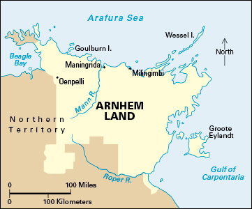
In 1931, the Australian government set aside about 30,000 square miles (80,000 square kilometers), including islands off the coast, as reserves for local Aboriginal people. Today, Arnhem Land is one of the last strongholds of traditional Aboriginal life. About 9,000 Aboriginal people live in the area. Some of them have chosen to live a more traditional life in smaller centers. But most live in settlements originally established by government and mission bodies. The main settlements include Goulburn, Groote Eylandt, Maningrida, Milingimbi, and Oenpelli.
Willem van Colster, a Dutch explorer, sighted the eastern coast of Arnhem Land in 1623. He named the region after his ship, the Arnhem. In 1644, the Dutch explorer Abel Janszoon Tasman charted the coastline of the Arnhem Land region.
See also Yunupingu, Galarrwuy.
