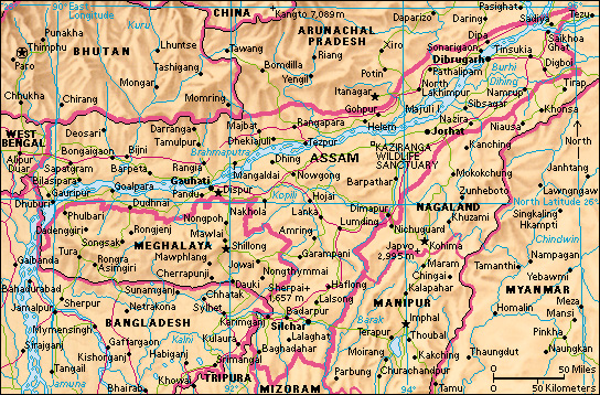
Assam (pop. 31,205,576) is a state in northeastern India, in the low-lying Brahmaputra Valley. Assam has international borders to the north with Bhutan and to the southwest with Bangladesh. Also to its north and east lies Arunachal Pradesh. Assam shares a border with four hill states—Nagaland and Manipur to the east, and Mizoram and Tripura to the south. It has a further short stretch of border with Bangladesh between Tripura and Meghalaya, which borders Assam to its southwest. Dispur is the capital of Assam.

Assam is the largest and most highly populated state in the region. Assam is famous for its tea. The game reserves at Kaziranga and Manas are also well known.
People and government
The population of Assam is of varied origin. Many people are descendants of eastern Asians. The main language is Assamese. Bengali is also spoken. About 60 percent of the people are Hindus, and 35 percent are Muslims. Buddhism is the other major religion. About 85 percent of the people live in rural areas.
Assam has 14 elected members in the Lok Sabha (lower house) and 7 nominated representatives in the Rajya Sabah (upper house) of the Indian national parliament. The state legislative assembly has 126 members.
Economy
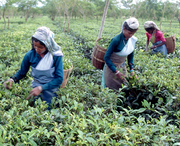
Hundreds of tea plantations in Assam produce more than half of India’s tea, and about 15 percent of world tea production. Farmers also grow bananas, oranges, peas, pineapples, potatoes, sugar cane, and a variety of grains.
Prospectors found oil reserves in Assam in the 1800’s. Digboi became the site of Asia’s first oil refinery in 1899. The Gauhati Refinery was erected in 1961. It produces diesel, kerosene, liquefied petroleum gas, and petrol. There is also an oil refinery near Bongaigon. Low quality coal is mined, mainly for use on the railways. Forests cover about a fifth of the state. They provide essential resources, not only of timber but also resin and tanning material from tree bark. Bamboo has many uses, especially for paper making. Traditional handicraft industries, such as weaving and pottery, are also important.

Other industries in the state produce cement, fertilizers, and paper. Coal, dolomite, limestone, and refractories are mined in the state (see Refractory).
For many years, river transport was the main form of transportation in Assam. The state’s main airport is in Gauhati. Smaller airports operate at Dibrugarh, Jorhat, Tezpur, and Silchar. A network of railroads and highways connect the state with many of India’s cities.
Land and climate
Assam occupies the long narrow floor of the Brahmaputra Valley. It is overshadowed by the Himalaya to the north and the Shillong Plateau to the south. The valley floor, even in the shelter of the Shillong Plateau, still receives heavy rainfall during the monsoon season of May to October (see Monsoon). Rainfall averages about 90 inches (230 centimeters) during the summer monsoon. On average, less than 1.6 inches (4 centimeters) fall from November to February. Temperatures along the valley rarely drop below 54 °F (12 °C), the average minimum temperature for January. Average minimum temperatures rise to 79 °F (26 °C) in July and August. Average maximum temperatures are 73 °F (23 °C) in January, rising to 86 °F (30 °C) in April and again from June to August.
Most of Assam is low-lying. On the banks of the Brahmaputra, the Kaziranga National Park occupies about 166 square miles (430 square kilometers). It combines grassland with thorny rattan cane, elephant grass, and evergreen forest as well as areas of swampy ground and extensive ponds and lakes. Kaziranga became a forest reserve (1908) and later a game sanctuary (1926), in order to save the Indian one-horned rhino, which had been in danger of extinction around 1900. The rhino population has grown significantly, though poachers still kill the animals for their horns. The park also has bison, elephants, hog deer, hoolock gibbons, leopards, swamp deer, tigers, wild boar, and wild buffalo. There are otters in the rivers as well as the gavial (long-snouted, fish-eating crocodile).
The Brahmaputra River dominates Assam. After flowing eastward to the north of the Himalaya, it turns sharply south and then passes through the Assam Valley from east to west before entering Bangladesh.
History
The ancient kingdom of Kamarupa once covered the present state of Assam. Pragjyaisha, the capital, was located near Gauhati. Kamarupa is mentioned as a frontier kingdom and tributary of the Gupta Empire in the Allahabad inscription of Samudra Gupta (A.D. 330-375). Until the 1200’s, the area was ruled by a succession of dynasties, including the Salastamba, the Brahmapala, and the Bhuyan.
The Ahoms, a Thai-Buddhist people from the southeast, arrived in the area in the early 1200’s. They deposed the ruler and established a kingdom with its capital in Sibsagar. By 1353, the Ahoms controlled a major part of the area, which they renamed Assam. The Ahoms adopted the language and Hindu religion of the conquered people and ruled Assam for about 500 years.
A part of the Ahom territory bordered the Mughal Empire. The attempts of the Mughals to extend their territory into Assam resulted in conflict for several hundred years. Although the Ahoms temporarily lost control in 1663, they inflicted a crushing defeat on the Mughals in 1671.
Internal dissension led to the fall of the Ahom kingdom. In 1771, the British East India Company gave military assistance to the Ahom ruler to quell a revolt. In return, the Company received commercial privileges.
In 1817, the Burmese took advantage of the rivalry between the Ahom chiefs, invaded Assam, and established political control. The Burmese presence threatened British commercial interests. In the first Burmese War (1824-1826), the British drove the Burmese out of Assam. Under the Treaty of Yandabo, the territory was annexed by the East India Company on 24 Feb., 1826. During the 1800’s, many Muslim settlers moved to Assam from Bengal. The government of the United Kingdom administered the state from 1858 until 1947.
India achieved independence in 1947 and Assam became a state of the Indian Union. The Congress Party dominated politics. In five of the seven elections held before 1980, the Congress Party won more than 50 percent of the vote and at least 9 of the 14 seats allocated to the state in the Lok Sabha. In 1985, a new regional party, the Asom Gana Parishad (AGP), emerged and defeated the Congress Party in state assembly elections. In state elections in 1991, the Congress Party was returned to power. In 1996 elections, the AGP regained power in the state.
The emergence of separatist trends has unsettled normal life in Assam. The United Liberation Forces of Assam (ULFA), an extremist organization, stands for the independence of Assam. The Bodo movement advocates autonomy for the region inhabited by the Bodos.
