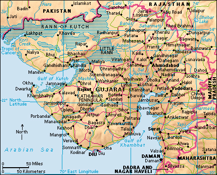
Dadra and Nagar Haveli and Daman and Diu (pop. 586,956) is one of the union territories of India. It consists of four small, geographically separated areas, each located on or near the west coast of India. The city of Daman is the capital of the union territory. The largest city is Silvassa in Nagar Haveli.

The union territory of Dadra and Nagar Haveli and Daman and Diu covers about 233 square miles (603 square kilometers). Its government is headed by an administrator appointed by the president of India.
Dadra and Nagar Haveli together form one of the territory’s three districts and cover about 190 square miles (491 square kilometers). Nagar Haveli lies in the foothills of the Western Ghats between the Indian states of Gujarat and Maharashtra. Dadra is a small area a few miles north of Nagar Haveli and is entirely surrounded by Gujarat. The Daman Ganga River flows northwest through both Nagar Haveli and Daman and reaches the coast at Daman.
The district of Daman, which includes the union territory’s capital city, covers about 28 square miles (74 square kilometers). It lies along the Gulf of Khambhat where the gulf opens into the Arabian Sea. The district of Diu is on the other side of this opening, about 120 miles (195 kilometers) west of Daman. It consists primarily of Diu, an island of plains and low hills with an area of about 15 square miles (38 square kilometers). The district of Diu also includes a small amount of land on the nearby Kathiawar Peninsula. Bridges connect the island with the peninsula.
The climate is warm in all the districts. Summers are hot, and winters are warm. Monsoon winds bring heavy seasonal rainfall during the summer and early autumn.
Most of the people of the union territory are Adivasis, a name that means original inhabitants. They belong to a number of tribal groups, including the Dhodias, Dublas, Koknas, and Varlis.
The economy is based mainly on agriculture. Major farm products include rice, pulses, and fruits. Daman is a port. Its economy relies on agriculture, marine products, and trade. In Diu, fishing and salt making are important occupations.
The early history of what is now Dadra and Nagar Haveli and Daman and Diu is closely connected with the history of the surrounding territories of Gujarat and Maharashtra. A long succession of Indian empires ruled the region.
Portugal established its first colonial settlement in India at Goa on India’s west coast in 1510. In 1535, the shah of Gujarat agreed to allow the Portuguese to build a fort on the island of Diu in return for aid against an invasion by the Mughal emperor. The Mughal Empire ruled most of India during the 1500’s and 1600’s. By the end of 1559, the Portuguese had taken over both Diu and Daman, enabling them to control shipping in and out of the Gulf of Khambhat. The territories were responsible to the Portuguese governor general at Goa. The Portuguese acquired Dadra and Nagar Haveli in the 1780’s.
India gained independence from the United Kingdom in 1947, but Portugal refused to give up its Indian territories. In 1954, Indian nationalists seized control of Dadra and of Nagar Haveli and formed a pro-Indian administration. India officially made the areas a union territory in 1961. In December 1961, India seized control of Daman, Diu, and Goa. It made them a union territory in 1962. In 1987, India made Goa a state, while Daman and Diu remained a union territory. India’s states have greater independence from the federal government’s authority than do the union territories. On Jan. 26, 2020, India combined the union territory of Dadra and Nagar Haveli and the union territory of Daman and Diu to create a single union territory called Dadra and Nagar Haveli and Daman and Diu.
