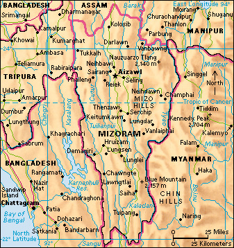
Mizoram (pop. 1,097,206) is a state in the far northeast of India. It is the southernmost of the hill states, and lies between Myanmar (formerly Burma) in the east and Bangladesh in the west. It covers an area of 8,139 square miles (21,081 square kilometers). Its capital is Aizawl.

The people.
Mizo is the collective name for the peoples who settled in the area in the 1700’s. The name comes from the words mi (man) and zo (mountain). The two main local languages are Mizo and English. Most Mizo are Christian converts. The remainder, mainly nomadic Chakmas along the western border, are Buddhists who have a tradition taking in elements of Hinduism and local folk religions.
Housing styles are well adapted to the steep terrain, with front doors at street level and the backs standing on stilts. Most homes display orchids, and pots of geranium, begonia, and balsam. Mizoram University opened in Aizawl in 2001.
Government.
Mizoram has one elected member in the Lok Sabha (lower house) and one nominated representative in the Rajya Sabha (upper house) of the Indian national parliament. The state legislative assembly has 40 seats.
Economy.
Most of the people of Mizoram work in agriculture. Many follow a nomadic “slash-and-burn” method of shifting cultivation called jhum, but the government has encouraged terraced farming. Plantation crops such as coffee, rubber, and tea are also grown.
Many people are employed making handwoven textiles and other handmade objects. There are no large-scale industries. The government has sponsored some light industrial development in Aizawl. Bamboo is a raw material for a range of goods, including ceremonial hats known as khumbou. Developing industries include fruit preservation, the production of ginger beverages, and sericulture—that is, the rearing of silkworms for the production of raw silk.
Aizawl has direct air connections with Kolkata (formerly called Calcutta). The state’s only main road runs north from Aizawl to Silchar in Assam. A railroad in the northern part of the state connects Mizoram and Assam.
Land and climate.
Mizoram has a long eastern border with Myanmar. It has state borders with Manipur, Assam, and Tripura to the north, and a western border with the Chittagong Hill Tracts of Bangladesh.
Mizoram has several ranges of hills running north to south near the border with Myanmar. The hills are covered with dense forests of bamboo and wild banana. At the bottom of the deep gorges, the rivers run in narrow ribbons. The rivers rise in the middle of the state. The north-flowing rivers join the Meghna system, which runs through Bangladesh. In the south, the rivers flow into Myanmar. Villages perch on top of the ridges. Aizawl is built on one of the sharpest ridges in India. Elephants, gibbons, hog deer, wild pigs, and tigers live in the forests.
Mizoram lies in the monsoon belt between South and Southeast Asia. The hills are high enough to give cooler summers than on the plains of Bangladesh or Myanmar. Even so, in summer, average maximum temperatures are 84 °F (29 °C) and average minimum temperatures are 68 °F (20 °C). In winter, maximum temperatures are 70 °F (21 °C) and minimum temperatures are 52 °F (11 °C). The state has a heavy annual rainfall of about 120 inches (300 centimeters). But there is also a dry season from late October to April.
History.
Mizoram has long been an area of nomadic populations. The different groups of ethnic peoples originally came from northwest China, and gradually moved southward toward Tibet and Burma in the A.D. 600’s. They reached Mizoram in the 1700’s.
The Mizos often raided British tea plantations in neighboring areas during the 1800’s. The disruption continued until 1891, when the territory was annexed to British India and organized into two districts—North Lushai Hills under Assam, and South Lushai Hills under Bengal. In 1898, it was formed into the Lushai Hills District and became part of Assam. Under colonial rule, Christian missionaries entered the area freely. They not only carried out their religious duties but also introduced literacy (the ability to read and write), which is exceptionally high in this state. The written language uses the Roman alphabet.
The Indian parliament renamed the territory the Mizo Hills District in 1954. The territory was called Mizoram when it became a union territory on Jan. 21, 1972. It became a state on Feb. 20, 1987.
