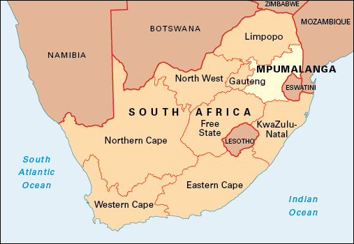
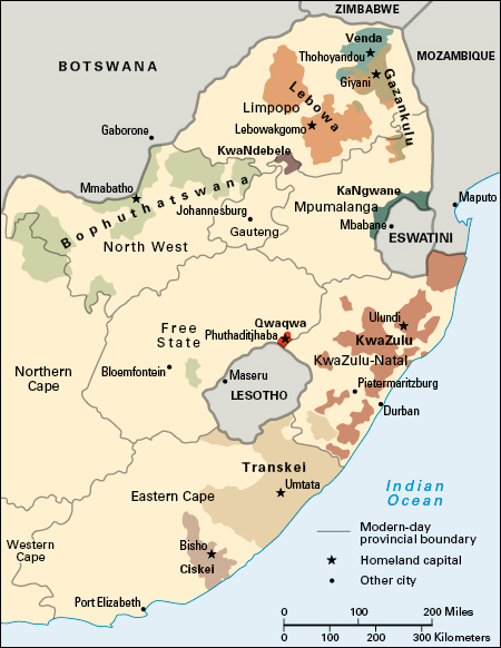
Mpumalanga is a province in the northeastern part of South Africa, bordering Mozambique and Eswatini. The province came into being in April 1994 as Eastern Transvaal. In 1995, the name was changed to Mpumalanga, which means where the sun rises. Before April 1994, the area that is now Mpumalanga was part of the province of Transvaal. Mpumalanga includes the former Black African homelands of KaNgwane and KwaNdebele. It covers an area of 29,534 square miles (76,495 square kilometers). The capital is Nelspruit.

The most commonly spoken language in the province is Swazi (siSwati), followed by Zulu (isiZulu), Xitsonga, Ndebele (isiNdebele), and Sepedi. Most of the people are of African descent. Others include people of European descent and people of mixed ancestry. Some refugees from Mozambique also live in the province. A majority of the province’s people live in rural villages and settlements. Some of the rural areas lack basic services, such as schools and hospitals. Many people live in poverty, especially in the overcrowded former homelands.
Economy.
Much of Mpumalanga is farmland. The subtropical climate of the lower-lying areas encourages the cultivation of avocado pears, bananas, citrus fruit, coffee, cotton, guavas, litchis, mangoes, papayas, tea, tobacco, and tomatoes. Corn is an important crop in the higher-lying areas. Forestry undertaken in the province supplies the local wood, pulp, and paper industries.
There are rich coal deposits in the western parts of the province, especially in the eMalahleni area. Mines in Mpumalanga also produce andalusite, chrysotile, gold, lead, manganese, silver, titanium, and vanadium.
Manufacturing in the province centers on chemical processing and the production of petroleum products and paper and pulp.
Tourism is an important part of the economy. It is based on the scenically beautiful eastern areas of the province, which include part of Kruger National Park, a large wildlife reserve. In 2002, the park was joined with nearby parklands in Mozambique and Zimbabwe to form the Great Limpopo Transfrontier Park.
Land.
The western regions of Mpumalanga lie on South Africa’s interior plateau, or high veld. The high veld areas have an average altitude of 5,000 feet (1,500 meters). The Drakensberg mountain range runs north-south throughout the province. East of the Drakensberg, the altitude drops to between 660 and 3,300 feet (200 and 1,000 meters) to form part of the low veld. The eastern boundary of the province, bordering on Mozambique, is formed by the Lebombo mountains.
The western high veld areas are mainly grasslands, changing gradually to the low veld savanna in the east. Parts of the low veld have lush vegetation with subtropical plants and dense forests.
The province has several main rivers. The Wilge, Lepelle, Steelport, and Elands rivers all rise on the high veld and eventually join the Limpopo, which enters the Indian Ocean. The Motlatse River, with its spectacular canyon, rises in the Drakensberg highlands and flows northward into the Lepelle. The Crocodile, Sabies, and Komati rivers flow eastward into Mozambique. The Vaal River and its tributaries originate in the southwest of the province.
History.
Hunting and gathering people lived in the area before the arrival of ironworking, Bantu-speaking people during the A.D. 200’s. Archaeological remains suggest that a relatively sophisticated society had developed by about A.D. 500. But almost nothing is known about the history of the region before the 1800’s. The Pedi occupied the north under the leadership of Sekwati. The Ndebele people led by Mzilikazi entered the region in the 1820’s, and there were periodic raids by the Swazi and Zulu from east of the mountains on the Sotho-speaking population.
White voortrekkers (pioneering migrant farmers) under Andries Hendrik Potgieter entered the area in the 1840’s and established themselves first at Ohrigstad and then in 1849 at Lydenburg. By 1860, the trekkers had established a united South African Republic (SAR), but for many years the republic did not control all the area it claimed. Many Tsonga from Mozambique and Swazi entered the area in search of work. Pedi migrants, who found employment in the diamond fields, defeated the white people, also called Boers, on a number of occasions, most notably in 1876.
Gold was discovered near Pilgrim’s Rest in 1873 and at Barberton in 1884. These finds were overshadowed in 1886 by the finds on the Witwatersrand, and the eastern Transvaal economy again became predominantly agricultural. A railroad was built in 1895 to link the Witwatersrand, through the eastern Transvaal, to the harbor at Delagoa Bay on the Indian Ocean.
After taking power in the Transvaal in 1877, the British stormed the Pedi capital in 1879 and defeated Sekwati’s successor, Sekhukhune. The Boers then rose against the British in the Anglo-Boer War of 1880-1881. In 1881, after defeating the British at the Battle of Majuba Hill, they regained their independence.
The emergence of an economically powerful Transvaal posed a threat to British supremacy in the region. The British sought to regain control of the SAR, and eventually the Anglo-Boer War of 1899-1902 broke out. Under the Treaty of Vereeniging, which ended the war, the Transvaal became a British colony. It again became self-governing in 1906. In 1910, it became a province of the new Union of South Africa.
In the eastern part of the region, two self-governing bantustans (Black African homelands) were created: KwaNdebele for the Ndebele people and KaNgwane for Swazi speakers. The bantustans were abolished in 1994. The new province of Eastern Transvaal was formed on April 27, 1994, on the first day of South Africa’s first democratic elections open to people of all races. A provincial legislature was established at Nelspruit. In 1995, the name of the province was changed from Eastern Transvaal to Mpumalanga. In the late 1990’s, the province gained notoriety for government corruption. In the early 2000’s, Mpumalanga benefited from an increase in tourism.

See also Drakensberg; Transvaal.
