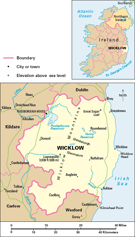
Wicklow, County, lies in the province of Leinster, on the east coast of the Republic of Ireland. With extensive mountains and forests, it is noted for its beautiful scenery and is called the garden of Ireland. Lying south of the city of Dublin, Wicklow is popular with Dubliners for recreation. People who live in the northern part of the county commute to work in the city. Bray is the largest town, but the town of Wicklow is the administrative center. The county covers an area of 782 square miles (2,025 square kilometers).

A majority of the people of County Wicklow are Roman Catholics. Most of the rest belong to the Church of Ireland or claim no religious affiliation.
Economy.
Farming in the uplands is quite different from that in the lowlands. The amount of land suitable for farming is limited. Sheep, which graze on the mountains, are very important, and include many of the Wicklow breed. Farmers also raise young cattle.
The lowlands are fertile and have more mixed farming. Barley, wheat, and potatoes are the main crops, with some oats, sugar beets, and turnips. Beef cattle production is of major importance. Dairy farmers supply milk to Dublin and to County Wicklow’s creameries. Some farmers raise sheep, hogs, and poultry.
Manufacturing takes place mainly in the towns of Arklow, Bray, and Wicklow. Engineering and the production of metal products and pharmaceuticals are the leading manufacturing industries. Factories in the county also make fertilizers, processed foods, plastic goods, pottery, printed materials, sawmilling and timber products, and textiles.
Tourism and recreation are of major importance in County Wicklow. Popular seaside destinations include Bray, Greystones, Brittas Bay, and Arklow. The mountains are the other great attraction, for sightseeing, driving, bicycling, and hiking.
Forestry is of great importance for commercial timber production and for recreation. County Wicklow is the most forested county in Ireland. Many forest sites are open to the public for recreation. A forest park near Rathdrum at Avondale was once the home of the Irish political leader Charles Stewart Parnell. Arklow is the only fishing port. In the northern part of the county, stone, sand, and gravel are quarried for building materials.
Land.
The Irish Sea forms County Wicklow’s eastern boundary. County Dublin lies to the north, County Kildare to the west, County Carlow to the southwest, and County Wexford to the south.
The Wicklow Mountains occupy the center of County Wicklow from north to south and dominate its landscape. They form the major part of the Leinster Chain, the most extensive area of upland in Ireland. Much of the mountain core consists of granite, which forms smoothly rounded summits. Lugnaquilla, which rises 3,039 feet (926 meters), is Leinster’s highest mountain. The sharp peak of Great Sugar Loaf mountain is a prominent feature in the northeast.
A series of deep glens and valleys extends along the eastern side of the mountains. The most famous is Glendalough, with its two lakes, and the longest is Glenmalure. The eastern slopes of the mountains drain mainly to the River Avoca. The west of the county drains to the rivers Liffey and Slaney.
Most of the lowland forms a wide strip in the eastern part of the county. The coast is low-lying except for some rocky cliffs. The coastline is mostly straight and fringed by stony or sandy beaches.
History.
The most important historical site in County Wicklow is Glendalough. Founded by Saint Kevin in the 500’s, Glendalough was one of the great Celtic monasteries of Ireland. Remains include a round tower, a gateway, and ancient churches.
The Vikings had coastal settlements at the towns of Arklow and Wicklow. Most of the county, however, remained under the control of the MacMurroughs, kings of Leinster. When these towns and the lowlands came under the Anglo-Normans, the uplands remained in the hands of the O’Byrne and O’Toole clans. From their mountain retreat, the Irish carried out periodic raids on the Anglo-Normans of what is now County Wicklow, and on Dublin and the Pale (the area ruled by the English) to the north.
County Wicklow came under English control in the 1600’s. But the Irish still used the mountains as a refuge, notably during the 1798 Rebellion. The government opened the mountain region by building a military road, which runs from north to south through the high uplands. Russborough House, near Blessington, is one of Ireland’s finest country houses dating from the 1700’s. County Wicklow suffered less than most counties during the Great Irish Famine of the 1840’s, although it lost one-fifth of its population through death and emigration.
