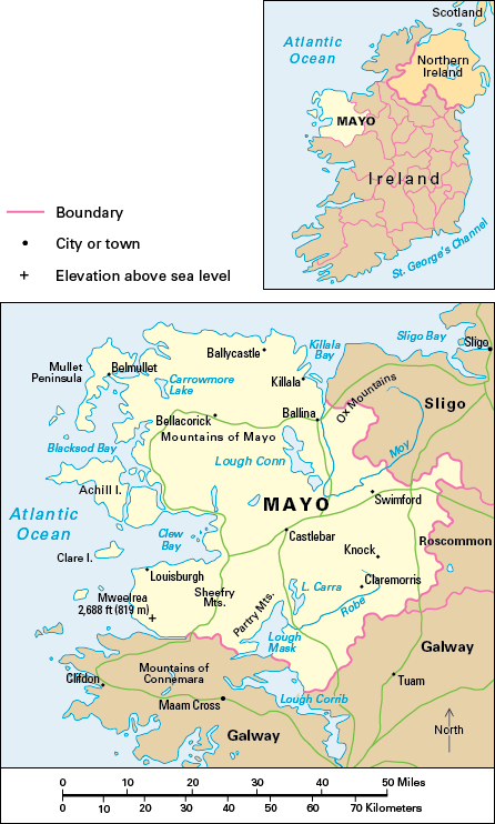
Mayo, County, is the third largest county in area in the Republic of Ireland. It covers 2,084 square miles (5,398 square kilometers) on the west coast and in the province of Connacht. County Mayo attracts many tourists and pilgrims. Ballina is the largest town, but Castlebar is the center of county administration.

Most of the people of County Mayo are Roman Catholics. The Church of Ireland is the largest of the other denominations.
Knock, in the eastern part of County Mayo, is one of the major pilgrimage sites of Europe. Children claimed to have seen the Virgin Mary appear before them at the church there in 1879. Many Irish people visit County Mayo on the last Sunday in July for a pilgrimage up a mountain called Croagh Patrick.
Most people in County Mayo use English as their everyday language. But in the west there are three Gaeltacht, areas where Irish is the everyday language. See Gaeltacht; Irish language.
Economy.
Farming is difficult in County Mayo because of poor land, unfavorable climate, and small farm size. Conditions are not suitable for growing crops, and most of the land is covered with grass. The raising of beef cattle is the principal type of farming, but dairy cattle and sheep are also important.
The main manufacturing centers are Ballina and Castlebar. Light engineering, clothing, and textiles are the most important sectors. A large synthetic-textile factory operates in Killala.
Retail and wholesale distribution rank among the county’s main service industries. Other service industries include catering, education, health care, and transportation. Tourism is important in the mountainous and coastal western part of the county.
For many years, the people of County Mayo used peat from the county’s bogs as a cooking and heating fuel. Later, they burned it to produce electric power. The mechanized cutting of peat bogs supplied an electric-power station at Bellacorick in the northwest. Peat bogs support many animal and plant species. They also play an important role in storing carbon that can contribute to climate change if released into the atmosphere. Growing recognition of the bogs’ value led to the closure of the county’s peat-fired plants and peat extraction facilities in the early 2000’s. Many peat bogs and other wetland sites in County Mayo have been restored.
Land.
The Atlantic Ocean forms County Mayo’s boundary on the north and west. County Galway lies to the south, and Counties Roscommon and Sligo to the east.
The eastern part of County Mayo is mainly limestone lowland. Between east and west are Loughs Conn and Mask. The Robe River flows into Lough Mask, and the River Moy, which has good salmon fishing, drains the northeast.
The western part of County Mayo is largely upland and peat bog with scattered tracts of farmland. The area has few people. Forests cover large areas of the uplands. In the south are the Mweelreo, Sheeffry, and Partry mountains. Mweelrea, which rises 2,688 feet (819 meters), is the highest peak in Connacht.
History.
Field walls dating from about 3000 B.C. near Ballycastle on the northern coast of County Mayo are among the largest Stone Age remains in the world. Later remains include those of monasteries from Celtic times and from the Middle Ages.
What is now County Mayo was once ruled by the O’Connors. But after the Anglo-Norman invasion in the 1100’s, lands were granted to the de Burghs, an Anglo-Norman family. County Mayo did not come under firm British control until the 1600’s. It was one of the counties most severely affected by the Great Famine in the 1840’s, when nearly a third of the population died or emigrated (see Great Irish Famine).
