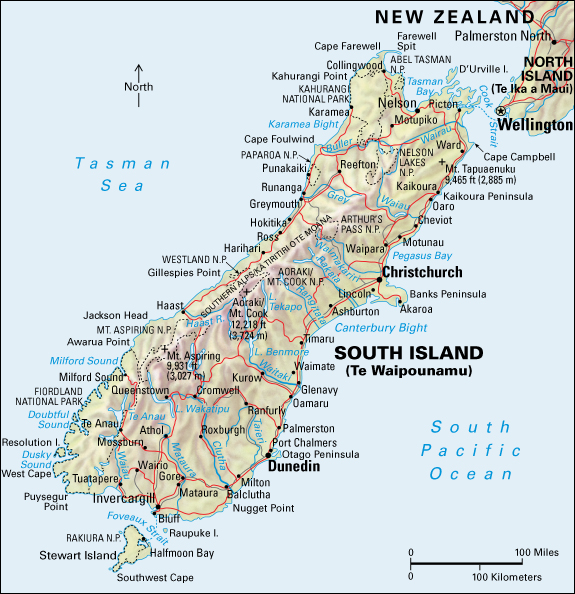
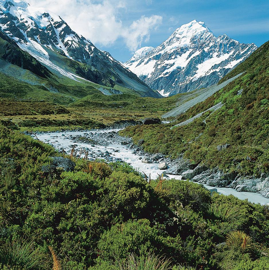
Canterbury is a statistical area in the east central part of the South Island of New Zealand. Although provinces no longer have any legal identity or political reality, New Zealanders still refer loosely to Canterbury as a province. Canterbury was the third largest of the old provinces. Today, it is one of New Zealand’s largest statistical areas. In the western part of the region, the mountains of the Southern Alps/Kā Tiritiri o te Moana tower above the foothills and downlands. In the east, the Canterbury Plains reach to the coast and form the largest area of flat land in New Zealand. Extensive sandy beaches are located north of Christchurch.

Land.
Canterbury is roughly rectangular in shape. It is about 180 miles (290 kilometers) long at its longest point and about 70 miles (113 kilometers) wide. The historic province of Canterbury was bounded on the north by the Hurunui River, on the east by the Pacific Ocean, on the south by the Waitaki River, and on the west by the Alps/Kā Tiritiri o te Moana. The statistical area extends slightly further northward.
Aoraki/Mount Cook National Park, an area of 270 square miles (700 square kilometers) in the central section of the Southern Alps/Kā Tiritiri o te Moana, is Canterbury’s chief tourist area and one of New Zealand’s greatest tourist attractions. This park includes Aoraki/Mount Cook, New Zealand’s highest mountain, and the Tasman Glacier, which is 18 miles (29 kilometers) long. Mount Hutt, near Ashburton, has popular ski areas.

The Canterbury Plains, comprising the central eastern coastal region, extend about 130 miles (210 kilometers) from Amberley in the north to Timaru in the south. Downlands (rolling, grassy areas) bound the plains to the north and south. In the central part of Canterbury’s eastern coast is the volcanic mass of Banks Peninsula, once thickly wooded and now agricultural land. The peninsula’s sheltered harbors, such as Lyttleton, the port of Christchurch, and Akaroa, are craters that were flooded by the sea. Lake Ellesmere is a shallow, brackish lake trapped by a barrier of shingle (loose stones or pebbles).
From Canterbury’s eastern coast, the plains slope gently inland for about 30 to 40 miles (48 to 64 kilometers) to foothills that rise abruptly toward the Southern Alps/Kā Tiritiri o te Moana. Chief peaks in the Canterbury section of the Southern Alps/Kā Tiritiri o te Moana include Aoraki/Mount Cook, which rises to a height of 12,218 feet (3,724 meters), and Mount Tasman, which is 11,473 feet (3,497 meters) high.
Melted snow and rains from the mountains feed Canterbury’s three largest inland lakes: Tekapo, Pukaki, and Ohau. From the lakes flow major rivers that originally formed the plains and now provide their main system of irrigation. Canterbury has nine rivers more than 50 miles (80 kilometers) long. They include the Waimakariri, the Rakaia, and the Rangitata.
On the Canterbury Plains, the annual rainfall averages 25 to 30 inches (64 to 76 centimeters). Frosts are frequent in winter, but snowfalls are infrequent and light. The mean temperature in January is 61 °F (16 °C) and in July 41 °F (5 °C). A distinctive feature is the hot, turbulent northwest winds of autumn and spring.
People.
Christchurch is Canterbury’s largest city. The port of Lyttleton, which is about 7 miles (11 kilometers) from Christchurch, serves the city. The second largest population area is Selwyn, a district in central Canterbury. The third most populous area is Waimakariri. Timaru, in the southern part of the region, is Canterbury’s second major port and fourth largest population center.
Economy.
Manufacturing employs more people than any other industry in Canterbury. The area has meatworks, textile mills, electrical engineering plants, and clothing, footwear, and tire factories.
Much of the land in Canterbury is used for farming or for forestry. Farms in the region produce barley, oats, peas, and wheat. The main fruit-growing areas are Loburn, Belfast, and Heathcote Valley. The region also raises livestock, including beef and dairy cattle, deer, hogs, and sheep.
Canterbury has extensive plantation forests. These forests consist chiefly of pine trees, larches, and firs, but there are also some hardwoods, such as poplars and eucalypts.
Canterbury takes much shingle from its rivers, particularly the Waimakariri, where some of New Zealand’s biggest stone-crushing plants operate. This crushed rock, used in concrete, is popular as a building material and is also used as the surface for Canterbury’s country roads.
Canterbury has a fishing industry. Fishing ports include Kaikoura, Akaroa, Lyttleton, Timaru, and Ellesmere.
Transportation and communication.
Main roads link Christchurch with Blenheim in the north; Lyttleton and Akaroa in the east; Dunedin in the south; Queenstown, Haast, and the southern lakes in the far southwest; The Hermitage, at Aoraki/Mount Cook, in the southwest; and Greymouth in the west. In 1965, engineers completed the main road linking Christchurch with Haast by way of Wanaka and the Haast Pass, on Canterbury’s border with Westland. A mountain road through Arthur’s Pass links Canterbury with Westland. But traffic to Westland centers, such as Greymouth, also travels by way of the better but longer road over the Lewis Pass, in Nelson.
Railroads link Christchurch with Blenheim and Picton in the north, Lyttleton in the east, Dunedin in the south, and Greymouth and Hokitika in the west. The western route passes through the 5-mile (8-kilometer) Otira tunnel.
Education.
Canterbury has government-run elementary schools and independent elementary schools, most of which are run by the Roman Catholic Church. There are government-run high schools and independent high schools. Higher-level institutions include a teacher’s college and technical institute. The University of Canterbury was founded in 1873.
History.
Whalers and sealers from Australia and elsewhere were the first Europeans in Canterbury. Historical records indicate that George Hempleman, a German-born whaling captain from Sydney, was one of the first European settlers.
In August 1840, the Nanto-Bordelaise Company, an association of French colonists, landed 57 French settlers at Akaroa. Although British sovereignty over the South Island had been proclaimed the previous June, the French settlers were allowed to remain in Akaroa.
In 1847, a group of British landowners, politicians, and churchmen, including the archbishop of Canterbury, formed the Canterbury Association. This group held its first meeting the following year to establish a Church of England settlement in the South Island. They called their settlement Canterbury, and the original province took this name. The English colonial statesman Edward Gibbon Wakefield led the move to form the association, and John Robert Godley became the association’s chief executive officer (see Wakefield, Edward Gibbon). In 1850 and early 1851, eight ships chartered by the association landed 1,500 British settlers at Port Cooper (now Lyttleton). Their first settlement was at Christchurch. About 500 Indigenous (native) Māori lived in Canterbury at the time.
In 1852, the British government granted the colony of New Zealand a constitution. The constitution created provincial governments, and Canterbury became a province. It developed quickly. In 1863, engineers built New Zealand’s first railroad, to link Christchurch with Ferrymead (now Heathcote). Four years later, this railroad was extended through a tunnel to Lyttleton. The provincial governments were abolished in 1876. They were replaced with smaller local governments.
