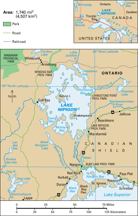
Lake Nipigon is a lake in the province of Ontario, Canada. The largest lake entirely within Ontario, it sometimes is called the sixth Great Lake (see Great Lakes ). Lake Nipigon is about 75 miles (120 kilometers) northeast of the city of Thunder Bay. It drains into the Nipigon River, which flows into Lake Superior at Nipigon Bay. The name Nipigon comes from the Chippewa (Ojibwa) word anemebegong, meaning continuous water. Lake Nipigon is famous for its impressive cliffs and its greenish-black sand beaches that are made of the mineral pyroxene.

Lake Nipigon has an area of more than 1,740 square miles (4,507 square kilometers). Its average depth is 180 feet (55 meters). The lake is in an ecological zone called the Central Canadian Shield forests. The Canadian Shield is a huge rocky region that covers about half of Canada.
One of the first Europeans to see Lake Nipigon might have been the French Jesuit missionary Claude Jean Allouez. Allouez led a Roman Catholic Mass near the Nipigon River in May 1667. Lake Nipigon had a variety of names on maps from the 1700’s and 1800’s. The names included Lago Nepigon, Lake St. Ann, Lake Winnimpig, and Red Lake. By the 1880’s, it was identified regularly as Lake Nipigon.
After the Seven Years’ War (1756-1763), Britain (now the United Kingdom) gained control of much North American territory, including the area around Lake Nipigon. Following the war, most of the area around the lake was within the trading territory of the Hudson’s Bay Company. By the Robinson Superior Treaty of 1850, the Chippewa Indians ceded to the Province of Canada the area that drained into Lake Superior, including Lake Nipigon. The Province of Canada was a British colony covering much of modern-day Canada. In 1871, Lake Nipigon became part of the Thunder Bay District of Ontario.
The Township of Nipigon, incorporated in 1908, is about 25 miles (40 kilometers) south of Lake Nipigon. Lake Nipigon Provincial Park is on the southeast coast of the lake.
