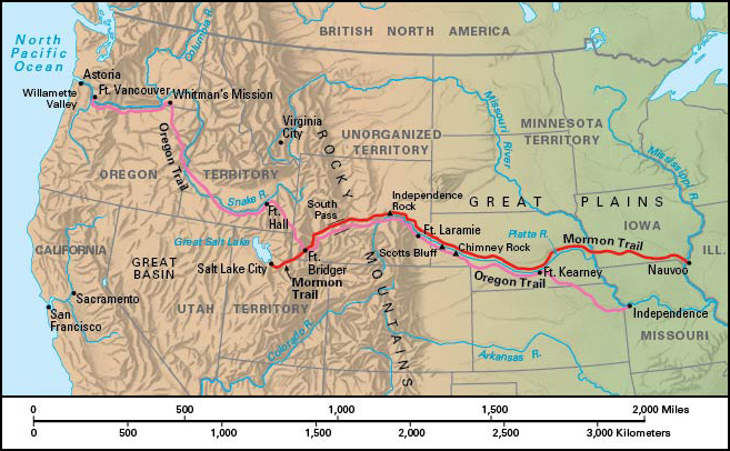
Mormon Trail was an important migration route for settlers traveling through the American West in the mid-1800’s. The 1,300-mile (2,090-kilometer) route began at the Mormon community of Nauvoo , in west-central Illinois. It crossed Iowa and followed the Oregon Trail westward before turning south into Utah . The route gained the name Mormon Trail for the thousands of members of the Church of Jesus Christ of Latter-Day Saints—sometimes also known as Mormons—who took the trail while fleeing religious persecution in the Midwest. The Mormons were among the first Americans of European descent to settle Utah.

Background.
In the late 1820’s, New York resident Joseph Smith claimed to receive a series of divine revelations. He published a holy book called the Book of Mormon and founded the Church of Jesus Christ of Latter-day Saints. The church’s followers became known as Mormons, though Church members are more correctly called Latter-day Saints. Smith and his followers converted thousands of people to the new religion during the 1830’s and 1840’s.
Non-Mormons came to object to the expansion of Mormon religious communities, and disagreements occasionally led to armed conflicts. Opposition to the church, some of it violent, led Smith and his followers to establish, and later flee, communities in Ohio and Missouri. Smith and his brother Hyrum were murdered by a mob in the Mormon community of Nauvoo, in western Illinois, in 1844. Missionary Brigham Young became the new leader of the church. Young was convinced that there could be no lasting peace for his people until they were completely separated from peoples of other faiths.
Westward bound.
Young prepared to relocate the Nauvoo settlers, who numbered about 15,000, to a planned refuge in what was then northern Mexico. In 1846, Young led about 3,000 followers on a journey across the Mississippi River and through Iowa. They established a temporary base straddling the Missouri River in the area of present-day Council Bluffs, Iowa, and Omaha, Nebraska. In April 1847, Young organized 148 settlers into a military-style advance party. The party headed west toward a previously planned site in the Great Basin. In late July, the group arrived in the Great Salt Lake valley, in what was then a part of northern Mexico. They soon established Salt Lake City . The following year, the Utah Territory became part of the United States as part of a treaty negotiated to end the Mexican War (1846-1848). Young would later assist in the migration of tens of thousands of other Mormons to the valley.
From Nauvoo, the Mormon Trail took settlers westward across southern Iowa to central Nebraska. The emigrants traveled by horseback, via covered wagon, or by pushing hand carts over the trail themselves. The settlers traveled along the north banks of the Platte and North Platte rivers to a trading post that later became Fort Laramie , Wyoming. They crossed the North Platte and followed the established route of the Oregon Trail through the South Pass in Wyoming’s Rocky Mountains. Young’s followers then traveled to Fort Bridger, in southwestern Wyoming. There they branched off from the Oregon Trail and continued westward to Great Salt Lake.
Along the way, the emigrants established several small settlements and river ferries to aid or resupply subsequent travelers. Many travelers’ journals noted such natural landmarks as Chimney Rock and Scotts Bluff in Nebraska and Independence Rock in Wyoming. Between 1847 and the late 1860’s, about 70,000 Latter-day Saints followed the Mormon Trail to Utah. Most groups managed the journey with little hardship, but hundreds of travelers died of disease or exposure.
Today,
the Mormon Pioneer National Historic Trail, a unit of the National Park Service , preserves important sections of the trail. Related sites are found in Illinois, Iowa, Nebraska, Utah, and Wyoming.
